

HYDROLOGY.
i. Iranian plateau. See ĀB.
i. IRANIAN PLATEAU. See ĀB.
From a hydrological perspective, southwestern Persia must be considered as part of the Persian Gulf drainage region (see DRAINAGE). Extending over an area of more than 350,000 km², its main drainage area covers the central and southwestern Zagros mountain areas with their extremely complex geomorphology as well as the western and southern Zagros forelands. Of special importance for southwestern Persia is the hydrological system of great river catchments areas (e.g., those of the Karḵa, Dez, Kārun, Mārun, and Rud-e Zohra among others) funneling their runoff from more than 45,000 square miles of the high Zagros into the 15,000 square-mile plain of Ḵuze-stān with all the consequences and problems of a typical highland-lowland interaction characteristic of many hydrological systems in high mountain environments, especially flooding.
In accordance with the above definition, the general components of the hydrological cycle may be described as follows: water evaporation from the ocean surfaces, condensation, precipitation, runoff, and groundwater flows. While the term “cycle” implies that there is neither a beginning nor an end to this perpetual water circulation process, it seems for our purpose appropriate to concentrate on the components “precipitation,” “runoff,” and “groundwater flows.” Before these it must be mentioned, however, that southwestern Persia has significant ecological advantages compared to many other parts of the country (see ECOLOGY). Due to the pronounced topography of western Persia, with the Zagros mountains rising to more than 4,000 meters in height, and due to their northwest-southeast configuration in relation to the moist, winterly, and predominantly westerly air masses of Mediterranean origin, southwestern Persia receives above-average precipitation in the form of both rain and snow. Geology and climate have therefore resulted in an almost unique drainage pattern, which, from a geomorphological perspective, has been thoroughly investigated (Oberlander, 1965).
Precipitation. Mediterranean cyclones provide precipitation which falls mainly in late autumn and in the winter months. The average annual amount of rainfall over southwestern Persia can be estimated at approximately 500 to 600 mm/year. This average is, however, extremely variable due to topography and exposition. In general, one may say that the higher reaches of the Zagros mountains receive much more precipitation (reaching in excess of 1,000 mm) than their basins and forelands. The same holds true for the western ranges of the Zagros compared to their eastern counterparts, located in the rain shadow of the central Zagros; for instance, while Kermānšāh received an average of 470.6 mm/year in a given period, Isfahan received only 98.6 mm/year in the same period (Ehlers, 1980, table 6). The winter snowfall in wide parts of the high Zagros ranges has a significant effect. While detailed statistics are lacking due to the absence of meteorological stations, C. Preu (1984, pp. 44-55) argues that the high regions of the Zagros are characterized by 8 months of precipitation with more than 100 mm of precipitation per month. Only the summer months (June-September) are without rain or snowfall (see GLACIERS). Altogether, southwestern Persia can be considered a relatively favorable region hydrologically in Persia, providing corresponding benefits to its overall environmental performance (see ECOLOGY).
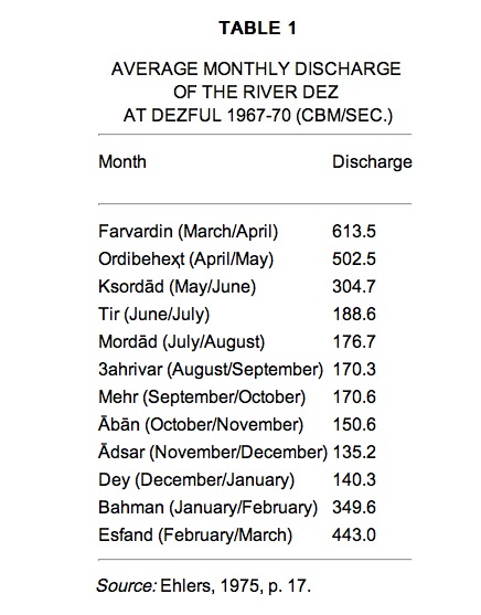
TABLE 1. Average monthly discharge of the river Dez at Dezful 1967-70 (cbm/sec.).
Runoff. As is to be expected, river runoff is remarkable in southwestern Persia, where the Kārun, Iran’s longest river, flows in a southwesterly direction out of the central Zagros ranges. However, it should be noted that the dividing line between interior and oceanic drainage does not coincide with the snowy ridgepole of the Zagros. Instead, it is shifted towards the interior south of Hamadān and follows a series of dry ranges of inferior elevation to the east of the line of great peaks. Thus streams running down to the Persian Gulf must first breach the very ranges upon which they are born—an initial manifestation of perplexing drainage anomalies which make the Zagros streams some of the world’s most interesting from a geomorphological perspective (Oberlander, 1968, p. 269). It is a “transverse drainage system in an orogenic zone” (Oberlander, 1965), contributing to the difficult accessibility of this region and to the function of the Zagros as not only a natural, but also a historical and cultural, divide between Mesopotamia and the Iranian plateau. Runoff patterns of rivers in southwestern Persia are determined by the precipitation cycle, which is nowadays affected by dam constructions and other forms of human interference. Before these human impacts, the Kārun, for instance, had a maximum discharge of 60,000 to 75,000 cu. ft./sec. and a minimum discharge of approximately 7,000 cu. ft./sec. in October (Oberlander, 1968, p. 269). Other river systems follow similar discharge patterns: “The westward flowing streams of the central Zagros mountains, having relatively large catchments and being nourished by springs and snowmelt from extensive areas lying between 12,000 and 15,000 ft., maintain significant flows during the dry months. Measured at the mountain front, the minimum flows of the Karkheh, Diz, and Karun rivers have averaged 880, 1,765 and 3,000 cu. ft. per second respectively” (Oberlander, 1968, p. 271).
An example of the seasonality of river discharges in southwestern Persia is the river Dez at the gorge of Dezful. Based on an observation period between September-October 1967 and August-September 1970, the monthly average runoff (in cbm/sec.) of the river ranges between 613.5 cbm/sec. in early spring and 135.2 in the fall. The river Dez and its tributaries are also characterized by distinctly low discharges during the summer and autumn months, while the period between March and May represents the peak season (Ehlers, 1975, p. 17). It should be noted that, under conditions of heavy rainfall, especially when it coincides with snowmelt, the fluvial runoff and discharge of Zagros streams can lead to disastrous floods in the lower reaches of the drainage system, especially in the province of Ḵuzestān. Such extreme floods can cause loss of human life, destruction of fields and harvests, and physical damage to settlements, highways, and railway tracks.
Groundwater flows. Unlike other parts of Persia, southwestern Persia is characterized by the “presence of a several thousands meters thick sequence of calcareous aquiferous rocks of Oligo-Miocene, Eocene, Cretaceous and even Jurassic age” (Issar, 1969, p. 95), as well as by “two other aquifers of local importance namely the Baḵ-tiāri conglomerates of the Mio-Pliocene age and the Pleistocene alluvial fill of the synclines” (Issar, 1969, p. 97). The strata are important, not only for the formation of groundwater, but also for the permanent discharge in the form of springs, as well as for their replenishment by precipitation. From a hydrological perspective, it seems very probable that most of the Zagros anticlines form a kind of local “subsurface watershed as can be seen from the numerous springs emerging along the flanks of the anticlines,” and “it seems thus probable that the big springs emerging from the limestone and feeding from the Kārun and Dez rivers are the outlet of the interregional aquifer of the Zagros extending to the north as well as to the south of the rivers” (Issar, 1969, p. 97).
Equally important as groundwater-fed springs are those subsurface water resources that circulate in the mountain forelands close to the ground surface. While, in an overall perspective, groundwater flows may be small (extraction/recharge: 20 billion m3/year) compared to the national surface runoff (110 billion m3/year; cf. Beaumont, 1974, p. 420), groundwater flows are of great economic importance for irrigation purposes by means of qanāts (tunnels which lead water from below the water table to the ground surface by gravity flow; see ĀB iii.) or, at present, mainly by wells. However, their use, or rather over-use, has led to a dramatic lowering of the groundwater table.
Economic considerations. Southwestern Persia may be characterized as one of Persia’s hydrologically favored areas, in spite of the fact that large tracts of the province of Ḵuzestān are desert or semi-desert. On the other hand it must be noted that, while surface runoff, springs, and groundwater extraction are major sources of irrigation developments in the mountain regions themselves, these factors are even more critical in the southwestern forelands of the Zagros ranges. Efficient management of water enabled the prosperity of the earliest Persian civilizations (Adams, 1962; Hole, Flannery, and Neely, 1969) and in Sasanian-Roman antiquity (Adams and Hansen, 1968), but this phase was followed by a decline in the irrigation systems, waterlogging, and desertification in medieval and modern times. Only after World War II would a renaissance of irrigated agriculture be witnessed. Large dam projects and canal systems (Beaumont, 1974; Ehlers, 1975) have contributed to extensive irrigation schemes between Andimešk and Šuštar, and in other parts of the province of Ḵuzestān; they have had a major impact on the traditional hydrology of southwestern Persia.
Bibliography:
R. McC. Adams, “Agriculture and Urban Life in Early Southwestern Iran,” Science 136, 1962, pp. 109-22.
Idem and D. P. Hansen, “Archeological Reconnaissance and Sounding in Jondi Shahpur,” Ars Orientalis 7, 1968, pp. 53-73.
P. Beaumont, River Regimes in Iran, University of Durham, Department of Geography, Occasional Publications N.S. 1, Durham, 1973.
Idem, “Water Resource Development in Iran,” The Geographical Journal 140, 1974, pp. 418-31.
Eckart Ehlers, Traditionelle und moderne Formen der Landwirtschaft in Iran, Marburger Geographische Schriften 64, Marburg, 1975.
Idem, Iran. Grundzüge einer geographischen Landeskunde,Wissenschafliche Länderkunden 18, Darmstadt, 1980.
A. Issar, “The Groundwater Provinces of Iran,” Bulletin of the International Association of Scientific Hydrology 14/1, 1969, pp. 87-99.
T. Oberlander, The Zagros Streams: A New Interpretation and Transverse Drainage in an Orogenic Zone, Syracuse Geographical Series 1, Syracuse, 1965.
T. M. Oberlander, “Hydrography,” in W. B. Fisher, ed., Camb. Hist. Iran I, pp. 264-79.
C. Preu, Die quartäre Vergletscherung der inneren Zardeh-Kuh-Gruppe (Zardeh-Kuh-Massiv), Augsburger Geographische Hefte 4, Zagros, 1984.
(ECKART EHLERS)
Scientific knowledge of the hydrology of Afghanistan is as yet very inadequate. Johannes Humlum’s account (pp. 38-51), was based on a very incomplete set of data. In the course of three decades (1950-80), a network of measuring stations was set up in Afghanistan, already amounting to 167 stations by 1977. However, the results, which were published in regional hydrological annuals (15 vols. altogether) in Kabul between 1977 and 1982, were recorded only roughly and have not been systematically calculated yet. Valuable early attempts at a synthesis (Grötzbach, pp. 36-45; Balland, 1992, pp. 112-15) have, nonetheless, enabled a preliminary outline of a typology of the waterways. At the same time, a large number of inventories of subterranean hydrological resources, both regional (Sammel; MacClymonds; Wagner; Radojicic, 1978a, 1978b) and global (UNDP, 1972), have provided the basis for an initial overall impression of these (Malyanov).
The waterways of Afghanistan are essentially divided into three main catchment areas. (1) To the southeast and east of the country, the network of the Kabul river, with its tributaries, the Lōḡar, the ʿAlinegār, the Panjšēr, and especially the Konar (average discharge of 373 cbm/sec. at Asmar), drains Nurestān and the southern slopes of the highest chains of the Hindu Kush and thus represents 43.5 percent of the total discharge in the country. These waters reach the sea by way of the Indus. (2) On the southern and southwestern slopes of the central mountains, a series of waterways—Aḏraskand, Farāhrōd, Kāšrōd, Helmand (186 cbm/sec.) with its tributary, the Arḡandāb (45 cbm/sec.)—head southwest and end up in the Sistān basins on the border with Persia. They account for about 24 percent of the total discharge. (3) To the north and west of the country, the rivers run towards the closed basins of Central Asia (32.5 percent of the total flow of the country). They consist of the important tributaries (Kōkča and the river of Kondoz) to the west of the Āmu Daryā, the gigantic river which in its upper course forms the border between Afghanistan and the former Soviet Central Asian states. Their average discharge has been recorded as 2,050 cbm/sec. at Karki a short distance beyond the Afghan border. These waters end up in the Aral Sea. Further west, the small waterways running down the northern slope of the central mountains (the river of Ḵolm, Balḵāb, the river of Anḏkoy, etc.) no longer reach the Āmu Daryā; spent mainly by their use for irrigation, they come to an end in the oasis of Bactria. Even further west, on the northwestern and western slopes of the mountains, there are rivers that extend outside of Afghanistan: the Morḡāb in the northwest stretches as far as the oasis at Marv; the Herirōd, having fed the large oasis of Herat, suddenly veers northwards; it forms part of the border between Persia and Afghanistan and then that between Persia and Turkmenistan under the name of Tajen/Tedzhen, finally terminating at the oasis of Tajen.
As knowledge about these different catchment areas has increased, initial assumptions that the opposite slopes of the mountains must be very contrasting have had to be revised. Excluding the rivers to the east and southeast (belonging to the network of the Kābolrōd), which receive the waters of the highest and most irrigated sectors of the Hindu Kush and thus acquire exceptional discharge coefficients, the total amount of discharge of the rivers is more or less the same north and south of the mountains. Calculations for five main waterways at their outlets on the foothills to the north—Farkār, Sorḵāb (i.e., the upper course of the Kondoz river), Ḵolmāb, Balḵāb, and Širin Tagāw/Tagāb—have recorded a rate of 3.3 lit/sec/km2; to the south, Ḡaznirōd, Arḡandāb, Helmand, Ḵāšrōd, and Farāhrōd achieve a rate of 3.4 lit/sec/km2. The peculiarities of the systems differentiate the opposite slopes far more than the specific rates of discharge. For the same above-mentioned rivers, the discrepancy between the highest and lowest average monthly rates of discharge does not exceed 12 in the north (11.2 for the Farḵār at Ṭā-laqān) and usually amounts to between 3 and 5. In the south, however, it almost always exceeds the latter figures (4.5 for the Helmand at Kajakay, 7.4 for the Ḡaznirōd at Band-e Solṭān, 8.8 for the Arḡandāb at Dahla) and reaches breathtaking rates for the Farāhrōd (46.4 at Pēč Tangi) and for the Ḵāšrōd (382.8 at Delārām). While the waterways from the southern slope practically dry up for part of the year, in the north the yearly margin of variability (ratio between the highest and lowest annual rates of discharge) is remarkably stable, almost always amounting to between 2 and 2.5. However, it is almost always above 4 in the south, reaching 8.5 for the Farāh-rōd, 8.9 for the Arḡandāb, and up to 63.4 for the Ḵāšrōd. On the whole, Bactria thus has a much more regular seasonal water supply than regions in the south, and an even more regular annual supply. Nonetheless, on the whole, the total volume is not any greater (Balland, p. 115).
The monthly rates of discharge divide the waterways of Afghanistan into two main groups. (1) The waterways running down the Hindu Kush and the high central mountains, which receive a large supply of snow and even ice, reach their maximum levels in late spring or early summer, from May to July (usually in June; e.g., Sorḵāb at Pol-e Ḵomri; see Figure 1, A), sometimes in May to June (e.g., Balḵāb at Rebāṭ-e Bālā), others in July (e.g., Konar). The low water season is from October to March, reaching a minimum level usually in February. (2) The waterways in western Afghanistan, where the mountains are lower and the snowfall less heavy, depend strictly on rainfall, and thus reach their maximum levels usually between March and April (for instance, March for the Ḵāšrōd and the Arḡandāb, April for the Helmand and the Farāhrōd). The lowest levels, due to evaporation during the summer, are reached in autumn (minimum in September for the Helmand, October for the Farāhrōd).
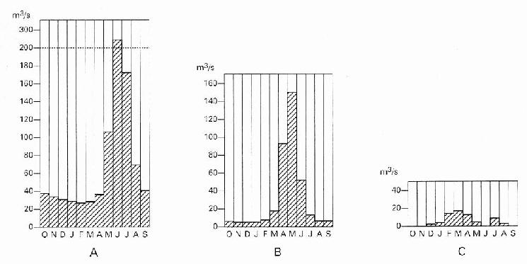
A transition group between the two above-mentioned types can be found on the western slopes of the central mountains. The Herirōd thus still has its monthly maximum in May at Čaḡčarān, but this spreads much more towards the beginning of spring than towards summer (it is much higher in April than in June; see Figure 1, B).
Secondary regional contrasts should be added to this basic scheme. The rivers from the northern slopes, which run towards Bactria, normally reach their maximum levels later (from April to June) than those of the southern slopes (March to May), thus improving the use of these waters for irrigation (Balland, p. 115). On the other hand, scattered on the southern slopes there are various abnormal systems which reach secondary peak levels that are produced by late storms (e.g., Arḡestān at Kandahar, secondary maximum of July; see Figure 1, C). The same can be observed in the southeastern slope of Paḵtiā as far as the Kabul region, on account of the arrival in Afghanistan of the last showers of the Indian summer monsoon. Thus, the small waterways at the border with Pakistan may reach their maximum levels in the period between July and September, followed by a second peak level in the period between January and April (Humlum, p. 43).
All these waterways, as well as the numerous large sources emerging from the central mountains, have long been used for irrigation, especially on the northern slopes of the mountains (Bactriana), where innumerable little diversion dams have been made. Moreover, major reservoir barrages (see band) have been built for irrigation in the Helmand basin, especially on the southern slopes, and for electricity in the Kabul area.
Underground waterways serve as the main water supply for all the arid sectors of the foothills, especially in the west and south, but also in Bactria. Here they are exploited essentially by wells reaching down as deep as 60 meters below ground. They are often salty due to the presence of gypsum and salt layers in the tertiary soils. However, there are excellent sweet water expanses to the northeast in the Qaṭaḡan plain, as well as to the west of Herat, where they are fed by infiltrations from the waters of the Herirōd. On the southern slope, these underground waters are exploited by wells 20 to 40 meters deep in the Jalālābād and Parwān basins, which obtain water of good quality due to the nearby mountains. The same is true of the plains of Ḡazni and Kaṭawāz, where there are many power-driven wells. However, the peculiarities of the southern slope make it necessary to exploit the water sheets through underwater drainage channels (kārēz/kāriz), which is the normal way of using the interfluves, for example in the major oasis of Kandahar. The kārēz are, however, rare in Bactria. This contrast can be considered a major cultural phenomenon. It shows how early the Bactrian foothills were being exploited by means of diversion channels, at a time when the kārēz technique, which only spread under the Achaemenids, had not yet been introduced to this area (Balland).
Afghanistan also has mineral and thermal springs in various locations, but they have been used very little so far, and the exploitation of these resources has hardly started. It is known that warm water sources with high mineral contents are located across a long tectonic fracture line which corresponds, especially to the west, with the course of the Herirōd, from Estālef, in the Kabul basin, westwards to the Ōbē thermae (water at 41°C). The latter, located 110 km east of Herat, have for a long time attracted the sick, as they pass through Bāmiān. Other sources of the kind exist in Bactria (e.g., Čašma Ṣafā in the Balḵāb basin).
Bibliography:
Daniel Balland, “La place des galeries drainantes souterraines dans la géographie de l’irrigation en Afghanistan,” in idem, ed., Les eaux cachées: Etudes géographiques sur les galeries drainantes souterraines, Paris, 1992, pp. 97-121.
L. Fischer and G. Hauser, “Untersuchungen über die Mineralquellen Afghanistans,” Archiv für physikalische Therapie 6, 1954, pp. 316-40.
Erwin Grötzbach, Afghanistan, eine geographische Landeskunde, Wissenschaftliche Land-erkunden 37, Darmstadt, 1990.
Johannes Humlum, La géographie de l’Afghanistan: Etude d’un pays aride, Copenhagen, 1959.
N. E. MacClymonds, “Shallow Groundwater in the Zamin Dawar Area, Helmand Province, Afghanistan I,” U.S. Geological Survey, Open File Report, 1972.
E. P. Malyarov, “Gidrologischeskie usloviya Afghanistan,” in Sh. Abdulla and V. M. Chmyriov, eds., Geologiya i poleznye iskopaezmye Afghanistana, Moscow, 1980, II, pp. 118-42.
S. Radojicic, A Note on Water Resources of Afghanistan, Prepared for Water Supply and Sanitations Sector Study, UNICEF/World Health Organization, Kabul, 1977.
Idem, Water Resources Development Prospects for the Water Supply of Rural Population in Ghazni Province, UNICEF/World Health Organization, Kabul, 1978a.
Idem, A Note on Hydrogeological Reconnaissance of Deh-Sabz BHC and Qala-i-Bakhtyar in the Kabul Vicinity, UNICEF/World Health Organization, Kabul, 1978b.
E. A. Sammel, Ground Water Reconnaissance in the Arghandab River Basin near Kandahar, U.S. Geological Survey, Open File Report, 1971.
United Nations Development Program, Groundwater Investigation: Afghanistan, unpubl. report, 2 vols., New York.
W. Wagner, Grundwasser (Grundwasser Potential), Hanover, 1972.
(XAVIER DE PLANHOL)