

ECOLOGY, the study of organisms, both flora and fauna, in relation to their environments. The biosphere generally encompasses the thin outer shell of the earth, which includes soil and surface rocks, bodies of water, the lower atmosphere, and the life forms that inhabit these zones. The biosphere of Persia is divided into several ecosystems, determined mainly by geographical (climatic differentiation, topography, soil type, etc.) and biological (vegetation, wild life, etc.) factors (see BĀRĀN; CLIMATE; DESERT). Five primary ecological regions may be distinguished in Persia, each with a characteristic combination of features: the Caspian lowlands, the Alborz system and mountain ranges in Khorasan, the Persian plateau, the Zagros system with the Makrān mountain ranges, and the lowlands along the Persian Gulf. Although most of these regions can be easily defined and characterized, the vast Persian plateau is host to considerable variation in vegetation cover. Four components are of decisive importance: climatic differentiation, phytogeographical diversity, the impact of topography, and the role of human intervention in nature.
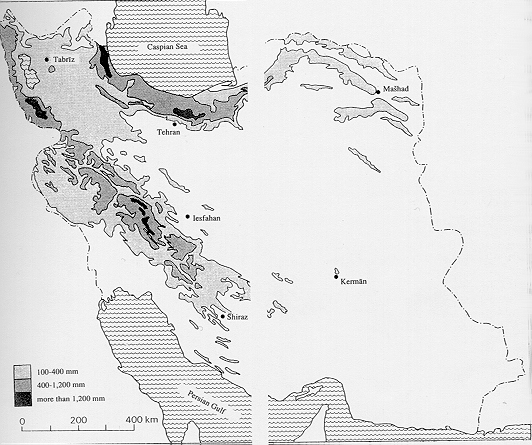
Climatic differentiation. Persia is located between the continental, anticyclonic air masses of Central Asia and Siberia in the north; the Mediterranean wind regime in the center, with westerly winds and wandering depressions bringing rain and snow, especially in winter; and tropical and subtropical, even monsoonal, influences in the southern and southeastern parts of the country. This position produces marked regional differences in climate and mean annual water surpluses and deficits. The climate ranges from humid subtropical lowlands along the southern coast of the Caspian Sea (annual precipitation almost 2,000 mm, recorded at the Anzalī/Rašt station) to hot, dry deserts (e.g., Dašt-e Kavīr and Dašt-e Lūt, averaging less than 100 mm of precipitation annually).
The Alborz and Khorasan ranges, the Zagros system, and northwestern Persia receive considerable surplus precipitation (Figure 1). They are thus humid for parts of the year or, in the Caspian lowlands, all year round. The vast majority of Persian territory, however, is characterized by extreme deficits. Lack of precipitation, strong or permanent winds or both, and high temperatures combine to create high potential evaporation and therefore extreme aridity in most parts of the country.
Climatic differentiation corresponds well with ecological differentiation. Henri Pabot considered that 90 percent of Persia belongs to the “Irano-Turanian” climatic zone, with the following characteristics: “extremely variable precipitation, but generally between 100 and 500 mm; maximum in winter or spring. At least three summer months of total drought extending up to nine months in the most arid regions. Relative humidity in winter between 80 percent and 55 percent (central desert), falling in summer to below 40 percent and even down to 20 percent. Very variable temperatures, depending on the region, but winters generally cold or very cold. Summers extremely hot in the Khuzestan plain (average July above 36° C), very hot in the central depression (more than 30° C), hot or quite hot (24 to 29° C) everywhere else, except above 2,000 to 2,500 meters altitude. The average annual range of temperatures (continentality) varies from 21° to 28° C, but is generally more than 24° C. The daily variations in temperature are also very large. There is a large variability in the precipitation and even the winter temperatures from one year to the next” (p. 17).
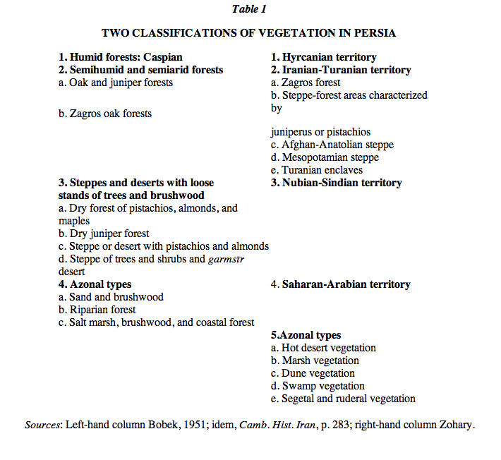
Phytogeographical diversity. The natural vegetation cover and its density, composition, and differentiation are direct functions of the Persian climate, in combination with soil and other topographical factors. Botanists and biogeographers have proposed four or five biogeographical regions, which are set forth in Table 1. The comparison of these classifications with climatic regions reveals close similarities in distribution patterns: vegetation as a reflection of and adaptation to climate. Both Harry Bobek and Michael Zohary stress the strong presence of forests; it should be noted, however, that vegetation other than forest actually predominates. From an ecological point of view, only parts of the Caspian/Hyrcanian regions may be considered genuine forests, whereas the Zagros and other mountain ranges are characterized by xerophilous forest flora. In an analogy to his Iranian-Turanian climatic zone, Pabot described an Iranian-Turanian flora, which covers more than 85 percent of the territory of Persia. Noting the great richness and variety of species in Persia, Pabot suggested an ecological subdivision into phytogeographical subtypes: subdesert flora, steppe flora, substeppe flora, xerophilous forest flora, and high mountain flora. Xerophilous forest flora will be dealt with in greater detail elsewhere (see FOREST), but the other subtypes may be characterized here, according to ecological adaptation.
Subdesert flora consists of scattered vegetation in the most arid regions, notably the deserts of endorheic central Persia, with high salt concentrations in the moist basins (kavīr), shifting sands, and the scars of human interference. Halophilous plants predominate, and perennial grasses are generally absent.
Steppe flora covers areas with mean annual precipitation of 100-250 mm and consists of varied vegetation, determined by winter temperatures. Grasses of different kinds were very common in the past but have been greatly reduced by human activity, particularly grazing of animals. Artemisia herba-alba is the predominant shrub and Aristida plumosa normally the predominant grass.
Substeppe flora, an originally very rich vegetation, has been greatly altered by dry farming and other forms of human intervention. According to Pabot (p. 29), “numerous species originating from the steppic zone have penetrated into this substeppic zone, frequently giving the impression that the rainfall is lower than it in fact is.” Herbaceous flora (including Compositae, Labiatae, Umbelliferae, Leguminosae, Graminaceae, Cruciferae, and other genuses) is much richer here than in the steppe zone. It may well be that pistachio forests of varying density are the “climax” vegetation of this zone, with perennial grasses equally common and widespread.
High mountain flora with limited growing seasons is restricted to the upper reaches of the mountain systems. It is characterized by the spiny, cushion-like tragacanth species (Astragalus spp. and others) and many other endemic plants.
Topography. Both climate and vegetation are strongly dependent upon topography, including relief. The Alborz and Zagros are probably the most striking examples of topographical influence on the natural habitats of flora and fauna. Owing to abundant rainfall on the northern slopes of the Alborz and the western slopes of the Zagros, those regions developed more or less dense forest cover. Bobek (1952) has thus suggested a vertical classification of vegetation, using Persian terms to characterize the thermal regime: sarḥadd, subtropical high regions with very cold winters and cool summers; sardsīr, subtropical moderately high regions with very cold winters and warm summers; subtropical highlands with three climatic subtypes (cold winters, hot summers, and strong frosts; mild winters, hot summers, and short frosts; mild winters, hot summers, and rare frosts); and garmsīr, subtropical lowlands with warm winters, hot summers, no frosts, and no snow.
Another decisive factor is soils, further proof of the ecological diversity of Persia. According to M. L. Dewan and J. Famouri, there are four physiographical regions in Persia, encompassing nineteen soil associations. The soils of the plains and valleys cover an area of approximately 300,000 km2. They include fine-textured alluvial soils, saline soils (solonchak and solonetz) typical of dašt areas and the many endorheic basins. Soils of the plateaus cover approximately 470,000 km2 and include gray and red desert soils, sierozems (extremely calcareous soils), and brown steppe soils, which are probably the most widespread types. Soils of the Caspian piedmont cover an area of approximately 35,000 km2 and are related to the special climatic and floral conditions in the Caspian region, known for brown forest soils; red-yellow podzolic soils prevail, characterized by high humus content and intense weathering. Because of the rugged topography of Persia and the distribution of mountains, combined with extremely dry climates and lack of vegetation, almost 50 percent of the land surface on dissected slopes and mountains is composed of soil types that are generally stony, shallow over bedrock, without a definite profile, and containing high proportions of unweathered rock fragments. The lack of profile may reflect recent exposure or, more likely, forces of natural erosion vigorous enough to remove fine-textured soil material as rapidly as it is formed. These soils may be called lithosols. They are found in all climates but are particularly associated with arid and semiarid areas (Dewan and Famouri, p. 258).
Topography is a major component of ecological differentiation in Persia, especially because of the impact of the Alborz and the Zagros on the distribution of precipitation and the corresponding vegetation cover.
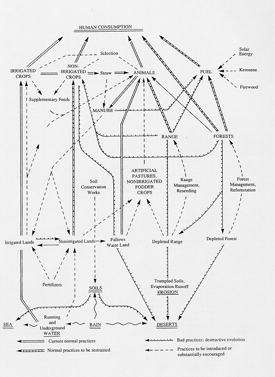
The human impact on nature. Persia has an ancient and more or less continuous settlement history in areas that favor human occupation. Human exploitation of the land must therefore be considered one of the most prominent ecological factors. The impact of this exploitation on the natural environment has been quite varied and sometimes even disastrous, owing to the fragility of most ecosystems. Major manifestations include destruction of forests for firewood and charcoal and agricultural colonization; expansion of agriculture into areas not ecologically viable (arid steppes, steep slopes), destroying the natural vegetation cover and greatly contributing to wind and water erosion of the soil; overgrazing of natural pastures by sheep and goats, with increasing negative selection of noxious plant species and of annual over perennial plants; and the trampling and compacting of soils and removal of bushy or slightly ligneous species for fuel, which have contributed to the impoverishment and destruction of natural vegetation. All these factors have greatly contributed to a strong degradation of the natural environment, with increasing desertification and destruction of formerly stable ecosystems (Figure 2).
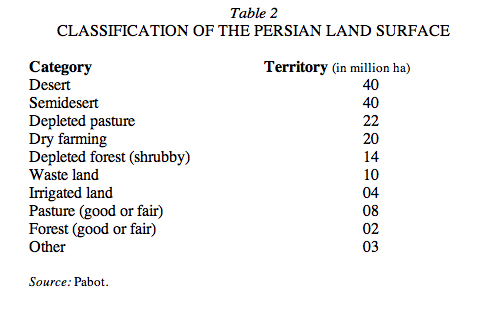
Almost all human activities have consequences for the natural environment. Population pressure; new agricultural techniques; increased use of water for agriculture, industry, and rapidly growing urban centers; industrial pollution; and problems of waste management have contributed to the country’s rapid and accelerating ecological degradation. According to Pabot, the total Persian land surface of ca. 163 million ha can be classified as in Table 2. It is clear that Persia needs a well-defined and sustainable ecological policy not only to prevent further damage to its extremely fragile natural environment but also to ensure a reversal of current trends and to restore damaged ecosystems.
Bibliography:
H. Bobek, Die natürlichen Wälder und Gehölzfluren Irans, Bonner Geographische Abh. 8, Bonn, 1951.
Idem, “Beiträge zur klima-ökologischen Gliederung Irans,” Erdkunde 6, 1952, pp. 65-84.
Idem, “Vegetationsverwüstung und Bodenerschöpfung in Persien und ihr Zusammenhang mit dem Niedergang älterer Zivilisationen,” International Union for Conservation of Nature and Natural Resources I, Brussels, 1959, pp. 72-80.
Idem, “Die Salzwüsten Irans als Klimazeugen,” Österreichischen Akademie der Wissenschaften, Phil.-histo, Kl., Anzeiger 3, 1961, pp. 7-19.
Idem, “Vegetation,” in Camb. Hist. Iran I, pp. 280-93.
D. B. Carter, C. W. Thornthwaite, and J. R. Mather, “Three Water Balance Maps of Southwest Asia,” in Publications in Climatology, Laboratory of Climatology 11/1, Centerton, N.J., 1958.
M. L. Dewan and J. Famouri, “Soils,” in Camb. Hist. Iran I, pp. 250-63.
J. Dresch, “Bassins arides iraniens,” Bulletin de l’Association des Géographes Français 430, 1975, pp. 337-51.
W. Frey and H. J. Mayer, “Botanische Literatur über den Iran,” Botanisches Jahrbuch 91, 1971, pp. 348-82.
M. H. Ganji, “Climates of Iran,” Bulletin de la Société de Géographie d’Egypte 28, Cairo, 1955, pp. 195-299.
Idem, Climatic Atlas of Iran, Tehran, 1965.
Idem, “Climate,” in Camb. Hist. Iran I, pp. 212-49.
J. V. Harrison, “Geology,” in Camb. Hist. Iran I, pp. 111-85.
A. Issar, “The Groundwater Provinces of Iran,” Bulletin of the International Association of Scientific Hydrology 14/1, 1969, pp. 87-99.
X. Misonne, “Mammals,” in Camb. Hist. Iran I, pp. 294-304.
T. M. Oberlander, “Hydrography,” in Camb. Hist. Iran I, pp. 264-79.
H. Pabot, Pasture Development and Range Improvement through Botanical and Ecological Studies, Food and Agricultural Organization (FAO) Report to the Government of Iran, 2311, Rome, 1967.
R. Rol, Les études écologiques et systématiques sur la flore ligneuse de la région Caspienne, FAO Report 520, Rome, 1956.
K. Scharlau, “Geomorphology,” Camb. Hist. Iran I, pp. 186-94.
J. Stöcklin, “Structural History and Tectonics of Iran. A Review,” American Association of Petroleum Geologists Bulletin 52, 1968, pp. 1229-58.
O. R. Weise, “Morphodynamics and Morphogenesis of Pediments in the Desert of Iran,” Geographic Journal 144, 1978, pp. 450-62.
M. Zohary, On the Geobotanical Structure of Iran, Jerusalem, 1963.
(Eckart Ehlers)
Originally Published: December 15, 1997
Last Updated: December 8, 2011
This article is available in print.
Vol. VIII, Fasc. 1, pp. 84-88