

DRAINAGE, the carrying away of excess surface water through runoff in permanent or intermittent streams. On Persian territory, because of seasonal variations in the climate, surface runoff also varies considerably at different times and in different places.
There are basically three sources of water for drainage: rainfall remaining after evapotranspiration and infiltration into the ground, water released from storage, and water held in aquifers. Persia is characterized by generally scanty but seasonal patterns of precipitation. Owing to the geomorphology of the country, precipitation is markedly higher on the periphery, especially in the northern and western regions, whereas the central, eastern, and southeastern areas are extremely arid (see DESERT), with extremely limited surface runoff through only a few stream systems. Permanent streams can be found especially along the northern slopes of the Alborz mountain range, which receive considerable rainfall during most of the year, though there is a distinct peak during the winter months; these mountains block the movement of moist air masses to the south. Farther to the west, in the Zagros mountain range, surplus water is collected in extended stream systems and discharged through exterior drainage, that is, ultimately into the world oceanic system. Most of Persian territory, on the other hand, is characterized by endorheic basins, that is, by interior drainage.
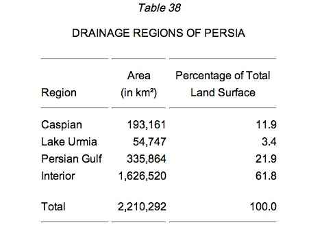
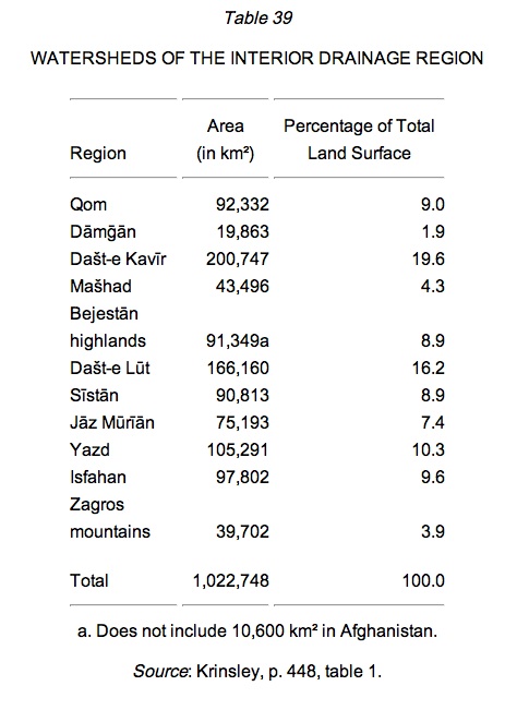
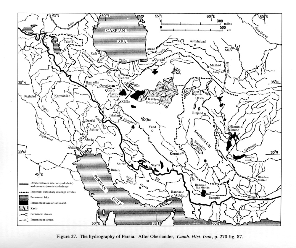
Persia can be divided into four main drainage regions (for terminology, see Krinsley, p. 32): the Caspian region, the Lake Urmia region, the Persian Gulf region, and the interior (Table 38). The Caspian drainage region encompasses a narrow zone along the southern coast of the Caspian Sea. Of several hundred mainly minor tributaries only a few catchment areas have longer extensions, for example, the Safīdrūd in the southwestern part of the Caspian basin and the Atrak river in the Dašt-e Gorgān. Although classified as an exterior drainage basin, the Caspian is itself endorheic, with no outlet to the oceans. Lake Urmia is also endorheic, forming a body of water 4,000 km2 in the spring but varying with the seasonal discharge rates of its main tributaries, the Talḵarūd and the Zarrīnarūd. The Persian Gulf system is by far the most important single drainage system of Persia. Covering more than 350,000 km2, it drains the western Zagros mountains, with its large watersheds, characterized by extremely complex geomorphology (Oberlander, 1965); snows are retained in the valleys through the winter, and in the spring permanent streams from the Zagros may carry a volume of runoff ten times greater than the minimum discharge in late summer (Oberlander, Camb. Hist. Iran, p. 267). The Kārūn river, one of the largest in Persia, and some of its tributaries are examples of such annual variation. The interior drainage region is the largest in Persia; because of its particularly complex geomorphic structure, it can be subdivided into eleven watersheds, some of which extend across national boundaries (Table 39). The watersheds themselves are further divided into basins, for example, the Dašt-e Kavīr and Dašt-e Lūt (Table 39, Figure 27). Almost all the Persian watersheds are drained primarily by intermittent streams; only the Zāyandarūd, the Helmand, and some smaller streams are permanent, discharging their waters into intermittent lakes or interior basins.
Altogether the Persian drainage system reflects the ecological differentiation of the country (see ECOLOGY). Surface runoff is used to a large degree for irrigation, and peripheral regions are thus more favored. Agriculture in Gīlān and Māzandarān, as well as in Ḵūzestān and in the garden belt around Isfahan, would be impossible without the availability of sufficient surface water. Surface drainage is also important for the development of hydroelectric power. Only permanent streams and their catchment areas in the Alborz and the western Zagros receive enough runoff to provide suitable sites for construction of dams for energy and irrigation. One important aspect of drainage systems, that is, navigability, is totally absent from Persian streams, with the esception of the lower sections of the Arvandrūd up to Ḵorramšahr.
See also ĀBYĀRĪ; AGRICULTURE.
Bibliography:
(For cited works not found in this bibliography, see “Short References.”). D. B. Carter, C. W. Thornthwaite, and J. R. Mather, “Three Water Balance Maps of Southwest Asia,” Laboratory of Climatology, Publications in Climatology 11/1, Centerton, N.J., 1958.
D. B. Krinsley, A Geomorphological and Climatological Study of the Playas of Iran, U.S. Dept. of the Interior, Geological Survey, Washington, D.C., 1970.
T. M. Oberlander, The Zagros Streams, Syracuse, N.Y., 1965.
Idem, “Hydrography,” in Camb. Hist. Iran I, pp. 264-79.
Figure 27. The hydrography of Persia. After Oberlander, Camb. Hist. Iran, p. 270 fig. 87.
Table 38. Drainage Regions of Persia.
Table 39. Watersheds of the Interior Drainage Region.
(Eckart Ehlers)
Originally Published: December 15, 1995
Last Updated: November 29, 2011
This article is available in print.
Vol. VII, Fasc. 5, pp. 526-529
Eckart Ehlers, “DRAINAGE,” Encyclopaedia Iranica, VII/5, pp. 526-529, available online at http://www.iranicaonline.org/articles/drainage (accessed on 30 December 2012).