


Before the period of war and unrest in Afghanistan that started in 1978, almost all the functions concerned with governing the country and directing its international relations were concentrated in Kabul. This primacy among Afghan cities is due to an exceptionally favorable geographical site, which showed itself to advantage at the precise historical moment when the first Afghan state, founded in the 18th century, located its center of power there.
LOCATION AND EARLY HISTORY
The Hindu Kush passes and the Kabul basin. The major obstacle formed by the great Hindu Kush range lying between lower Central Asia and India can be satisfactorily crossed only at a few points. The approach to Kabul from Balḵ, which used to be the main center of the northern foothills, presents two choices. One is the Sālang pass route—the pass itself or the 3,337-meter tunnel. The other, to the west, and more accessible in winter because of the lower altitude, is the road through the Āq-Rebāṭ pass, the Bāmiān basin, the Šibar pass (at 2,987 m), and the Ḡōrband valley. Both routes converge toward the confluence of the Sālang and Panjšir river valleys, where the latter provides another access northward across the mountains by way of the Ḵāwāk pass. The southern foothills of the Hindu Kush here are occupied by a large basin, at an average elevation of 1,800 meters, which slopes slightly southward, where it is drained from west to east by the Kabul river. The latter, with its tributary, the Lōgar, collects the waters of the northern slope of the Paktiā ranges before opening a route to the Jalālābād basin and the Khyber pass. These, in turn, provide direct access to the central basin of the Indus and all of northwestern India. This route from Bactria to Taxila, “the old road to India” (Foucher, p. 47) long before the area became Muslim, was always a main link between Central Asia and the subcontinent. It offers far more rapid and satisfactory passage to the Indus than the complicated passes across the Solaymān mountains, which rise to the southwest. The route farther to the west, by way of Mary (Marv), Herat, Farāh, Qandahār, and Quetta, offers the advantage of rounding the Hindu Kush and its western extension, but it is much longer and leads through almost desert-like areas. On the other hand, there is plenty of water and food along the eastern route, which cuts through the best-watered and most fertile regions, and where the Kabul basin forms a particularly pleasant resting-place.
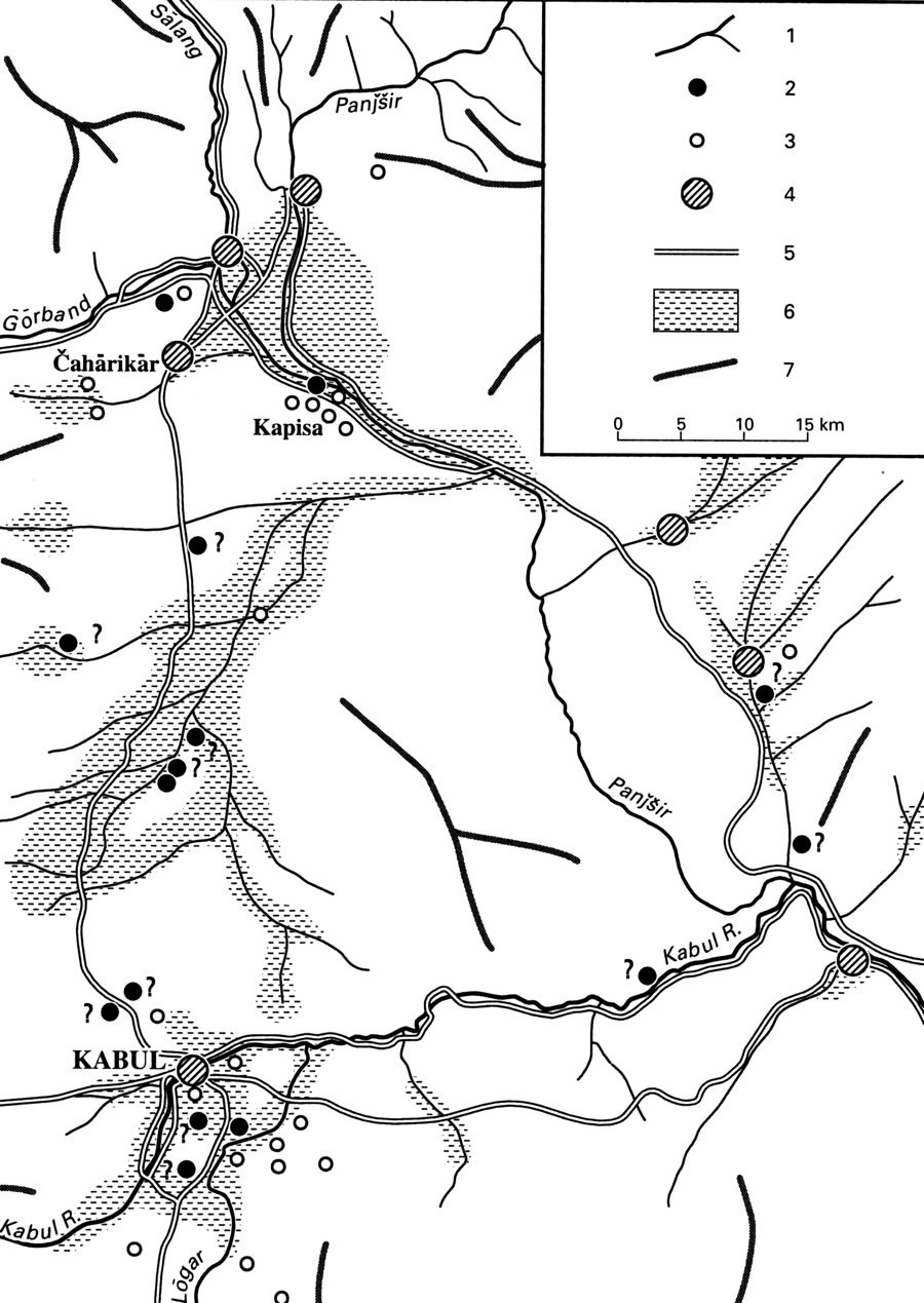
The urbanization of the basin: from Kapisa to Kabul (Figure 1). This major communications node was bound to become a busy center of urban life, but where would the settlements be located? Logically they should have been built at the edge of the plain, overlooking the outlets of the great valleys and, if possible, their confluences. From this point of view, there are two suitable sites: in the north, one controlling access through the basin north and northwest via the Panjšir and Ḡōrband valleys to the Sālang, Šibar, and Ḵāwāk passes; and in the south, where the Kabul river, after receiving the waters of the Lōgar and the Panjšir, opens a breach in the mountains towards the Jalālābād basin. Both localities were occupied by humans at an early period, but their respective importance has varied considerably through time.
The earliest urban development took place on the northern side. At the time when Alexander’s conquests united the two slopes of the Hindu Kush into one empire (329 BCE), the main settlement was situated north of the basin, on a terrace about 15-20 meters high, overlooking the alluvial bed. This was Kapisa (Katisa in Ptolemy, Geographia 6.18; Sk. Kapiśa, Chin. Ki-pin), ca. 15 km from the edge of the basin, which commanded the confluence of the Ḡōrband and Panjšir rivers. Its importance is indicated by numerous Buddhist ruins. It appears to have remained the main center of the basin for a long time. But its site, on a plain that could not easily be defended, proved a disadvantage in the face of successive nomadic invaders arriving from Central Asia, from the Sakas and the Yuezhi who overthrew the Greek kingdoms of Bactria, to the Hephthalites, who supplanted Sasanian rule, to be followed by Turks and Arabs.
The major urban center tended gradually to migrate toward the south of the basin, which presented a more suitable defensive site. The Kabul river, flowing from southwest to northeast in this sector, here cut a deep, epigenetic valley within a rocky range 300 to 400 meters above the average level of the plain, between the two ridges of the Kōh-e Āsmāʾi (2,110 m) to the north and the Kōh-e Šēr Darvāza (2,222 m) to the south. Between the secondary ranges and the river, there was space sufficient for developing a village protected by the fortifications built on the heights, and particularly the Bālā Ḥeṣār, at the easternmost side of the Kōh-e Šēr Darvāza, which was to be the strong point dominating the city up to the present. To the north, the course of the Kabul river itself provided additional protection, while to the east there were marshy places making it difficult to approach. (On the geographic setting, see, e.g., Humlun; Hahn, 1964-65, I, pp. 9-18; Grötzbach, 1990.)
The urban center that emerged here for a long time competed with the northern one, and in fact it is unclear how the newer town came to prevail. Although the name of the Kabul river appeared very early in the sources, that of the city, in its definitive form, properly appeared only in the 8th century CE. The existence of one or several built-up areas at this site much earlier, however, is beyond doubt. Ptolemy (6.18.4) states that this region (the Paropamisadae [see GANDHĀRA]) had a town called Karoura (or Kaboura)—evidently a transcription of the local name. He cites another city at the same place: Ortospana, which Strabo (11.8.9) describes as being an important crossroad with three roads leading to Bactriana. Perhaps there was, as has been suggested (Berthelot, p. 290). a double city, on both sides of the river. The name appears again a little later, in the 5th century, in the Chinese sources, under the form Kau-fu, which is evidently a transcription of Kaboura. Also in the Chinese sources, the name of Gandhara before the arrival of the Hephthalites in the 4th century CE is given as Jep-poʿ-lo. J. Markwart (Ērānšahr, pp. 246-47) suggested derivation from a form *ǰābul or the like, representing “Kābul,” and cited Indian coins of about the same period carrying the title ṣāhi ǰawūwlaḥ/ǰabula, possibly “king of J.” In any case, there is no doubt that an important commercial center, perhaps the seat of a political power bearing the same name as the river, existed south of the basin at this period. But what were its relations with Kapisa, and what was the date of the transfer of power to the southern town?
It is still impossible to provide a precise answer to this question, which can only be solved by archaeology, but it is certain that this transfer took place shortly before the settlement of the first Muslim armies in the region. During the 1st-2nd centuries CE, the city of Kapisa (see BEGRĀM) was the seat of the summer palace of the last Kushan kings (Fraser-Tytler, p. 21). For the time of the Hephtalites (4th-5th cents. CE), there is no certain way to find out the respective situations of the two urban centers, but the fact that Fa-Hsien, in the early 5th century, mentions only Kapitha is an indication that Kapisa’s predominance continued (Fa-Hsien, p. 24). As late as the mid-7th century, we may gather from Hsuan-Tsang’s text that the main center was still situated there. On the eve of the first Muslim incursion, in 653-54, Arabs arriving from Sind found in Kapisa the seat of a kingdom of that name. A vassal of China, it was ruled by Hinduized Turks—the Turkshahi dynasty—who spent the summer in Kapisa and wintered in the Indus valley. But under them were numerous subject rulers, and there soon appeared a state centered on Kabul (ǰabula), which gradually gained in importance (Markwart, Ērānšahr, p. 289). From 720 on, the tekin of Kāwasān (Kušān) acknowledged the supremacy of the ruler there, and by 778-79 the latter’s Muslim envoy credited him with the title of šāh (Markwart, Ērānšahr, p. 291). Probably the superiority of the site of Kabul was confirmed in a troubled period when the region was a border zone, under the constant threat of Muslim troops. In the late 9th century CE, the Hindushahis reigned there. They had succeeded the Turkshahis in 850 and were subdued after 870 by the armies of the Saffarids (Bosworth, p. 35).
From the Tajik city to the Afghan capital. It would take a millennium beforethe urban concentration at Kabul, with its favorable natural conditions, acquired a major political role and ultimately became the capital of a state centered on the highlands and controlling access to India. During this entire period it continued to occupy a merely marginal position as a military base and frontier post, without any central function. During the early period following the Muslim conquest, it continued to serve merely as a distant support point for the Samanids (819-1005 CE), then for the Ghaznavids (977-1186 CE). The Ghaznavid center of power was situated some 200 km to the west, and the expeditions into India were organized from there. Kabul, although near the countries ruled by non-Muslims, was simply the seat of an important garrison and the army assembly point. For example, here in 1031 Sultan Masʿud reviewed 1,670 war elephants (Bayhaqi, ed. Fayyāż, p. 376; Bosworth, p. 116). Kabul’s role remained purely local under the Ghurids and the kings of Chorasmia, and also later, after its destruction by the Mongol armies, under the Timurids, whose authority was firmly established in Herat. For all these states, the center of gravity and interests lay exclusively on the plateau. Relations with north India, where the Sultans of Delhi asserted their independence from the early 13th century, were not a major preoccupation that enhanced the strategic value of Kabul.
Ẓahir-al-Din Bābor’s conquest of India in 1526 revealed, for a time, the strategic significance of Kabul. Once he had firmly established his rule in Delhi and Agra, he began, in the hot and humid torpor of the Ganges plains, to feel nostalgic for the city that he had seized in 1504 after fleeing from the Uzbeks. Kabul had been the starting-point of his fortunes, and he appreciated its rural environment and pleasant conditions. In his memoirs, he constantly praised the numerous advantages of this small city: “mountain, river, city, lowland in one” (Bābur-nāma, fol. 129a-b; tr. Beveridge, p. 202; Planhol, 1974, p. 157); “the citadel of Kābul . . . lying high in excellent air, and overlooking the large pool . . . and also three meadows . . . a most beautiful outlook when the meadows are green” (fol. 128b; tr., p. 201); its “very pleasant climate; if the world has another so pleasant, it is not known” (fol. 129b; tr. p. 203). He had a magnificent garden laid out on the slope of the Šāh-e Kābol (also called Šēr Darvāza) hill, where he wanted his tomb to be built (Bābor-nāma, tr.’s note, pp. 710-11; Burnes, I, pp. 141-42).
The sovereigns of the dynasty of the Great Mughals were as fond of the city as their ancestors had been, and one of the young princes often stayed there. It was difficult, however, for them to govern an immense empire extending far into the subcontinent from this remote outpost of their possessions. Under their rule, Kabul played a purely military role as the base of their operations against the Safavids and Uzbeks, from whom they claimed respectively Qandahār and Badaḵšān.
Throughout the medieval period, however, Kabul continued to carry out the important commercial function that its geographical position dictated. Already in the 9th century, Yaʿqubi (Boldān, p. 291; tr. Wiet, p. 106) noted that it was frequented by merchants, who exported from there a regional specialty—myrobalan (ahlilaj), a kind of condiment made of fruits and dried grains, which was astringent and much used in Muslim medicine. In the 10th century, the description provided by Ebn Ḥawqal (p. 450; tr. Kramers and Wiet, pp. 435-36) presents it as a major center of caravan routes, with busy markets and warehouses, where several communities coexisted. Muslims, Jews, and Hindus lived in their separate quarters in the suburbs, while only Muslims lived in the city proper. The Hindus, whose presence is constantly mentioned by the sources (e.g., Ḥodūd al-ʿālam, p. 104; tr., p. 111; comm., pp. 346-47; Eṣṭaḵri, p. 280; Moqaddasi, p. 304) and who were evidently characteristic of the city, imported the products of their own country, above all indigo, of which Kabul was the great center of distribution for the Muslim countries of the Middle East. The city was also the center of a textile industry, producing cotton fabrics and expensive handkerchiefs and scarves that were exported to Sind and to Khorasan and as far as China. This rich, industrious city may for that period be included within the list of the forty-four most important cities of the Muslim world (Miquel, IV, p. 204).
This picture clearly changed after its destruction by Čengiz Khan’s armies in the early 13th century. Ebn Baṭṭuṭa, who visited the city in the 14th century, found it reduced to the rank of a simple village inhabited by a tribe of Persians called “Afghans” (tr. Defrémery and Sanguinetti, III, p. 89), which apparently implies that the Pashtuns had settled there in the ruins after the massacre of the population of Tajik artisans and traders. The advantages of the city’s geographic position, however, were substantial enough to bring about rapid revival—already by Bābor’s time (early 16th cent.), when the city was again active and its commerce was thriving. It was possible to buy merchandise coming from Asia Minor (Rum), Iraq, Khorasan, and China. Caravans converged there from all parts of Central Asia: Kāšḡar, Farḡāna and Turkistan, Samarqand and Bukhara, Badaḵšān, Balḵ, and Ḥeṣār (Šādmān in Transoxania). Kabul was “Hindustan’s own market,” where 8,000 to 10,000 horses were collected each year destined for India; and from the subcontinent arrived caravans of 10,000 to 20,000 merchants bringing slaves, white (cotton) fabrics, raw and refined sugar, and spices. This trade brought in considerable profits, on the order of 300 to 400 percent (Bābur-nāma, fol. 129, tr., p. 202). In its relations with India, Kabul was considerably ahead of its only competitor, Qandahār, which dealt in little more than merchandise from neighboring Khorasan.
How then did this purely commercial center finally manage to acquire political leadership? The emergence of a power center within the Pashtun tribes in the early 18th century did not itself alter the destiny of this Tajik city. The first Afghan state was built from Qandahār, at the heart of the Pashtun country, and was oriented initially toward the conquest of Persia rather than of India. After the Afghan incursion into Persia (1722-27; see ḠILZI) was repulsed, Nāder Shah Afšār (r. 1736-47) eventually turned to his eastern frontiers. He seized Kabul in 1738 on his way to invade India and, on his return, settled there a Persian garrison of about 3,000 men, the Qizilbash (Qezelbāš, Tk. Qızılbaç: the name applied to the Shiʿite Turkoman tribes who supported the establishment of the Safavid state, and later to Shiʿite Turks generally). They were to mark the city profoundly, and traces of them are still discernible in the composition of the city’s population (Marvi, II, pp. 563-66; see below and AFGHANISTAN iv). Following the assassination of Nāder Shah (11 Jomādā II 1160/9 June 1747), Aḥmad Khan, who had served as the head of the Abdāli contingent in Nāder Shah’s army, was elected by a tribal council (Pashto jirga) as the king of the Afghans and was crowned in Qandahār in 1747 as Aḥmad Shah (r. 1747-72), Dorr-e Dorrān (hence the epithet Dorrāni; on him see AFGHANISTAN x).
The subsequent expansion of the first Afghan state into India to form a Dorrāni empire (1747-1826) was conducted from Qandahār, although it would clearly have been easier to control relations with the lowlands of India from Kabul. It seems that no such strategic vision led Timur Shah (r. 1773-93), the son and successor of Aḥmad Shah, to transfer his capital to Kabul in 1773-75; it was simply a historical accident in the time of troubles after the death of Aḥmad Shah in 1772 and the ensuing competition for the throne among his sons. The rebellion against Timur, Aḥmad Shah’s chosen heir, found abundant support from the Qandahār region and the neighboring tribes, while Timur relied on the originally foreign garrison of Kabul. With his fondness for tranquility, he naturally felt more secure there, even after his power was stabilized (Elphinstone, p. 559). It is not impossible that he also considered the ease of communications with India, but there is no supporting evidence. The move was, in any case, a decisive turning point for the city, which from then on never ceased to retain the country’s central leadership.
urban development
Beginnings: the period of instability (1775-1880). For more than a century Kabul was not able to derive any benefit from its new function to develop into a true center of political authority. The gradual diminution of the first Afghan kingdom began soon after the death of its founder. The transfer of the capital from Qandahār to Kabul alienated the Pashtun tribal leaders in whose territory Qandahār lay. There were uprisings in the north and northwest, and the rise of Sikh power in the south eventually forced the state, starting from the first third of the 19th century, to abandon its possessions in India to the Sikhs. In contrast to his father, Timur Shah did not designate any of his many sons to succeed him, which led to the rise of several pretenders to the throne, each representing a different tribal faction through matrimonial connection. There were also the two Anglo-Afghan Wars (1839-42 and 1878-80), the first of which caused a great deal of destruction in the city. The sovereign’s power was greatly curtailed at this time, and it was only with extreme difficulty that he could exercise any authority in Afghanistan beyond his capital. All these events long prevented the development of a true capital.
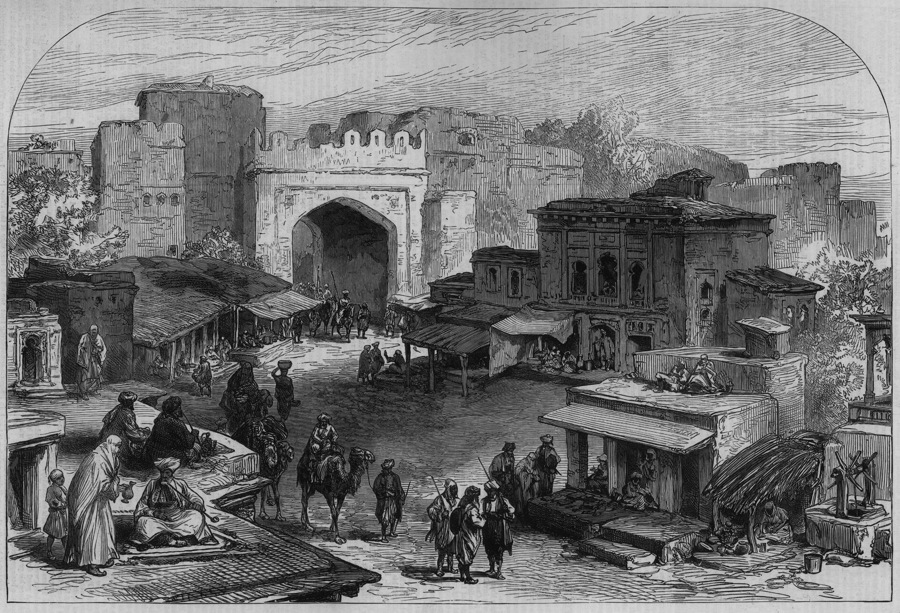
At the same time, however, the city received, from the installation of the court there, an important impetus to growth of population and commerce in the last quarter of the 18th century and the early decades of the 19th century. Descriptions by British travelers provide us with an idea of the appearance of the city and the activities there during this period (Figure 2). The most significant ones include the travelogues of George Forster (II, pp. 72-84; travel in 1785), Montstuart Elphinstone (pp. 601-2), Durie (travel in the early years of the 19th century; cited by Elphinstone), Alexander Burnes (I, pp. 133-70; II, pp. 334-36), Charles Masson (II, pp. 227-90; travel in 1831, residence 1835-38; an essential source), Godfrey Thomas Vigne (pp. 154-226, travel in 1835), and Mohan La1 (pp. 67-79, travel with Burnes in 1832).
The activity of setting up a court led to a large increase in population, which had already begun previously due to the strategic significance of Kabul as a point of departure for expeditions to India. The new arrivals included an ongoing stream from Persia, almost all of them Turkish-speaking, who came, sometimes in groups with their families, sometimes alone, to seek their fortune with the Pashtun dynasty. They were encouraged by the royal favor enjoyed by the Qizilbash (see above), who had remained in Kabul after Nāder Shah’s assassination and joined the service of Aḥmad Shah, who enlisted them in his guard. They became an essential instrument of the king’s power, beginning at the time of troubles that marked the accession of Timur (see above), who was suspicious of his own people and made the Qizilbash the basis of the troops to ensure his own safety.
This military role gradually declined in the early years of the 19th century. The Qizilbash then found other occupations, especially as secretaries at the service of the Pashtun princes. They spoke among themselves Turkic dialects more or less related to the Azeri group, and both Aḥmad Shah and Timur Shah spoke to their head men in their language. But many were well versed in Persian, and the general language of communication in the town was Persian. Qizilbash also worked as physicians and, more mundanely, in the city’s trade and industry. In the 1830s, their total number probably was 18,000 to 20,000, possibly half the total population (see below). As Shiʿites, a large majority of whom were members of Sufi brotherhoods, they formed an element quite distinct from the Tajik population, who were Sunnite and made up the original population base. Also present, but in much smaller numbers, were the Hazāras of the central mountains, who were likewise Shiʿites but followers of a popular religion without an organized hierarchy; they were attracted to the court to seek odd jobs. The Pashtun segment included the members of the ruling class and their dependents.
Non-Muslim communities were also present. There was a significant Armenian colony, joined by some Georgians (Forster, II, pp. 72, 77, 93; Burnes, I, pp. 148-49, 160; II, p. 331; Masson, II, p. 255). Their roots there were certainly old and connected with trade, but their number grew considerably in the reign of Aḥmad Shah. The latter had, during his expeditions in Persia, transported major groups of them to Kabul, especially from (New) Julfa (Pers. Jolfā; see JULFA), but also from Mashad, and had enlisted them, like the Qizilbash, in his personal guard (Forster, II, p. 93) They continued in favor in this employment until the reign of Timur, when they constituted about a hundred families. They suffered under his reign, however, from Timur’s neglect of his troops, and by 1783 they had fallen into a state of relative poverty. They nevertheless kept up a lucrative trade in wine and spirits, which they did not shrink from procuring for the Muslim inhabitants of the city, a traffic that they shared with some Jews. This trade continued until the day when Dōst Moḥammad Khan (first r. 1826-39), in the early years of his reign, apparently wishing to be forgiven for the debauchery of his youth, formally prohibited any trade of alcoholic drinks in his city, thus completely ruining their business. The community dispersed, and there remained merely twenty-one homes when Burnes passed through a few years later. The number of Jews had, for the same reason, declined to a mere three families by that time (Burnes, I, pp. 148-49; II, p. 331).
The Hindus, whose number depended on the trade with the subcontinent, appeared to have formed a more stable community. They were already numerous in 1783, having come mainly from Peshawar, and one of them served as Timur Shah’s treasurer. In the early 19th century, the high, wooden houses of the Hindu traders drew attention in the bazaar and displayed the prosperity of their group, which controled the major part of the fabric and cloth trade (Durie, apud Elphinstone, p. 602). In 1832, Mohan Lal estimated their number, with perhaps a certain exaggeration because they were his compatriots, at about 2,000, with shops in all the bazaars of the city. These figures are hardly compatible with the data provided by Vigne, according to whom there were only a small number of Hindus, who made a living mainly from moneychanging, for which they had no competition. It was, however, all the more difficult for Vigne to miss them, since their clothes and the painting of their faces made them quite distinct (Forster, II, pp. 82-83; Mohan Lal, p. 74; Vigne, p. 165).
As was the custom in Muslim cities, various nationalities were, for the most part, grouped each in its own quarter, and the whole city was neatly subdivided. The royal city—the king’s residence—occupied the lower slopes of the easternmost part of the Kōh-e Šēr Darvāza, below an old and already ruined fortification. This Bālā Ḥeṣār Pāyān quarter had about 1,000 houses, with an apparently very mixed population. Apart from the Qizilbash guards, there were separate quarters for the Arabs, the blacks (slaves or descendants of slaves), and the Armenian traders. Immediately outside of the palace, there was a special bazaar for supplying all this part of the population that revolved around the court (Masson, II, pp. 255-59). The majority of the Qizilbash, those who still lived grouped according to their divisions into clans, dwelt west of the city in the separate quarter of Čendaval, which was a simple village in Bābor’s time. Its own separate wall fell into ruins in the first half of the 19th century. It had a bazaar and comprised 1,500 to 2,000 families, according to some (Masson, p. 260), 2,500 according to MacGregor (p. 529).
A sizeable number of the Qizilbash, about 1,500 families, were non-tribal and lived mixed with the native Tajik population in the old city. This area extended from the Kabul river to the foot of the royal quarter and numbered about 5,000 houses. It had an important bazaar of the “bazaar-street” type, with shops stretching along the two main roads, which were more or less parallel. A more structured section had arcades surrounding a square space opening onto four perpendicular streets in the manner of Central Asian bazaars. Unlike the latter, the old city bazaar was open to the sky and not covered by a set of domes. Its construction was attributed to ʿAli Mardān Khan, the governor at the time of Jahāngir (r. 1605-27). The bazaar expanded, especially after the advent of the Pashtun dynasty, reflecting the growth of the town at this period. In the 19th century it had about 2,000 shops (Burnes, II, p. 335) and about fifteen serais (caravansaries, warehouses), some of which had been built in Timur’s reign by foreign merchants, who used them as their residence (Forster, II, p. 73). The old city was no longer surrounded by walls in the early 19th century, a sign of the security provided by the Pashtun dynasty.
Several suburbs had developed on the northern bank of the river by this time and were connected to the city by a number of bridges or wooden gangways (Masson, II, pp. 263-65; MacGregor, pp. 422-23), which often were in a deteriorated state and more or less repaired. These northern suburbs were inhabited mainly by newly arrived Pashtuns. Descendants of the earliest Qizilbash to arrive (at the time of Nāder Shah) also occupied a separate fort three miles from the city.
Our only sources about the size of the city’s population are the memoirs of Western travelers. Burnes’ estimates of 60,000 (I, p. 147), accepted by Vigne (p. 165), and Masson’s of 50,000 to 60,000 inhabitants (II, p. 260), followed by MacGregor (p. 422), were based on an estimate of 9,000 to 10,000 houses. These figures, however, seem somewhat high. The area of the old city could not have been over 50 sq ha (Forster, p. 79; he estimated the circumference of the wall at about 1.5 miles), and it is hard to admit that it could actually have contained 5,000 houses. A figure lower than 50,000 inhabitants appears more likely and would come closer to the estimates regarding the Qizilbash, who formed “more than half of the population” (Masson, II, p. 260).
It appears, in any case, that all the elements of this very diverse population were on good terms with one another. Travelers unanimously pointed out the general atmosphere of religious tolerance “to a degree that was rarely seen in a Muslim country,” as well as the civility in relations between different groups, with no prejudice and no sort of fanaticism (Forster, pp. 77, 100; Mohan Lal, p. 74). Even when there were some political difficulties between the Shiʿites and the Sunnites, or between Shiʿites from Kabul and Hazāras, everyday relations among various communities continued as usual without being affected (Masson, II, pp. 298-99). This feature contrasted with the well-known crudeness of the Pashtun tribes. Kabul left on all visitors of the period an impression of amiable cosmopolitanism, which expressed the concept of the first Afghan kingdom.
This feeling of congeniality found expression in the festive habits of the city and in the profusion of gardens, which were regularly visited. Many of them were private properties, but they were always open to the public (Burnes, I, pp. 151 ff.; Vigne, pp. 175 ff.; Masson, II, pp. 280-86). The price of this joie de vivre was, however, a certain moral laxity, an “immorality” that became notorious. The women of Kabul had a bad reputation. “The flour of Peshawar is not without a mixture of barley, and the women of Kabul are not without lovers” (Mohan Lal, p. 73), said a proverb. The morals of the Qizilbash were particularly disparaged both for their wine drinking and their women’s lack of virtue (ibid.). It appears evident that this community of uprooted mercenaries, whose role had been decisive in the population’s makeup, lent the city its tone. As lovers of wine, gardens, and various kinds of pleasure, the people of Kabul might at the time have been considered “a holiday people” (Masson, II, p. 280).
The city, nevertheless, was busy and industrious; trade and crafts, more than court service, formed the basis of prosperity as the Dorrāni empire flourished. The economic role of the town evidently benefited greatly from its new political status as the capital city (MacGregor, pp. 424-23; an essential source based on an unpublished report by Masson). In this humble Tajik village that had grown to become the capital of an extensive empire, new techniques and occupations began to flourish. A period of intense innovation in crafts ensued, mainly under Persian influence. The quality of this small provincial city’s products was very mediocre in the beginning. “There is not a single article made and produced in Kabul that is not surpassed by those of other countries,” was the written opinion at the time (Masson, p. 289; Masson in MacGregor, pp. 423-24), and all of it was destined for the lower classes.
The presence of the court created needs that people tried to satisfy partially through local production. A silk industry was created in the city for the first time in about 1815 by Maḥmud Shah b. Timur (r. 1809-18), whose patronage attracted Persian artisans from Herat. It was successful, and by the 1830s there were already eighty-eight active looms in the city (Masson in MacGregor, p. 427). At the same time there was an attempt, again by Persians, to develop manufacturing of glass for bottles, drinking glasses, etc., but its success was still incomplete a few years later and its quality “just merely acceptable” (Masson in MacGregor, p. 428). Sugar and sweets were also produced in Kabul from sugar cane of the Jalālābād region, but these products remained very inferior in quality compared to those of India (Masson in MacGregor, p. 428). The local craft industry, on the whole, produced only very simple objects, and all articles of a superior quality had to be imported. For example, Kabul had to import various iron manufactures, such as weapons or wire, even though it smelted iron from the local mines into bars.
External trade was thus definitely unbalanced. Kabul at the time exported hardly anything beyond the same products that had always formed the basis of its trade with India, including horses (a large number of which came from Central Asia and were only in transit), raw hides, and dried fruit. To Qandahār it exported regional products, including iron bars, hides, and lamp oil, and received in exchange large quantities of good-quality melons, as well as products coming from Persia (Forster, p. 82). The existence of the court turned the city into a great center of consumption, for which the supply network extended to India, on the one hand, and Russia, by way of Bukhara, on the other. The competition for supplying the Kabul market in the first half of the 19th century posed interesting problems.
The import trade from India was still very active in the second half of the 18th century, when Kabul was largely supplied with cotton and various other fabrics through the Khyber pass and from Peshawar (Forster, p. 82; Durie in Elphinstone, p. 602); but it considerably declined in the early 19th century. This was due to the diminishing of Afghan possessions in the subcontinent, and especially to bad relations between the Kabul government and the Sikh empire, which preempted it in northwestern India. In the years 1820-30, the only really active trading activity between the Sikh domain and Kabul was carried out by the large annual caravan of the Lohāni (MacGregor, pp. 586-88), a commercial branch of the powerful Pashtun tribe of the Powinda. They wintered in the middle and lower Indus valley, purchasing merchandise in the bazaars of Lahore and as far as Varanasi (Benares). They then summered in the highlands of Afghanistan around Ḡazni and profited by reselling the merchandise in the kingdom of Kabul. They left the lowlands in April and returned in October. Scattered in both winter and summer along the route, they reassembled for their migration to form a powerful caravan that might number 600 to 700 camels and several thousand people (Mohan Lal, p. 76). This was done essentially for security reasons, for during their journey they were constantly exposed to attacks by Waziri looters, who plagued them whenever they could. This happened especially when they crossed the Solaymān mountains, which they did by way of the Gōmal valley and pass, before the road became safer towards Quetta and Qandahār.
It was only through the Lohāni that there arrived in Kabul an appreciable quantity of merchandise from India and that, in the 1820s and 1830s, commodities reached Afghanistan from Great Britain. These objects, conveyed via Bombay, were mainly luxury fabrics and high-quality cotton, copperware, fine cutlery, quicksilver, sugar, and sweets. This long and dangerous itinerary could not seriously compete for the Kabul market with the northern route, where, despite the crossing of the Hindu Kush, there was total security. Only the Lohāni, who were both soldiers and caravan leaders, ventured the southern route in large numbers, thanks to their clan-like solidarity (Masson in MacGregor, p. 431).
The imports that arrived in Kabul from the north included not only products from Central Asia, but also objects in transit through Bukhara, coming from China, Russia, and even from the rest of Europe. The paradox was that British merchandise also arrived in Kabul by this route transshipped through Saint Petersburg. Imports of luxury fabrics (silks, velvets, and satins), silver and gold objects, elaborate metal products (steel, iron and copper wire, pins, and objects made from copper and brass), and mercury sent by the northern route competed with those of the south. The north, however, had a real monopoly of certain products. Thus, all the paper used in Kabul arrived from there, as well as material for red dye (cochineal), while indigo continued to come from India (Masson in MacGregor, pp. 426-29).
The merchants of the Kabul bazaar had agents much farther away than Bukhara, as far as Orenburg and Astrakhan. From China came ceramics and tea, the latter becoming increasingly popular in Afghanistan. On the whole, the predominance of these northern products was obvious in Kabul, and was continually confirmed (ibid.), during the early period of Moḥammadzāy rule (1826-1973). Indeed much of the merchandise transported by the Lohāni, such as copper products from Bombay, could no longer compete in Kabul with those of the northern route and no longer went any farther than Qandahār (ibid.). Thus Kabul lost all the strategic advantages derived from its relative proximity to India, which had enabled it gradually to outstrip Qandahār at the time of the Dorrāni empire. This led to a period of relative stagnation in the city that was to last for half a century.
This situation continued, and became worse, after the First Anglo-Afghan War (see ANGLO-AFGHAN WARS) and the destruction of the Kabul bazaar; it was burned in 1842 by the British punitive expedition in retaliation for the massacre a year earlier of the retreating British garrison of Kabul. However, there is not enough information about the evolution of trade during the forty-odd years between the two Anglo-Afghan wars, since no British observer could enter Kabul during this period. All we know is that the commercial activity of the Lohāni continued, but its intensity is difficult to assess. The bazaar was gradually rebuilt after the departure of the British troops, in accordance with a plan that gave it an appearance hardly differing from the preceding one (Hensman, pp. 66-67); and the covered sector was restored, apparently as it had been before, by Amir Dōst Moḥammad Khan around 1850 (Gazetteer of Afghanistan VI, p. 329).
The city’s population in the late 19th century is difficult to estimate. According to the census taken by the order of the Amir Šēr ʿAli in 1876, the total population amounted to 140,700 inhabitants (including 103,000 Kabulis, 12,000 Tajiks, 4,000 Hindus, 3,000 Kashmiris, 6,500 Qizilbash, 5,000 Pashtuns, and a very small number of Armenians and Jews; see Gazetteer of Afghanistan VI, p. 33). It appears difficult, however, to accept this figure as that of the city alone, in terms of the estimates provided both for the previous period (see above for the 1830s) and for the following one (see below for the period of World War I and the 1920s). It is probable that the census of 1876 applied to the entire district (not differentiated from the city, according to an established custom in Muslim sources; Grötzbach, 1990, p. 37) and that the population of the city proper had hardly varied since the 1830s. An observer who had arrived with the British troops in 1879 (Hensman, p. 66) provided a plausible estimate of 70,000 inhabitants for 23,000 houses.
the beginnings of urban expansion
The new royal quarters (1880-1930). The last two decades of the 19th century marked the real unification of Afghanistan, both as an organized state and as a fully controlled one, by the strong grip of Amir ʿAbd-al-Raḥmān (r. 1880-1901; see AFGHANISTAN x). From then on, the authority of the Amir of Kabul over the territory remained uncontested. For a long time to come, however, the part played by the city remained almost exclusively political and military, while its economic and social hold over the rest of the country remained weak. The half-century following the accession of ʿAbd-al-Raḥmān was unquestionably a period of expansion for the city, but growth came about largely through the establishment of a supreme and efficient authority, a new power that expressed itself in the urban fabric. The concrete expression of power was to be the building of a new royal residence, taking the form of a quarter separated from the old one.
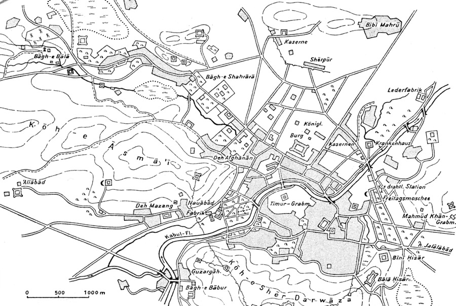
Two projects, undertaken forty years apart, endeavored to develop this idea, although in very different ways and with very unequal results. The first was initiated by ʿAbd-al-Raḥmān, who, immediately after his accession to the throne, decided to abandon Bālā Ḥeṣār and transfer his residence, with all the trappings of royal power and the military forces connected with them, to the north of the river. Bālā Ḥeṣār had been partly destroyed by an explosion of the arsenal during the British occupation of 1879 (Hensman, pp. 71-74). The British then planned to destroy it completely but did not have time to carry out their project; however, the site as a whole was in such a state of decay that the new king decided firmly to abandon this unattractive place (Hensman, pp. 78, 129). A large space was available north of the river among the hamlets and villages scattered around the plain. It was also easy to settle the troops in the broad cantonment of Šērpur, which Šēr-ʿAli Khan had built (Shadbolt, p. 62) a few years before the Second Anglo-Afghan War, not far from the site of the British cantonment during the first war (Eyre, pp. 30-34 and map). The new royal palace was built in a few years and was in use by 1888, although the harem then was not yet completely finished and occupied (Yate, pp. 361 ff.). About 800 meters from the river, the palace and a cluster of subsidiary buildings, within a complex of gardens, occupied a rectangular space enclosed by a simple mud wall. ʿAbd-al-Raḥmān himself approved the plans (Figure 3).
A great novelty desired by the sovereign was that all the government functions should be concentrated in the palace building or adjacent ones. Thus, offices were provided for numerous clerks, who previously worked in scattered locations, sometimes even in their own homes, so that their activities could not easily be coordinated. Nearby, a number of barracks and military installations were built, which were gradually followed by villas of dignitaries or members of the royal family, dispersed in a landscape which remained rural for a long time. The style of the buildings, which can be described as “Victorian,” broke completely with the Islamic tradition of the old city. This royal quarter was completed after World War I with the installation of embassies of foreign powers, which in increasing numbers formed diplomatic relations with an Afghanistan now (since 1919) totally independent from British control of its foreign relations.
The urban fabric became increasingly dense between the river and the new center of attraction thus created, as well as near the village of Deh-e Afḡānān to the west. Small neighborhood bazaars sprang up there, at first spontaneously, but then subject to formal planning early in the reign of Amir Amān-Allāh (r. 1919-29; see AFGHANISTAN x): two- or three-storey buildings, with the ground floors occupied by shops, were built along the river to replace older, more rudimentary structures (Hahn, 1964-65, I, pp. 24-26). In any case, Oscar von Niedermayer’s city plan of 1924 (see ibid.) based on data collected during the residence of the German military mission in Kabul in 1916 during World War I, already showed a dense and continuous urban fabric north of the river. This “new city” that was now juxtaposed with the old city was modeled after the ones that proliferated in Persia in the late 19th century and in the Arab Middle East under Ottoman domination. It was, however, much more modest than the latter.
Development north of the river remained slow and limited until the 1920s. This was consistent with the state of the country; it had not yet really entered into the phase of modernization and by no means functioned as a true unity (except for the existence of a superior political power), especially in regard to its economy. There was a deliberate process of a quite different scope inherent in the grandiose ambitions of rapid transformation that took root in the mind of Amir Amān-Allāh. No doubt like Amir-ʿAli and Amir ʿAbd-al-Raḥmān before him (Wild, p. 81), he was excited by the idea of creating a new “metropolis” to which his name would be attached, thus following a deeply rooted custom among Muslim sovereigns. In contrast to his predecessors, he acted. Amān-Allāh was deeply impressed by the example of Mustafa Kemal Atatürk, whom he greatly admired and whose policy of rapid westernization of Turkey, including the transfer of the capital from Istanbul to Ankara, he tried to imitate by a violent break with the old urban fabric. He chose an entirely new site on a plain with scattered hills about eight kilometers southwest of the old city, beyond the slopes of the Kōh-e Āsmāʾi and Kōh-e Šēr Darvāza, on the left bank of the river.
Here was rapidly constructed in the first half of the 1920s the building of the Dār-al-Amān quarter, which bore the name of its founder. The amir dreamt, above all, of building a healthy, airy city, far from the miasmas of the old town that he had vainly tried to have cleaned up and developed in the early years of his reign (Pernet, p. 26), a venture he had soon recognized as impossible. He wanted to make this new creation of his a “scientific” city, a model of organization and happiness (Fouchet, p. 43; Gregorian, p. 247). The plan was conceived by André Godard, a French architect who had previously worked in Persia; he was now in Afghanistan for the excavations for which the French archeological delegation (see DÉLÉGATIONS ARCHÉOLOGIQUES FRANÇAISES) had received the monopoly. It included, on the plain, a central traffic circle from which radiated six main avenues. Two hills dominated it, on the flattened tops of which the royal palace and the (intended) parliament building were erected. A broad, straight avenue with poplars on each side led to the old city of Kabul, which was also to be connected by a narrow-gauge railroad. This was the first railroad actually built in Afghanistan; the initial plan was to extend it to Jalālābād, which continued to be the winter capital (MacMunn, p. 307). By 1925, the foundations of the two palaces had been laid, and they began to rise on top of the two hills. At the same time, modern-type villas appeared along the avenues (Pernot, pp. 26-27). In 1928, the palace was practically finished, and Amān-Allāh, during his long tour of Europe, was busy buying furniture to decorate the interior (Fraser-Tytler, p. 211).
The rebellion of 1928-29 and the fall of Amān-Allāh interrupted this obviously premature dream (see BAČČA-YE SAQQĀ). When Nāder Shah (r. 1929-44) recaptured the throne in 1929, the royal power was again installed in the palace north of the river. Dār-al-Amān then became for a number of years a kind of phantom city, although its existing buildings were used for public purposes. In the 1950s, the palace became a hospital, and the intended parliament building became the Ministry of Labor. In the same period other buildings were allocated to the Ministries of Mines and Health, and newer agencies also came to be housed there (e.g., the Geological Service, the Hydrographic Service, the Bacteriological Institute, the Meteorological Institute). This lent the area, starting in the 1960s, the appearance of an annex of Kabul University, which rapidly developed at this time on the west side of the city. The university also completed the installation of Kabul Museum, which was regularly being enriched with finds—requiring much space—from the increasingly numerous archeological excavations. Dār-al-Amān, at first isolated due to its high-level activities, became progressively more urbanized and linked to the city center by several bus lines. During 1960-75, it finally became fully integrated into Kabul city, acquiring the aspect of a modern city quarter with a mixture of public buildings and fine residences. This happened half a century after Amān-Allāh’s visionary conception, which was evidently much in advance of its period but whose outcome was much more modest than the one originally envisaged.
The emergence of central functions (1930-80). After the failure of Amān-Allāh’s hasty and adventurous attempts in the 1920s, from 1930 on, a truly prudent and reasonable, and gradually more efficient, way was found to modernize Afghanistan. Kabul was the pole toward which Afghanistan’s movement toward modernization and innovation was oriented. It was also to be its first and principal beneficiary, receiving from the beginning the great majority of new urban infrastructure and attracting to itself the flow of a great mass of new inhabitants. It was gradually to acquire a growing and effective hold on large pieces of the broad territory that it theoretically ruled. The question remains whether, on the eve of the revolution of 1978, the dominance of Kabul actually rendered it the real control center of the Afghan space, one with an impetus that carried through the whole country. If so, one may still wonder how and in what stages this process of securing control took place. The numerous studies from the 1960s and 1970s (see Hahn, 1964-65, I, pp. 73-77; Barrat; Planhol, 1973; idem, 1995, pp. 665-69) permit one, without going into details, to be specific about the level of supremacy Kabul had reached by 1978.
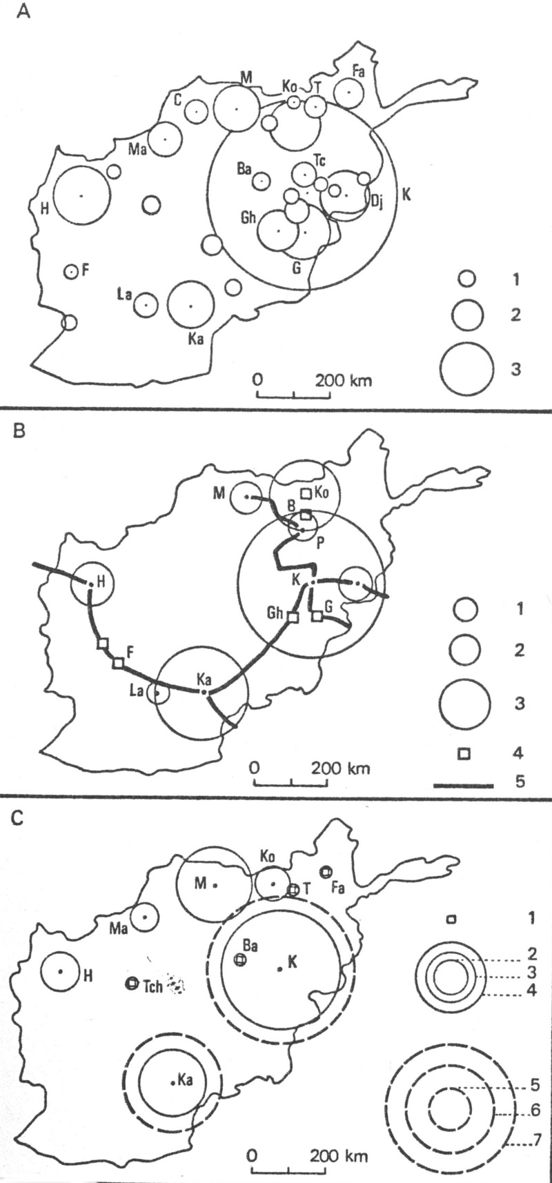
Only a very small number of Afghan cities had higher-level economic and administrative functions at the time, and Kabul’s privilege was overwhelming as far as urban facilitieswere concerned. The modern banking system was exclusively centered there. At Qandahār, Herat, and Mazār-e Šarif, it was possible to exchange foreign currency in the bazaar, but there was no banking activity properly speaking. Kabul also acquired branches of almost all the firms that were responsible for the country’s economic activity, except for the carpet trade in Herat and the karakul fur trade in Mazār-e Šarif. A graph of medical and hospital equipment (Figure 4, a) shows that in 1967 Kabul had 452 physicians out of a total of 527 in Afghanistan, and 1,322 hospital beds out of 2,217 for the whole country. University education was still entirely concentrated in Kabul in 1970, except for a medical institute in Jalālābād. In 1974, the number of students in higher education amounted to almost 8,000. Literacy among the city’s population was the highest in the country, at 26 percent—36 percent for men and 16 percent for women (Grötzbach, 1979, p. 50).
As for media, in 1968 Kabul had only six of the nineteen Afghan dailies, but their circulation was 70,000 copies against 33,000 for all the others. It also had thirty of the thirty-three weeklies and specialized periodicals (the other three were divided among Herat, Qandahār, and Jalālābād). For postal and telecommunications services, Kabul reportedly had about 5,000 telephones out of a total of 9,210 in the entire country (Figure 4, b). Such equipment then was found entirely in the towns on the northern and southern periphery of the central mountains, and connections between the northwestern plateau and the general network were very recent. Secondary connections covered only Qandahār and Herat. In 1977, the city had about four-fifths of the ca. 50,000 automobiles in the country (Grötzbach, 1990, pp. 143, 204). In short, Kabul alone was more or less the center for all technical equipment.
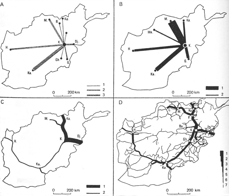
It is therefore no wonder that the analysis of traffic patterns showed that most of Afghanistan’s internal and external relations started and ended with Kabul, despite the clearly off-center position of the capital in the east of the country. The graph of airport passenger volume in the late 1960s (Figure 4, c) is highly significant. Despite the fact that during the winter many international flights were diverted from Kabul, whose airport was dangerous because of the surrounding mountains, to Qandahār, which was always accessible, Kabul remained the one and only hub of the international airlines. This emphasizes its exclusive role as the “door of westernization” for the whole of Afghanistan, a function that remained unchanged in 1978 (Grötzbach, 1990, pp. 143, 204). As for internal relations, no analysis of traffic flows toward the provincial towns was made at the time, but these were obviously insignificant in comparison with those directed at Kabul.
How were these inter-city relations organized? It seems that two types can be distinguished: (1) A certain number of relations proceeded from all the provincial cities towards Kabul, in proportion to their population and their importance but conditioned by their proximity. Postal links (Figure 5, a) belonged to this category: the flow from important cities such as Qandahār, Herat, Mazār-e Šarif, and the relatively close major provincial towns (Jalālābād, Gardēz), was considerably greater than from other places. Administrative relations, as well as cultural ones in all likelihood (e.g., university recruitment), belonged more or less to this type. The pattern of passenger air traffic must have been of the same type, but with an inverting factor: a tendency to a greater flow, the greater the distance. That factor, in turn, could be affected by geography. The route across the Hindu Kush was often blocked by snow in winter and therefore dangerous to cross in that season; this added considerably to the traffic from Mazār-e Šarif and Konduz to Kabul relative to the respective importance of these two cities (Figure 5, b).
(2) A second type of geographical disposition was particularly evident for the road network (Figure 5, c, d), which lies transverse to the central-eastern Hindu Kush and runs roughly north-south; it connects Kabul with the Pakistani border on one end and the cities of Turkistan and the former Soviet frontier on the other. Here the country’s great economic axis was situated, with the industrial centers on either side of the “water tower” of the eastern Hindu Kush, and along it the most active commercial relations with foreign countries. The road to Qandahār and Herat, which runs parallel to the mountains, remained fairly inactive despite the existence of a modern trunk road of great capacity (seemingly quite disproportionate to existing need), and these cities continued to appear like distant, marginal oases. Qandahār and Herat could to some degree be considered as secondary capitals, but they did not have the active economic relations with Kabul that their population and the relative importance of their urban facilities would suggest. On the whole, Kabul in the 1970s was still far from being truly the hub all of the country’s activity.
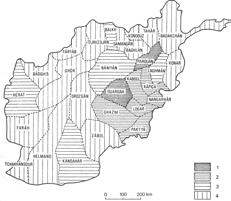
The incomplete nature of this domination of the Afghan space is indicated, in the same period, by the geographical dispersion of the recruitment pool for the city’s population. A survey of the geographic origins of 122,000 inhabitants of the city was carried out by the Ministry of the Interior in 1965 (Barrat). The two maps that show the survey results (Figure 6 = Planhol, 1973c, p. 196, reproduced in Planhol, 1993, p. 669; Grötzbach, 1990, p. 48, following the Survey of Progress, 1967-68, p. 32) differ slightly, due to the selection of different data segments. But both indicate that the pool of demographic attraction to Kabul found a natural limit to the north in the Hindu Kush barrier and remained essentially localized in the southeastern part of the country. The city’s ‘drainage area’ was primarily the provinces on the southeastern slopes of the mountains, and also the mountain valleys likewise on the southern slopes. These extend into the heart of the mountains only up to the Hazāra country (the province of Bāmiān), from which massive emigration to Kabul started from the time when Amir ʿAbd-al-Raḥmān conquered these highlands in the 19th century. Their arrival in the 1960s reinforced a presence that had already long been felt in the city (see above).
Attraction to Kabul remained insignificant for the rest of the country. The provinces of Qandahār, Herat, and Balḵ (Mazār-e Šarif) were exceptions, indicating emigration to the capital, though in a rather low proportion, from populations already urbanized in these large provincial cities. Kabul was not yet a center of demographic focus for the country as a whole, and that included the provinces of Turkistan on the northern side of the Hindu Kush. The Turks established in Kabul still numbered no more than 3,000 or 4,000 in the 1960s (Balland), and the opening of the road through the Sālang pass in 1964 was too recent to have had any demographic effect. It is probable, although information is lacking, that the development of economic ties and closer road links across the mountains is indicated for more recent times by increased human migration from the north. This phenomenon had not yet affected the life of the Kabulis on the eve of the communist revolution in 1978 (see COMMUNISM iv) and the civil war.
GROWTH OF THE POPULATION
The cultural challenge. Flows of immigrants, coming essentially from the southeastern part of the country, changed Kabul, beginning a half-century ago, into an imposing metropolis (data summarized in Grötzbach, 1979, p. 46). We have seen above how difficult it is to estimate precisely the population at the time when this change began. Niedermayer (p. 20) stated 60,000 inhabitants for 1916, but merely reproducing (without update or critique) estimates going back to the British sources of the 1830s. New estimates were made only toward the end of Nāder Shah’s reign (r. 1929-33) and appeared in 1936, but they were of local origin and carried out by the recent Afghan administration (reprod. in Hahn, 1964-65, I, p. 45; Humlun, p. 131, citing Ahmad and Aziz, and ʿAli). These stated 120,000 persons, a plausible figure implying that the population had almost doubled after more than a half-century of urbanization, from the accession of Amir ʿAbd-al-Raḥmān, and had considerably increased under Amir Amān-Allāh.
Some 20 years later, relying on oral information that he collected during his stay in the city and without a precise basis, Johannes Humlum (p. 132) raised the number to 250,000 inhabitants. In contrast, a relatively serious sampling by a service of the United Nations in 1954 stated 172,000 permanent inhabitants, to which were to be added 37,000 soldiers, students, and other transient elements. A few years later, two parallel updates of these figures, taking account of the growing birth rate of 1.75 percent per year and of the annual immigration of 3 percent per year, after a quarter by quarter survey of the city (the first ever published), reported respectively 223,000 and 230,000 individuals for 1960, without counting the approximately 40,000 non-permanent inhabitants (Hahn, 1964-65, I, p. 46). The population had again doubled, this time within a quarter of a century. It was next going to quadruple in the course of the two following decades.
From this point on, the order of magnitude in the reports became reliable, and new data rapidly followed (see CENSUS ii). A “census” in 1965 was very open to criticism, and the reliability of its figures as a whole was questioned, but it provided at least an approximate figure. It stated 435,000 inhabitants for “Greater Kabul” (including the neighboring villages and Dār-al-Amān, which was not yet included within the city area) and 290,000 for the city proper. This census was based on a questionnaire that revealed that more than a quarter of the inhabitants of Greater Kabul (i.e., 122,000 persons) had been born outside the city. Of these immigrants, 19,500 had arrived less than a year before, 44,000 from one to four years before, and 54,000 five or more years before (the rest of the sample provided no answer). Taking account of the fact that a certain number of immigrants subsequently left the city, this leads us to establish the annual rate of immigration at about 3 percent, thus raising the overall growth of the population somewhat above the ca. 2 to 2.5 percent resulting from surplus births. Later estimates, extrapolating from the census figures of 1965 on these bases (by admitting a global growth rate of 4.5 percent, which is probably underestimated), raised the population of the town to 675,000 persons in 1976 (Grötzbach, 1979, p. 46). The general census carried out in 1979 (which was probably also underestimated) stated 913,000 inhabitants for Greater Kabul (Grötzbach, 1990, p. 199). The figure must have approached one million inhabitants ca. 1980.
This growth, as well as the abovementioned geographic situation of the recruitment pool, deeply influenced the city’s ethnic aspect, which the preceding 150 years and the political role of the capital had hardly changed. The census of 1876 showed the overwhelming superiority of the local Persian-speaking and Sunnite population, while it also took account of non-native elements mentioned above—Qizilbash, Pashtuns, a small number of Hazāras, Hindus, and Armenians, plus about 3,000 Parāči-speakers, of whom there were more in the area than are found today. The population was differentiated according to purely social criteria. Of the 140,000 inhabitants of the district in 1876, there were 12,000 Tajiks and 103,000 Kabulis. The first designation applied to villagers living relatively far from the town, conscious of a particular identity that was different from that of the city, and regarding the others, that is, the city dwellers of mixed origins, with a certain feeling of superiority. They were happy to marry the latter’s daughters, but reluctant to marry off their own daughters to them (Gazetteer of Afghanistan VI, p. 333). We have no precise 20th-century estimate of the ethnic components of Kabul, since this politically explosive subject was never mentioned in the questionnaires of later surveys. The considerable increase in the number of Hazāras in Kabul in the 20th century, who left their very poor highlands for the city’s great labor market, posed problems of a religious nature due to their being Shiʿite. In this matter, they assumed the declining role of the Qizilbash, who tended to merge with the mass of Kabulis. Since the Hazāra speak a New Persian dialect very similar to Kabuli Persian (see HAZĀRA iv), their linguistic assimilation posed no difficulty.
The major new factor appearing during the last century was the progressive rise in the number of Pashtuns in the city. Pashtuns had been living in the city for a long time, quartered within circles closely revolving around the court, the culture of which was exclusively Persian to the point that the last sovereigns (and especially Moḥammad-Ẓāher Shah, r. 1933-73) spoke Persian as their mother tongue. There were also Pashtuns, in the late 19th and early 20th century, living in villages on the outskirts of Kabul. The name of one of these is toponymic evidence of their presence—Deh-e Afḡānān (Village of the Afghans, that is, of the Pashtuns), situated northwest of the city on the left bank of the river. Beginning in the 1930s they appeared in massive numbers in the city itself, but their proportion of the population is not known. L. Dupree estimated in 1975 (p. 20) that speakers of Kabuli Persian (dari; see AFGHANISTAN v, sec. 2, and KĀBOLI) were slightly more than half, and speakers of Hazāragi about a quarter (probably a little overestimated), and speakers of Pashto another quarter. This estimate is plausible, although it is not based on any precise data. In any case, it was mainly from among the Pashtuns that the newcomers were recruited. The small city of the late 19th century with its homogeneous Persian culture became a metropolis, where the two major ethnic groups of the country confronted each another, at least virtually.
The conflict was still only potential. Although the Pashtuns, together with the dynasty, for three centuries dominated the political life of Afghanistan, Kabul remained a center of Persian culture almost exclusively. There the language of communication is the local Persian, with the city functioning as a center of assimilation for all the other elements of the population, especially the minority ethnic groups. The Turks gravitated toward Persian culture, since they had come from Balḵ, where Persian was the common ethnic language of communication, but assimilation was also, and especially, the case for the Pashtuns. The efforts of the Afghan government to promote Pashto (for instance, the establishment of a Pashto Academy in 1935, and the publication of grammars and dictionaries in an attempt to standardize the language) provoked mirth, but the situation contained the germs of a fearful and dramatic conflict to come, when the ethnic groups of Afghanistan, as yet with expression muted by concern for individual destiny within the framework of interest groups, should wake to a real national awareness. How could the country’s majority group, which was responsible for its genesis as a territorial entity, and which had always monopolized power, in the long run accept a low cultural status in its own capital, which was situated a mere thirty to forty kilometers from the linguistic border? However, the demographic balance on which this primacy rested was to be threatened during the wars of the Soviet occupation (1979-89) and thereafter between Mujahidin and Taliban; the consequences of these (see below) have made themselves felt particularly in the capital.
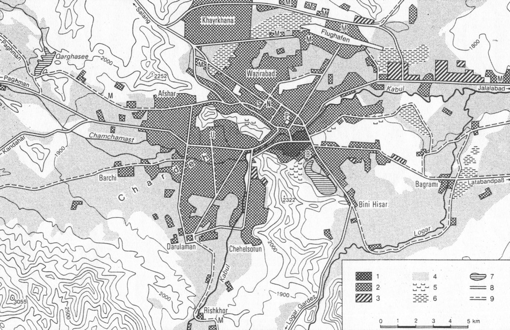
Extensions and transformations of the urban fabric (Figure 7). The competition between Persian-speakers and Pashtuns developed chiefly during the huge topographic expansion of Kabul from the 1930s on, which made it by 1980 a metropolis that totally transcended the traditional city. In this respect Kabul conformed to a model observed to a greater or lesser degree for all cities of the Muslim world during the 20th century, but it did so in very specific ways. The development of a modern town next to the old city happened slowly and was, in its essentials, planned.
The new quarter that gradually developed around the new royal palace north of the river remained very modest until about 1930 (while Amān-Allāh’s Dār-al-Amān was totally marginalized). At the beginning of Nāder Shah’s reign, the old city of Kabul still held nine-tenths of the city’s inhabitants—this at a time when the modern sections of cities all over the Arab and Iranian Muslim world often had become predominant, or at least were almost as populated as the traditional quarters. Construction of the Šahr-e Naw (New City) quarter started in 1935, northwest of the royal quarter on the left bank of the river and along the northern road, and was completed in 1945. The overall plan, as well as the style of the buildings, intentionally broke with the old fabric. The roads intersected in a grid pattern, thus aligning the relatively large house and garden lots (avg. 2,000 m2, min. 1,000 m2) surrounded by walls. The houses were single-storey, of a style more or less resembling the Anglo-Indian bungalow, but they were adapted to a more severe climate in winter and built of different materials: the lack of wood led to using brick, which was generally unbaked to start with, and later more often baked. There were usually four to six rooms, plus a servant’s room in a corner next to the kitchen. Windows were Western-style.
Water was supplied from tanks situated on the roofs, which were always flat, and heating was through European-type fireplaces, of which there was originally only one in each home, and later often several. Each house had an enclosed sun porch/winter garden (gol-ḵāna) with a number of windows on the sunny side. Along the streets, the walls enclosing the lots were normally continuous, with a single entrance per residence. Thus they provided an aspect intermediary between the traditional Muslim cities and that of European towns, while preserving the intimacy of family life in an already modern context. The district was laid out around an extensive public garden that included buildings for collective use (such as a center of worship, a school, a hospital), and a small number of local shops were established at the main crossroads. Embassies of countries that had recently entered into relations with Afghanistan (for example, Japan, Poland, Austria, India, Indonesia) rapidly mingled with the private residences.
This pattern was followed by almost all the later extensions to the city, which multiplied from the 1940s on. These neighborhoods were adapted to the needs of the upper and middle classes, who were joined there by an ever increasing number of foreigners after World War II. (Afghanistan was, in the 1970s, the country with the highest number per capita of foreign ‘experts,’ Westerners and Soviets in approximately equal numbers.) To the north, there was the Šērpur quarter, directly opposite Šahr-e Naw, begun in 1955; then to the northwest, on the Paḡmān road, those of Parwān Mina (1954-59) and Bāḡ-e Bālā Mina (1960); and lastly in the 1960s, again on the northern road, the very large area of Ḵayr-ḵāna. The latter was originally separated from the urban area by an undeveloped space of two to three km. This area already had 30,000 inhabitants in 1976, when a project for an additional 4,000 dwellings was launched (Grötzbach, 1990, p. 38). Development of Kārta Wali, east of the royal palace, began in the 1950s; and in the 1970s, the quarter of very modern and luxurious villas of Wazir Akbar Khan Mina was built east of Šahr-e Naw and north of the palace, on the site of the old airport. Here dwelt the highest classes of Afghan society.
At the same time, there developed outgrowths of this type here and there around the old city as well, limited only by the obstacle of the Kōh-e Āsmāʾi and the Kōh-e Šēr Darwāza promontories to the west, and by the marshy areas to the east, the presence of which required the built-up area simply to be divided into smaller lots. While the new quarters to the north and northwest were mainly occupied by the relatively well-to-do classes, these in the west, southwest, and east were settled by the middle classes. Population density remained very low in Šahr-e Naw (4,000 persons per km2, or 40 per ha) and in the northern quarters (5,000-6,000 per km2, Hahn, 1964-65, I, p. 27), but it was considerably higher here, where the average lot size was 300-600 m2, and houses were considerably smaller. The notion, however, of relatively open, airy neighborhoods that represented a transitional type of habitation between the traditional, closed-in cities and a more modern style did not change. Thus west of the gap between Kōh-e Āsmāʾi and Kōh-e Šēr Darvāza, there developed a series of new neighborhoods. Beginning in 1942, along the road to Qandahār and south of it, was Kārta Čār, of which the first portions, to the east, comprised relatively large lots; later lots were considerably smaller. After 1950, there were Kārta Panj and Jabal-e Mina, to the north of the same road and east of the university (with 120 inhabitants per hectare). Farther west, beyond the university and on either side of the road, were Kārta Deh Buri (beginning in 1948) and Kārta Deh Naw (1950); and to the southeast was Kārta Seh (1958), with larger lots and multi-storied houses corresponding to a higher social level, which connected the urban fabric to Dār-al-Amān (Hahn, 1964-65, I, p. 28). Major marshy areas east of the old city limited the developments in that direction. Nevertheless, the housing project of Kārta Šāh Šahid (with 150 inhabitants per hectare) was built in 1952 between the road to Gardēz and that to Lataband-Sarubi, followed by that of Nur Moḥammad Šāh Mina along the Lataband road, which was mainly occupied by industrial workers, whose population then increased (see below) in this eastern suburb (Hahn, 1972, p. 27).
In this eastern sector there appeared for the first time, northwest of the old town and on the southern bank of the river near the stadium, the first set of multi-storied, collective buildings. These were called the Nāder Šāh Mina, where in 1974 fifty-five large buildings were constructed, with a total of about 2,000 apartments and about 10,000 inhabitants. Fourteen buildings with 536 apartments followed in 1975, somewhat further north. This marked the sudden appearance in Kabul of blocks done in Soviet Central Asian style; they were built partly of prefabricated elements, with aid from the Soviet Union. Mainly intended for lower-level civil servants, they introduced a new collective model that expressed the growing political influence of their powerful northern neighbor and competed with the Western-style detached houses which had so far prevailed (Grötzbach, 1979, p. 28).
These planned extensions formed the major part of the city’s growth from the 1940s to the communist revolution of 1978. They surrounded the old city on all sides—except that Kōh-e Šēr Darvāza in the south and the marshes in the east had not been crossed—with new city quarters having individual names and often still separated by areas not yet subdivided. It was inevitable that spontaneous developments should spring up in the empty spaces. These were often small neighborhood shops by the roadside, put up with haphazard construction. There were, however, especially on the lower slopes of the mountains, and above all on the southern slopes of the Kōh-e Āsmāʾi and the northern slopes of the Kōh-e Šēr Darvāza, zones of a makeshift, rural or semi-rural type of house of uncertain viability and built on properties with dubious title. They did not look like downright shantytowns, which hardly existed at this period in Kabul, but they resembled them in terms of inhabitants and social structure (Bechhoefer, 1977). On the slopes of the Kōh-e Šēr Darvāza, these areas of uncontrolled colonization attracted the surplus population of the old city—its natural demographic increase—who had no more room to expand. On the slopes of the Kōh-e Āsmāʾi there lived, in the 1970s, 43 percent of the immigrant population that came directly from other parts of the province (Hahn, 1972). This population pattern was also found further from the center, in settlements of a village type dispersed in distant suburbs, especially to the southwest, but also northeast and east of the city.
In the settlements on the slopes there spontaneously developed separation by ethnic and, especially, religious group, something that seems to have been exceptional in the planned extensions. In the latter, affiliations were usually not advertised, and people’s backgrounds were diverse. The Kabul melting pot, based on assimilation to the Persian-speaking culture, here operated without opposition, and people were categorized exclusively in terms of levels of income and differences in social class or employment. But in the rudimentary housing areas on the slopes, there often arose distinct community groups. These appeared to be less marked among the Pashtuns, whose Sunnite affiliation did not separate them from the great majority of the population, while the Hazāras were imbued with their popular Shiʿism and tended to group themselves around their centers of pilgrimage (ziārat). They thus formed very homogeneous groups on the slopes of the Kōh-e Āsmāʾi (Deh-e Mazang), especially around their major shrine, the Ziārat-e Saḵi. In general, religious differentiations are much more decisive for the topographic division of ethnic groups than is linguistic diversity.
TRANSFORMATIONS OF THE OLD CITY
Permanence and evolution of commercial functions. Parallel to these new extensions, the old city also developed, but it did so late and slowly. The old urban fabric remained intact for a long time. But, from the end of the 19th century in the Arab countries and from 1930 in Persia under Reza Shah, roadbuilding penetrated many Old City quarters and opened them up to automobile traffic. This did not happen in Kabul until the early 1950s. The first such highway, whose construction took, until the early 1960s, was the great east-west axis of Mayvand Avenue (Jādda-ye Mayvand), which divided the old city into two almost equal parts. Starting on the west from the riverbed, below the Šēr Darvāza heights, it followed the low ground eastward to the cemetery at the edge of the city. Intersecting this road (by means of a traffic circle) was built a north-south axis, Nāder Paštun Avenue. This was much shorter than Mayvand Avenue and led northward up to the river, but to the south it did not reach the limits of the traditional urban fabric. Along these routes there were modern, usually three-storey buildings; the ground floor was occupied by shops which sold manufactured goods, but sometimes (especially at either end of Mayvand Avenue) by artisans’ workshops.
The body of the old bazaar, thus gutted, was transformed behind its old façades, and its organization became profoundly unbalanced (see Hahn, 1964-65, I, pp. 32-35; Velter et al.; Charpentier, in Gazetteer of Afghanistan VI, pp. 330-31). Probably this process of change had already begun as a result of the 1842 destruction of the bazaar and the ensuing restorations, and continued through the first half of the 20th century. The traditional, highly specialized subdivision of commercial and craft activities may already have ceased to be a rigid rule in the late 19th century. In any case, the road building of the 1950s considerably accelerated the dislocation of occupational groups. Thus, the dyers (rangrez), whose main center was destroyed by construction of Mayvand Avenue precisely through it, were disorganized and dispersed across the city (Velter et al., p. 117). It is true that a degree of re-formation of professional groupings developed spontaneously along these major avenues. For instance, merchants selling high-quality fabrics—a luxury trade par excellence—formed a number of new groups at the Mayvand/Nāder Paštun traffic circle (Velteret al., p. 34). Groups of artisans of the same calling also began to appear at either end of Mayvand Avenue. The two main streets of the bazaar were to a great extent spontaneously rebuilt over time in the 1960s-1970s, with houses of more than one floor, which often contained lodgings above the shops. Oriented roughly east-west, these were Šōr Bāzār south of Mayvand Avenue, and Čahār Čata (Four Roofs, a name suggesting the square with four arcades known before the First Anglo-Afghan War), north of it, both east of the traffic circle.
The clustering of shops by occupation more or less ceased, but examples could still be seen in the late 1970s. For instance, in Čahār Čata one could find dealers in vests and turbans (Velter et al., pp. 48-50), teapots (ibid., pp. 79-80), glassware, antique weapons, etc., and in the Šōr Bāzār mainly tailors, who often were Hindus (Hahn, 1964-65, I, p. 32). Most of the shops in the central parts of these two streets sold all sorts of merchandise of Western or Japanese origin, mixed in great disorder with products of native craftsmanship (Velter et al., pp. 40 ff.). Occupational groupings were better preserved on the secondary streets, especially on the periphery of the central nucleus of the bazaar.
Just to the northwest, the market quarter called Bāḡ-e ʿOmumi “Public Park” is clearly a later (late 19th century) extension to the original bazaar. It was organized around a crossroads (with northeast-southwest and northwest- southeast axes), leading to the river. There a well-defined secondary central nucleus of fabric merchants has been maintained, and beyond them groups of salt and soap sellers (Hahn, 1964-65, I, p. 34). Thus new activities also developed around the old commercial center, side by side with the very dense and busy old urban fabric. The roads here, however, were not large enough to meet the needs of the new commercial establishments that started in the 1940s, such as automobile repair shops, which located to the northeast, near the river, from the beginning of the Jalālābād road) and shops of merchants selling aluminum products (Hahn, 1964-65, I, p. 33) also northeast and near the river.
The Kabul bazaar, although its overall features were vividly described in the late 1970s (Velter et al.), was unfortunately not mapped in detail, shop by shop, as other Middle Eastern cities were in that period. It presented a disconcerting contrast between entirely disorganized sections and others where the traditional clustering of shops by occupation was still clearly perceptible. Largely lacking in structure, it nevertheless remained, within its ancient limits, by far the most important local commercial center up to the 1970s. Around 1960, the old city was estimated to contain between 3,000 and 4,000 shops and/or workshops, doing business not only with the city proper, but also with all the villages in the region, and supporting a population of 40,000-50,000 people. This is about the same number as in the 1830s (excluding the entourage of the court), when estimates began to become reliable (Hahn, 1964-65, I, p. 35).
Thus the economic weight of the bazaar, on the whole, hardly changed for a century and a half. In 1960 it still accounted for more than half the total trading establishments and workshops of the city, but during the following decade this proportion began to diminish steadily as a result of the development of new districts. The 1969 census counted only 49 percent in the old city, a little more than 8,000 out of 16,500 total, of which 42 percent were independent shops or workshops and 7 percent were collected in serais having multiple units (Grötzbach, 1979, pp. 40-41). In 1969, the old city had 107,000 inhabitants, a figure probably not much greater than in the 1920s. Its population did change, however, in social composition. All those of a higher social level left it by 1969 to occupy new neighborhoods in the north; they were replaced by new immigrants of rural origin, who were crammed into the large, abandoned residences that were subsequently divided up.
The density of the old city population varied, according to sector, from 500 to over 1,000 inhabitants per hectare (Barrat; cf. above, e.g., 40 per hectare in Šahr-e Naw). Workers who were unqualified or had no permanent work at the bazaar at this time made up about 30 percent of the population, forming a very definite lower social level in comparison with the traditional tradesmen and craftsmen (Grötzbach, 1979, p. 43). To its former function of being a commercial and professional center, the old city had added that of being a residential quarter for the poor.
From the late 1960s, the new neighborhoods acquired the major part of commercial activity, which took on entirely new forms, both in its spatial structures and in the nature of its merchandise. Trading establishments of a modern nature first invaded the broad avenues of the royal quarter, north of the river, and then the southern part of Šahr-e Naw. Their shop windows contrasted sharply with the bazaar booths, and they mainly sold high quality and imported commodities to a clientele of the well-to-do classes and the many foreign residents. Businesses concentrated in these quarters that responded to new needs and offered products not found in the bazaar, for example, ready-made furniture (in the bazaar, people could buy only furniture made to order by artisans). The first ladies’ dressmakers appeared, as well as Western-style hotels and restaurants.
Just north of the river, directly across from the old bazaar, a new commercial area developed, mixed with the administrative and office buildings and airline agencies there and strongly marked by Western influence. From the late 1960s on, this focal area commanded more than a sixth of the city’s commerce (Grötzbach, 1990, p. 202). Despite its modern aspect, the practice of clustering by occupation, even with respect to modern activities, was not totally absent. On both sides of the river, at the periphery of the old bazaar, there were rows of dentist’s offices and pharmacies of European style (Hahn, 1964-65, I, p. 36). To the north, in the new city, groups of carpet merchants and antique shops (catering to the foreigners and tourists, who were starting to appear) and boutiques for imported shoes (ibid., p. 37) began to appear from the 1950s on. But clustering of shops by occupation disappeared from the many commercial sub-centers which developed at various points in the northern quarters (in north Šahr-e Naw and in Šērpur) and then in the west, especially around the university and on the Qandahār road. (The latter area, however, did contain groups of automobile repair shops, as well as the inter-city bus departure points). Finally, as the city spread, numerous small food and neighborhood shops sprang up in the new areas.
INDUSTRIAL DEVELOPMENT
Modern Kabul witnessed not only the growth of new kinds of commerce, but also the appearance of modern industry, of which it became a significant center. On the whole, Kabul became the most important center of diversified industry in Afghanistan, despite the constraints connected with the absence of sufficient energy sources and raw materials, especially wood, which could be brought only from the distant forests of the southeast. From the beginning, industry was vigorously fostered by the state.
The origin of modern industry in Kabul lies in the manufacture of military equipment (rifles, cannons, cartridges, gunpowder) introduced by Amir ʿAbd-al-Raḥmān Khan from the early years of his reign and organized with the aid of foreign experts (Gregorian, p. 143). Military production already amounted to 175 rifles per week in the 1880s, and 3,000 to 20,000 cartridges a day, according to need. Manufacture of other army goods quickly followed, with a tannery to supply leather for boots and harness, a textile mill for woolen uniforms, and also makers of musical instruments for brass bands. This development was continued under Amir Ḥabib-Allāh (r. 1901-19); in 1901-04, Kabul was estimated to have about 1,500 employees working for the government, and in 1919, about 5,000 (Gregorian, pp. 190-91). This form of state industry at least provided the greatest continuity and stability. Private enterprises first began to be formed in the 1930s, but they suffered from instability and experienced numerous failures. Until 1960, the only operative production processes carried on without interruption were run by state enterprises. From 1960 on, small, privately owned factories—mainly food-processing plants—began to multiply and enjoyed some success.
The industry of Kabul is of an urban, highly diversified kind, producing food (industrial milling, oil pressing, etc.), textiles, building materials, furniture and wooden objects, glassware, and other commodities, with supporting service businesses such as repair workshops for small metal products. The location of industrial works in the city was quite precise from the beginning. There were some to the west of the old city, where the river flowed between the flanking ridges, and traces of these remain, but the space there was too confined, and development was soon obstructed. However, there was no lack of space in the Pol-e Čarḵi quarter east of the royal quarter, near the barracks and along the roads running east out of the city. The main industrial works were built here in the 1950-80s, first along the Jalālābād (Tang-e Ḡāru) road (this is the most important and most diverse grouping), then the Lataband road (notably the big state cotton industry works). A third site emerged southwest of Kōh-e Šēr Darvāza as a site for wood and textile industries (producing ready-made garments). The total number of workers in modern industries has never been precisely counted. On the eve of the communist revolution of 1978, their number was estimated to be about 20,000, of whom perhaps about two-thirds or three-quarters were employed by the state.
INFRASTURUCTURE AND PROBLEMS OF URBAN PLANNING
Difficulties such as the scarcity of energy and natural resources have long hampered the city’s development plans. The great majority of Afghanistan’s high-level facilities were always concentrated in Kabul, and, as the capital city, it presented, especially in terms of education and sanitation, a vastly more favorable situation than that of the rest of the country. But the basic infrastructure by no means kept step with the city’s development (Hahn, 1964-65, I, pp. 61-68; Grötzbach, 1979, pp. 49-52; idem,1990, pp. 203-4).
Electricity was introduced in Kabul in 1893 (by means of a diesel generator) and, to begin with, was exclusively reserved for the amir’s court and some state services. It was long supplied only by hydroelectric installations. The first one was built in 1917 at Jabāl al-Sarāj, on the Sālang river north of the Kabul river basin, and remained the only one until just after World War II. At that time, a series of developments was carried out on the Kabul river below the city, at Sorōbay (1957) and Māhipar and Naḡlu (1966-67). Total power amounted to 180,000 kilowatts, but soon proved to be insufficient, especially due to transmission line losses in the city itself. It proved necessary to resort to two oil-powered generators of 45,000 kilowatts each, which went online in 1978 and 1984 respectively. These could not keep up with the growing rate of consumption, and there were frequent breakdowns and power reductions. In 1980, there were officially 70,000 consumers of electricity in the city, without counting the very numerous illegal connections. An estimated two-thirds of the homes in the city were connected then, but the proportion certainly diminished afterwards.
Things were much more critical with regard to the supply of drinking water, despite the fact that the city’s topographical situation was on the whole favorable in terms of water resources. It was close to mountainous regions where there was no lack of running water and situated in a basin with its underground water table well provided. Traditionally, the old city used the water of the Kabul river and its channels and also wells. In addition, some villages of the northern suburbs used underground water channels (kārēz), which were still in use until recently in Šērpur. The first modern general supply network, proceeding from the mountains west of the basin (Paḡmān), was started in 1923, and followed up in 1957 for the Kārta Seh area by a system fed by deep wells, which were very inadequate. In 1968, only 9 percent of the houses were connected with the public system, 58 percent took their water from wells, and the rest from the river or from the channels proceeding from it.
In the 1970s, two additional networks were added, financed by German funds. They were the Afšār project for the west, and the Lōgar project for the east of the city, both proceeding from deep wells reaching underground water, aimed at supplying drinking water for 400,000 people. It is unknown to what extent these objectives were met. In 1977, the number of inhabitants in Kabul having access to healthy water did not exceed 300,000 to 350,000 (Kabul Times, 25 July 1977). In 1987, a project was planned to build, with aid from the Soviet Union, a dam in the Lōgar valley, 12 km south of the city, but there was never the slightest sign of its being carried out. The sanitary conditions connected with this situation remained deplorable. Dysentery was frequent, and recourse to boiled or chlorinated water was essential.
A third major problem for the satisfactory functioning of a metropolis—one less serious than the matter of electricity and water but increasingly felt in daily life in the 1970s—was the question oftraffic. There were in 1977 only 30,000 registered motor vehicles, that is, one for every 25 to 30 persons. Of these, 15,000 were private cars (3,000 belonged to foreigners), 7,000 to 8,000 trucks, somewhat more than 4,000 taxis, and about 3,000 public buses (the only public transport, which was entirely inadequate). While these were relatively modest figures, traffic jams started to be frequent in the new quarters near the old city. The need for a rapid highway between the center and the newest northern quarters (Ḵayr-ḵāna) was being painfully felt. Light-rail projects were envisaged but never begun.
The situation was incompatible with the normal functioning of a city approaching a million inhabitants, and the need for a development plan was already evident in the 1960s. In 1966, the first master planfor urban development was established with Soviet aid and inspiration. This was modified in 1971 and again in 1979. This final version, which projected a million and a half inhabitants by the mid-1990s, officially regulated the city’s evolution until 2003 (Grötzbach, 1979, pp. 52-56; idem, 1990, pp. 204-5). The plan marked a radical change, a complete break with the entire previous evolution of the city and with the earlier concept of how urban life should be organized.
The plan set out from the principle that the way followed until then for developing new city quarters, that is, building a large number of family houses on relatively large plots, would lead to a dead-end (which may be accurate). The new project was to remodel the city’s appearance entirely. The old city would continue to be the main commercial center, and the old royal quarter to the north, with the southern part of Šahr-e Naw, would become a mixed area of administration and business. But both would have to be razed (with the exception of some historical buildings and monuments) and rebuilt as blocks with up to fourteen floors. As for the residential quarters, the aim was to condense them considerably so as to reach densities of 220 to 250 inhabitants per square hectare (compared with the existing 40-140 per square hectare; see above). This could be accomplished only by pulling down 70 percent of the existing homes. Of the replacement buildings, 10-15 percent would be 10-storey or higher, 65 -70 percent 5-6 storey, and only 20-25 percent 3-storey or less. These housing zones were to be divided into four districts, each having a complete sub-center (administrative, economic, cultural, even concert halls) and numerous smaller centers according to scale (Grötzbach, 1979, pp. 52-56; idem, 1990, pp. 204-5) Apart from the ideological and visionary character of this idea of uniformization and its obvious lack of any adaptability to the population’s cultural and family traditions, the plan contained not a single word about the immense financial resources needed, such as for expropriation indemnities. The project was completely surrealistic in the context of a very poor country almost lacking in any kind of credit structure, as Afghanistan still was at the time. It meant, purely and simply, a veritable social as well as urban revolution, leading to the introduction into Afghanistan of a collective type of city and lifestyle such as had been imposed on Central Asia by Soviet power. Devised when the republic was at its zenith and within its main control center, the plan was a prelude to the impending communist revolution (Figure 8).
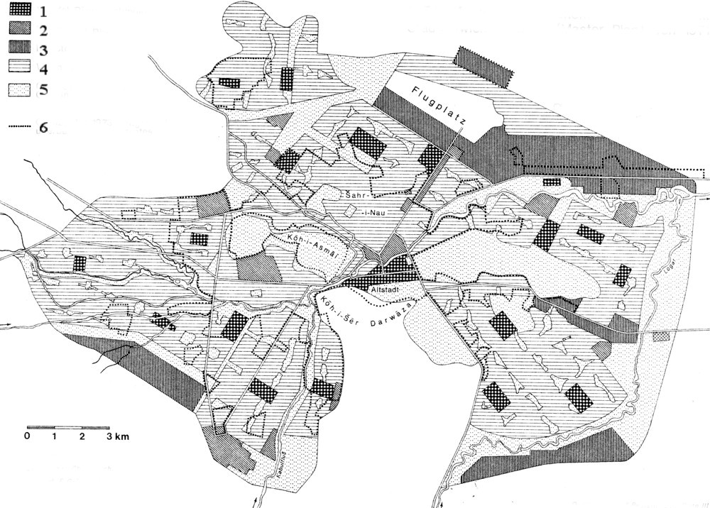
CONSEQUENCES OF THE PERIOD OF TROUBLES AND WARS (SINCE 1980)
The views of the master plan have been radically challenged by the course of events in Afghanistan since the 1980s. For this period, data for gauging the evolution of the city is sadly lacking. No Western scholar has been able to work seriously on this matter, and precise observations, which were already very difficult under the communist régime, became impossible under the Taliban (Ṭālebān). Fights between factions, after the fall of the communist régime (marked by the Mujahidin entry into Kabul on 15 April 1992) provoked major destruction, particularly in the fiercely disputed central quarters (especially Mayvand Avenue); but it is impossible to estimate even roughly the proportion of the urban fabric that has been entirely or partially ravaged. The master plan described above remained unimplemented during the communist period. But construction continued on the blocks of collective residential buildings developed especially towards the northeast, on either side of the road to the airport. These were described by the Soviet term mikroraĭon, abbreviated as Mikroyān in Kabuli Persian (Grötzbach, 1990, p. 198). Similar blocks were built to the south between Kōh-e Šēr Darvāza and the river. The rate of building collective prefabricated housing rose to some 800 apartments a year (Kabul New Times, 25 August 1987). At the same time, however, an attempt had to be made to account for the financial requirements of this effort, which were estimated at about 200 billion Afghanis (compared to the 30 billion Afghanis for the value of the existing built-up property). For the twenty-five-year duration of the master plan, the greater part of Afghanistan’s budget was devoted to the mere urban transformation of the capital.
The communist government must have recognized the anomaly; from 1982 on, it tried to launch much less expensive projects, including traditional buildings of a much more rudimentary kind than the large, prefabricated collective blocks. For instance, the development Nawābād-e Pol-e Čarḵi east of the city was intended to accommodate 80,000 to 100,000 persons (Kabul New Times, 4 February 1982). The density anticipated was to reach 230 inhabitants per hectare, but at a much lower cost than that of the plan and according to a very different social model, which was to relegate the lower social classes to the city’s outskirts (Grötzbach, 1990, p. 205). Thus 13,300 plots of land were distributed from 1978 to 1984 (Kabul New Times, 9 January 1985). These projects were, in any case, quite incapable of accommodating the surplus of the new population. In the same time period, the influx of refugees led to a considerable illegal construction (Grötzbach, 1990, p. 205).
One indisputable conclusion, despite the absence of precise data, is that the growth in Kabul’s population greatly accelerated during the period of Soviet occupation (1979-89), due to the great influx of refugees leaving the insecure zones of the countryside. A census taken in 1986, the results of which were published in theKabul New Times of 8 February 1987 (Grötzbach, 1990, p. 199), provided the figure of 1,286,000 inhabitants. The estimates for the early 21st century are more than 2 million people. Both are plausible numbers, although unsupported by data. Within this population, it is impossible to describe what important transformations in its ethnic makeup may have occurred and how people were divided into different residential groups. It is at least probable that the part played by the Pashtuns in the area diminished. During the war of resistance against the Soviet occupation, Pashtuns emigrated massively to Pakistan, whose border was not far from their home settlements, while the natives of the northern Tajik country and the Hazāras of the center tended to seek refuge in the big city. It appears certain that the predominance of the Persian-speaking element in Kabul became more marked. At the same time, community groupings became more frequent within the city itself, especially west of the areas of temporary dwellings, and above all among the Hazāras. The conflicts between different factions after the evacuation of the Soviet troops took on a very marked inter-ethnic character in Kabul.
Economic life in the city was in great turmoil. The suppression of most foreign-made imported objects over a long period, the at least partial return to an “subsistence economy” in a context of general impoverishment, led to a near extinction of certain occupations in the bazaar, while others flourished. For example, from 1986 on, jewelers and goldsmiths, having lost their creditworthy clients, were replaced by sellers of oil lamps, whose trade prospered because of the increasingly frequent power cuts. Sellers of the Nuristāni-type (“chitrali”) caps, which had become a symbol of resistance, had a brisk trade. But all occupational activities relying on charcoal were difficult to carry out, due to its growing scarcity in the city. North of the river, in the transitional area leading to the modern commercial streets of Šahr-e Naw, there developed a vast illegal market at the site of the tinsmiths’ bazaar. Here there were all kinds of commodities pilfered by Soviet soldiers and officers, such as motorcycle tires, water pumps for jeeps, and cable sheathing. This so-called Bāzār-e Brejnev (Brezhnev’s market) also became a center for black-market gasoline when the latter became difficult to obtain.
Damage to the city included, in the early 1980s, the razing of a large part of the Šōr Bāzār, as well as an entire section of the musicians’ street and part of the blacksmiths’ quarter, in order to create an access lane 30 m wide for tanks (Delloye and Velter). This was in response to an attack carried out as early as 1979 against the police station of the Shiʿite district of Čandaval, Under the Taliban (1992-2001), life in the city was much affected by the prohibition of all cultural activities (music, films, painting, etc.), and these completely disappeared from view.
An even more serious problem was that, in the twenty-five years from 1980 on, Kabul’s ascendancy over the rest of the country was considerably reduced. The political capital lost a major part of its functions of dominance, which it had patiently acquired in the course of the preceding half-century, over other centers of decision-making. In the early 21st century, Herat and Mazār-e Šarif in particular, and Qandahār, form largely autonomous centers of economic activity. They, in fact, organize foreign relations and smuggling across the increasingly theoretical frontiers. The reconstruction of an effective central power and the control of its environs will be long and difficult to bring about, considering its currently isolated and marginalized condition. Given a vast territory and a truly hierarchical urban network, Kabul indeed appears like a capital still to be built.
Bibliography
Ludwig W. Adamec, ed., Historical and Political Gazetteer of Afghanistan VI: Kabul and Southeastern Afghanistan, Graz, 1985.
Jamal-ud-Din Ahmad and Muhammad Abdul Aziz, Afghanistan, A Brief Survey, London, 1936.
Muhammed Ali, Guide to Afghanistan, Kabul, 1938.
Ghulam Jailani Arez, “Urban Structure of Kabul,” Geographical Review of Afghanistan 3, 1973, pp. 1-19.
James Atkinson, Sketches in Affghanistan, London, 1842; repr., The London Illustrated News, 73, no. 2054, 9 Nov. 1878, [p. 433].
Ẓahir-al-Din Moḥammad Bābor,Bābor-nāma, facs. ed., Annette S. Beveridge, London, 1971; tr. Annette S. Beveridge asBābur-Nāma (Memoirs of Bābor), 2 vols.London, 1922; tr. Wheeler M. Thackston as Bâburnâma: Chaghatay Turkish Text with Abdul-Rahim Khankhanan’s Persian Translation, 3 vols., Cambridge, Mass., 1993.
Daniel Balland, “L’immigration des ethnies turques à Kabul,” in Erwin Grötzbach, ed., Aktuelle Probleme der Regionalentwicklung und Stadtgeographie Afghanistans, Afghanistan Studies 14, Meisenheim am Glan, 1976, pp. 210-24.
Jacques Barrat, “Kabul, capitale de l’Afghanistan,” Ph.D. diss., Faculté des Lettres et Sciences Humaines, University of Paris, Sorbonne, 1970.
William B. Bechhoefer, “Serai Lahori: Traditional Housing in the Old City of Kabul,” Afghanistan Journal 3, 1976, pp. 3-15.
Idem, “The Role of Squatter Housing in the Urbanization of Kabul,” Afghanistan Journal 4, 1977, pp. 3-8.
André Berthelot, L’Asie ancienne centrale et sud-orientale d’après Ptolémée, Paris, 1930.
Clifford E. Bosworth, The Ghaznavids: Their Empire in Afghanistan and Eastern Iran 994-1040, 2nd ed., Beirut, 1973.
Alexander Burnes, Travels into Bokhara: Being the Account of A Journey from India to Cabool, Tartary and Persia . . . , 3 vols., London, 1834.
Idem, Cabool: Being A Personal Narrative of A Journey to, and Residence in That City, in the Years 1836, 7, and 8 . . . ,London, 1842.
Emmanuel Delloye and André Velter, “Kaboul: les bazars ont perdu leur âme, un entretien avec Mohammad Ali Raonacq,” Le Monde Aujourd’hui, nos. 23-24, March, 1986, p. VII. Louis Dupree, Afghanistan, Princeton, 1973.
Idem, “Settlement and Migration Patterns in Afghanistan: A Tentative Statement,” Modern Asian Studies 9, 1975, pp. 397-413.
Mountstuart Elphinstone, An Account of the Kindom of Caubul and Its Dependencies in Persia, Tartary and India, London, 1815.
Vincent Eyre, The Military Operations at Cabul, Which Ended in the Retreat and Destruction of the Britsh Army, January 1842 . . . ,London, 1843.
Fa-Hsien,The Travels of Fa-Hsien (399-414 A.D.), or Record of the Buddhistic Kingdoms, re-tr. by Herbert Allen Giles, London, 1923.
George Forster, A Journey from Bengal to England through the Northern Part of India, Kashmir, Afghanistan and Persia . . . , 2 vols., London, 1808.
Alfred Foucher, La vieille route de l’Inde, de Bactres à Taxila, 2 vols., Paris, 1942-47.
Maurice Fouchet, Notes sur l’Afghanistan; oeuvre posthume, Paris, 1931.
William Kerr Fraser-Tytler, Afghanistan: A Study of Political Developments in Central and Southern Asia, 2nd ed., London, 1953.
Vartan Gregorian, The Emergence of Modern Afghanistan: Politics of Reform and Modernization 1880-1946, Stanford, 1969.
Erwin Grötzbach, Städte und Bazare in Afghanistan: Eine stadtgeographische Untersuchung, Wiesbaden, 1979.
Idem, Afghanistan: Ein geographische Landeskunde, Darmstadt, 1990.
Helmut Hahn, Die Stadt Kabul (Afghanistan) und ihr Umland I: Gestaltwandel einer orientalischen Stadt</em>; II: Socialstruktur und wirtschaftliche Lage der Agrarbevolkerung im Stadtumland, Bonner geographische Abhandlung 34-35, Bonn, 1964-65.
Idem, “Wachstumsabläufe in einer orientalischen Stadt, am Beispiel von Kabul (Afghanistan),” Erdkunde 26, 1972, pp. 16-32.
Mohammad Jamil Hanifi, “Preindustrial Kabul: Its Structure and Function in Transformational Process in Afghanistan,” in Amos Rapport, ed., The Mutual Interaction of People and Their Built Environment: A Cross-cultural Perspective, The Hague, 1976, pp. 441-51.
Howard Hensman, The Afghan War of 1879-80: A Complete Narrative of the Capture of Cabul, the Siege of Sherpur, the Battle of Ahmed Khel . . . , London, 1881.
Ḥodud al-ʿālam, ed. Manučehr Sotuda, Tehran, 1961; facs. ed. and tr. Vladimir Minorsky asḤudūd al-ʿĀlam ‘The Regions of the World’: A Persian Geography 372 A.H.-982 A.D., London, 1937.
Johannes Humlum, La géographie de l’Afghanistan: étude d’un pays aride, Copenhagen, 1959.
Charles M. MacGregor, Central Asia, pt. 2: A Contribution Toward the Better Knowledge of the Topography, Ethnology, Resources, and History of Afghanistan,Calcutta, 1871; repr., Petersfield, 1995.
George Fletcher MacMunn, Afghanistan from Darius to Amanullah, London, 1929.
Moḥammad-Kāẓem Marvi, ʿĀlamārā-ye nāderi, ed. Moḥammad-Amin Riāḥi, 3 vols., Tehran, 1985.
Charles Masson, Narrative of Various Journeys in Baluchistan, Afghanistan and the Panjab from 1826 to 1838, 3 vols., London, 1842; repr., Graz, 1975.
A. Miquel, La géographie humaine du monde musulman jusqu’au milieu du lle siècle, 4 vols., Paris, 1967-88.
Mohan Lal, Travels in the Punjab, Afghanistan and Turkestan to Balkh, Bokhara, and Herat, London, 1846; repr., Patiala, 1971.
Oscar von Niedermayer, Afghanistan, Leipzig, 1924.
Maurice Pernot, L’inquiétude de l’Orient II:En Asie Musulmane, Paris, 1927.
Xavier de Planhol, “Kabul et le réseau urbain de l’Afghanistan, d’après Jacques Barrat,” Revue Géographique de l’Est 13, 1973, pp. 189-97.
Idem, “Éléments autochtones et éléments turco-mongols dans la géographie urbaine de l’Iran et de l’Afghanistan,” Bulletin de l’Association de Géographes Français, no. 417-18, 1974, pp. 149-60.
Idem, Les Nations du Prophéte: Manuel Géographique de Politique Musulmane, Paris, 1993.
Proctor and Redfern International Limited,Water Supply, Sewerage, Drainage and Solid Waste Systems for Greater Kabul: Joint Interim Master Plan II, Toronto and Kabul, 1972 (mimeograph).
Carl Rathjens, “Kabul, die Hauptstadt Afghanistans,” Leben und Umwelt 13, 1957, pp. 73-82.
Idem, “Kabul: zur Geographie einer orientalischen Stadt und ihres Umlandes,” Die Erde 96, 1966, pp. 209-12.
Rafi Samizay, “Urban Growth and Residential Prototypes in Kabul, Afghanistan,” M.A. thesis, Massachusetts Institute of Technology, Cambridge, Mass., 1974.
Sydney H. Shadbolt, The Afghan Campaigns of 1878-1880, 2 vols., London, 1882.
J. Sibinga-Mulder, “Kabul, Hoofstadt van het Koninkrijk Afghanistans,” Tijdschrift van het Koninklijk Nederlandsch Aardrijkskundig Genootschap 74, 1957, pp. 160-68.
O. Stein, “Ortospana,” in RE XVIII/2, cols. 1507-8.
Abdülvehhâb Tarzi, “Kabil,” İslâm Ansiklopedisi VI, Istanbul, 1953, pp. 16-22.
André Velter, Emmanuel Delloye, and Marie-José Lamothe, Les Bazars de Kaboul, Paris, 1979.
Godfrey T. Vigne, A Personal Narrative of A Visit to Ghuzni, Kabul, and Afghanistan, and of a Residence at the Court of Dost Mohamed, London, 1843; repr. Lahore, 1982.
Roland Wild, Amanullah, Ex-King of Afghanistan, London, 1843; repr. Quetta, 1978.
Charles Edward Yate, Northern Afghanistan, London, 1888.