

KABUL
v. Monuments of Kabul City
The modern city of Kabul has expanded to such an extent in the last three decades that it now spills out from the Kabul valley. This article focuses on the major monuments in and around the Old City of Kabul and the most significant Dorrāni dynastic monuments and mausolea.
BĀLĀ HEṢĀR AND KABUL CITY WALLS
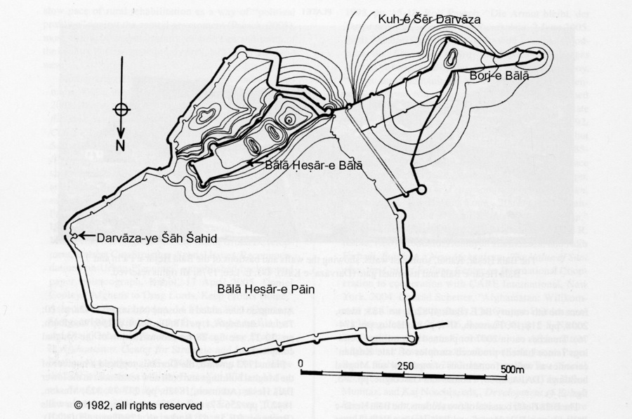
The Bālā Ḥeṣār fortress is the heart of the ancient city of Kabul (for ground plan see Figure 1 and Ball, 1982, II, plan 35-1; Sturt, 1839; Woodburn, pp. 8-9, 33, figs. 5 and 27). It is located on a ridge on the northeastern slopes of the Šēr Darvāza mountain. Discoveries of Achaemenid and Indo-Greek coins suggest a settlement existed here from the 6th century BCE (Ball, 1982, I, no. 483; idem, 2008, pp. 218-19; Fussman, II/1, p. 83; Hulin, pp. 174-76). Trenches cut in 2007 for planned new military buildings (since halted) produced samples of ‘late Kushan’ ceramics as well as foundations of medieval and Mughal buildings (DAFA, 2008; Thomas and Gascoigne, pp. 2-5, figs. 2, 4).
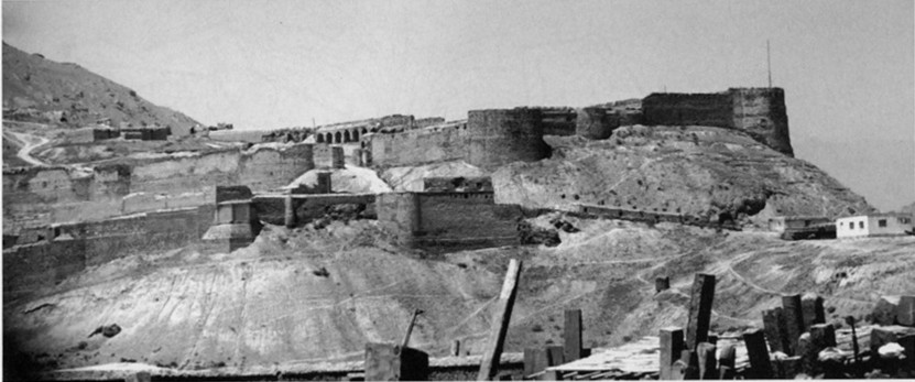
The Bālā Ḥesār consists of two sections, the Bālā Ḥesār-e Pāʾin “Lower Bālā Ḥesār” and Bālā Ḥesār-e Bālā “Upper Bālā Ḥesār” (see PLATE I). The lower Bālā Ḥesār covers a low, terraced mound on the north, west, and east faces of the citadel and encompasses approximately 42 hectares (cf. Hough, p. 285). The high, thick stone and packed mud walls that are still visible date mainly from the mid-18th to late 19th centuries (Atkinson, 1842b, pp. 277-79; Bucherer, RE 60; Masson, 1842, II, p. 250; Woodburn, pp. 10-13, figs. 6, 7, 9, 12). The slope of the hill below the walls has been enhanced to form a glacis. On the south side are the remnants of an early 19th-century faussebraye (a second, lower rampart; Hough, p. 287; Masson, 1842, II, p. 250; Woodburn, pp. 7, 15). The outer defenses were once surrounded by a wet ditch (now dry), while the south side of the citadel was protected by the Ḥašmat Khan marsh (Bucherer, RE 56; Burke, no. 173/Photo 430/3[5].; Sturt, 1839).
Both outer and inner walls are punctuated by D-shaped bastions (Hough, facing page 67; Masson, 1842, II, p. 257; idem, Sketches, no. 35; Sturt, 1839). The interior of the walls included vaulted casements with angled fire loops. The bastions and walls are surmounted by plastered mud and brick parapets with merlons and angled, hooded fire points (Atkinson, 1842a, pl. 20; Burke, no, 179/Photo 430/3[22]; Masson, 1842, II, p. 250; Woodburn, pp. 11-12 and figs. 9, 11). The Mughals substantially strengthened the outer line of walls and extended the area of the lower fort northwards. Jahāngīr constructed new palaces, audience halls, and a garden (čahārbāḡ). Aurangzeb later added a mosque (Atkinson, 1842a, pl. 20; Tūzuk-i-Jahāngīrī, I, p. 118; Burnes, I, p. 156; Woodburn, pp. 20-21, see fig. 28 for reconstruction of the Mughal complex).
From 1773 onward, the Dorrānis replaced a number of the Mughal buildings and built new residences in the lower Bālā Ḥesār (Atkinson, 1842b, pp. 277-79, 323; Masson, 1842, I, pp. 256-57) and on the eastern and southern walls (Bucherer, RE 58, 62; Burke, no. 179/Photo 430/3[22]). In the 1830s some 1,000 shops were located in the eastern and western quarter of the Bālā Ḥeṣār-e Pāʾīn. There were also barracks, stables, a parade ground, and administrative buildings (Atkinson, 1842a, plate 20; Bucherer, RE 71; Hough, p. 285; Masson, 1842, II, p. 255; Schinasi, p. 43). An Armenian quarter (maḥāla) and church was located inside the Šāh Šahid (eastern) gate (Allen, pp. 311-12; Burnes, I, p. 150; Lee, 2002, pp. 158-59; Masson, 1842, II, p. 255). In late 1879, General Roberts ordered the leveling of the bazaars, the neglected Mughal and Dorrāni structures, and the Armenian church (Bucherer, RE 54; Gray, p. 209; Lee, 2002, pp. 160-61; Moncrieff, p. 89; Schinasi, p. 43; Woodburn, pp 32-33, fig. 45).
Only fragments of Mughal and 18th-19th century structures survive. They include: elements of the Darvāza-e Kāši and Darvāza-e Šāh Šahid barbicans (Bucherer, RE 59-60, 67; Burke, no. 179/Photo 430/3[22]; Woodburn, fig. 16), sections of the parapet, and fragmentary tile work (Woodburn, pp. 11-12, 16 and figs. 10-12, 17-19). Notable 19th- century structures such as Šāh Šojāʿ’s Audience Hall (Atkinson, 1842a, plate 22; Bucherer, RE 66; Burke, no. 285/Photo 43/3[29]; MacGregor, p. 107; Rattray, pl. 3; Schinasi, p. 43) and the Residency where Maj. Cavagnari and his escort of Guides were massacred in 1879 (Bucherer, RE 63-65; Woodburn, pp. 27, 30, see fig. 41 for reconstruction) have not survived.
The Bālā Ḥesār-e Bālā, or upper fortress, lies on an elevated knoll in the southeast corner of the citadel. It is enclosed by its own wall with three-quarter circle bastions. The ruined main gate, the Darvāza-e Kāši is located in the angle of the south and east walls (Bucherer, RE 55; Burke, nos. 214-15, 218/Photo 430/3[7-8, 4]; Masson, 1842, I, p. 254; Sturt, 1839). Timur Šāh Dorrāni and his successors turned the upper Bālā Ḥesār into a state prison (Atkinson, 1842b, p. 278; Forster, II, p. 83; Masson, 1842, II, p. 253). One of the two wells, near the Darvāza-e Kāši, became the notorious Siyā Čāh dungeon (Burnes, I, p. 156; Lee, 1996, p. 555; Martin, pp. 149-50; Masson, 1842, II, p. 254). The fort was finally abandoned as a fortified royal residence in the 1890s (Schinasi, p. 72).
Above the main fortress on a knoll of the Šēr Darvāza are the remains of a brick and mud plaster tower known as the Borj-e Laḡlaḡu, Borj-e Hulāgu, or Bālā Borj (Burke, no. 212/Photo 430/3[85]; Masson, 1842, II, pp. 250-51; Woodburn, p. 13), which overlays a stupa, part of the Ḵʷāja Ṣafā complex (Fussman, II/1, pp. 83-84). In the early 19th century, the keep was linked to the Bālā Ḥesār by a line of parallel mud walls (Bucherer, RE 56; Burke, no. 229/Photo 430/3[9]; Sturt, 1839). The tower’s function was to strengthen defenses on the southwest from artillery and musket fire laid down from the Šēr Darvāza heights (Masson, 1842, II, pp. 250-51).
The walls of the old city run for some 5 km to the west of the fortress from the Borj-e Hulāgu (AKTC, no. 14, 2008, p. 2). One line runs up the ridgeline of the Šēr Darvāza to the Taḵt-e Šāh peak. A second line descends into the Deh Mazang gorge, where it crosses the Kabul river, and ascends the Kuh-e Asmāī and down its north face, terminating west of Deh Afḡānān (AKTC, no. 14, 2008, p. 2; Caspari, pp. 33-36; Dupree, pp. 99-100). The walls were once punctuated by six gateways, none of which have survived. Stone and mud plaster fortifications along their length give a Hephthalite (6th cent. CE) date in some sections (Ball, 1982, I, no. 483; idem, 2008, p. 218). The walls must be considered multi-period, since they have been repaired and rebuilt on many occasions.
BUDDHIST AND HINDU-SHAHI MONUMENTS
Kabul’s main Buddhist complexes are located in southeastern Kabul in an arc along the eastern face of the Šēr Darvāza mountain and the Taḵt-e Šāh (for site distribution, see Ball, 1982, II, Map 110; Fussman, II/1, p. 80, idem, II/2, pl. 3). The “Ḥašmāt Ḵān” complex (Ball, 1982, I, no. 418), lies to the south of the marsh of the same name and consists of a series of monastic complexes (ca. 1st-5th cents. CE) mostly overbuilt by modern shrines, graves, and houses. The Panja-ye Šāh-e Mardān group is located on and around the ridge to the west of the shrine of the same name and stretches up the Taḵt-e Šāh as far as Tepe Naranj (Ball, 1982, I, no. 1905; Fussman, II/1, pp. 85-93, idem, II/2, pls. 11, 82; Ḵalil, pp. 39-40). Masson’s excavations uncovered arched recesses, clay statues, wall paintings, and manuscript fragments (Masson, 1842, II, pp. 235-36; idem, III, pp. 93-96; idem, Sketches, no. 4). Recent excavations, from 2004, have uncovered a substantial monastic complex which includes cylindrical, diaper masonry stupas and clay statues (Fussman, II/1, pp. 86-90; idem, II/2, pls. 83-87).
The Ḵʷāja Ṣafā monastic complex is situated some 800 m northwest of the Bālā Ḥesār (Ball, 2008, pp. 218-19; Fussman, II/1, pp. 81-83; Masson, 1842, II, p. 252; idem, III, pp. 92-98), to the east of the shrine of Ḵʷāja Ṣafā. Excavations by the Afghan Institute of Archaeology (commenced 2004) have shown the site to be extensive with at least one diaper masonry monastery and a large stupa (3.9 m × 3.10 m). Preliminary dating indicates two phases of construction (4th-5th cents. CE; Fussman, II/1, p. 82). The unexcavated site of Tepe Ḵazāna, at the extreme northern tip of the Šēr Darvāza, today lies under a hospital. The site’s dating (5th-7th cent. CE) is based on the chance discovery of some fifty figurines (Ball, 1982, I, no.1168; N. Dupree, L. Dupree, and Motamedi, pp.103-5, fig. 44; Fussman, II/1, pp. 80-81; Tissot, pp. 347-51).
A further two diaper masonry stupas and monasteries complexes are located on the south face of Tepe Marajān (‘Maranjān [sic] 1 and 2’) below the tomb of King Nādir Šāh (Ball, 1982, I, no.1173 and II, plan 49; Fussman and Le Berre, pp. 95-99). ‘Maranjān 2,’ the earlier site (Kushan, 1st-3rd cents. CE), is situated at the base of the slope and consists of a monastery and seven stupas. A reliquary was found inside the main stupa (Fussman, II/1, pp. 99-103; idem, II/2, pls. 76 [ground plan] and 77-81). The monastery at ‘Maranjān 1’ (3rd-4th and 5th-6th cents. CE) to the east was ornamented with wall frescoes. Two hordes of Kushano-Sasanid and Sasanid coins were recovered from the site (Carl and Hakin, pp. 7-12; Dollot, pp. 284-5; Fussman, II/1, pp. 95-99 and II/2, pls. 74-75; Fussman and Le Berre, pp. 95-99).
TIMURID AND MUGHAL
No pre-Timurid Islamic monuments survive in Kabul city. The construction of the Bālā Jui canal, is attributed to the reign of Uluḡ Beg (reigned 1411-1449 CE; Bābor-nāma, tr., pp. 200-201). It brought water from the Logar river to the Bāḡ-e Bābor and terminates in the upper Bālā Heṣār (Masson, 1842, II, pp. 284-85; Woodburn, p. 25). Scattered monumental fragments of a Timurid structure (4 m high, 11 m × 6 m base), probably a recreational pavilion, were recorded on the peak of Taḵt-e Šāh (Ball, 2008, p. 220; Bābor-nāma, tr., p. 200; Masson, 1842, II, pp. 234-35, 284-85; idem, Sketches, nos. 48-50). The baked brick, single domed tombs of Šēr-e Surḵ and the Ziārat-e Seh Uluḡ in the Ḥašmat Khan area are also attributed (stylistically) to the late Timurid period (Ball, 1982, I, no. 418; Burke, nos. 180, 181/Photo 430/3 [21, 20]; Dupree, p. 113; Ḵalil, pp. 30-31, 47-49). Excavations within the grave enclosure of the Bāḡ-e Bābor have uncovered foundations of a Timurid structure, possibly a tomb (Franke-Vogt, Barti, and Urban, p. 545 and fig. 7).
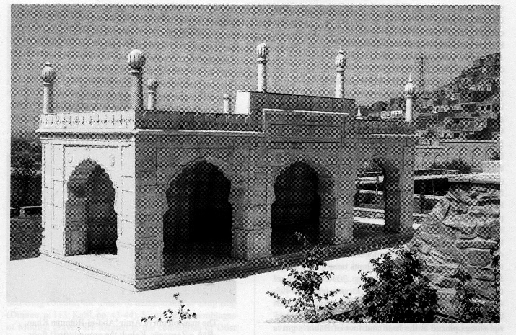
The most significant and best preserved Mughal monument of Kabul city is the Bāḡ-e Bābor, “Bābor’s Garden,” on the western slope of the Šēr Darvāza (for ground plans, see: Franke-Vogt, Barti, and Urban, p. 540; Leslie, pp. 5, 16-19; Parpagliolo, plans 1, 3-6). The present garden extends to some 11 hectares and was laid out during Bābor’s reign as a čahārbāḡ on the site of a Timurid tomb-garden (Bābor-nāma, tr., appendix V, p. lxxx; Franke-Vogt, Barti, and Urban, p. 545; Masson, 1842, II, p. 240; Parpagliolo, pp. 10, 12). German excavations since 2004 indicate that it overlays a substantial Kushano-Sasanid (3rd-4th cents. CE) Buddhist complex (DAI). Bābor’s own grave (d. 937/1530) lies on the fourteenth terrace with the graves of four of his descendants nearby (Atkinson, 1842a, pls. 23-24; Bābor-nāma, tr., pp. 709-10 and appendix V, p. lxxx; Bogdanov, pp. 6-12; Darmesteter, pp. 493, 496-99, 501-2; Ḵalil, pp. 219-21; Jackson, p. 199; Schinasi, pp. 33-35). In 1016/1607 Jahāngir ordered memorial stones placed at the head and foot of Bābor’s grave and a marble screen to surround the graves (Bābor-nāma, tr., p. 711; Bell, p. 143; Bogdanov, pp. 3-4; Darmesteter, pp. 494-96; Jackson, pp. 202-4; Ḵalil, pp. 218-19; Masson, 1842, II, pp. 238-39; idem, Sketches, no. 46; Sannino, pp. 51-55; Zajadacz-Hastenrath, p. 136). A prayer platform (Hindi/Urdu chabūtrā) was built on the fifteenth terrace and a cistern dug on the ninth terrace (AKTC, No. 1, 2006, p. 1; Franke-Vogte, Barti, and Urban, p. 547; Parpagliolo, p. 10). In 1638 Šāh Jahān commissioned a small but magnificent mosque on the thirteenth terrace faced in white marble (PLATE II; Bābor-nāma, tr., appendix V., pp. lxxx-lxxxi; Parpagliolo, pp. 10-11). Three open bays with cusped horseshoe arches surround the prayer area on three sides. A low parapet is capped by carved finials (Atkinson, 1842b, p. 308; idem, 1842a, pl. 24; Burke, no. 256/Photo 430/3(39); Niedermayer and Diez, pl. 36; Vigne, p. 154; Zander, figs. 30-32). An inscription on the east-facing parapet, dated 1056/1646, commemorates Šāh Jahān’s conquest of Balkh (Darmesteter, pp. 499-50; Jackson, pp.198-99; Thomas, p. 165).
In the 1890s Amir ʿAbd-al-Raḥmān Khan (r. 1880-1901) constructed a pavilion on the site of Jahāngir’s reservoir, consisting of a central wooden veranda and pillars with residential wings on the north and south (Atkinson, 1842a, pl. 23; Franke-Vogt, Barti, and Urban, pp. 548-52; Niedermayer and Diez, pl. 35; Leslie, p. 12; Parpagliolo, p. 13 and figs. 3, 7-10, 13, 20-21). Much of the original latticework, the wooden pillars, and original tile work were replaced with modern materials during the ‘restoration’ of 1997 (SPACH, no. 4, 1998, p. 6). The Aga Khan Trust for Culture has now restored the surviving structure (AKTC, no. 3, 2006, p. 1). Fountains, in the European style (now replaced with replicas of original Mughal pools and channels) were also installed on the lower terraces (Niedermayer and Diez, pl. 31; Parpagliolo, p. 64 and fig. 3). ʿAbd-al-Raḥmān Khan also constructed a brick and mud plaster palace for his wife, Bibi Ḥalima, in the southeast corner (Niedermayer and Diez, pl. 34; Leslie, p. 2; Parpagliolo, pp. 12 [plan 1], 21 and fig. 2; Schinasi, pp. 83-84). Recently restored, the palace is now used for cultural functions (AKTC, no. 5, 2007, p, 1; idem, 15, 2008, p. 1; Leslie, pp.18, 21). By the 1830s the graves, mosque, and gardens were neglected (Atkinson, 1842a, pl. 24; Burnes, I, pp. 141-42; Kennedy, II, p. 86; Masson, 1842, II, pp. 239-40). A series of earthquakes between 1830 and 1895 caused the collapse of much of the perimeter walling, the grave enclosure, and the mosque (Burke, nos. 256-58/Photo 430/3[39, 45, 88]; Parpagliolo, p. 11; Zajadacz-Hastenrath, p. 136). The mosque was restored in 1964-66 by IsMEO (Zander, figs. 20-31) but further damage was caused in the fighting of 1992-95, when the garden was on the front line. In 2002-08, as part of a wider rehabilitation program, the Aga Khan Trust for Culture installed a replica of the funerary screen and removed the 20th-century gazebo over Bābor’s grave (Bogdanov, pls. 1a-1b; Dupree, pp. 76-77; Niedermayer and Diez, pl. 37; Parpagliolo, p. 14 and figs. 26-29).
M. Schinasi (p. 216) provides an inventory of Kabul’s Mughal buildings, but most have been pulled down or built over during the 19th and 20th centuries. Nine of the ten Timurid-Mughal gardens identified by Beveridge survive merely as names of suburbs (Bābor-nāma, tr., appendix V., p. lxxx). Some Mughal elements of the Čahār Čatta bazaar survive (Bell, p. 94; Dupree, pp. 95-96; Saleq, pp. 5-12), though much of what is left is from the mid-19th-century rebuild (Schinasi, pp. 50-51). Constructed ca. 1641-52, the bazaar consisted of nine subdivisions, with two octagonal market spaces (čawk) at either end and a mosque (Atkinson, 1842b, pp. 273-74; Forster, II, p. 80; Kennedy, II, p. 98; Masson, 1842, II, pp. 264, 267-68; Mitford, pp. 88-96; Schinasi, p. 216; Vigne, p. 179). The mosque and bazaars were destroyed in 1842 by Gen. Pollock as retribution for the assassination of Sir William McNaughten (Kaye, II, pp. 638-40). Monumental fragments of a white marble Mughal mosque were recorded in and around the shrine of Ḵʷāja Zanbur, east of the Airport Road, including foliate friezes, chevron pillars, stalactite and vine-leaf lintels (Lee, 1985). A white marble dado, parts of which retain traces of fine decoration, has survived in the Goldasta mosque in the Tandursāzi quarter of the old city (Jolyon Leslie, personal communication, 2009). Clusters of Mughal graves and tombs are scattered around the old city. The Zīārat-e Seh Uluḡ contains the tombs of descendants of Uluḡ Beg (Dupree, p. 113; Ḵalil, pp. 43-44). Significant assemblages of Mughal graves are located in the cemeteries of Dōst Kāvand Vali of Deh Afḡānān, Seyed Jaʿfar Āqā in Andarābi, and outside the city at Ḵʷāja Musāfer at the junction of the Ḡazni-Paḡmān Road (Ḵalil, pp. 193-98, 236-37).
DORRĀNI DYNASTIC AND NATIONALISTIC MONUMENTS
When Kabul became the capital of the Dorrāni kingdom, a significant amount of rebuilding took place, which resulted in the loss of many earlier monuments, particularly Mughal. While space does not allow discussion or an inventory of every Dorrāni monument, Schinasi has a comprehensive inventory of civil, dynastic, and nationalist monuments, including all known royal graves in Kabul from the late 18th century to the early 20th century (Schinasi, pp. 216-28).
The maqbara “mausoleum” of King Timur Šāh Saduzāy (d. 1207/1793), lies on the right (south) bank of the Kabul river in Čahārbāḡ, on the site of a built-over Timurid-Mughal garden (Bābor-nāma, tr., pp. 269, 346 and appendix V, p. lxxx; Burke, no. 241/Photo 430/3[40]; Ḵalil, p. 155; Samizay, p. 42; Schinasi, pp 55-56; Tūzuk-i-Jahāngīrī, I, p. 106). This imposing mausoleum is in the style of late 18th-century Mughal India, though the recessed, arched niches also evoke earlier, Timurid, forms. The grave is located in a crypt under a massive octagonal brick structure supporting double domes (Burke, no. 241/Photo 430/3[40]; Dupree, p. 76d). The mausoleum was never completed (Masson, 1842, II, pp. 227, 282-83; Schinasi, pp. 55-56). It was restored by the Aga Khan Trust for Culture during 2003-05 in a newly reclaimed park (AKTC, no. 6, 2007). The graves of three of Timur’s sons, including Šāh Šojāʿ-al-Molk (d. 1842), lie outside the tomb (Ḵalil, p. 155; Schinasi, p. 226). The mausoleum of Sardār Solṭān Moḥammad Telāi (1795-1861), half-brother of Amir Dōst Moḥammad Khan (Dupree, p. 118, who erroneously has great-grandfather; Schinasi, p. 211) lies on the southeastern side of Tepe Maranjān. This plain brick and stone, octagonal mausoleum is surrounded by a portico. The dome (now almost destroyed) was added in ca. 1890 (Schinasi, pp. 59-60 and pl. VII).
Around thirty major dynastic, administrative and religious buildings were commissioned during the reign of Amir ʿAbd-al-Raḥmān Khan (r. 1880-1901; Schinasi, pp. 217-18). His most significant architectural achievement, inasmuch as it changed the face of the center of modern Kabul, was the construction of a series of palaces and administrative buildings on the left (north) bank of the Kabul river. Now heavily encroached on by recent, unplanned urban development, the complex original stretched from Murād Ḵāna in the east to Deh Afḡānān in the west. At the heart of this new dynastic city lies the heavily fortified Arg, commonly referred to as the Delkuša Palace, though the Delkuša is, in fact, a distinct structure within the Arg complex. The Arg walls enclose an area of several hectares and includes administrative buildings, palaces, private residencies, audience halls and women’s quarters (ḥarāmsarāi). It is still the official residence of the president of Afghanistan (Schinasi, pp. 74-79). The crenellated walls of the Arg are punctuated at intervals with low round turrets and fortified gateways (Bell, pp. 55 for panorama photograph; Gray, pp. 35-39, 434). Inside the walls, the Amir’s palace, or Kōti, is an octagonal pavilion. Modifications made in 1928 surrounded it with a double height veranda and carved wooden pillars (Schinasi, pl. III). The roof domes are said to have been inspired by Russian Orthodox church architecture (Gray, p. 39; Schinasi, pp. 73-76 and pl. 3).
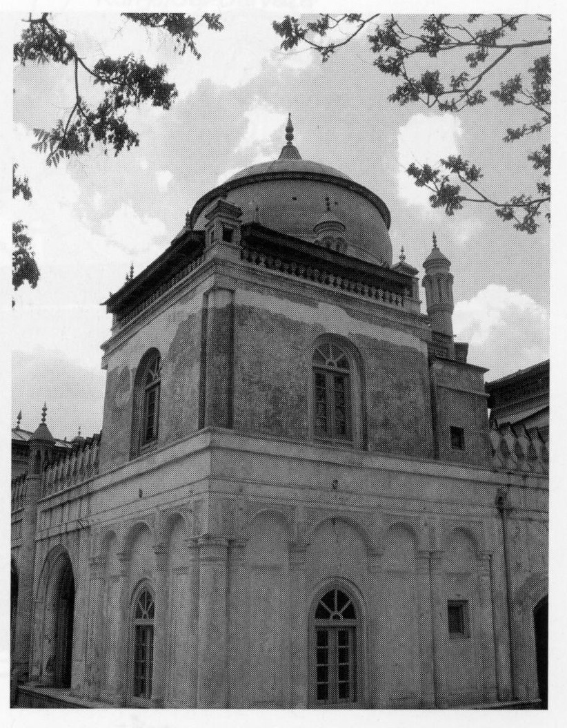
Outside the Arg walls, on the south side, on the western side of the park known as the Bāḡ-e Zarnegār, is the mausoleum of Amir ʿAbd al-Raḥmān Khan (d. 1901; Bell, p. 142; Dupree, pp. 67-68; Ḵalil, pp. 165-68; Schinasi, pp. 82-83 and pl. 6). Completed in 1892, it was known originally as the Bostān Sarāi, a semi-private palace (Martin, pp. 36-38). It incorporates elements of both European and Mughal architecture. Made of red brick, a material favored by the Amir, the entrance on the south is through a vaulted space with similar verandas on the east and west facades, with repeated, shuttered windows in the latter (AKTC, no. 12, 2008, p. 1; Schinasi, p. 82, pls. 5, 6). The central dome, corner towers and finials were added when the building was transformed into a mausoleum in 1902-05 (see PLATE III; Dupree, pp. 67-68; Ḵalil, pp. 165-66; Schinasi, p. 111). At the same time a mosque was added on the west (Schinasi, p. 111). The mausoleum was badly damaged by a British bomb in 1919 (Adamec, p. 117). On the west side of the Bāḡ-e Zarnegār is the Golistānsarāi, a small, single-storey, square palace built for the Amir’s queen, Bibi Ḥalima. It is said to have been designed by a Bukharan architect. Sections of original foliate stucco and carved wooden doors and frames still survive (Dupree, pp. 769-70; Schinasi, pp. 82-83 and pl. 1).
The Šahr Ārā palace and garden, in the modern district of the same name in northern Kabul, was constructed in 1899-1900 and was named after the Mughal garden of the same name, which was located on the left (north) bank of the Kabul river (Dupree, p. 128; Schinasi, pp. 32-33, 89 n. 105; Tūzuk-i-Jahāngīrī, I, p. 106). Much of the late 19th-century palace and gardens is overbuilt, partly by the Malalāy women’s hospital and the barracks to the east. An octagonal red brick tower, the Borj-e Šahr Ārā, and a fortified gateway, now used as the entrance to the barracks, as well as sections of the walls, in poor condition, have survived (Ārām, pp. 62-66; Schinasi, p. 89 and pls. 10-11). The religious center of ʿAbd-al-Raḥmān Khan’s new city was the ʿId Gāh mosque, built between 1894 and 1897 (Schinasi, p. 99) on the right (south) bank of the Kabul river. One of the largest mosques in Kabul city, it is still used for major religious festivals and state occasions. Conceived on a vast scale, the open, paved courtyard accommodates thousands of worshippers. Behind the courtyard, the entrance of the mosque proper was dominated by three red brick, arched halls (iwāns; see AYWĀN) and flanked by a colonnade of arches with minarets in neo-Mughal style (Bell, pp. 144-45; Schinasi, pp. 99-100 and pl. 18).
Amir Amān-Allāh Khan (r. 1919-28) also was a prolific builder. A Europhile and ‘modernizer,’ he set out to create a capital city worthy of a newly-independent kingdom and decided to shift the center of government from the old city to a semi-rural site in southwest Kabul that he named Dār-al-Amān (Samizay, p. 36; Schinasi, pp. 151-61, see fig. 10 for ground plan). This grand and expensive scheme, however, was never completed. The complex of buildings and formal gardens, some of which still survive, is centered on two vast buildings. To the east is the Qaṣr-e Amānia palace, designed by the French archeologist, A. Godard (Dupree, p. 85; Schinasi, pp. 155-59). This imposing and monumental two-storey, domed building is described by Byron as “a French municipal building” (Byron, pp. 272-73; see Schinasi, pp. 159-61). To the west is the Amir’s palace at Tepe Tāj Bēg, the interior of which was once lavishly ornamented with lapis lazuli and imported European marble (Dupree, pp. 87-89; Schinasi, pp. 157-58). Both buildings were gutted and looted during the fighting of 1992-95 and remain as mere burnt-out shells.
Bibliography
General works.
Ludwig W. Adamec, Historical and Political Gazetteer of Afghanistan VI. Kabul, Graz, 1985 (reprint of 1910 Gazetteer of Afghanistan with annotations and maps).
Idem, Afghanistan, 1900-1923. A Diplomatic History, Berkeley and Los Angeles, 1967.
[AKTC] Aga Khan Trust for Culture, AKTC – Afghanistan Newsletter (reports on restoration of Baḡ-e Bābor, Timur Šāh’s tomb, and the Old City). F. Raymond Allchin and Norman Hammond, eds., The Archaeology of Afghanistan from earliest times to the Timurid period, Cambridge, 1978 (brief descriptions of monuments in context of historical development).
Warwick Ball (with the collaboration of Jean-Claude Gardin), The Archaeological Gazetteer of Afghanistan: Catalogue des sites archéologiques d’Afghanistan, 2 vols., Paris, 1982 (list of Kabul city sites; some appear under “Kabul,” others as distinct sites).
Idem, The Monuments of Afghanistan, History, Archaeology and Architecture, London, 2008 (updating and revisiting of the 1982 Gazetteer with inclusion of photographs).
P. E. Caspani, “La promenade archéologique de Kaboul,” Afghanistan 1/4, 1946, pp. 35-43.
Nancy Hatch Dupree (in collaboration with Ahmad Ali Kohzad), An Historical Guide to Kabul, Kabul, 1972, 2nd ed. (a general guide to Kabul’s monuments).
Nancy Hatch Dupree, Louis Dupree, and A. A. Motamedi, The National Museum of Afghanistan, An Illustrated Guide, Kabul, 1974 (descriptions and illustrations of Buddhist sculpture from Kabul).
Government of India, “Kabul,” in Gazetteer of Afghanistan IV, 4th ed., Calcutta, 1910 (brief descriptions of major monuments compiled from descriptions of European explorers and travelers).
Jonathan Lee, The ‘Ancient Supremacy’: Bukhara, Afghanistan & the Battle for Balkh, 1731-1901, Leiden, 1996.
Mohammad Rafi Samizay, Urban Growth and Residential Prototypes in Kabul, Afghanistan, Cambridge, Mass., 1974 (examination of Old City, bazaars, and history).
May Schinasi, Kaboul, 1773-1948, Naissance et croissance d’une capital royale, IsMEO Series Maior XIII, Napoli, 2008 (focuses particularly on Mughal and Dorrāni period, inventory of monuments and Dorrāni royal graves).
[SPACH] Society for the Preservation of Afghanistan’s Cultural Heritage, Newsletter (brief reports on state of some of Kabul’s monuments). Francine Tissot, Catalogue of the National Museum of Afghanistan, 1931-1985, UNESCO Art, Museums and Monuments Series, Paris, 2006.
Collections of photographs, sketches, and drawings.
James Atkinson, Sketches from Affghanistan, London,1842a (these sketches accompany his descriptions in Idem, 1842b).
Paul Bucherer, ed., Photographs by the Photographic School of Bengal Sappers and Miners, Liestal, 1996 (reproduction of photographic album of the Bengal Sappers and Miners entitled Photographs of Kabul and its Environs and Photographs of Kabul Workshops, of the Defences round Kabul and Sherpur, 1879-1880 (British Library, India Office Select Materials, Photo 197/1-66 and Library & Archive of the Royal Corps of Engineers, Album J1, 6/256).
R. Burford, Description of a view of the City of Cabul the capital of Affghanistan, with the surrounding Country, London, 1842.
John Burke, Afghan War Album, 1878-79, British Library, India Office Select Materials, Photo 430/3 (1-114). (Burke’s catalogue had its own internal numbering, which appears on each actual image. This number does not coincide with the hand list of Photo 430/3. Burke’s reference number is followed by the relevant Photo 430/3 accession no. in the text. This series of images include the Bālā Ḥeṣār, Bābor’s Gardens, and a plan of Kabul city).
Lillias Hamilton, photographs, 1893-95, Archive & Manuscripts of the Wellcome Institute for the History of Medicine, PP/HAM/A.31/1,4,5,10,14 (photographs of Bālā Ḥeṣār, Dorrāni dynastic and nationalistic monuments).
Omar Khan, From Kashmir to Kabul, the Photographs of John Burke and William Baker, 1860-1900, Ahmedabad, 2002 (reprints of Burke’s photographs of the Bālā Ḥeṣār).
Charles Masson, “Miscellaneous drawings of Afghanistan, Sind and North-Western Provinces . . . ,” 1833-38, British Library, India Office Records, Mss Eur G40. (Numbers in text relate to BL accession numbers for the individual sketch and not folio number. The series includes sketches of Buddhist sites in and around Kabul, the Bālā Ḥeṣār, Bābor’s Gardens.)
Oskar von Niedermayer and Ernst Diez, Afghanistan, Leipzig, 1924 (the series of photographs of the Bāḡ-e Bābor are of particular importance).
James Rattray, The Costumes of the various tribes, portraits of the ladies of rank, celebrated princes and chiefs, views of the principle fortresses and cities and temples from Afghaunistaun, London, 1848.
Buddhist and other pre-Islamic monuments.
J. Carl and J. Hackin, “Le monastère bouddhique de Tépé Marandjān,” in Diverses recherches archéologique en Afghanistan (1933-1940), ed. J. Hackin et al., MDAFA [Mémoires de la Délégation archéologique française en Afghanistan] VIII, Paris, 1959, pp. 7-1, figs. 1-20 (not consulted).
Gérard Fussman (with collaboration of Baba Murad and Éric Olliver), Monuments Bouddhiques de la Région de Caboul II/1. Inventaire et descriptions (comprehensive inventory of Buddhist monuments in Kabul city and province with excavation reports), II/2. Planches, résumes, index, MDAFA 22, Paris, 2008.
Gérard Fussman and Marc Le Berre, Monuments Bouddhiques de la Région de Caboul 1. Le Monastère de Gul Dara, MDAFA 22, Paris, 1976.
P. Hulin, “The Signs on the Kabul Silver Piece,” Numismatic Chronicle, 6th series, 14, 1954, pp. 174-76.
E. Jacquet, “Notice sur les découverts archéologiques faites dans l’Afghanistan par Martin Honigberger dans l’Afghanistan,” Journal Asiatique, 1836/7, pp. 385-404.
Charles Masson and Horace Hayman Wilson, Ariana Antiqua, a descriptive account of the Antiquities and Coins of Afghanistan with a memoir on the buildings called Topes, London, 1841; repr. New Delhi, 1998 (sketches of Buddhist stupas in Kabul city and province).
Bālā Ḥeṣār and city walls. P. E. Caspari, “Les Murs de Kabul,” Afghanistan 1/2, Kabul, 1946, pp. 33-36.
[DAFA] Délégation Archéologique Française en Afghanistan and Institut National d’Archéologie Afghanistan, “Le Bala Hissar de Kaboul, Rapport d’évaluation archéologique 31 Mars – 8 Avril 2008” (unpubl.).
Alison L. Gascoigne and David C. Thomas, “Medieval Ghur Archaeological Project – End of Season Report, 2007” (unpubl., internal report).
Jonathan Lee, “The Armenians of Kabul and Afghanistan,” in Cairo to Kabul. Afghan and Islamic Studies presented to Ralph Pinder-Wilson, ed. Warwick Ball and L. Harrow, London, 2002, pp. 157-62.
Lt. J. L. D. Sturt, “Plan and Survey of the Bala Hissar or Fort of Cabul, showing the present state and nature of its defences . . . ,” 13 December 1839; published (in small scale) in Woodburn, pp. 8-9, fig. 5.
This large-scale plan (approx 1 inch = 200 ft) was reprinted as a lithograph in December 1878 (copy at Public Record Office, FO 925/2144).
Brig. C. William Woodburn, The Bala Hissar of Kabul, Revealing a Fortress-palace in Afghanistan, The Institution of Royal Engineers Professional Paper 1, Chatham, 2009 (the most comprehensive study to date; includes discussion of fortifications, interior structures, including axonometric reconstructions of the Mughal complex of Lower Bālā Ḥeṣār, historic plans, photographs and sketches).
Timurid and Mughal period. L. Bogdanov, “The Tomb of the Emperor Babur near Kabul,” Epigraphia Indo-Moslemica 23, Calcutta, 1923-24, pp. 1-12 (inscriptions at Bābor’s tomb).
[DAI] Deutsches Archäologische Institut, “Afghanistan: Kabul, Bagh-e Babur,” at http://www.dainst.org/index_37335c29bb1f14a165540017f0000011_en.html (accessed 7 July 2009).
M. J. Darmesteter, “Inscriptions de Caboul, epitaphes de l’Empereur Bâbur et d’autres Princes Mogols,” Journal Asiatique 11, 1888, pp. 491-503.
Ute Franke-Vogt, K. Barti, and Th. Urban, “Bagh-e Babur, Kabul: Excavating a Mughal Garden,” in South Asian Archaeology, Proceedings of the 17th International Conference of the European Association of South Asian Archaeologists 7-11 July 2003, ed. U. Franke-Vogt and Hans-Joachim Weisshaar, Bonn, 2005, pp. 541-55 (German excavations in Bābor’s Gardens, 2002 to 2004 seasons).
A. V. Williams Jackson, “The Tomb of the Moghul Emperor Babur in Afghanistan,” Proceedings of the American Philosophical Society 68/3 1929, pp. 195-205 (discussion of Bābor’s tomb, Šāh Jahān’s mosque and inscriptions).
Moḥammad Ebrāḥīm Ḵalīl, Mazārāt-e šāhr-e Kābol, Kabul 1339 Š./1960 (survey of tombs and shrines, including Timurid and Mughal tombs with inscriptions).
Jonathan L. Lee, “The Ziyārat of Khwāja Zanbur and its associated Shāh Jahān mosque, or shrine, in Kābul,” AIUON 45/2, 1985, pp. 193-97.
Jolyon Leslie, Babur’s Garden Rehabilitation Framework, Aga Khan Trust for Culture, Kabul, 2004.
Nur-al-Din Moḥammad Jahāngir Gurkani, The Tūzuk-i-Jahāngīrī, or Memoirs of Jahāngīr, tr. Alexander Rogers, ed. Henry Beveridge, 2 vols., London, 1909-19; repr., New Delhi, 2006, 2 vols. in one.
Maria Teresa Shephard Parpagliolo, Kābul. The Bāgh-i Bābur: a Project and a Research into the Possibilities of a Complete Reconstruction, IsMEO Restorations II, Rome, 1972.
Ahmad Šakib Sāleq, “Čahār Čatta-ye Kābul” Bāstān-šenāsi 6/2, Kabul, 1361 Š./1982, pp. 5-12 (not consulted).
Lidia Sannino, “Un Monumento Moghul da Recuperare: il Recinto Funerario di Ruqaya Sultan Began nel Bagh-e Babur a Kabul,” AIUON 45/1, 1985, pp. 49-73 (review of European descriptions of tombs, discussion of which tombs were enclosed by the screen).
Ẓahir-al-dīn Moḥammad Bābor, Bābor-nāma, tr. A. S. Beveridge, Leiden, 1905; repr., Lahore, 1975.
Salome Zajadacz-Hastenrath, “A Note on Babur’s Lost Funerary Enclosure at Kabul,” Muqarnas 14, 1997, pp. 136-42.
Giuseppe Zander, “L’IsMEO e i restauri di monumenti,” Il Veltro 16/5-6, 1972, pp. 576-89 (overview of Italian restoration).
Dorrāni dynastic monuments. Moḥammad Išān Ārām, “Ābed-e borj-e Šāhrārā qabl az tarmīm,” Bāstān-šenāsi 7/1, Kabul, 1364 Š./1985, pp. 62-66.
Travel writings and military memoirs. Rev. J. N. Allen, Diary of a March through Sinde and Affghanistan, London, 1843 (description of the Bālā Ḥeṣār and the lost Armenian church).
James Atkinson, The Expedition into Affghanistan: notes and sketches descriptive of the country contained in a personal narrative during the campaign of 1839 and 1840, London, 1842b (descriptions to accompany his Sketches).
M. J. Bell, An American Engineer in Afghanistan, Minneapolis, 1948; 2nd repr., Kabul, 2004.
Alexander Burnes, Travels into Bukhara: being an account of a Journey from India to Cabool, Tartary and Persia, vol. 1, London, 1834; repr., New Delhi, 1992.
Robert Byron, The Road to Oxiana, London, 1937; repr., London, 1981.
René Dollot, L’Afghanistan, Paris, 1937.
George Forster, A Journey from Bengal to England through the northern parts of India, Kashmire, Afghanistan and Persia and into Russia by the Caspian Sea, 2 vols., London, 1808 (pagination in text refers to this edition only).
John Alfred Grey, My Residence at the Court of the Amir, London, 1895; repr., London, 1987.
Maj. W. Hough, A Narrative of the March and Operations of the Army of the Indus in the Expedition to Affghanistan in the Years 1838-1839, London, 1841.
John Kaye, History of the War in Afghanistan, 2 vols., London 1851; repr., Delhi, 1999.
Richard Hartley Kennedy, Narrative of the Campaign of the Army of the Indus in Sind and Kaubool in 1838-9, 2 vols., London, 1840.
Maj. Gen. Sir Charles Metcalfe MacGregor, War in Afghanistan, 1879-80, ed. William Trousdale, Detroit, 1985.
F. Martin, Under the Absolute Amir, London, 1907; repr., Lahore, 1998.
Charles Masson, Narrative of Various Journeys in Balochistan, Afghanistan and the Panjab, including a residence in those Countries from 1826 to 1838, 3 vols., London, 1842 (descriptions of Bālā Ḥeṣār, Bāḡ-e Bābor, and excavations of Buddhist sites); repr., New Delhi, 1997.
Maj. Reginald C. W. Mitford, To Caubul with the Cavalry Brigade, London, 1881; repr., Lahore, 1999 (1st ed. has a unique [?] sketch of the interior of Čahār Čatta bazaar before its destruction in 1842).
Maj. Gen. Sir G. S. Montcrieff, Canals and Campaigns. An Engineer Officer in India, 1877-1885, London, 1987.
Lowell Thomas, Beyond the Khyber Pass, New York, 1925 (description of Baḡ-e Bābor and Šah Jahān inscription).
G. T. Vigne, Personal Narrative of a visit to Ghuzni, Kabul, Afghanistan and a residence at the Court of Dost Muhamed, London, 1840; repr., New Delhi, 2005.