

KĀRIZ
ii. TECHNOLOGY
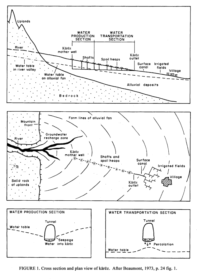
(1) Grade. The technology of kārēz exploits a difference in grade between a tunnel and the groundwater table. The grade of the tunnel is less steep than the grade of the water table (Figure 1), so that the tunnel ends at an elevation distinctly higher than that of the water table. Each tunnel consists of two sections: a supply or drainage section upstream penetrates the water table in order to capture the water, and an adduction section downstream is located above the level of the water table in order to transport the water to the land to be irrigated. In Iran the average grade may be around 0.5 percent (Goblot, 1979, p. 27), but between 1 and 2 percent in Oman (Weisgerber, p. 71). These gradients allow the water to flow while avoiding an erosion of the tunnel by too rapid a rate of flow.
(2) Length. In a few exceptional cases, the channels are quite long. The known maximum lengths are some 50 km in the region of Yazd (Beaumont, 1989, p. 23) and about 35 kilometers at Gonābād in Khorasan (Goblot, 1979, pp. 35-36). But the vast majority of channels are much shorter. In the 1960s, Peter Beaumont (1971, pp. 42-44 with fig. 3; 1989, pp. 21, 23) examined more than 2,000 channels in 12 different networks in Iran and calculated that 36 percent had a length between 0.5 and 2 km, while only 16 channels, which is less than 1 percent, were longer than 15 km. In Afghanistan the channels seem to be still shorter. Out of a group of 157 kārēz, the average length was 1.7 km, and only 3 channels surpassed 4 km, with a maximum of 5.3 km. The maximum length known for an Afghan kārēz is a channel 20 km southeast of Gazni (Balland, 1992b, p. 106).
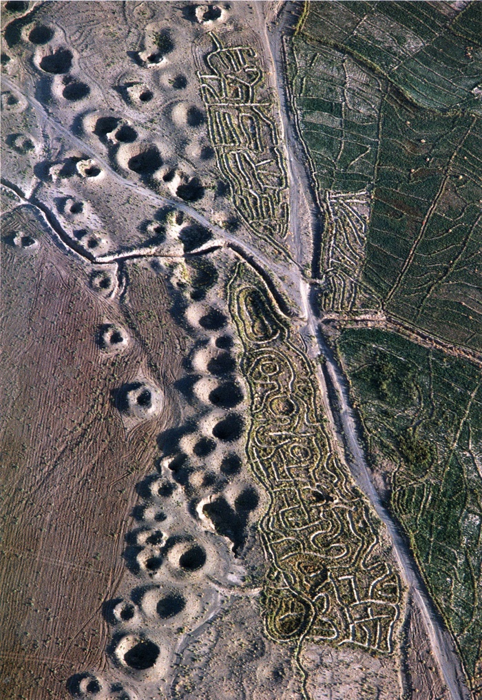
(3) Vertical shafts. The channel is the essential functional element of the kārēz, but vertical shafts, which connect the tunnel to the surface, are needed for digging the tunnels and play no role in the actual operation of the kārēz. The vertical shafts are laid out at more or less regular intervals, which are relatively close in order to facilitate the removal of debris. In Iran, the average interval might be on the order of 20 to 30 m. Good planners, in order to assure the profitability of their work, try not to increase their number too much and dig the shafts with the greatest possible distance between them, at times from 50 to 100 m (Goblot, 1979, p. 36). The alignment of the chains of shafts, whose circular openings are marked by small mounds of debris and which are clearly visible, in particular to aerial observers, are one of the most spectacular and characteristic features of the Iranian landscape (PLATE I, PLATE II).
In the great majority of cases a shaft is not sunk down deeper than 50 m (Beaumont, 1989, p. 23). In the region of Tehran shafts are sunk down as deep as 150 m, and in one exceptional case in Gonābād in Khorasan, a shaft has a depth of 300 m, which is obtained by a system of three shafts, roughly superposed along the same vertical line, but separated by landings at intervals of around 100 m until the water table is reached (Goblot, 1979, pp. 35-36).
(4) Construction. The work on a kārēz (Goblot, 1979, pp. 30-36) begins with a survey of the probable existence of a water table uphill on the slope. There are various indicators of a water table, which are usually found near its natural outlet. An exploratory shaft (gamāna; cf. gamānidan “to think, to believe”) is sunk down to the level where one hopes to reach the water. When the shaft hits the water table, the gamāna is used as the uphill head of the channel and will be called the mother well (māder čāh). The water immediately begins to seep through the base and sides of the shaft, but the worker has time to rapidly dig several meters of the water-bearing channel before the bottom of the shaft is flooded, since generally the seepage is slow. When the soil has become too moist to continue working underground, the worker returns to the surface. Several days are required for the stabilization of the water level, and it is impossible to continue the work from the mother well, since the channel would be completely flooded. The excavation of the channel is therefore paused for several days after the digging of the mother well, and it must always be continued from the proposed location of the outlet downstream. The determination of the outlet is an essential element of the construction process. Its location follows from that of the areas to be irrigated, but the outlet must also be situated on a contour line compatible with the normal flow of the water at its elevation at the bottom of the mother well. Precise surveying is thus necessary.
In the 19th and 20th centuries, modern surveying methods relied on a spirit level equipped with a telescope, and on a surveyor’s rod carried by an aide. The traditional empirical methods were more or less complex. As they had been practiced for a very long time, they were occasionally still employed in the 20th century. In the 1950s Anthony Smith (1957, pp. 92-93) observed a traditional surveying method in the region of Kerman. The process begins with gauging the depth of the mother well with a plumb line. Afterwards a second line is attached to the rim of the mother well, while the other end of it is tied to a stake held by an aide, who moves away in the approximate direction of the channel. When the line is almost taut, the stake is fixed in the ground. The taut line is then wetted, and if the drops of water flow neither in one direction nor the other, the line is considered to be horizontal. The third step is to mark the distance between the ground and the point at which the line is attached to the stake with a knot on the plumb line of the mother well, starting from the top. These three steps are repeated until the end of the plumb line is reached. The last point on the slope downstream where the stake has been fixed in the ground is then at the same elevation as the bottom of the mother well, as well as approximately at the same level as the water table.
A slightly more refined method, involving the aid of mechanical device, was described by M. A. Butler in the early 1930s, although Henri Goblot (1979, p. 33) stressed that he himself had never seen this device. It was known from experience, independent of any mathematical demonstration, that the four corners of a square are right angles; that is, the four sides are perpendicular to each other. A square is constructed from four wooden laths of the same length, and rings are fixed at the four corners. A plumb line is attached to one of the corners to determine the vertical, and to mark the horizontal a rather long rod is passed through the two rings, left and right of the corner with the plumb line. The device is then positioned above the opening of the shaft with the help of a small derrick, so that one can take a sighting on a surveyor’s rod held by an aide (Figure 2).
This operation is repeated until the sum of the resulting measures of successive sightings is equal to the depth of the shaft. In order to avoid the addition of sums, the results of the sightings are transferred to the plumb line, measuring the depth of the shaft with the aid of knots, as in the preceding method.
Once the survey has established the starting point for the channel’s excavation, its course is laid out on the surface of the ground up to the mother well. The open-air channel becomes a tunnel as soon as it diverges from the surface by 2 meters. It is essential that the tunnel follows a straight line, on the course laid out above ground. The worker traditionally uses an oil lamp, which is hung from the ceiling to ensure that he is digging straight. In the working area the lamp casts a shadow, which must remain continually in the center of the leading face of the tunnel. To further facilitate the worker’s staying on the tunnel’s set course, two plumb lines are hung into each excavation shaft, to the end of which a rod is attached. The direction of the rod parallels the course of the tunnel as marked above ground. The gradient is obtained by a suspended square, with a line attached to the top; one mark at the horizontal and two marks on each side indicate the maximum slope allowable. As the worker progresses upstream, he digs a furrow, which will serve to drain the water along the tunnel’s base. In order to avoid loss by percolation, the furrow can be lined with a mortar (šefta) containing lime. All this work is carried out with classical miner’s instruments, such as a pickaxe and a winch for hauling out debris.
When the channel has been completed, the workers seek to increase its output, if possible. One method is to enlarge the surface area where seepage occurs in the part of the channel supplying the water, either by extending it upstream beyond the mother well or by digging side-tunnels, which join the main channel in a fishbone pattern or converge on a single shaft in the shape of a star (Goblot, 1979, pp. 34-35). Another method is to construct a second channel below the first one, so that water lost through infiltration from the upper channel can be reclaimed. The kārēz in Gonābād, cited previously, and of Mon, near Ardestān seems to have been planned in this way from the start (cf. Safi-Nežād, 1992, pp. 64-65). In the majority of cases, however, it is most probable that the lower channel was constructed later, when depletion of the water table had rendered the upper channel unproductive.
The tunnels require very careful maintenance, which includes more or less frequent repair of collapsed walls and ceiling and a cleaning of the pores through which water from the water table percolates, whenever they are blocked by sediment. When the walls are highly degraded, they are reinforced by rings of baked clay (kaval), on average 1.2 m high, 0.5 m wide, and 0.2 m thick, which can fit into each other to create a continuous surface (Goblot, 1979, p. 35 and pls. 8 and 10 after p. 48).
(5) Channel worker. The kārēz construction technique is on the whole quite complex despite its often primitive character. Therefore, the work of those who are digging the channels (Ar. sing. moqanni, lit. “he who makes a qanāt”) is highly specialized and dangerous. The technique has been developed to perfection in Iran, but outside the Iranian cultural area of Afghanistan, Central Asia, and India, it is generally much less refined and more imperfect (Goblot, 1979, p. 36).
In Iran the channel workers are organized into actual guilds. In order to facilitate the formation of work crews under the command of experienced foremen, the channel workers live together—whether in the countryside, in their own villages, or in cities such as Tehran, Yazd, Nayin, and Kerman—in their own quarters (Goblot, 1979, p. 46; English, 1966, p. 136). The channel workers devote almost all of their time to their main responsibilities of building new kārēz and maintenance of operating kārēz. Occasionally they do a little gardening or excavate cesspools. The work on cesspools, which until the recent introduction of modern sewers were necessary for waste disposal, demands skills that are related to those needed for the construction of kārēz. Each house used to have its own cesspool, and in general they had an average depth of about 30 m. The channel workers also cleared the filled cesspools, and after some years the consolidated waste was used as fertilizer.
The moqanni work crews are hierarchically organized, since the specialized workers have very different skills and are divided into five distinct groups. Above the ground the most important person is the čarḵ keš (čarḵ “wheel”; kešidan “to draw, to pull”), who operates the winch and lowers the empty bucket to the shaft’s bottom. He is assisted by a worker responsible for emptying the bucket. Underground the kolang dār (kolang “pickaxe”) is in charge, because he determines the direction and dimensions of the future channel and the excavation by pickaxe, as well as all the evacuation shafts. He is assisted by two workers, one who fills the bucket with debris and one who repeatedly carries the debris to the winch. Their salaries are quite hierarchical and have become more and more strongly differentiated in the 20th century (Safi-Nežād, 1992, pp. 60-61). The number of workers employed varies according to section. Five channel workers are employed in the supply section upstream, where the labor is more complicated, and the number can be limited to just 3 men in the downstream section. Up to 10 crews are employed simultaneously at a site in order to complete the construction within the period of one to two years, which generally seems to be considered a reasonable time frame. The case of a kārēz at Ray, where a single crew needed 10 years to construct a 6-km channel, seems to be an exception (ibid., p. 62).
In Afghanistan, fewer men are trained as moqanni, and they seem to be less hierarchically organized than those in Iran. Work crews are often employed far away from their homes; in certain cases there are several hundred kilometers between their homes and their construction sites. In the 1950s, the channel workers in the districts of Quetta and Qalāt were Pashtuns of the Ḡalzi tribal federation (see ḠILZI) who came from a village in the neighborhood of Kandahar (Goblot, 1979, p. 47, n. 6).
(Xavier de Planhol)
Originally Published: December 15, 2011
Last Updated: April 24, 2012
This article is available in print.
Vol. XV, Fasc. 6, pp. 565-569
Xavier de Planhol, “KĀRIZ ii. TECHNOLOGY,” Encyclopædia Iranica, XV/6, pp. 565-569, available online at http://www.iranicaonline.org/articles/kariz_2 (accessed on 30 December 2012).