


iv. Archaeology
The plain of Gorgan, situated on the southeast shore of the Caspian Sea, has always been regarded as an important region for its archeological deposits dating from the pre-historic to the Islamic period.
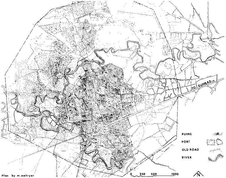
Figure 1. Aerial map of the old city of Gorgān (Jorjān). (Courtesy of the author.)
The Greek historian Arrian, recording Alexander’s expedition to the East, speaks of Alexander’s march to the city of Zadracarta, the largest town in the region and the capital of Hyrcania, where the royal palace was situated. It has been suggested that the present city of Gōrgān, formerly Astarābād/Estrābād, could possibly be the ancient Zadracarta (Frye, p. 720; Sykes, p. 17). A more plausible suggestion for the location of Zadracarta seems to be the site of Qalʿa-ye Ḵandān. It is a large tepe measuring 300 x 220 m with a height of about 40 m, located on the southwest corner of the city of Gorgān on the road to Sāri. A Seleucid inscription from the reign of Antiochos I (281-261 B.C.E.), discovered in Gorgān, probably came from this very site (de Morgan, pp. 107-8; Robert).
Abu’l-Fażl Bayhaqi (ed. Fayyāż, p. 585), in his account of the Ghaznavid Sultan Masʿud’s expedition to the Caspian coast, reports that the royal tent was pitched on a high place (bālā) outside Estārābād, which may be the same location now known as Qalʿa-ye Ḵandān. In such case this site must date from the pre-Islamic period, since it had already become a tepe in the 5th/11th century, which lends more weight to its identification as the ancient Zadracarta.
More information is provided by Polybius and Strabo. Polybius (10.31.3-10) mentions the camp of the Hyrcanian commander in a place called Sirynx, not far from an unwalled city called Tambrax. Strabo (11.7.2) refers to Tapē as the royal residence and describes it in terms similar to that of Sirynx by Polybius. It has been suggested that the archeological site of Qara Tapa, located 7 km west of Behšahr (q.v.), could be identifiable with Tapē of Sirynx (see Stahl).
Gorgān Plain enjoyed a prosperous period of development under the Parthians, who built new forts and cities there and converted many of the earlier ones to meet their own needs, which was mainly for military purposes. Forts and cities built during the Achaemenid and Seleucid periods usually had a rectangular or polygonal layout. The foundations of the Parthian period could, however, be polygonal (early Parthian, e.g., Nisa, Solṭān-ʿAli, Dašt Qalʿa), oval, circular, or rectangular/square (e.g., Qalʿa Daland, Gabri Qalʿa, and Qalʿa Ḵarāba). Remains of many such constructions are still visible in Gorgān, mainly in the eastern part of the Caspian region.
Ture Johnsson Arne noted 233 sites of archeological significance on the Gorgān plain. Recent excavations and research provide fresh evidence on the activities of the Parthians in this region. A survey expedition from the Iranian Archeological Center identified many archeological sites, particularly of the Parthian and Sasanian periods; they could not, however, be identified with any of the disappeared cities of the period (Kiani, 1982a; idem, 1982b).
A large find of bullae was made in uncontrolled conditions at Kabudān Tepe to the east of Gorgān City (Astarābād/Estrābād), several of which are now kept at the Archeological Museum (Muza-ye Irān-e Bāstān) in Tehran. Some were reported by Maleka Malekzada Bayani, who was able to identify the find-spot (Malekzada Bayani, pp. 218-21). Specimens apparently of the same origin were discussed by Richard Nelson Frye (1972, pp. 272-75), and others seem to have entered the Bibliothèque Nationale in Paris. The central field of the impression contains the province named Gorgān, and the margin designates the office of the solicitor-judge of the poor (driyōšān ǰādag-gō ud dādwar; for the functions of this official see Gignoux, 1978, pp. 5-6). Other examples apparently from the same find-spot give the same province name, abbreviated as GWL, in the area of the inscription, and a marginal inscription that has been variously deciphered as Gwl’n str “Gorgān province,” or more recently as Gwlkʾn strp “Satrap of Gorgān.” The two formula seem to occur in different contexts; thus the accuracy of the reading remains open to question until critical inspection of the well-preserved specimens are made. Both words seem to be followed by a sequence of circles, the first of which can easily be confused with the letter “p.” On another specimen from Kabudān Tepe, Philippe Gignoux has corrected the earlier interpretation of the area legend wlwʾk, followed by the familiar mgwḥ, as a personal name, and pointed out that it must designate a settlement in the vicinity (Gignoux, 1973, p. 142).
The Sasanian coin series indicate that the provincial center had also the new name Gorgān (Mochiri, p. 88). It appears as a mint city in an abbreviated form GW from the period of the Sasanian Yazdegerd II (439-57; Paruck, pp. 153-54). It is to be presumed, however, that the site of the Sasanian capital city was close to the Islamic archeological site of Gorgān, near the modern city of Gonbad-e Qābus (q.v.), although direct evidence for an identification is lacking (at present, the name Gorgān has been transferred to the modern providence capital, 50 miles to the southeast, the former Astarābād).
Three bullae from Turang Tepe give a further toponym for Gorgān province, Husraw-šād-Pērōz, which is shown by the marginal legend Gwlgʾn to belong to that region. The same toponym is also known for the Sasanian province of Iraq. Gignoux (1974, p. 301) suggested that this could be the Sasanian designation of Turang Tepe. Islamic sources mention a few other Sasanian cities in the province, such as Rowšan-Firuz, situated on the road from Gorgān to Khorasan (Ṭabari, I, p. 874; Balʿami, ed. Bahār, pp. 954-55). Many of these historical points have been supported by archeological evidence (Gyselen, pp. 189-212).
An outstanding Sasanian structure in the province is a ruined fire temple in the region of Robāṭ-e Qarabil between Gonbad-e Qābus and Bojnurd in Khorasan. It is situated a few kilometers north of the road from Robāṭ-e Qarabil to Čamanbid (Chassagnoux, pp. 261-65). The building is of the usual Sasanian type, and to the local inhabitants is known as the Church of Espaḵu (Kelisā-ye Espaḵ; Moqri, p. 92).
By far the most important archeological site in Gorgān is the mud-brick, defensive wall mistakenly known as Alexander’s Wall (Sadd-e Eskandar), which runs for about 180 km eastward from the sea to the hills of Piškamar as a rampart against invaders from the north (Kiani, 1982b). It is also called Sadd-e Anuširvān and Sadd-e Piruz in Persian, and is known as Qïzïl Yïlan to local Turkman inhabitants (see fortifications). The excavation carried out by the team from the Iranian Archaeological Center revealed the remains of Parthian structure that was rebuilt by the Sasanians. If the wall was originally built, as has been suggested (Kiani, 1982a, pp. 11-38), in the reign of Mithradates (Mehrdād) II (123-87 B.C.E.), then it would mean that the city of Nisa had by then lost much of its importance for the Parthians; therefore, the main center of their power in the northeast, as well as the location of their major cities at that time, must have been in the Gorgān plain. Although many of the sites remain unexcavated, most of them can be attributed to the Parthian period, and some can be identified with major Parthian towns. It is noteworthy that many of them show considerable similarity in their general layouts with the forts and cities of Central Asia.
The building materials which were used consist of mud brick, fired brick, gypsum, and mortar. Clay was also used during the early Parthian period. It seems that in the early period greater use was made of mud-bricks in the construction of forts and cities, whereas the use of fired bricks, with varying degrees of hardness, became popular in the later period. More often than not, one brick was set in the vertical position, with two horizontal rows of bricks laid above and below. This arrangement was used in the construction of the defensive wall. The sizes of mud or fired bricks differ, but in general the standard size was 40 x 40 x 10 cms.
Bibliography
Ture Johnsson Arne, Excavations at Shah Tepé, Iran, Reports from the Scientific Expedition to North-western Provinces of China under the Leadership of Dr. Sven Hedin, The Sino-Swedish Expedition Publication 27, VII Archaeology 5, Stockholm, 1945.
Malekeh Malekzadeh Bayani, “Études sur quelques bulles sassanides,” in Akbar Tajvidi and Muhammad-Yusof Kiani, eds., The Memorial Volume of the Vth International Congress of Iranian Art and Ar-chaeology . . . 11th-18th April 1968, 2 vols., Tehran, 1972, I, pp. 218-21.
J. and A. Chassagnoux, “Atesh-Kadeh dans un Village Kurde pres de Robat-Qarehbil,” Stud. Ir. 4/2, 1975, pp. 261-65.
Richard Nelson Frye, “Astarābāḏòẖ,” in EI2 I, p. 720.
Idem, “Sasanian Seals and Sealings,” in The Memorial Volume of the Vth International Congress of Iranian Art and Archaeol-ogy . . . 11th-18th April 1968, 2 vols., Tehran, 1972, I, pp. 272-75.
Idem, “The Sassanian System of Walls for Defence,” in Myriam Rosen-Ayalon, ed., Studies in Memory of Gaston Wiet, Jerusalem, 1977.
Philippe Gignoux, Catalogue des Sceaux, Camées et Bulles Sasanides de la Bibliothéque Nationale et du Musée due Louvre II, Paris 1978.
Idem, “Problèmes d’interprétation des bulles sasanides,” Stud. Ir. 2/2, 1973, pp. 137-42.
Idem, “Nouveux toponymes sasanides,” JA, 1974, pp. 299-304.
Robert Göbl, Die Tonbullen von Takht-e Suleiman: Ein Beitrag zur spätsasanidischen sphragistik: Takht-e Suleiman, Berlin. 1976, Table 55, no. 11. 4.
André Godard, “Gurgān and the Gunbad-i-Qābus,” in Survey of Persian Art III, pp. 967-74.
Muhammad-Yusof Kiani, Parthian Sites in Hyrcania: The Gurgan Plain, AMI, suppl. 9, Berlin, 1982a.
Idem, “Excavations on the Defensive Wall of the Gurgān Plain: A Preliminary Report,” Iran 20, 1982b, pp. 73-79.
Idem, The Islamic City of Gurgan, AMI 11, Berlin, 1984.
Idem, Pāytaḵthā-ye Irān, 3 vols., Tehran, 1995.
Malek Iradj Mochiri, Etudes de numismatique Iranienne sous les Sassanides I, Tehran, 1972.
ʿAli-Aṣḡar Moqri, Banāhā-ye tāriḵi-eḴorāsān, Mašhad, 1359 Š./1980.
Jacques de Morgan, Mission scientifique en Perse, 5 vols., Paris, 1894-1905.
Furdoonjee D. J. Paruck, Sasanian Coins, Bombay, 1924, pp. 153-54.
Hyacinth Louis Rabino di Borgomale, Mázandarán and Astarábád, London, 1928; tr. Ḡolām-ʿAli Waḥid Māzandarāni as Māzandarān o Astarābād,Tehran, 1343 Š./1964.
Louis Robert, “Inscription Hellénistique d’Iran,” Hellenica 11-12, 1960, pp. 85-91, pl. V.
H. Shiomi, Archaeological Map of the Gorgan Plain, Iran, no. 1/2, Hiroshima 1976-77.
A. F. Stahl, “Notes on the March of Alexander the Great from Ecbatana to Hyrcania,” JRGS, 1928, pp. 312-19.
Percy M. Sykes, “A Sixth Journey in Persia,” The Geographical Journal 37, 1911, pp. 1-19, 149-65.
J. Walker, A Catalogue of the Muhammadan Coins in the British Museum: A Catalogue of the Arab-Sassanian Coins, London 1941.