


GĪLĀN
i. Geography and Ethnography
Physical Geography (Figure 1). Gīlān includes the northwestern end of the Alborz chain and the western part of the Caspian lowlands of Persia. The mountainous belt is cut through by the deep transversal valley of the Safīdrūd between Manjīl and Emāmzāda Hāšem near Rašt. To the northwest, the Ṭāleš highlands stretch a continuous watershed separating Gīlān and Azarbaijan. Except at their northern end, where the Ḥayrān pass at the top of the Āstārāčāy valley does not exceed 1600 m, they are over 2000 m high, with three spots over 3000 m, the Bāqrow Dāḡ (3197 m), the ʿAjam Dāḡ (3009 m), and the Šāh Moʿallam or Māsūla Dāḡ (3050 m). Their eastern and northeastern side is deeply carved by parallel streams flowing down towards the Caspian, resulting in a comb-shaped pattern. The western Alborz itself, to the east of the Safīdrūd valley, is wider and more intricate, with three parallel (WNW-ESE) ranges; the southernmost and lowest one is represented in Gīlān by the Āsmān-sarā Kūh (2375 m) in the ʿAmmārlū district; the medium one is the most continuous, from the Kūh-e Dalfak (2711 m) to the Keram Kūh (3389 m), whereas the transversal valley of Polrūd clearly divides the northern range into Kūh-e Nāteš (2387 m) and Kūh-e Somām or Somāmūs, the highest spot of Gīlān (3689 m). All these mountains have a very complicated geological structure and tectonic history which connects them to the structural complex of central Persia (Stöcklin). Continuing orogenic activity is attested by the relatively high seismicity; the earthquake of 20 June 1990 almost destroyed the two towns of Manjīl and Rūdbār, killed some forty thousand people and damaged several hundreds of villages.
Though all those mountains cover a greater area than the plains, these are the most specific feature of the province, and locally, the word Gīlān often refers to the plain areas or particularly to the central plain. This large parallelogram of lowlands, 35 km wide and 90 km long, is heterogenous and can be divided into two main parts: the delta of the Safīdrūd in the east and the Fūmanāt plain in the west. The former has been entirely built by the Safīdrūd, a river with a high discharge (450 millions m3 in average) and a high alluvial content. The higher part is made out of coarse ancient alluvial material, whereas in the lower part, north of Āstāna, the river often changed its course through thin silty and clayey material; it has thus abandoned its former northeastward course, which flowed into the sea at the prominent angle of the plain near Dastak, and presently flows northwards and builds a smaller living delta jutting out into the Caspian between Zībā Kenār and Bandar Kīā Šahr (formerly Ḥasan Kīāda and Bandar Faraḥnāz during the 1970s). The Fūmanāt plain to the west intermingles marine alluvial deposits and former sandy beachlines with abundant alluvial deposits from the numerous rivers draining the southern part of Ṭāleš highlands. They do not reach directly the sea, but converge into the lagoon (mordāb) of Anzalī (q.v.) with a single outlet to the Caspian through the dune-covered sandy coastline. The lagoon is constantly getting smaller and shallower under the effect of silting. On the contrary, the streams of northern Ṭāleš and eastern Gīlān, even the more abundant Polrūd, do not bring alluvium enough to counterbalance the action of a coastal current going eastward, and thus could not build more than a narrow ribbon of lowlands, only a few kilometers wide between Āstārā and Safīdrūd and to the east of Qāsemābād, and some 10 km wide at the mouth of the Polrūd around Kalāčāy.
Climate and vegetation. The topographic position of the Caspian lowlands results in a very characteristic “Hyrcanian” climate, and the whole province of Gīlān belongs to this exceptionally humid and green area (Adle; Djavadi; Ganji): Prevailing north-south atmospheric currents, humidified over the Caspian, are forced to a vigorous ascendancy by the mighty barrier of Alborz and thus pour all around the year abundant rainfall on both the plain and the northwestern slope of the mountains. The precipitation regime shows a sharp maximum in autumn (September to December), when atmospheric instability is at its highest point, medium values in winter and early spring, and lowest (but generally abundant enough to remain over the limit of “dry months”) values from May to August. Mean annual rainfall varies between 1200 and 1800 mm along the shoreline (1233 mm in Āstārā, 1755 in Anzalī), decreases towards a subhumid area in the southwestern corner of the plain (1086 mm in Fūman and 885 mm in Šāndarman), and reaches again very high amounts in the lower part of the mountain, up to 1500-1800 m (2400 mm in the upper Māsāl valley). Along the Safīdrūd valley, swept every afternoon in summer by the violent northerly “Manjīl wind” (Tholozan), a very rapid transition leads to the Mediterranean-like semi-arid area of Rūdbār and Manjīl (366 mm).
The climatic privilege of Gīlān explains its luxuriant natural vegetation. This Hyrcanian botanical region has specific features with regard to the Euro-Siberian territory, and even inside the Euxino-Hyrcanian botanical province (Bobek, pp. 16-21; Mobayen and Tregubov; Zohary, pp. 21-30): the almost complete absence of conifers, but very sparse yew-trees (sorḵ-dār), and the great number of endemic species which have survived from the Arcto-Tertiary flora. According to altitude, three forest levels can be distinguished: the Hyrcanian mixed forests, the mountain beech forest, and the high mountain oak and hornbeam forest. The Hyrcanian forest stricto sensu once covered the plains, where only residual patches remain on coarse alluvial terraces between cultivated areas, and still covers the greater part of the first slopes of the mountains up to about 1000 m. It is a stratified forest, with a layer of very tall trees such as the endemic chestnut-leaved oak (boland-māzū; Quercus castaneaefolia), Siberian elm (deraḵt-e āzād; Zelkova crenata) and iron tree (anjīlī; Parrotia persica) and more common elms, maples, and hornbeams (ūlas); a layer of smaller trees like the endemic Gleditchia caspica (līlakī), Diospyros lotus (kalhū), and Albizzia julibrissin (šabḵosb), boxwood (šemšād) in shady spots and all kinds of wild fruit trees; and an underwood with evergreen bushes such as Prunus laurocerasus (jal) and holly (ḵās), moss, wild vine, ivy, and other creeping plants. Medium altitude mountains are the realm of the lofty oriental beech (rāš; Fagus orientalis), associated with oaks (balūṭ), lime-trees (namdār), maples (afrā), and elms (nārvan; qq.v.). The upper mountain level, between 1800 and 2200 m, has remnants of a quite poorer forest of stunted oaks (ūrī; Quercus macranthera) and hornbeams (Carpinus orientalis). Alpine meadows, climacic at higher altitudes, have often replaced these upper mountain forests, some of them, on highest ridges or sheltered slopes, show distinctly xerophytic features. The so-called Mediterranean island around Rūdbār and Manjīl is conspicuous through its specific vegetation, natural as well as cultivated, i.e., its very sparse cypress (q.v.) forests and its olive-groves.
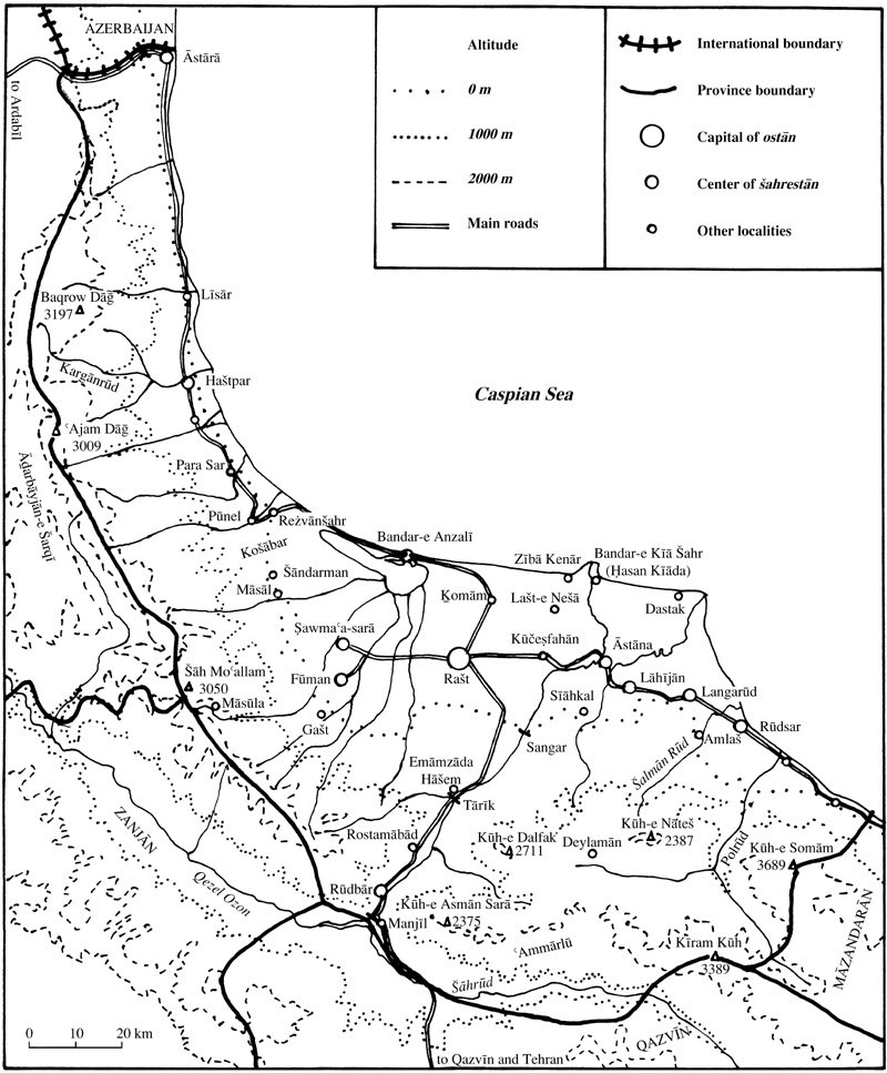
Administrative boundaries and divisions (Figure 2). In the late Qajar period (Rabino, 1915-16, pp. 57-58; tr. pp. 53-54), Gīlān was divided into nineteen districts; the larger districts, such as Mavāzī, which had recently united the four districts of Rašt, Kohdom, Kūčeṣfahān, and Ḵoškvejār, included several sub-districts (bolūks). Around 1950 (Razmārā, Farhang II), Gīlān was the main part of the so-called first province (ostān-e yakom), which included also two parts of the former Erāq-e ʿAjam (q.v.), the šahrestāns of Zanjān and Arāk, and was divided into five šahrestāns of Ṭavāleš, Fūman, Bandar-e Pahlavī (Anzalī), Rašt, and Lāhījān. In 1963 it was separated from Zanjān and Arāk and completed by the small šahrestān of Āstārā in the north, and thus took its present size and boundaries, with an area of 14,709 km2. It was divided into ten šahrestāns: Āstārā, Ṭavāleš, Ṣawmaʿa-sarā, Fūman, Bandar-e Pahlavī, Rašt, Rūdbār, Lāhījān, Langarūd, and Rūdsar. The only ulterior change in the administrative map was the accession of the baḵš of Āstāna, until then bound to Lāhījān, to the rank of šahrestān before the 1986 census. Population. Gīlān is the most densely populated province in Persia after the Tehran province, with 2,081,037 inhabitants in 1986 (141 inhabitants/km2) and has a marked ethnic personality. Its main ethnic groups belong all to the northwestern branch of the Iranian linguistic group (Bazin and Bromberger, pp. 13-14 and map 3). The most important one is the Gīlak, who live in the central plain, the eastern coastal fringe and the southeastern highlands. But both dialectal differences and socio-cultural features oblige to divide the Gīlak into three groups: the raštī and lāhījānī Gīlak, respectively in the western and the eastern part of the plain, show only slight differences, but the gālešī Gīlak or deylamī in the southwestern mountains have quite another language as well as an agropastoral way of life opposed to that of the Gīlak paddy-growers in the plain. On the western bank of the Safīdrūd, a similar contrast is to be seen between the Gīlak in the plain and the Ṭāleš whose area stretches from the piedmont to the ridge of the Alborz (q.v.). The tātī dialect is spoken around Rūdbār. Very few newcomers have settled more recently in the province: Kurdish buffalo herders scattered in the plain, the ʿAmmārlū Kurdish tribe that has given its name to the district east of Rūdbār, Turkish traders and fishermen along the coast from Āstārā to Anzalī, and Persian employees of the state administrations. Thus, multilinguism is the rule throughout the province (Bazin and Bromberger).
As for religious affiliation, the bulk of the population belongs to the Shiʿite Muslim majority of Persia. A part of the Ṭāleš make out a significant Sunnite (Shafiʿite) minority in central and northern Ṭāleš (Bazin, 1980).
Rural settlements and economic activities. The whole plain has a very high rural density, mostly between 100 and 300 inhabitants/km2, and a characteristic pattern of settlement: the basic housing, economic, and social unit is not the village as in interior Persia but the maḥalla, a loose grouping of houses surrounded with gardens and orchards. The houses themselves (Bromberger 1974 and 1986a) are made out of several buildings with specific architecture and functions: the family house, stable, hen-house, paddy-barn, silkworm-nursery, tobacco-drying room, etc. Traditional buildings consist in a wooden frame filled with a mixture of loam and straw and are crowned with a steep hipped roof covered with thatch, rushes, or shingles. They are gradually replaced by more plain “modern” buildings of cement blocks covered with tiles or sheet-iron.
The main agricultural crop is by far rice (Rabino and Lafont; Sahami, pp. 50-59; Eškevarī; Bazin, 1980, pp. 111-44). Nearly all the irrigable areas (more than 40 percent of the whole surface of the plain) are devoted to paddy fields. Traditional irrigation methods (channels derived from streams, springs, reservoirs) are still in use in western and eastern Gīlān, but have been replaced in the central Gīlān plain by a modern irrigation network using the water of the Safīdrūd. Stocked in the Manjīl reservoir dam, its water is then derived from the distribution dams of Tārīk and Sangar into the main distribution canals, the canal of Fūmanāt and the two canals of Sangar left bank and right bank, and thence to a full network of secondary and tertiary channels. Ploughing and raising borders is now mechanized through the use of Japan-made tillers, but transplanting seedlings, weeding, and harvesting remain manual operations, whereas traditional threshing and husking devices have been abandoned and replaced by threshing-machines and semi-industrial husking-plants. The greater part of the crop is commercialized towards the whole national Persian market.
If rice cultivation is omnipresent, it is generally complemented by other crops, mostly pluvial crops grown around the maḥalla or on higher grounds unfit for irrigation. The only microregions where paddy is almost exclusive are the head of the Safīdrūd delta, between Rašt and Lašt-e Nešā, and the Ṭāleš Dūlāb district in central Ṭāleš. Everywhere else, one or two other crops have a significant position, and their relative importance differentiates the plains into smaller specialized areas. Growing mulberry (tūt) trees in order to breed silkworms in long specialized buildings called telambār is the most ancient activity, once more important than paddy cultivation. After a long period of decline, silk production has seen some renewal, with two main areas confined along the piedmont fringe: in western Gīlān from the Ḵošābar valley to the Gašt valley, and in eastern Gīlān between Āstāna and Qāsemābād. Tea, though introduced later in Gīlān (in 1902, see ČĀY), is now the most important plantation crop, with its main areas around Lāhījān (Ehlers, 1970), where all the hills behind the piedmont have been turned into tea gardens, and in southern Fūmanāt. Tobacco is grown in lower (northwestern) Fūmanāt and central Ṭāleš, and fruit trees along the two coastal fringes, producing temperate fruit such as cherries and plums in northern Ṭāleš and citrus fruits (q.v.) in eastern Gīlān to the east of Kalāčāy.
Animal husbandry (Pour-Fickoui and Bazin) has a subordinate position all over the Gīlak maḥalla of the central plain, due to the lack of good pastureland. In the past almost every family used to own one or two cows to milk, an ox for ploughing, and a horse for transportation, but the last two have mostly been replaced by a small motor tiller. A few farmers have a significant number of cattle, which they send in summer to enclosed wet pastures (qoroq) on the bank of the Anzalī lagoon and smaller marshy areas, also used by specialized Kurdish buffalo-herders (Beyhaqī).
On the contrary, animal husbandry is one of the main income sources for the Ṭāleš and Gāleš inhabitants of the mountain belt. The Ṭāleš peasants living on the piedmont of the western range combine paddy-cultivation with pastoral life. In addition to the usual horse and cows, they own sheep and goats that spend the winter in nearby hills (qešlāq), and take all of them to one or several levels of summer pastures (yeylāq or gīrīa) in the mountain. The Ṭāleš range itself is sparsely populated; in central and northern Ṭāleš, the inhabitants of small hamlets on the lower slopes or more compact villages higher in the mountain grow some wheat and corn and raise cattle and sheep, whereas in southern Ṭāleš scattered families dwelling in wooden houses or huts live entirely upon their herds and flocks (Bazin, 1980, II, pp. 5-52).
In eastern Gīlān too, some inhabitants of the piedmont, such as citrus-growers of the easternmost districts, and most people in the interior raise cattle and sheep with various migration patterns between winter forest pastures and summer high mountain pastures. Wheat rainfed cultivation covers wide areas in the interior districts of Deylamān, ʿAmmārlū and Eškevarāt.
Thanks to its Mediterranean-like climate, the small area around Rūdbār and Manjīl has an agricultural system unique in Persia. Olive groves provide the main source of income, combined with wheat and animal husbandry, plus paddy fields along the Safīdrūd bed in the Rostamābād district downstream from Rūdbār.
Another activity specific to the Caspian, if not to Gīlān alone, is the sturgeon fisheries (šīlāt) along the coast (Carré; Rostami; Bazin, 1980, II, pp. 129-37; see also FISHERIES AND FISHING). They have always been a foreign body in the local economy: Initiated by the Russians, they were granted to a Russian firm under the Qājārs, then, from 1928-53, to an Irano-Soviet joint company and since 1953 to the state-owned Šerkat-e sehāmī-e šīlāt-e Īrān. Both the employees of the headquarters of the company in Ḡāzīān (eastern quarter of Anzalī) and the fishermen working in the small fisheries are mostly Azeri people, either from former Soviet Azarbaijan or from villages in the šahrestān of Ardabīl and Ḵalḵāl adjacent to Gīlān. The latter come to Gīlān twice a year, during winter and early spring, and in late summer between harvest and sowing. The sturgeons caught in all the small fishing-stations are gathered in Gāzīān, where caviar (q.v.) is prepared. Although the consumption of sturgeon, as a scaleless fish, is prohibited (ḥarām) by Islam, production has been kept on after the Islamic Revolution, and Gīlān provides approximately the half of the Persian production of caviar (between 200 and 250 tons yearly in the 1980s) and sturgeon fish (between 1400 and 1700 tons). In addition to this highly specialized activity, some 26 fishing cooperative societies, employing both Gīlānī and Azeri fishermen, catch ḥalāl (legally authorized) scale-fish (between 4,000 and 6,000 tons).
Industry, trade and urbanization. Gīlān is one of the least urbanized provinces of Persia with only 37.7 percent of its population living in towns in 1986, due to its very high density of rural population and its relatively low level of industrialization. Actually, Gīlān has no significant mineral resources, and the bulk of its industrial plants process agricultural products: rice husking mills all over the plain, tea factories in Fūmanāt and Lāhījān, oil factories around Rūdbār, fish and caviar processing plant in Anzalī, and silk winding off plant, tobacco factory, dairy products and beverages in Rašt. A huge complex was built in the mid-1970s to exploit another natural resource, the wood of the extensive forests of western Gīlān, the Čūkā(čūb “wood” and kāḡaz “paper”) company with a saw-mill in Ḵalīfa-ābād of Asālem and a paper-mill in Pūnel, in addition to smaller private saw-mills in southern Ṭāleš and eastern Gīlān (Bazin, 1980, p. 171). Besides this sector based on regional resources, the only noticeable industries are concentrated in Rašt.
Commercial activity is well developed with a very dense network of trading centers, much thicker than in interior Persia. Every maḥalla has its own grocer’s and coffee-shop, and above this basic level every small geographical unit has a bāzār, a commercial center with various shops and workshops and some services, often located along the main roads. But the most original feature of the plain of central Gīlān (as well as of central Māzandarān) is the number and flourishing activity of weekly markets (Thorpe), grouped in organized cycles (Kamioka). Urban centers associate a richer commercial structure, with several hundreds of shops and a beginning of functional segregation, and administrative activity as chief towns of šahrestān. Only two of them have a greater demographic and economic weight, Anzalī (q.v.) in the west and Lāhījān in the east, but stay far under the capital of the province Rašt, which dominates the urban life of Gīlān.
See also ABRĪŠAM; BERENJ; ČĀY.
For a music sample, see Prayer at the end of work.
For a music sample, see Kara Bašimuna Nana.
Bibliography
M. T. Achouri, La poterie artisanale au Gilân, Aix-en-Provence, 1977.
A. H. Adle, Āb o hawā-ye Īrān/Climats de l’Iran, Tehran, 1339 Š./1960 (Persian and French abstract).
M. Alimardani, “Les sols du piémont nord de l’Alborz et du littoral caspien (Iran),” Méditerranée 22, 1975, pp. 69-77.
E. Amin-Sobhani, “Contribution à l’étude sédimentologique et géochimique des plaines sud de la mer Caspienne,” Ph.D. thesis, University of Paris, 1972.
R. N. Annells et al, Explanatory Text of the Qazvin and Rasht Quadrangles Map 1/250,000, Tehran, 1975.
Association Française du Génie Parasismique, Le séisme de Menjil (Iran) du 20 juin 1990, Paris, 1990.
M. ʿAṭāʾī, “Gozāreš-e eqteṣādī dar bāra-ye berenj-e Gīlān wa sāyer-e ḡallāt-e ān/Economic Report on Rice and Other Cereals in Gilan,” Taḥqīqāt-e eqteṣādī 2/5-6, 1342 Š., pp. 64-148 (Pers. ed.), 1963, pp. 32-53 (Eng. ed.).
M. Bazin, Le Tâlech, une région ethnique au nord de l’Iran, 2 vols., Paris, 1980; tr. M. Amīn Farščīān as Ṭāleš, manṭaqa-ī qawmī dar šemāl-e Īrān, Mašhad, 1367 Š./1988.
Idem, “La culture du tabac dans le Gilân,” Stud. Ir. 9/1, 1980, pp. 121-30.
Idem, “Ethnies et groupes socio-professionnels dans le nord de l’Iran,” in J.-P. Digard, ed., Le fait ethnique en Iran et en Afghanistan, Paris, 1988, pp. 77-88.
Idem, “Identité ethnique et identité régionale en Iran,” in P. Claval and Singaravelou, ed., Ethnogéographies, Paris, 1995, pp. 157-72.
Idem, “Le Tâleš revisité,” St. Ir. 25/1, 1996, pp. 115-34.
M. Bazin and C. Bromberger, Gilân et Ãzarbâyjân oriental. Cartes et documents ethnographiques, Paris, 1982; tr. M. Amīn Farščīān as Gīlān wa Āḏarbāyjān-e šarqī. Naqšahā wa asnād-e mardom-šenāsī, Tehran, 1365 Š./1987.
F. Bémont, Les villes de l’Iran, 2 vols., Paris, 1969, I, pp. 234-43; II, pp. 215-23.
Ḥ.-ʿA. Beyhaqī, “Gāvmīš-dārī dar rūstā-ye Lāča-gūrāb,” in M.-Ḥ. Pāpolī Yazdī, ed., Majmūʿa-ye maqālāt-e semīnār-e joḡrāfī, Mašhad, 1365 Š./1986, III, pp. 357-76.
H. Bobek, Die natürlichen Wälder und Geholzfluren Irans, Bonn, 1951.
C. Bromberger, “Habitations du Gilân,” Objets et Mondes 14/1, 1974, pp. 3-56.
Idem, Habitat, architecture et société rurale dans la plaine de Gilân (Iran septentrional), Paris, n.d. (1986a); tr. as Habitat, Architecture and Rural Society in the Gilân Plain (Northern Iran), Bonn, 1989.
Idem, “Les blagues ethniques dans le nord de l’Iran. Sens et fonctions d’un corpus de récits facétieux,” Cahiers de littérature orale 20, 1986, pp. 74-101.
Idem, “Comment peut-on être Rašti? Contenus, perceptions et implications du fait ethnique dans le nord de l’Iran,” in J.-P. Digard, ed., Le fait ethnique en Iran et en Afghanistan, Paris, 1988, pp. 89-107.
Idem, “Eating Habits and Cultural Boundaries in Northern Iran,” in S. Zubaida and R. Tapper, eds., Culinary Cultures of the Middle East, London, 1994, pp. 185-201.
F. Carré, “Les pêches en mer Caspienne,” Annales de Géographie 479, 1978, pp. 1-39.
G. C. Clarke et al., Explanatory Text of the Bandar-e Pahlavi Quadrangle Map 1/250,000, Tehran, 1975.
Dānešgāh-e Tehrān, Moʿassasa-ye joḡrāfīā, Aṭlas-e eqlīmī-e Īrān, Tehran, 1344 Š./1965.
C. Djavadi, Climats de l’Iran, Paris, 1966.
E. Ehlers, “Die Teelandschaft von Lahidjan/Nordiran,” in Beiträge zur Geographie der Tropen and Subtropen. Festschrift für Herbert Wilhelmy, Tübingen, 1970, pp. 229-42.
Idem, Südkaspisches Tiefland (Nordiran) und Kaspisches Meer, Tübingen, 1971a.
Idem, “Nordpersische Agrarlandschaften. Landnutzung und Sozialstruktur in Ghilan und Mazanderan,” Geographische Rundschau 13/9, 1971b, pp. 329-42.
Idem, “Die Städte des südkaspischen Küstentieflandes,” Die Erde 102/1, 1971c, pp. 6-33.
Idem, “Die südkaspische Stadt-Typus oder individuum?” ibid., 103/2, 1972, pp. 186-90.
Idem, Iran: Grundzüge einer geographischen Landeskunde, Darmstadt, 1980.
K. S. Eškevarī, “Goḏar-ī dar šālīzārhā-ye Gīlān,” Honar o mardom, N.S. 117, 1351 Š./1972, pp. 39-45.
E. Faḵrāʾī, Gīlān dar goḏargāh-e zamān, Tehran, 1354 Š./1975.
F. Farīd-e Pāk, Āb o hawā-ye karāna-ye šemālī-e Īrān, Bandar-e Pahlavī (Anzalī), 1325 Š./1946.
W. Frey and W. Probst, “Vegetation und Klima des Zentralelburz und der südkaspischen Küstenebene (Nordiran),” in E. Ehlers, ed., Beiträge zur physischen Geographie Irans, Marburg on the Lahn, 1974, pp. 93-116.
M. H. Ganji, “The Climates of Iran,” Bulletin de la Société de géographie d’Egypte 28, 1955, pp. 195-299.
Gītā-šenāsī, Naqša-ye Jomhūrī-e Eslāmī-e Īrān, Tehran, n.d. (ca. 1995).
A. Kadīvar, Tārīḵ-e Gīlān, Tehran, 1319 Š./1940.
K. Kamioka, “The Networks of Weekly Markets and Bazarmajs in Gilan,” in The Bazaar in the Culture and Civilization of the World of Islam, Tabrīz, 1993.
M. Kayhān, Joḡrāfīā-ye mofaṣṣal-e Īrān, 3 vols., Tehran, 1310-11/1931-32.
K. Kešāvarz, Gīlān, Tehran, 1347 Š./1968.
Kh. Khosrovi, “Les marchés hebdomadaires paysans en Iran,” Études rurales 67, 1977, pp. 85-91.
M. M. Lāhījānī, Joḡrāfīā-ye Gīlān, Najaf, 1389/1969.
Markaz-e āmar-e Īrān, Farhang-e ābādīhā-ye kešvar: Ostān-e Gīlān, Tehran, 1348 Š./1969.
X. Misonne, Analyse zoogéographique des mammifères de l’Iran, Brussels, 1959.
S. Mobayen and V. Tregubov, Guide pour la carte de la végétation naturelle de l’Iran au 1/2 500 000, Tehran, 1970.
L. Mofakham Payan, Les principales rivières de la région du Guilân, Mašhad, 1347 Š./1969 (actual date 1331 Š./1952).
A. Mossadegh, “Aperçu général sur les hêtraies montagnardes des forêts de la Caspienne en Iran,” Revue forestière française, 1968, 1, pp. 20-27.
Idem, “Contribution à l’étude des types forestiers de la forêt hyrcanienne en Iran,” Journal forestier suisse 123/8, 1972, pp. 527-32.
A. Noirfalise and M. H. Djazirei, “Contribution à la phytogéographie de la forêt caspienne,” Bulletin de la Société royale de botanique de Belgique 98, 1965, pp. 197-214.
A. Pour-Fickoui, “L’habitat pastoral au Gilân,” Luqmān 1, 1985-86, pp. 49-60.
A. Pour-Fickoui and M. Bazin, Elevage et vie pastorale dans le Guilân (Iran septentrional), Paris, 1978.
H. L. Rabino, Carte de la province du Guîlân, Lyon, 1914.
Idem, Les provinces caspiennes de la Perse: Le Guîlân, RMM 32 (1915-16), Paris, 1917; tr. J. Ḵomāmīzāda as Welāyāt-e dār al-marz-e Īrān: Gīlān, Tehran,1357 Š./1978.
Idem, Les provinces caspiennes de la Perse. Le Guilân: Illustrations, Paris, 1917.
H. L. Rabino and D.F. Lafont, “La culture du riz en Guilân,” Annales de l’Ecole d’Agriculture de Montpellier 10, 1910, pp. 130-64; 11, 1911, pp. 5-51.
Research Group, “A Study of Rural Economic Problems of Gilan and Mazandaran,” Taḥqīqāt-e eqteṣādī 4/11-12, English ed., 1967, pp. 135-204.
I. Rostami, Biologie et exploitation des esturgeons (Acipenséridés) Caspiens, Bar-le-Duc, 1961.
C. Sahami, L’économie rurale et la vie paysanne dans la province sud-caspienne de l’Iran, le Guilân, Clermont-Ferrand, 1965.
Idem, “Naẓar-ī be manābeʿ-e āb wa taḥawwolāt-e jadīd dar neẓām-e ābyārī-e dašt-e Gīlān,” MDAM 8/1, 1351 Š./1972, pp. 1-32.
E. Schütz, Die Vogelwelt des Süd-Kaspischen Tieflandes, Stuttgart, 1959.
SOGREAH-COTHA, Réseau du barrage du Sefidroud, mise en valeur de la plaine du Guilân, Tehran, Report to the Plan Organization, 1342 Š./1963.
M. Sotūda, Az Āstāra tā Estārbād I, Tehran, 1349 Š./1970.
B. Spuler, “Gīlān,” in EI2 II, pp. 1111-12.
J. Stöcklin, “Structural History and Tectonics of Iran: A Review,” American Association of Petroleum Geologists Bulletin 52, 1968, pp. 1229-58.
Ḥ. Ṯābetī, Deraḵtān-e jangalī-e Īrān, Tehran, 1326 Š./1947.
Idem, Jangalhā-ye Īrān, Tehran, 1346 Š./1967.
J. D. Tholozan, “Sur les vents du nord de la Perse et sur le foehn du Guilân,” Comptes rendus de l’Académie des sciences, no. 100, 1885, pp. 607-11.
J. K. Thorpe, “Cyclic Markets and Central Place Systems. The Changing Temporal and Locational Spacing of Markets in the Caspian Littoral of Iran,” in E. Ehlers, ed., Beiträge zur Kulturgeographie des islamischen Orients, Marburg on the Lahn, 1979, pp. 83-110.
University of Strathclyde, Department of Urban and Regional Planning, Iran. Gilan Regional Study, Glasgow, 1977.
P. Vieille, Le groupement féodal en Iran: Example d’un groupement au Guilân, Tehran, 1963.
Idem, “Les paysans, la petite bourgeoisie rurale et l’Etat après la réforme agraire en Iran,” Annales: Economies, Sociétés, Civilisations 27, 1972, pp. 347-72.
O. L. Vil’chevskiĭ, “Giliyaki i galeshi, talyshi” (Gīlak, Gāleš, and Ṭāleš), in N. A. Kislyakova and A. U. Persica, ed., Narody Peredneĭ Azii (Peoples of Anterior Asia), Moscow, 1957, pp. 225-41.
Wezārat-e kešvar. Edāra-ye koll-e āmār wa ṯabt-e aḥwāl, Ketāb-e asāmī-e dehāt-e kešvar, 3 vols., Tehran, 1329-31 Š./1950-52, I, pp. 74-151.
E. Wirth, “Zum Problem des Bazars und Umlandbeziehungen iranischer Städte,” Die Erde 103/2, 1972, pp. 184-86.
M. Zohary, “On the Geobotanical Structure of Iran,” Bulletin of the Research Council of Israel, section D, 11 D, suppl., 1963.