


Geography
iii. POLITICAL GEOGRAPHY
The significant Persian-speaking areas of the world are divided today into three states. One of them, Tajikistan, is very recent. It corresponds with the part of the Iranian world that was annexed as a result of the Russian colonial expansion in Central Asia in the late 19th century and which, set up as a Soviet Socialist Republic in 1929, became an independent state after the demise of the USSR in 1991. The other two, Persia and Afghanistan, are much more ancient structures, with a centuries-old evolution behind them.
TAJIKISTAN
The territory of Tajikistan corresponds with the predominantly Iranian ethnic sector of the mountainous south-eastern periphery of the Bukhara emirate, which came under Russian influence at the end of the 19th century. Its southern and eastern borders with Afghanistan and China are the results of international treaties concluded by Russia with China and Great Britain at the time (see BOUNDARIES; Prescott, 1975). Its northern and western borders with Uzbekistan and Kirgizistan go back to the division carried out by the Soviet authority within the framework of its policy of nationalities after the First World War. Tajikistan was created on 14 October 1924 as an autonomous republic within Uzbekistan. At the time it essentially consisted of the mountainous region of the Alai and the Pamirs, with its southwestern foothills towards the Amu Darya, bordering on Afghanistan. The founding in 1925 of the new city of Dushanbe (Stalinabad), chosen as the capital of this young republic south of the Alai, oriented the latter towards the Amu Darya and the south. But the raising of Tajikistan to the full rank of a Soviet Socialist Republic on 16 October 1929 involved a crucial event: on the basis of ethnic criteria, the part of the Fergana basin which presented a Tajik majority was joined to it. This was the Khojend/Khodzhent oblast (Leninabad from 1936 to 1991), with 56 percent Tajiks against 31 percent Uzbeks and 7 percent Kirghiz in the 1920 census. It led to the incorporation within this new republic, which had so far been almost exclusively mountainous and poor, of a fraction of the densely populated and rich cotton-growing region (30 percent of the population of Tajikistan in 1989, for 18 percent of the surface). This allocation, which subsists even today after independence, has created grave problems of internal liaison and national construction. The link of the southern part of the country with the Fergana indeed only consists of a narrow corridor, 32 km wide, across the western end of the Alai, with 3,300 m high passes that are closed six months a year. As for a railway connection, it could only be realized at the price of a tortuous detour via Termez (Uzbekistan), Karki (Turkmenistan) and Samarkand (Uzbekistan), with four frontier crossings (Balland, 1997, p. 96). A similar problem arises for the high Zarafšān valley, which only opens out into Samarkand. In comparison, the difficulties created by two little Tajik enclaves within Kirghiz territory, and a Tajik enclave in Uzbek territory, appear insignificant.
Similarly, the 1929 division had, for obscure reasons, attached the Sokh region (325 km2) on the northern slope of the Alai, to Uzbekistan. Today it is an Uzbek enclave in Kirghiz territory, but it had been part of Tajikistan between 1924 and 1929, and 99 percent of its population are Tajiks (Balland, 1997, pp. 97-98). These absurdities show that the “ethnic” layout carried out in 1929 on Stalin’s instructions was far from ideal. It nevertheless provided the Tajiks with a leading place in their republic, where they formed 62 percent of the population in 1989, as against the Uzbeks (23.5 percent) and Russians, while 75 percent of the Tajiks in what used to be Soviet Central Asia live in Tajikistan, as against 22 percent in neighboring Uzbekistan (Balland, 1997, pp. 110-11).
PERSIA
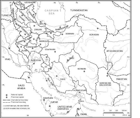
Figure 1. Boundaries and provincial administrative divisions of the Islamic Republic of Iran (1995). After United Nations Department of Public Information, Cartographic Section, map no. 3891.
The major political structure which today corresponds with the western part of the Iranian world can be traced back more or less continuously for over two and a half millennia. The Iranian plateau, however, with its vast stretches of desert occupying the center and the south-east, hardly lent itself to an efficient centralization, and the power centers, as well as their spheres of influence, have greatly varied over the years. A lasting stabilization of the Persian state within its actual outlines was not an easy task. Persia’s dynamic quality caused it to go far beyond its theoretical ethnic limits in antiquity. And the later Turko-Mongol invasions brought about a formidable interlinking of populations in the course of the last thousand years. All these factors could have led to very different geographic structures, as shown by the historical succession of territorial divisions (Naṣr, Mostawfī, and Zaryāb). The present Persian state in fact expresses the supremacy of neo-Persian culture and its appeal to the Turkish invaders who for a long time dominated it politically (Planhol, 1993, pp. 479-94).
It must have been southwest and west of the desert, in the rainwater cultivation areas of the Zagros and Azarbaijan, that the first concentration of people led to the emergence of a political power. Here the Median empire was founded, followed by that of the Achaemenians, who soon ventured beyond the Iranian borders to occupy all the countries of the eastern Mediterranean. The Mesopotamian basin with its rich irrigated soil thus became an Iranian power base under the Seleucids, the Sassanids, and even, in the interval, the Parthians (who originally came from Khorasan), until the Arab conquest and the process of Islamization made Persia lose its individuality for several centuries. The Abbasid reaction merely managed to move the seat of the caliphate to Baghdad and not to the Persian plateau. Once it weakened, it was on the contrary east of the central deserts, and especially in Khorasan, where there reappeared power centers away from the caliphate. Meanwhile, theoretical bonds of vassalage were still attached to the caliph on behalf of the Tahirids, Saffarids, Samanids, and Ziyarids, who only wielded a modest influence west of the plateau. In the 10th-11th centuries, the Buyids occupied Baghdad and took the caliphate under their control. Thus, for almost a century, just before the Turkish conquest, they re-established a central Iranian state on the western part of the plateau, dominating Mesopotamia. However, Persia again lost all political significance within the vast Turkish empires of the Ghaznavids and Seljuks, although the capital of the latter was temporarily established in Isfahan.
After the Shahs of Ḵᵛārazm had for several decades (late 11th to early 12th centuries) reconstructed a vast eastern Iran with its center in Khorasan and Transoxiana, the Mongol conquest occurred. Following the partition of the empire of Čengīz Khan (q.v.) and the establishment of an independent branch (the Ilkhanids) on the Iranian plateau, with their capital in Solṭānīya, a vast empire was again created, stretching beyond the Iranian borders from the Oxus to the Indus and down to Mesopotamia and the heart of Asia Minor. Split into a multitude of principalities in the late 14th century, this empire was temporarily reconstructed by Tīmūr, but his son Šāhroḵ and his later successors shifted the center of their empire to Khorasan and Transoxiana, and later to Herat. In the chaos of the Turkoman principalities (Aq Qoyunlu, Qara Qoyunlu) who occupied western Persia in the 15th century, several permutations became possible in the political geography of the region.
The present political structure of Persia goes back to the Safavids, who, in the 16th century, cemented its unity by establishing Shiʿism as the state religion and stabilizing the Turkish ascendancy in Azarbaijan by regrouping the Shiʿite Turkish tribes from Anatolia (see above). Persia thus remained under a Turkish dynasty, integrating within its own culture those elements that had chosen to confront the Sunni powers of the Ottomans and Uzbeks. Spiritual unity was being forged through pilgrimages to the great religious centers (Qom, Mašhad, Ardabīl), in an atmosphere of popular piety (Planhol, 1993, pp. 505-509). The power center from then on did not move away from a median line of the plateau (Isfahan, Shiraz, Tehran), whence it was possible to face various threats. Details of the country’s frontiers were to be gradually defined in the course of the military fights of the following centuries (see BOUNDARIES), but the overall principle of its structure remained unchanged.
This structure, however, remains very complex. Persia is a mosaic of ethnic and religious affiliations. It includes, on the one hand, the central Shiʿite nucleus formed by the association of Turkish-speaking Azaris (about 20 percent of the population) and ethnic Persians of the central plateau, Khorasan, and Fārs (Planhol, 1993, pp. 509-24); and on the other, the peripheral areas which have proved slow to integrate and unreliable. These include the mountainous fringe of the Caspian, which, for a long time, had no adequate links with the plateau (the first roads suitable for vehicles date from the reign of Nāṣer-al-Dīn Shah). Besides, its adoption of Persian culture remains very imperfect even today, since it has preserved its linguistic and material idiosyncrasies, whereby non-Persian Iranian languages are still spoken by about 12 percent of the total population (Planhol, 1993, pp. 524-36) and a Sunni affiliation subsists in the Ṭāleš (Bazin, 1980, pp. 198-200, pp. 524-36). There are the large nomadic confederations of the Zagros (see above), who are Shiʿite but insubordinate (Planhol, 1993, pp. 542-46); the Kurds of the western Zagros (5 percent of the country’s population); the Turkmen of the Atrak steppes (several hundreds of thousands of people); the Baluch of the south-east (2-3 percent of the total population); the Arabs of the southern coasts and Ḵūzestān; the four latter groups are all Sunni and not well integrated (Planhol, 1993, pp. 546-55). The mere political submission of these peripheral elements was obtained very late, and it was not until the 1930s that Reżā Shah restrained the insubordination of the Turkmen and the Baluch, which started up again after the Islamic Revolution.
The administrative control over this area has been very chaotic in the last century, with a constant re-organization of the provincial divisions (Hourcade et al., p. 25), since the network was far too weak all over the center and the south-east. This conveys both the barren character of the geographic milieu and the low density of the population, but also a certain weakness on behalf of the political power. The main centralizing factor today is the metropolitan polarization which has made much progress over the last fifty years. In the 1950s, Tehran’s sphere of influence (maps in Planhol, 1964a, p. 74) only extended over the northwest of the country and the heart of the plateau up to the limits of the Zagros, which was still entirely polarized towards the Gulf cities, particularly Ābādān (q.v.). It was only from the 1960s and 1970s on that the influence of the capital extended over the Zagros, including Kurdistan and Fārs. Today Mašhad alone is a truly autonomous center of influence, especially for the regions situated east and southeast of the great desert, although the direct attraction of Tehran is already being felt as far as Baluchistan. The growth in influence of the other regional capitals (Tabrīz, Isfahan, Shiraz, etc.) is not negligible,but they are, however, completely engulfed within Tehran’s catchment area (maps in Hourcade et al., pp. 52-53).
AFGHANISTAN
Figure 2. The formation of the Afghan state. (a) Territorial divisions of the Pashtuns. (b) Borders of the Afghan state 1762-72 and its international boundaries today. After Planhol, 1993, p. 608, fig. 46.
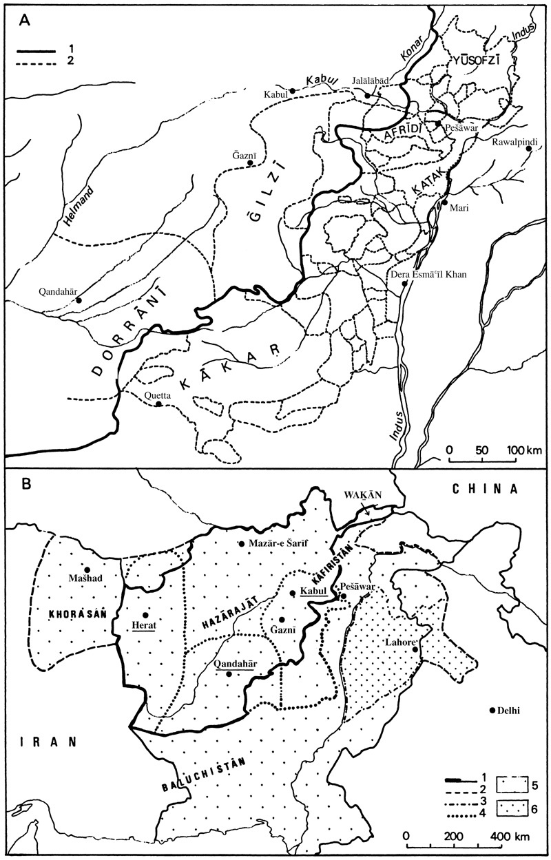
Figure 3. Evolution of administrative divisions of Afghanistan. (a) Divisions in 1946. (b) Divisions to 1964. (c) Divisions after 1964. (d) Divisions in 1982. After Planhol, 1993, p. 630, fig. 47.
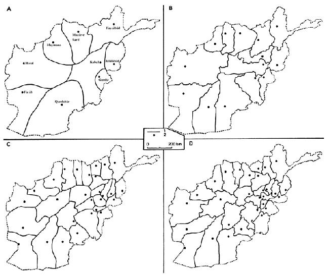
Although political organizations were several times established east of the great deserts of central and eastern Iran, both before and after the Turko-Mongol invasions (the Ghaznavids with their center in Ghazni, the shahs of Ḵᵛārazm, the Timurids of Herat), it is by no means in these structures of an imperial type and without any particular ethnic background that we must seek the origins of present Afghanistan. The latter indeed expresses the dynamism belonging to a well-defined people, the Pashtus or Afghans, whose ethnic origins no doubt go back to the first centuries of our era. This was when the Sakas, relatives of the Parthians and speaking a northeastern Iranian language, arrived in Sīstān, which has preserved their name, and the Indus basin, assimilating the earlier populations who spoke south-eastern Iranian languages, of which some traces survive (Ōrmuṛī and Parāčī). The name of the Afghans has since appeared as such in 3rd and 4th century Sasanian inscriptions (Caroe, pp. 79-80), and they continued being aware of their individuality although it certainly incorporated numerous Turkish elements. Their center was no doubt the Solaymān mountains to begin with, where they practiced a short-distance semi-nomadism. They spread all over what is now central Afghanistan due to the disorders provoked by the great medieval invasions. Living in a political vacuum away from the urban centers of the Indus basin and the Iranian plateau, these populations used their factual independence to cement their identity around a profoundly original system of values (paštūnwalī), organized into a coherent whole (Spain, 1962; 1963, pp. 63-69; Barth, 1969; Kieffer, 1972; Janata and Hassan, 1975; Ahmed, 1980; Steul, 1981). It involved no external influence and formed the foundation of an exemplary social cohesion underlying the secret of their successful expansion (Planhol, 1993, pp. 604-17).
Its starting-point in the 16th and 17th centuries, in the political no-man’s-land formed by the present territory of Afghanistan among the major powers of the Uzbeks of lower Central Asia, the Great Moghals of India, and the Safavids of Persia, was the failure of the latter, who would have been best qualified to submit and incorporate this country (ibid, pp. 617-18). The birth of Afghanistan was a manifestation of this incapacity. The rebellion of the Ḡilzī (q.v.) who pillaged Isfahan in 1722 and ruled Persia until 1730, when they were ousted by Nāder Shah, is the first sign of the emergence of Pashtu power. This was formally manifested in 1747 by an independent political entity when Aḥmad Shah, the head of the Dorrānī, had himself crowned sovereign of all the Afghans in Qandahār. This first Afghan state, which briefly extended from the Amu Darya to the Indus basin and the sea of Oman, was a prefiguration of present Afghanistan. It was actually shifted southward, but was already marked by an early northward expansion of the Pashtu tribes into the Herat region and the Bādḡīs, where the barrier of the central mountains grows lower (Planhol, 1973, pp. 8-10). Tīmūr (1772-93) had already shifted his capital to Kabul, which was better placed to control the routes to India and the northwest. But after the disintegration of this first construction in the internecine fights, the Afghan influence under Dost Moḥammad (1836-63) in the mid 19th century was strictly confined to the south of the Hindu Kush barrier, and the Hazārajāt were completely outside its reach.
The birth of the second Afghan state, and of the country in its present configuration, is the result of external circumstances, namely the struggle between the two great colonial powers, Russia and Great Britain. After two fruitless attempts, in 1839-42 and 1878-80, to bring the country under its zone of influence, Great Britain decided to turn Afghanistan into a buffer state centered on the Hindu Kush and destined to block the way to India against the Russians who were in dangerous proximity. This new concept was firmly established in 1881 by the Liberal government of Gladstone. The Hindu Kush barrier was to become the axis and raison d’être of the new state.
There remained the task to build up this state, and first of all to determine its boundaries, which was not easy (see BOUNDARIES iii; Planhol, 1993, pp. 621-23). The control of the internal space was essentially the accomplishment of ʿAbd-al-Raḥmān (r. 1880-1901), the true creator of modern Afghanistan, who lent real substance to this theoretical geographic framework. He subdued the Uzbek emirates north of the Hindu Kush (last of all Maymana in 1884), and those of the Hazārajāt in 1891-93, and saw to the conversion of the Kafirs in 1895-96. While the latter could preserve their ethnic individuality in their mountains which defied all external penetration, this was not true of the rest of the country. Here political unification led to a considerable expansion of the Pashtu tribes, the instrument and spearhead of the central power. Thus the Hazārajāt massively opened up to their summer migration, and this new “bedouinization” actively developed until the mid-20th century. Its aspects were not exclusively negative. The Pashtu nomads were not only shepherds, but also merchants and caravan drivers, so they introduced market economy into these highlands, setting up gigantic temporary bazaars in the summer at an altitude of about 2,600-2,800 meters (Peter of Greece, 1954; Ferdinand, 1962, 1969). The other side of the coin was a growing debt of the Hazāra, who purchased consumer goods brought to them by the nomads, so that the latter were able to appropriate a large part of the region’s landed property and stabilize their presence there.
On the northern slope of the Hindu Kush, a Pashtu settlement was systematically organized after 1885 by settling the nomadic tribes in the northwest, on the Turkoman frontier (Tapper, 1983), and subsequently, under Ḥabīb-Allāh (r. 1901-19; q.v.), by settling them further east, in the Qaṭaḡan and as far as Badaḵšān. Some time later, peasants were attributed plots of land in the new irrigable areas (Grötzbach, 1972, pp. 94-96). Meanwhile there also arrived, from the southern slope, all sorts of different elements (Baluchis, Mongols), who repopulated ancient Bactria with a mixture of different elements (Collin-Delavaud, 1958, 1960; Planhol, 1973, 1976).
Political unification thus merely complicated the extraordinary cultural heterogeneity which defied any precise evaluation. So on the eve of the 1978 revolution and the ensuing disturbances and wars, various estimations attributed 40 to 55 percent of the population to the ethnically dominant Pashtus, against 35 to 45 percent to ethnic groups speaking Persian dialects and 10 to 15 percent to Turkish-speaking groups (four-fifths of them Uzbeks), without counting accessory elements (Baluchis, etc.). The facts are complicated by the frequent changes in ethnic identity (Balland, 1988). The cohesion of this disparate mixture was still weak on the eve of the 1978 revolution and the ensuing events. However, the administrative ascendancy had steadily developed. The number of provinces, starting with 6 at the beginning of the 20th century, had risen to 14 in 1964, then suddenly doubled to 28 in the same year. At the same time, a multiplicity of new towns and villages appeared, leading to an urban network which today encompasses the entire periphery of the central mountainous axis, except for the latter itself (Grötzbach, 1979, map 32).
The inauguration in 1964 of a road over the Salang pass, with a tunnel at an altitude of 3,337 m, for the first time opened a permanent winter route through the mountain and established a crucial link with the northern provinces. But metropolitan functions were still very inadequately carried out by Kabul (Planhol, 1993, pp. 661-70), since its demographic influence almost exclusively extended over the southeast of the country (map, ibid, p. 669). It thus appeared more like a cultural contest between the dominant Persian culture and a Pashtun political power than like a factor of national cohesion. Although in the course of the subsequent civil wars the problem of the country’s unity was at no time officially questioned, it cannot be safely said that the political construction thus realized is definitely viable.
Bibliography
A. S. Ahmed, Pakhtun Economy and Society, London, 1980.
T. J. Arne, “La steppe turcomane et ses antiquités,” in Hyllningsskrift tillägnad Sven Hedin, Stockholm, 1935, pp. 28-43.
E. E. Bacon, “An Inquiry into the History of the Hazara Mongols of Afghanistan,” Southwestern Journal of Anthropology, 1951, pp. 230-47.
D. Balland, “Le changement d’identité ethnique chez les nomades d’Afghanistan,” in J-P. Digard, ed., Le fait ethnique en Iran et en Afghanistan, Paris, 1988, pp. 139-45.
Idem, “Tents, Yurts, Huts, and Caves: On the Cultural Geography of Temporary Dwellings in Afghanistan,” Folk 33, 1991, pp. 107-15.
Idem, “Diviser l’indivisible: les frontières introuvables des états centrasiatiques,” Hérodote 84, 1997, pp. 77-123.
F. Barth, “The Land Use Pattern of Migratory Tribes of South Persia,” Norsk Geografisk Tidsskrift 17, 1959-60, pp. 1-11.
Idem, Nomads of South Persia, Oslo, 1964. Idem, “Pathan Identity and Its Maintenance,” in F. Barth, ed., Ethnic Groups and Boundaries: The Social Organization of Cultural Difference, Oslo, 1969, pp. 117-34.
M. Bazin, Le Tâlech: une région ethnique du nord de l’Iran, 2 vols., Paris, 1980.
H. Bobek, “Die Verbreitung des Regenfeldbaues in Iran” in Festschrift für Johann Sölch, Vienna, 1951, pp. 9-30.
O. Caroe, The Pathans 550 B. C.-A. D. 1957, London, 1958.
C. Collin-Delavaud, “Deux exemples de mise en valeur dans l’Afghanistan septentrional,” Bulletin de l’Association de géographes français 273-74, 1958, pp. 38-48.
Idem, “Khoadja Qendu: mise en valeur d’un piémont dans le Turkestan afghan, province de Maïmana,” Annales de Géographie, 1960, pp. 135-56.
J-P. Digard, Techniques des nomades baxtyâri d’Iran, Cambridge and Paris, 1981. R. Dor, “Nouvel exil pour les Kirghiz,” Afghanistan Journal, 1979, pp. 24-27.
G. K. Dulling, The Hazaragi Dialect of Afghan Persian: A Preliminary Study, Central Asian Monographs 1, London, 1973.
E. Ehlers, Iran: Grundzüge einer geographischen Landeskunde, Wissenschaftliche Länderkunden 18, Darmstadt, Germany, 1980.
D. Ehmann, Bahtiyāren-Persische Bergnomaden im Wandel der Zeit, Beihefte zum Tübinger Atlas des Vorderen Orients, Reihe B, Geisteswissenschaften 15, Wiesbaden, 1975.
C. G. Feilberg, La Tente Noire, Nationalmuseets Skrifter, Etnografisk Roekke 2, Copenhagen, 1944.
Idem, Les Papis, Nationalmuseets Skrifter, Etnografisk Roekke 4, Copenhagen, 1952.
K. Ferdinand, “The Baluchistan Barrel-Vaulted Tent and its Affinities,” Folk 1, 1959a, pp. 27-50.
Idem, Preliminary Notes on Hazâra Culture (The Danish Scientific Mission to Afghanistan 1953-55), Historisk-filosofiske Meddelelser udgivet af Det Kongelige Danske Videnskabernes Selskab 37/ 5, Copenhagen, 1959b.
Idem, “Nomad expansion and commerce in Central Afghanistan,” Folk 4, 1962, pp. 123-59.
Idem, “Ethnographical Notes on Chahâr Aymâq, Hazâra, and Moghol,” Acta Orientalia 28, Copenhagen, 1964, pp. 175-203.
Idem, “Ost-Afghanischer Nomadismus – ein Beitrag zur Anpassungsfähigkeit der Nomaden,” in W. Kraus, eds., Nomadismus als Entwicklungsproblem, Bielefeld, 1969, pp. 107-30.
A. Foucher, “La vieille route de l’Inde de Bactres à Taxila, MDAFA 1, 2 vols., Paris, 1942-47.
R. N. Frye, “Remarks on Baluchi History,” Central Asiatic Journal 6, 1961, pp. 44-50.
A. Gabriel, Die Erforschung Persiens, Vienna, 1952.
H. Goblot, Les Qanats. une technique d’acquisition de l’eau, Paris, The Hague, and New York, 1979.
E. Grötzbach, Kulturgeographischer Wandel in Nordost-Afghanistan seit dem 19 Jahrhundert, Afghanische Studie, 4, Meisenheim-am-Glan, 1972.
Idem, Städte und Basare in Afghanistan. Eine Stadtgeographische Untersuchung, Beihefte zum Tübinger Atlas des Vorderen Orients, Reihe B, Geisteswissenschaften 16, Wiesbaden, 1979.
E. Herzfeld, “Eine Reise durch Luristan, Arabistan und Fars,” Petermanns Mitteilungen 53, 1916, pp. 49-63, 73-90.
B. Hourcade et al., Atlas d’Iran, Montpellier and Paris, 1998.
A. Janata, “Die Bevölkerung von Ghor. Beitrag zur Ethnographie und Ethnogenese der Chahar Aimaq,” Archiv für Völkerkunde 17-18, 1962-63, pp. 73-136.
A. Janata and R. Hassas, “Ghairatman—Der gute Pashtune,” Afghanistan Journal, 1975, pp. 83-97.
Ch. M. Kieffer, “Über das Volk der Păṣtunen und seine Păṣtunwali, Beitrag zur afghanischen Ethnologie” Mitteilungen des Instituts für Orientforschung 17, 1972, pp. 614-24.
G. Kortum, “Zur Bildung und Entwicklung des Qašqāī-Stammes ‘Amale im 20 Jahrhundert” in G. Schweizer, ed., Interdisziplinäre Iran-Forschung: Beiträge aus Kulturgeographie, Ethnologie, Soziologie und Neuerer Geschichte, Beihefte zum Tübinger Atlas des Vorderen Orients B 40, Wiesbaden, 1979, pp. 71-100.
F. Kussmaul, “Siedlung und Gehöft bei den Tağiken in den Bergländern Afghanistans,” Anthropos 60, 1965a, pp. 487-532.
Idem, “Badaxšan und seine Tağiken,” Tribus 14, 1965b, pp. 11-99.
G. Melgunof, Das südliche Ufer des Kaspischen Meeres oder die Nord-provinzen Persiens, Leipzig, 1868.
I. K. Narzikulov and K. V. Stanyukovich, eds., Atlas Tadzhikskoĭ SSR, Dushanbe and Moscow, 1968.
S. Ḥ. Naṣr, A. Mostawfī, ʿAbbās Zaryāb, Aṭlās-e tārīḵī-e Īrān/Historical Atlas of Iran, Tehran, 1971.
A. H. Nayyer-Nouri, Iran’s Contribution to the World Civilization, 2 vols., Tehran, 1971.
P. Oberling, The Qashqā’i Nomads of Fars, Paris and The Hague, 1974.
H. Pabot, “Rapport au ‘Khuzistan development service’ sur la végétation naturelle et son écologie dans les bassins versants du Khouzistan,” Tehran and Ahwaz, 1960 (mimeo graph).
Prince Peter of Greece, “The Abdul Camp in Central Afghanistan,” Journal of the Royal Central Asian Society 41, 1954, pp. 44-53.
I. P. Petrushevskiĭ, Zemledelie i agrarnye otnosheniya v Irane XIII-XIV vekov, Moscow and Leningrad, 1960. Marco Polo, La description du monde, ed. L. Hambis, Paris, 1955.
X. de Planhol, “La vie de montagne dans le Sahend,” Bulletin de l’Association de géographes français 201-2, 1958, pp. 7-16.
Idem, “Un village de montagne de l’Azerbaïjan iranien: Lighwan,” Revue de géographie de Lyon 35, 1960, pp. 395-418.
Idem, “Traits généraux de l’utilisation du sol en Perse” in Land Use in Semi-Arid Mediterranean Climates. UNESCO/IGU symposium Iraklion (Greece), 19-26 sept. 1962, Arid Zone Research 26, Paris, 1964a, pp. 95-99.
Idem, “Recherches sur la géographie humaine de l’Iran septentrional,” Mémoires et documents 9/4, 1964b, pp. 3-79.
Idem, “Aspects of Mountain Life in Anatolia and Iran,” in S. R. Eyre and G. R. J. Jones, eds., Geography as Human Ecology, London, 1966, pp. 291-308.
Idem, Les fondements géographiques de l’histoire de l’Islam, Paris, 1968.
Idem, “Le boeuf porteur dans le Proche-Orient et l’Afrique du Nord,” JESHO 21, 1969, pp. 298-321.
Idem, “Sur la frontière turkmène de l’Afghanistan,” Revue géographique de l’Est 13, 1973, pp. 1-16.
Idem, Les Nations du Prophète: manuel géographique de politique musulmane, Paris, 1993.
J. R. V. Prescott, Map of Mainland Asia by Treaty, Carlton, Australia, 1975.
R. T. Rashidov, Aimaki, Tashkent, 1977.
C. Rathjens, “Mediterrane Beziehungen und Züge in der Landschaft Afghanistans,” Die Erde 89, 1958, pp. 257-65.
G. S. Robertson, The Kafirs of the Hindu-Kush, London, 1896.
A. Z. Rosenfeld, “Kala, tip ukreplennogo iranskogo poseleniya,” Sovetskaya Etnografiya, 1951, pp. 22-38.
A. Schiebe, Deutsche im Hindukusch: Berichte der Deutsche Hindukusch-Expedition 1935 der Deutschen Forschungsgemeinschaft, Deutsche Forschung N. S. 1, Berlin, 1937.
H. F. Schurmann, The Mongols of Afghanistan: An Ethnography of the Moghôls and Related Peoples of Afghanistan, Central Asiatic Studies 4, The Hague, 1962.
G. Schweizer, “Nordost-Azerbaidschan und Shah Sevan-Nomaden,” in Strukturwandlungen im nomadisch-bäuerlichen Lebensraum des Orients, Erkundliches Wissen = Geographische Zeitschrift, Beihefte H. 26, Wiesbaden, 1970, pp. 81-148.
R. Senarclens de Grancy and R. Kotska, eds., Grosser Pamir: Österreichisches Forschungsunternehmen 1975 in den Wakhan-Pamir /Afghanistan, Graz, 1978.
M. N. Shahrani, The Kirghiz and Wakhi of Afghanistan: Adaptation to Closed Frontiers, Seattle, 1979.
P. Snoy, Die Kafiren: Formen der Wirtschaft und geistigen Kultur, Frankfurt, 1962.
Idem, “Nuristan und Mungan,” Tribus 14, 1965, pp. 101-48.
J. W. Spain, The Way of the Pathans, London, 1962.
Idem, The Pathan Borderland, The Hague, 1963.
W. Steul, Paschtunwali: Ein Ehrenkodex und seine rechtliche Relevanz, Wiesbaden, 1981.
G. Stöber, Die Afshār-Nomadismus im Raum Kermān (Zentralirān), Marburger Geographische Schriften 76, Marburg, 1978.
G. Stratil-Sauer, Geographische Forschungen in Ostpersien II. Route durch die Wüste Lut, Abhandlungen der Geographischen Gesellschaft in Wien 17/3, Vienna, 1956.
R. Tapper, Pasture and Politics: Economics, Conflict, and Ritual among Shahsevan Nomads of Northwestern Iran, London, 1979.
S. P. Tolstov, Drevnii Khorezm: Opyt istoriko-arkeologicheskogo issledovaniya, Moscow, 1948a.
Idem, Po sledam drevnekhorezmiĭskoĭ civilizacii, Moscow, 1948b, tr. into German as Auf den Spuren der altchoresmischen Kultur, Berlin, 1953.
E. Turri, “Villagi fortificati in Iran e Afghanistan,” Rivista Geografica Italiana, 1964, pp. 20-34.
M. Voigt, Kafiristan: Versuch einer Landeskunde auf Grund einer Reise im Jahre 1928, Geographische Wochenschrift 2, Halle-Wittenberg, 1933.
M. Weiers, “Die Sprache der Hazara und der Mongolen von Afghanistan in lexicostatistischer Sicht, Afghanistan Journal, 1975, pp. 98-102.