

BOUNDARIES
iii. Boundaries of Afghanistan
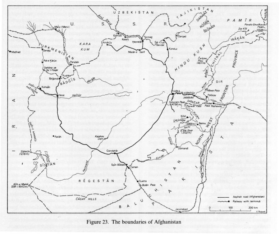
Afghanistan, the seventh largest landlocked country in the world in area (652,626 km2) is delineated by a boundary some 5,600 km long, over which it has never exercised more than partial control. It is surrounded by four countries: the USSR on the north (2,140 km of common boundary), Iran on the west (945 km), Pakistan on the south and east (ca. 2,430 km), and China on the northeast (76 km).
None of these boundaries was established before the last third of the 19th century. It was the “great game,” the famous rivalry between Britain and Russia in Central Asia, that led the latter two states to contemplate creating a buffer state between their respective dependencies, a kind of defensive barrier intended to eliminate all risk of direct confrontation between them. Thus Afghanistan in its present boundaries was born, the result of geostrategic games in which it played no independent part. The territorial definition of the country was an entirely exogenous process, especially as the role of the Kabul amirs was limited even further by Great Britain’s exercise of a de facto protectorate over the foreign policy of Afghanistan from 1879 to 1919, the main period in which the boundaries were being drawn; indeed, hardly a segment of the frontier was defined without direct diplomatic intervention by the British.
Having been dictated mainly by strategic imperatives of the colonial period, the present frontiers of Afghanistan are classic examples of artificial boundaries, including those frequent instances in which they follow important water courses or major mountain ridges: They all divide ethnolinguistic groups that share a common past and participate in a common culture. Contacts across frontiers, whether legal or not, have never ceased, however, except in the north, where the Chinese frontier is totally closed and the Soviet frontier passable only at a very few points.
Without recapitulating all the territorial vicissitudes of Afghanistan since its creation in 1160/1747 (see afghanistan x), the main stages in the delineation of each boundary can be outlined here and an effort made to describe the way in which it functions at present.
The Russo-Afghan boundary. The boundary between Russia and Afghanistan was the focus of the first efforts at delimitation. At the end of a Russian drive into Central Asia (capture of Tashkent in June, 1865; creation of the military governorate of Russian Turkistan in July, 1867; the war and subsequent treaty between Russia and Bukhara in 1868), which had considerably alarmed British authorities, the two governments opened negotiations in March, 1869, with the purpose of delimiting their respective zones of influence in the region: the amirates of Bukhara and of Khiva (Ḵīva), on one hand, and Afghanistan, on the other. The agreement was finalized in an exchange of letters between the British and Russian ministers of Foreign Affairs, Lord O. L. G. Granville (17 October 1872) and Prince A. M. Gorchakov (31 January 1873).
In line with a proposal put forward by the British in September, 1869, the northern frontier of Afghanistan was fixed on the Amu Darya from Lake Zor Kōl
(dubbed Lake Victoria by British explorers) in the Pamirs down to Ḵᵛāja Sālār (or Ḵᵛāja Ṣāleḥ), a distance of about 1,300 km. Ḵᵛāja Sālār, a point on the middle reach of the river, was later to prove less precisely defined than was believed at that time. East of Lake Zor Kōl, in a region of high mountains that was not well known, no boundary was drawn. To the west of Ḵᵛāja Sālār the two powers contented themselves with a vague boundary, recognizing that the districts of Āqča, Andḵūy, Šeberḡān, Sar-e Pol, and Maymana belonged to Afghanistan, without in any way defining their frontier along the Kara Kum desert. In Bādḡīs the agreement was even more vague, as it was considered that the Afghan frontier there was “well known and need not here he defined.” Such imprecision, which left the field open to the most varied interpretations, can be explained only by the fact that this stretch of the frontier separated the amirates of Kabul and Khiva, which at that time were both legally independent, whereas farther east the amirate of Bukhara was officially a vassal of Russia after 1868. The establishment of the Russian protectorate of Khiva in the months following the Granville-Gorchakov agreement, a prelude to the progressive occupation of Turkmenia (1873-84), revealed the scope of the misunderstanding; a clear demarcation of this northwestern part of the Afghan boundary, between the Amu Darya and the Harīrūd (Tajan, Tedzhen), thus became urgent.
This task was to be long and slow: It kept the Russian and British chancelleries busy from February, 1882, to January, 1888. In the absence of any physical feature on which to fix the line, it was soon agreed that the latter would follow as closely as possible the property and pastoral rights of the local populations: on one side, Turkmen who had been under Russian protection since the submission of Merv (Mary) in February, 1884, and, on the other, Uzbeks, Aymāq, and Pashtun, who were Afghan subjects. Implicit in this decision was the necessity for dispatching to the field a joint boundary commission charged with determining these rights, which involved investigations that grew more prolonged as they revealed an extraordinary patchwork of claims of chronic instability.
In November, 1884, the British half of the commission, under the direction of Major General Sir Peter S. Lumsden, set up headquarters at Kohsān, west of Herat, and began work. But its Russian counterpart did not join it there. The tsarist government, in fact, considered that the boundary had first to be more precisely defined before any attempt to mark it out on the ground could be undertaken. While the diplomats pursued negotiations on this point, the Russian army hastened to reinforce its local positions under the astonished eyes of the British commissioners, occupying Pol-e Ḵātūn and the Ḏu’l-Feqār pass (445 m), two indispensable crossing points on the steep right bank of the Harīrūd, and capturing the small Panjdeh oasis (now Taḵt-e Bāzār) at the confluence of the Morḡāb and Koškrūd, which the Afghans had held since June, 1884 (30 March 1885). The Russians thus found themselves in a strong position to dictate a frontier considerably farther south than any that had previously been suggested. This was the subject of a protocol signed in London on 10 September 1885. The Russians, while holding on to Panjdeh, gave up the Ḏu’l-Feqār pass to the Afghans; the border was fixed 3,000 feet (914 m) to the north of it. Generally speaking, however, the boundary was defined with increasing imprecision as it progressed toward the east.
The Russian boundary commissioners, led by Colonel P. Kul’berg, were then allowed to join the British commissioners; the latter had remained in position under the direction of Lieutenant Colonel J. W. Ridgeway, first deputy and then successor to Lumsden when the latter was recalled to London in May to participate in the last phase of negotiations. Qāżī Saʿd-al-Dīn Khan, future governor of Herat (1887-1904), represented Afghan interests but took no part in the official talks. The first boundary post was set up on 12 November 1885 north of the Ḏu’l-Feqār pass, and operations progressed toward the east with increasing slowness as the commission reached less well-known regions, about which the London protocol was vague. The discussions were particularly difficult in Bādḡīs, where the irrigation network posed insoluble problems, and in the Kara Kum desert, where the Russians took advantage of recent successful Turkmen raids to demand control of the maximum number of wells, in order to facilitate future patrols along the frontier.
The end of the delimitation operations was delayed by an unforeseen point of conflict: the question whether Ḵᵛāja Sālār, chosen in the agreement of 1872-73 as the terminus of that section of the boundary that followed the Amu Darya, was to be understood in its narrow sense as a tomb facing a disused ferry landing situated 23 km above Ḵamīāb, near Qarqūn, or more broadly as the district extending from Keleft to Ḵamīāb, inclusive, which was indisputably part of Afghanistan. The disagreement involved an area too vast (1,900 km2, of which only 68 were under cultivation; 19 wells; and 13,000 inhabitants) for the commissioners to be able to settle it, and they therefore broke up on 15 September 1886, having ceased their work north of Andḵūy. A new phase of negotiations was opened at St. Petersburg on 23 April 1887, and a compromise agreement was signed the following 22 July: Russia agreed to an Anglo-Afghan proposal that the boundary be fixed on the Amu Darya below Ḵamīāb in exchange for equivalent territory in Bādḡīs (2,136 km2, uninhabited but containing a well). Between November, 1887, and January, 1888, a limited joint commission proceeded to the corresponding rectifications of the boundary between the Koškrūd and the Morḡāb, as well as to the demarcation of its eastern section up to the Amu Darya. On 26 January 1888 a final protocol, signed at Ḵamīāb, brought the entire operation to an end. A total of 79 boundary posts had been set up along the 630 km of this most sensitive frontier, which an Afghan historian has proposed to call the “Ridgeway line” (M. Ali, Afghanistan. The Mohammedzai Period, Kabul, 1959, p. 136).
According to the British members of the commission, the boundary was “only an arbitrary line based on the circumstances of the moment rather than on any permanent and natural basis” and thus could not “be expected to be permanent” (Yate, 1888, pp. 178f.). It is all the more remarkable then that in the century since it was drawn it has given rise to only minor problems, all easily settled. The first occurred almost immediately, in 1891, after some Pashtun settlers had dug irrigation canals on the left bank of the international section of the Koškrūd, south of Qara Tepe (today Tōrḡondī). That was an undoubted infraction of the arrangements of 1887, which forbade all diversion of river waters in this sector, in order to ensure the water supply for Panjdeh. A joint Anglo-Russian commission was sent to the frontier to restore the previous situation. Ten years later, between October, 1903, and May, 1904, a new joint commission visited the frontier to repair several boundary posts that had been damaged; the British head of the commission was H. R. C. Dobbs. After the Russian Revolution of 1917, the Afghan government seized the opportunity to renew its claims to Panjdeh. The Afghan army actually advanced as far as Marv. The Soviet-Afghan friendship treaty of 28 February 1921 formally recognized the historic rights of Afghanistan in the region but made all retrocession of territory subject to a prior referendum among the local populations, which was never organized. The relevant article was, however, nullified by a protocol to the Soviet-Afghan frontier agreement of 1325 Š./1946 (see below).
The last portion of the Russo-Afghan boundary to be drawn was the eastern end. In Badaḵšān the Anglo-Russian agreement of 1872-73 had remained a dead letter. The upper course of the Amu Darya did in fact provide less of a natural boundary than the diplomats had believed. All the local Tajik principalities—Darwāz, a dependency of the amirate of Bukhara, and Rōšān and Šeḡnān, subject to Afghanistan—straddled the river. In addition, Amir ʿAbd-al-Raḥmān showed reluctance to take possession of the Wāḵān corridor, an extension of Badaḵšān, which the aforementioned accord had formally annexed to his territories. It seemed to him as indefensible strategically as it was devoid of economic interest. Frequent confrontations between Russian and Afghan armies in the region, which was becoming better known owing to the activity of Russian and British explorers (for example, the Ney-Elias mission, from May, 1885, to October, 1886), attested to the political instability of the area. At the beginning of 1886 Ridgeway contemplated extending the work of his commission to this part of the frontier. He even put in hand the necessary preparations for a stay on the spot, but the project was blocked at the last minute by an Afghan veto. It was not until 1893 that H. M. Durand, special envoy to Kabul, was able to break the impasse by obtaining from ʿAbd-al-Raḥmān an agreement to abandon all claims to the Transoxanian parts of Rōšān and Šeḡnān in exchange for the southern part of Darwāz and to accept incorporation of the Wāḵān into his territory in exchange for an increase of 50,000 rupees in his annual subsidy and the promise of British assistance in case of a Russian attack in the Pamirs. After having been for twenty years the legal northeastern boundary of Afghanistan, the upper Amu Darya thus became so in fact.
There remained only to define the boundary of the Wāḵān east of Lake Zor Kōl, a section on which the accord of 1872-73 was mute. Anglo-Russian negotiations were begun in 1893, and an agreement was signed on 11 March 1895. Following a scenario that had become standard, the two regional superpowers appointed a joint commission, headed by Major General M. G. Gerard and General Povalo-Shveĭkovskiĭ. In the following summer it laid out twelve boundary posts over 172 km, from Lake Zor Kōl to the peak of Qōqrāš Qōl, renamed Povalo-Shveĭkovskiĭ in honor of the Russian commissioner. This peak, the altitude of which is uncertain (5,698 m according to the Sino-Afghan boundary agreement of 1963; 5,543 m according to Atlas Tadzhikskoĭ S.S.R., Dushanbe and Moscow, 1968; and 5,433 m on Afghan topographic maps), marks the beginning of the Chinese Pamirs.
Some final details of the northern frontier of Afghanistan were settled by the Soviet-Afghan agreement of 23 Jawzā 1325 Š./13 June 1946, which stipulated that the boundary was to follow the middle of the main channel (median line, thalweg) of the Amu Darya. This matter was of considerable importance because of the meandering of the river in the entire lowland part of its course and its many interconnecting channels, which create islands of all sizes (1,192 have been enumerated). The largest among them, Darqad (or Ōrta Tūḡay), at the confluence with the Kyzylsu, has an area of 362 km2. Formerly a possession of the amirate of Bukhara, it was occupied by the Afghans at the end of the 19th century; retaken by the Russians in December, 1925, because it had served as a base for Basmachi raids into Soviet territory; and finally restored to Afghanistan by an accord dated 7 Ḥūt 1304 Š./26 February 1926. Today, with several less important neighboring islands, it constitutes one district of the province of Taḵār, the only island district in Afghanistan.
American allegations that the Soviet Union annexed the Wāḵān in 1981 have never been proved. On the contrary, in response to Chinese territorial claims in the region, the Soviet-Afghan treaty of 26 Jawzā 1360 Š./16 June 1981 reaffirmed the inviolability of the existing boundary between the two countries in the Pamirs.
For a long time after its delimitation the artificial northern boundary of Afghanistan continued to be crossed frequently by migrations and commercial traffic, whether regular or occasional, from nearby or far away. At the beginning of the 20th century there were still two caravansaries in Bukhara specifically for the lodging of Afghan merchants and caravans. The sovietization of Central Asia after 1924 brought the official closing of the frontier, which did not prevent significant numbers of Central Asian refugees from entering Afghanistan up to the middle of the 1930s. Nevertheless, over the years the frontier has been progressively sealed, with the construction of a chain of guard posts and more frequent patrols on the Soviet side. Today it is closed to all civilian traffic, though occasionally it is breached by clandestine groups of Afghan guerrillas (for example, raids against the city of Pyandzh, in Tajikistan, on 9 March and 8-9 April 1987). Commercial traffic can cross only at three frontier posts, which also serve as compulsory transfer points (Figure 23):
1. Tōrḡondī (formerly Qara Tepe), 120 km north of Herat, a transshipment junction between the Afghan highway network and a Soviet railroad branch that crosses the Koškrūd by a bridge, constructed in 1960, to its terminus 1 km inside Afghan territory. The distance of this hub from the capital (1,173 km from Kabul by road) and its sparsely populated hinterland explain the modest traffic: Only 3,039 freight cars were loaded or unloaded in 1360 Š./1981-82, an average of barely ten for each working day.
2. Šēr Khan Bandar (Qezel Qaḷʿa), 63 km north of Konduz, is a port on the Amu Darya. It is the northern frontier post closest to Kabul (394 km), and its Afghan hinterland is prosperous. It was for a long time the main crossing point between the Soviet Union and Afghanistan, but it has suffered from the absence of railway service or harbor infrastructure on the north shore of the river: The Soviet transshipment point is the large port of Termeḏ, 183 km downstream, which is linked to Šēr Khan Bandar by means of a fleet of river barges and small cargo boats.
3. Hayratān, 56 km north of Mazār-e Šarīf and 482 km from Kabul, is a new port across from Termeḏ, to which it is linked by a road and railway bridge (Pol-e Dōstī, bridge of friendship), officially inaugurated on 22 Ṯawr 1361 Š./12 May 1982. This bridge, which is 817 m long, 10.8 m wide, and 7.5 m above the average water level was initially proposed in 1969; it is the only one on the entire international section of the Amu Darya. Its total cost (33.7 million rubles) was shared between the USSR and Afghanistan; the 50 percent Afghan share was financed by a long-term credit from the Soviet Union. At the Afghan end a modern harbor complex and a new city have been built. Hayratān has become the principal transshipment point for Soviet-Afghan trade and, since 1980, Afghanistan’s main opening to the outside world.
Under the direction of a special department of the Ministry of Commerce, the two Afghan river ports unloaded 1,854 boas and loaded 1,519 in 1360 Š./1981-82.
The recent establishment of Hayratān has led to the abandonment of two harbor sites that had flourished briefly farther downstream, neither with a quay or any fixed installation and also without any modern highway link: Tāšgoḏar and Keleft, 16 and 110 km from Termeḏ respectively. Keleft, once only an import station, is today no more than the exit point for the pipeline, 103 km long and 820 mm in diameter, which carries part of the natural gas from Jowzjān (Jūzjān) out of Afghanistan.
The Sino-Afghan boundary. South of Povalo-Shveĭkovskiĭ peak the Afghan frontier was not demarcated through the Lesser Pamirs until 1 Qaws 1342 Š./22 November 1963, the date of the signing at Peking of a boundary agreement between the two countries. The following summer a joint commission arrived in the field to demarcate the boundary, and a final protocol was signed in Kabul in March, 1965.
The principle followed was very simple: The frontier (76 km) follows, at an altitude of more than 5,000 m, one of the major watersheds on the Asian continent, that which separates the Amu Darya basin to the west from the Tarim basin to the east (see the detailed map published in Prescott, p. 239). It is intersected by several passes the most important of which, the Waḡjīr pass (4,923 m), negotiable only in summer, was used until 1949 by caravans from Kāšḡar and by Chinese pilgrims to Mecca (Sharani, 1979, pp. 41ff.). Today this boundary is totally closed.
The Pakistani-Afghan boundary. The boundary with Pakistan is the longest of Afghanistan’s frontiers: It runs from the Pamirs to the borders of Sīstān, about 2,430 km, its course reflecting a century-long process of eliminating the Afghan presence from the north Indian plains, first through incursions of the Sikhs from Punjab (entailing the loss of Multan in 1818, of Dērajāt in 1821, and finally of Peshawar, the former winter capital of the amirs of Kabul, in 1834), then through the decisive intervention of British colonial imperialism.
For a long time the British remained indecisive about where to halt their conquests in the west. This uncertainty particularly affected the tribal populations of Baluchistan (Baluch and Brahui) and the Solaymān mountains (Pashtun), which had always lived along the borders, and largely at the expense, of the great regional empires, their whole way of life being centered around predatory raids. Faced with what amounted to a buffer zone between the Safavid and Mughal empires, the British newcomers had two main options. The first was occupation pure and simple, in order to pacify the inhabitants, which would have established the Indo-Afghan border on the western piedmont of the Solaymān mountains following a line from Jalālābād to Qandahār passing through Kabul and Ḡaznī, along the crest of the Hindu Kush; or even on the Amu Darya: the “scientific frontier” of India favored by such extremists as R. Sandeman (1835-92). The alternative was to limit contacts and causes of friction with the Pashtun and the Baluch by prudently fixing the Anglo-Indian frontier outside their territory along a line from Peshawar to Bannu to Jacobabad, parallel to the Indus, or even on the Indus itself, the only really natural northwestern frontier of India: the “close border” proposed, for example, by the viceroy J. Lawrence (1811-79). After much hesitation, a compromise solution had to be adopted.
The increase in Pashtun raids on the Indus plains led to the temporary success of the partisans of the first solution. The “forward policy” adopted at their urging produced a series of decisive British advances toward the west: the establishment of a protectorate over the Khanate of Kalat in 1876, concomitant occupation of Quetta and the Bolān pass, and in 1878 occupation of several territories belonging to Afghanistan in the middle Kurram valley as far as the Paywār pass, the Afridi country around the Khyber (Ḵaybar) pass, and subsequently (during the second Anglo-Afghan war) the entire southeastern portion of present-day Afghanistan. The evacuation from Afghanistan in 1881, however, sounded the death knell of the maximalist frontier policy, at the same time reviving Afghan territorial claims in the Solaymān mountains and Baluchistan. In order to forestall a major frontier crisis and to guarantee permanently the advantages already gained, the British government then agreed to a compromise boundary. H. M. Durand, at that time secretary in the Indian Foreign Department, was charged with negotiating this boundary with Amir ʿAbd-al-Raḥmān himself. His mission to Kabul, initially planned for 1888, could not finally take place until September-November, 1893. The boundary defined by the agreement of 3 Jomādā I 1311/12 November 1893 was known from the start as the “Durand Line,” a name still in use today. It reserved to Great Britain Chitral and control of the passes on the main access routes to India, either total (Khyber, Bolān) or partial (Paywār), but it ceded to Afghanistan the middle Konar valley around Asmār, western Waziristan (the Bermal district), and the northern slopes of the Čāgay hills in Baluchistan. A number of major rivers and mountain ranges, as well as several traditional tribal territories, were thus bisected by a boundary that is certainly the most unsatisfactory and the most artificial that can be imagined.
Durand, in the meantime named minister plenipotentiary to Tehran, took no part in the actual demarcation of the boundary that bears his name. The main part of the work took place from April, 1894, to May, 1896, but a certain number of problems remained unsolved. The Kabul agreement was in fact so imprecise and the map annexed to it on so small a scale that differences in interpretation were innumerable and sometimes of long duration. Because of the length of the frontier, it was divided into four sectors, each assigned to a separate boundary commission.
It was the Hindu Kush commission, under the direction of R. Udny and Ḡolām Ḥaydar Khan Čarḵī, that confronted the greatest difficulties. For the area from the Pamirs to the Čarḵaw (or Dōrāh) pass (4,550 m), a major traditional route between India and northern Afghanistan (through the Sanglēč valley), agreement was reached, without inspection of the terrain, to draw the boundary along the crest of the Hindu Kush, which separates the hydrographic basin of the Amu Darya from that of the Indus. Farther south, in the middle Konar basin, the first disagreement arose over the Bašgal valley: In the 1893 agreement it had been explicitly included in India, but the Afghans demanded its return before signing the protocol of Našāgām (13 Šawwāl 1312/9 April 1895); this protocol precisely defined the boundary between the Čarḵaw and Nāwa passes (1,853 m). In the single section where it did not coincide with the watershed, that is, at the confluence of the Konar and Bašgal rivers, the boundary was not demarcated until much later (protocol of 20 Saraṭān 1311 Š./11 July 1932). On the other hand, differences over the particularly sensitive region of the lower Kābolrūd and the approaches to the Khyber Pass south of the Nāwa pass proved insurmountable. The Afghans claimed the entire tribal territory of the Mohmand (q.v.), whereas the British proposed partition. The boundary in this sector remained imprecise and in dispute until August, 1919, the date on which the treaty of Rawalpindi, which brought to an end the third Anglo-Afghan war, settled the problem in conformity with initial British demands. The English commissioner, J. L. Maffey, chief political officer of the North-West Frontier Province, proceeded immediately to set up thirteen boundary posts from the crest of the Spīnḡar to Palōcay on the Kābolrūd. Beyond that point, between Palōcay and Nāwa, the frontier is said to follow the watershed, though no survey was ever undertaken. In the Kābolrūd valley itself, the Anglo-Afghan treaty of 30 ʿAqrab 1300 Š./22 November 1921 introduced several minor rectifications of the frontier to the advantage of Afghanistan.
On other sections of the Durand Line the work of demarcation was easier, even though it was never entirely free from argument. The Kurram commission, under the direction of J. Donald and the sardār Šīrīndel Khan, was able to complete its work in a few months: The protocol of Kōtgay (22 Jomādā I 1312/21 November 1894) listed the seventy-six boundary posts that had been erected between Sekaram peak (4,790 m), the highest point in the Spīnḡar, and Mount Laṛūmī (Laṛūmīḡar, called Laram Peak in the British documents; 2,058 m), southeast of Ḵōst. The boundary line here respects major tribal and religious alignments: It separates the Shiʿite Pashtun tribes in the east (Tūrī, Bangaṧ) from their Sunnite neighbors in the west (Jājī, Mangal, etc.).
The Waziristan commission, placed under the sole direction of an English officer, R. I. Bruce, at the express request of Amir ʿAbd-al-Raḥmān, had to perform a drastic partition, separating the Wazīr of Afghan Bermal from their eastern cotribesmen. In view of the difficulty of the task, it divided into two subcomissions. In the north, between Mount Laṛūmīḡar and Mount Ḵᵛāja Ḵedr (3,122 m), the boundary cuts across the hydrographic basin of the Tochi; H. A. Anderson demarcated it with thirty-eight boundary posts. In the south, between Ḵᵛāja Ḵedr and Domandī (Dwamanḍī), at the confluence of the Gōmal (Gūmal) and the Kundar, L. White King set up thirty-one boundary posts over a distance no greater than 81 km. The work was finished there in March and April, 1895.
Finally, the Baluchistan commission had responsibility for the entire southern boundary of Afghanistan, from Domandī to the borders of Sīstān. Under the supervision of a single British commissioner, Captain A. H. McMahon, and two successive Afghan commissioners—first the sardār Gol-Moḥammad Khan for the section between Domandī and Čaman, the point at which the frontier cuts the Qandahār-Quetta road, then Moḥammad-ʿOmar Khan Nūrzay for the remainder—no fewer than 196 boundary posts were required. The final protocol was signed 29 (sic; really 30) Ḏu’l-qaʿda 1313/13 May 1896.
The Anglo-Afghan agreement of 1893, the basic document establishing the Durand Line, defined the latter as the frontier between the “respective spheres of influence” of Afghanistan and Great Britain and not as a formal international boundary. The expression “Indo-Afghan frontier” appeared for the first time only in the 1919 and 1921 treaties cited above. The tribal territories east of the Durand Line benefited throughout the entire colonial period from a statute granting them broad internal autonomy under British administrative tutelage. In 1928 the Royal Stationary Commission (or Simon Commission), charged with the administrative reorganization of the North-West Frontier Province, observed that “British India stops at the boundary of the administered area” (i.e., the boundary between the Tribal Agencies and the Settled Districts of British India; cited in Dupree, 1961, p. 94). Between it and the Durand Line only the permanent presence of forty-eight battalions of the Indian Army and the payment of annual subsidies to the tribes attested to British colonization. The Tribal Agencies constituted a sort of tribal variant of the princely states on the Indian subcontinent. Furthermore, Afghanistan was able to maintain continuous influence over them by means of the regular despatch of emissaries and the invitation of tribal delegations to Kabul. There were thus plenty of arguments, which the Afghan government did not fail to advance, in opposition to the procedure of annexing the region to Pakistan in 1947.
The referendum that the British organized in the Tribal Agencies at the eleventh hour offered only two alternatives: annexation to India or to Pakistan. It excluded all possibility of independence, in contrast to what was offered to the princely states of India, as well, of course, as any possibility of annexation of Afghanistan, which Kabul had demanded. In these circumstances the Afghan government took up the cause of local partisans of an independent Pathanistan, or Pashtunistan. Afghanistan was the sole member of the United Nations to vote against the admission of Pakistan (30 September 1947), and a short time later it formally denounced all Anglo-Afghan frontier accords (4 Asad 1328 Š./26 July 1949). Since that date the Pakistani-Afghan boundary has not been officially recognized. It is therefore not drawn on the large-scale topographical maps produced by the Cartographic Institute of Kabul.
The issue of Pashtunistan has continuously poisoned relations between Afghanistan and Pakistan. It even led to serious tension in 1949-50, 1955, and 1959, each instance leading to a partial blockade of the common boundary and a progressive shift of Afghan foreign trade to new transit outlets. The signing of the first transit agreements between Afghanistan and the USSR (27 Saraṭān 1329 Š./18 July 1950) and Iran (12 Qaws 1339 Š./3 December 1960) respectively coincided with periods of heightened border tension with Pakistan. The crisis culminated in 1961 with the severing of diplomatic relations between the two countries and the closing of their common frontier to all traffic in both directions from 12 Mīzān 1340 Š./3 September 1961 to 8 Jawzā 1342 Š./29 May 1963, except for an eight-week period from January to March, 1962, when the import of American aid supplies to Afghanistan was permitted. This episode marked a decisive stage in the development of Afghan foreign trade through the USSR, as well as in the decline of seasonal migration of nomads across the Pakistani border.
Since the Soviet intervention in Afghanistan (December, 1979) frontier incidents and violations have increased. A number of refugee camps established on the Pakistani side of the frontier serve as launching bases for guerrilla expeditions into Afghanistan.
Even during periods of high border tension, the Durand Line has always remained the most permeable of all Afghan boundaries. It is breached at a great number of points, both in densely populated mountain areas and in unpopulated deserts, by a varied traffic of men, animals, and goods, continuing the age-old interdependence between the temperate highlands of Afghanistan and the tropical lowlands of India.
Human migration across the frontiers has undergone profound alterations in the course of the 20th century. The traditional flow of the powenda, Afghan nomadic herders or seasonal workers going to spend the winter on the Indus plains, declined steadily until 1979. In 1978 the number of Pashtun nomads crossing the boundary, mainly through the Gōmal valley, was fewer than 50,000. In addition, there was an indeterminate but much smaller number of Baluch nomads from Afghanistan who spent the summers in the mountains of northern Pakistani Baluchistan. On the other hand, an important tourist influx from Pakistan began in 1965-66, when first Kabul and then Qandahār were linked to the frontier by a good asphalt road. Opportunities for leisure (Indian films!) and commerce (a free money market, abundant imported consumer goods) attracted as many as 50,000 Pakistani visitors a year (1970). Since 1979 this traffic has dried up, owing to danger from the war. But the exodus of Afghan refugees has once more demonstrated the extraordinary permeability of the Pakistani-Afghan border.
The Durand Line is officially open to foreign trade only at two frontier posts: Torḵam, 224 km east of Kabul, and Spīn Bōldak, 104 km east of Qandahār. Between 70 and 80 percent of all official exchanges across the frontier pass through Torḵam. Successive commercial conventions between Afghanistan and Pakistan (for example, those of 8 Jawzā 1339 Š./29 May 1960 and 11 Ḥūt 1344 Š./2 March 1965) have repeatedly reaffirmed the principle of free circulation for trucks from both countries between the railway termini at Peshawar (55 km from Torḵam) and Čaman (8 km from Spīn Bōldak), on one hand, and Kabul and Spīn Bōldak, on the other. Pakistan prohibits trucks from traveling between Afghanistan and India, however.
Beside this legal traffic there is a very important contraband trade, carried mainly by animals but also by truck. It involves a very wide range of agricultural products (Afghan fruits, Pakistani grains) and manufactures (legally imported consumer goods illegally reexported by Afghan businessmen, Pakistani textiles and cigarettes). In 1972 it was estimated at several hundred million Pakistani rupees a year (Ghani Mohammad Khan, 1972). The principal depots for smuggled goods are located on the eastern side of the Khyber pass, at Landī Kōtal and Bara.
The export of Afghan lumber has always followed special routes. This trade was legal until 6 Dalw 1353 Š./26 January 1975, on condition that exclusively animal transport be used; it involved seven mountain tracks in the Paktīā, an eighth through the Paywār pass having been closed since 16 Dalw 1348 Š./5 February 1970. Furthermore, lumber rafts from Nūrestān were floated across the border on the Kābolrūd. Since 1975 the export of wood has been totally forbidden, but an important illicit trade does continue,
The Iranian-Afghan boundary. The boundary between Afghanistan and Iran, which runs in a generally north-south direction, cuts through what is conveniently called the “Iranian plateau.” The present political division of this great geographical and cultural unit goes back to the 18th century, when two rival powers emerged from the ruins of the Safavid empire, the Dorrānī empire on the east and the Qajar empire on the west. After a long period of fluctuation the boundaries of their respective spheres of influence were stabilized, once Dōst-Moḥammad Khan, amir of Kabul, had taken Herat (8 Ḏu’l-ḥejja 1279/27 May 1863). From then on the definition of a boundary line between the two states was no more than a secondary issue, but, despite its short length (945 km), the process of delimitation was very long (1872-1935). It was carried out in three stages, corresponding to three different sectors of the frontier, entirely by neutral arbitration commissions, British at first, then Turkish, the latter a unique occurrence in the history of the boundaries of Afghanistan.
It was in the south, in Sīstān, that the need for a precise boundary was felt most urgently. The Sīstān endorheic basin (ca. 90,000 km2), which encompasses the outlet of the Helmand and several other less important water courses, is actually the only densely populated area on the border between Iran and Afghanistan. It thus has great strategic importance. In the middle of the 19th century it was a disputed border area, where Kabul and Tehran struggled for the allegiance of local chiefs. Profiting from the years of anarchy into which Afghanistan had sunk after the death of Dōst-Moḥammad (1279/1863), the Iranians advanced farther into the region and succeeded even in establishing a foothold on the right bank of the Helmand, occupying Nād-e ʿAlī in 1865. When Šēr-ʿAlī Khan seized the throne at Kabul (1285/1868), the threat of a violent Afghan reaction persuaded Nāṣer-al-Dīn Shah to ask for British arbitration, in conformity with article 6 of the treaty of Paris (4 March 1857), which obliged him to “refer for adjustment to the friendly offices of England any differences that might occur between Persia and Herat or Afghanistan.” A Sistan Arbitration Commission, composed of four British officers under the direction of Colonel F. J. Goldsmid, the same man who had just finished demarcating the boundary between Iran and the Khanate of Kalat (1871), did visit the area in February, 1872. But in the face of systematic obstruction by the official representative of the shah, Maʿṣūm Khan, it remained only forty-one days in Sīstān, and Goldsmid announced the outcome of his arbitration from Tehran on 19 August. The lower Helmand, from the Kohak dam (Band-e Sīstān) to its outlet in the reed marshes (nayzār) of Hāmūn-e Pūza(k), was chosen as the boundary between Sīstān “proper” on the west, which was awarded to Iran, and the much less densely populated “outer” Sīstān on the east, which was granted to Afghanistan. From these two points the frontier follows a simple straight line toward two prominent summits in the foothills of the mountain range that separates Sīstān from the Dašt-e Lūt: the Sīāhkūh (or Kūh-e Narāhū, 1,278 m) in the north and the Kūh-e Malek Sīāh (1,643 m) in the south, the latter being one of the points where Afghan territory comes closest to the sea (510 km from the Gulf of Oman and the strait of Hormuz). Altogether 300 km of frontier were thus defined, though not demarcated. “The requisite supply of water for irrigation” was guaranteed to each part of Sīstān, but the arbiters did not specify what that phrase meant.
That the Goldsmid arbitration undoubtedly favored Iran over Afghanistan is clear from Šēr-ʿAlī Khan’s manifest unwillingness to ratify it. He did not consent until October, 1873, after having obtained payment of an indemnity of 1.5 million rupees in compensation.
Whether the British deliberately chose to create a permanent focus for regional tensions and thus to perpetuate their own influence in the area (the interpretation of Abidi, 1977) or whether the award resulted simply from lack of information from the field, the Goldsmid arbitration was very soon revealed as seriously inadequate, particularly in the sites chosen for frontier landmarks. These sites were geographically unstable, lying either along the spreading river channel typical of a delta plain or on the ephemeral shore of a lake the area of which varies considerably from one season and one year to another. These choices alone provided several potential sources of frontier conflict, not to mention the disputes that were certain to arise over the thorny question of sharing the Helmand waters between two rival riverine states, especially in drought years.
In 1896 exceptional flooding caused a shift in the main channel of the Helmand delta from the eastern Sīḵsar branch to an old irrigation canal, the Rūd-e Parīān, situated farther west and entirely in Persian territory, thus threatening the irrigation of Afghan Sīstān. At first, however, local authorities managed to solve the problem by mutual agreement: Construction of an earth dam on the Rūd-e Parīān permitted restoration of the flow in the Sīḵsar. But in 1902, a year of great drought, shortage of water led to embittered relations between the frontier populations of Sīstān, and there were even armed skirmishes, following which the British were again requested to act as arbiters in redefining the frontier unambiguously and to develop a precise formula for division of the Helmand waters. This role devolved upon the Sistan Boundary Commission, under the direction of a man who knew the southern boundaries of Afghanistan well, Colonel A. H. McMahon. The commission remained in the field for more than two years (February, 1903-April, 1905). Despite Persian claims to a part of Sīstān that had been granted to Afghanistan in 1872, no plan to alter the Goldsmid award was ever contemplated. The most McMahon’s team could do was to amend it. For example, the boundary originally settled on the Sīḵsar, which had since dried up, was shifted to a series of mounds along its course, sometimes on the right (Afghan) bank, sometimes on the left (Persian) bank. Eighty-nine boundary posts were set up along its entire length. Finally, after meticulous investigations the reports of which still serve today as a documentary source of the first rank, the commission granted to Iran one third of the Helmand flow at its entry into Sīstān and made the two riverine states equally responsible for the proper supply of water to the existing irrigation network, whatever might be the subsequent shifts in the river’s delta branches.
These measures were not sufficient, however, to prevent differences over the frontier from recurring once large irrigation works undertaken by Afghanistan in the middle Helmand valley after 1946 threatened the water supply for the whole of Sīstān. After bilateral negotiations had failed, a neutral tripartite Helmand River Delta Commission (Komīsyūn-e Deltā-ye Helmand) was named, with members from Canada, Chile, and the United States (1951). It specified the volume of water that Afghanistan had to cede to Iran in each month of the year (minimum 1.98 m3/sec in September, maximum 66.12 m3/sec in February, annual average 22 m3/sec). Afghanistan accepted the arbitration but not Iran, which demanded more. The dispute thus remained dormant for two decades, only to heat up again in 1350 Š./1971, another year of severe drought. This time bilateral negotiations were opened in a friendly climate conducive to a rapid solution: The Afghan-Iranian Helmand River Water Treaty was signed at Kabul on 22 Ḥūt (= Esfand) 1351 Š./13 March 1973. Iran obtained a slightly larger share of the Helmand waters (an annual average of 26 m3/sec, compared to 22 m3/sec in 1951), with proportional abatement in case of a measured drop in the river flow above the Kajakay reservoir dam. Ratification of the treaty by Afghanistan was delayed by the fall of the royal government in the following July and by the launching of a violent campaign to rouse public opinion against the “giveaway” of the Helmand waters. It was only on 15 Jawzā (= Ḵordād) 1356 Š./5 June 1977 that the instruments of ratification could be exchanged in Tehran, thus putting an end to a century-old frontier dispute.
The delimitation of the other sectors of the Iranian-Afghan frontier raised many fewer difficulties, for they involved regions that were not permanently inhabited but simply served as winter pastures for nomads, without any real economic value, as in the evocatively named Dašt-e Nawmēd (desert of desolation).
South of the bend in the Harīrūd the contested district of Dašt-e Haštādān, so named because it supposedly includes ruins of eighty qanāts, was divided between the two countries in December, 1889, through the arbitration of Major General C. S. MacLean, then British consul general for Khorasan and Sīstān. In 1890-91 he erected thirty-nine boundary posts along 66 km. This operation was rapidly followed by the creation of small, permanently inhabited oases on both sides of the frontier, but especially on the Iranian side. Farther north the meandering bed of the Harīrūd constitutes one of the most stable and least disputed frontiers in all of Central Asia. No bridge spans any part of the 157 km of its length that serve as boundary between Iran and Afghanistan.
As for the central part of the frontier between Haštādān and Sīstān, it remained unsettled for a long time. From time to time frontier disputes did occur there, which, in June, 1928, led Iran and Afghanistan to sign an agreement defining procedures for peaceful resolution, then to contemplate outright demarcation of the frontier. By common agreement they resorted to arbitration by a neutral state with which both had good relations, Turkey. It was a Turkish commission, under the direction of General Fahreddin Altay, that between October, 1934, and May, 1935, drew a boundary more than 400 km long and subsequently laid it out with forty-eight boundary posts. The same commission erected five additional boundary posts on the left bank of the Harīrūd to supplement those that had been set up forty-five years earlier by MacLean. The process of fixing the borders of Afghanistan was thus completed.
In economic terms the boundary between Iran and Afghanistan is the least important of the frontiers of Afghanistan. Aside from smuggling, which is not negligible and involves mainly export of animals for butchering in Iran, where prices are higher than in Afghanistan, it is open to commercial traffic only at the frontier post of Eslām-Qaḷʿa (formerly Kāfer-Qaḷʿa), 120 km west of Herat, 32 km from the Iranian post at Yūsofābād, and 250 km from the railway terminus at Mašhad. An Iranian-Afghan trade agreement, which has been renewed regularly since 1960, authorizes trucks from both countries to travel between Herat and Mašhad. In an attempt to compensate Afghanistan for the provisions of the Helmand Water Treaty of 1973, the measure was extended in September, 1974, to cover the entire highway networks of both nations, and Iran in addition granted deep-water port facilities and preferential rail freight rates to cargo going to or coming from Afghanistan. Traffic across the frontier increased very little, however; the distance from the Mašhad railhead, on one hand, and failure to carry out plans for a direct route to the nearest port, Bandar-e ʿAbbās, on the other, have ensured that the main portion of Afghan foreign trade continues to pass either through Karachi or the USSR.
Bibliography
Works on the geography or contemporary history of Afghanistan rarely fail to raise the question of frontiers, particularly their delimitation. Only specific titles will be cited here. Nor will an exhaustive list be given of the scientific results of the boundary-demarcation surveys, which still remain invaluable for geographic, geological, climatological, botanical, zoological, ethnological, and historic knowledge of the regions where they were conducted.
General: The basic work is J. R. V. Prescott, Map of Mainland Asia by Treaty, Carlton, Australia, 1975, esp. pp. 99-211, 238-41.
All the official texts defining the Afghan frontiers have been conveniently brought together there, accompanied by a very detailed historical commentary. The only historical study specifically devoted to the origins of the entire Afghan frontier is R. I. Malhotra, Afghan Search for Identity. Frontier Settlements 1872-1893, Delhi, 1982.
The problem is approached in a more superficial manner in Chapter 3 of R. Gopalakrishnan, The Geography and Politics of Afghanistan, New Delhi, 1982.
Soviet-Afghan boundary: Afganskoe razgranichenie, 2 vols., St. Petersburg, 1986.
Afghan Boundary Commission, Records of Intelligence Party, 5 vols. + 2 index vols., Simla, 1887-92. H. Dobbs, Diary 1903-04, National Archives of India, New Delhi, unpublished.
H. V. Fitzhardinge, The Establishment of the North-West Frontier of Afghanistan, 1884-1888, Ph.D. dissertation, The Australian National University, Canberra, 1968 (a fundamental work that unfortunately remains unpublished).
M. G. Gerard et al., Report on the Proceedings of the Pamir Boundary Commission 1896, Calcutta, 1897.
J. Glaubitz, “Zur Veröffentlichung des sowjetisch-afghanischen Vertrags über den Grenzverlauf im Pamir Gebiet,” Asien 7, 1983, pp. 57-67.
R. S. Rastogi, Russo-Afghan Boundary Disputes 1870-1900, Lucknow, 1976.
U.S. Department of State, Office of the Geographer, Afghanistan-U.S.S.R. Boundary, International Boundary Study 26, Washington, D.C., 1963; 2nd ed., 1983.
A. C. Yate, England and Russia Face to Face in Asia. Travels with the Afghan Boundary Commission, London, 1887.
C. E. Yate, Northern Afghanistan, or Letters from the Afghan Boundary Commission, Edinburgh and London, 1888; repr. Lahore, 1976.
Sino-Afghan boundary: M. N. M. Shahrani, The Kirghiz and Wakhi of Afghanistan. Adaptation to Closed Frontiers, Seattle, 1979.
U.S. Department of State, Office of the Geographer, Afghanistan-China Boundary, International Boundary Study 89, Washington, D.C., 1969.
Pakistani-Afghan boundary: W. P. Andrew, Our Scientific Frontier, London, 1880 (for an expression of the maximalist British position).
L. Dupree, “The Durand Line of 1993: A Case Study in Artificial Political Boundaries and Culture Areas,” in Current Problems in Afghanistan, Princeton, 1961, pp. 77-93.
A. T. Embree, ed., Pakistan’s Western Borderlands, New Delhi, 1977; repr. Karachi, 1979. Ghani Mohammad Khan, Afghanistan’s Transit Trade through Pakistan and the Unrecorded Transactions at Landikotal, Peshawar, 1972 (roneo).
W. R. Hay, “Demarcation of the Indo-Afghan Boundary in the Vicinity of Arandu,” The Geographical Journal 82/4, 1933, pp. 351-54.
T. Holdich, The Indian Borderland, 1880-1900, London, 1901.
K. M. Khan, “Der Paschtunistan-Konflikt zwischen Afghanistan und Pakistan,” in K. M. Khan and V. Matthies, eds., Regionalkonflikte in der Dritten Welt, Weltwirtschaft und Internationale Beziehungen 21, Munich, 1981, pp. 283-384.
A. H. McMahon, “The Southern Borderland of Afghanistan,” The Geographical Journal 9/4, 1897, pp. 393-426.
S. Q. Quddus, Afghanistan and Pakistan. A Geopolitical Study, Lahore, 1982.
P. Sykes, The R. H. Sir Mortimer Durand. A Biography, London, 1926; repr. Lahore, 1977.
G. P. Tate, The Frontiers of Baluchistan. Travels on the Borders of Persia and Afghanistan, London, 1909, repr. Lahore, 1976.
M. E. Yapp, Strategies of British India, Britain, Iran and Afghanistan 1798-1850, Oxford, 1980 (the best historical study of the premises of the frontier debate).
Many polemical works have been devoted to the problem of Pashtunistan. See, for example, K. McLachlan and W. Whittaker, A of Afghanistan, Wisbech, 1983, pp. 286-88.
Iranian-Afghan boundary: A. H. H. Abidi, “Irano-Afghan Dispute over the Helmand Waters,” International Studies (New Delhi), 16/3, 1977, pp. 357-78.
The Afghan-Iranian Helmand River Water Treaty, Kabul, Ministry or Information and Culture, n.d. (1351 Š./1972; text of the treaty in Pashto, Persian, and English).
D. C. Champagne, The Afghan-Iranian Conflict over Herat Province and European Intervention 1796-1863. A Reinterpretation, Ph.D. dissertation, University of Texas, Austin, 1981 (unpublished; fundamental on the fluctuation of the spheres of Persian and Afghan influence in the Herat region in the 19th century).
F. J. Goldsmid, ed., Eastern Persia. An Account of the Journeys of the Persian Boundary Commission 1870-71-72, 2 vols., London, 1876.
R. L. Greaves, “Sistan in British Indian Frontier Policy,” BSOAS 49/1, 1986, pp. 30-102. A. H. McMahon, “Recent Survey and Exploration in Seistan,” The Geographical Journal 28, 1906, pp. 209-28, 333-52.
M.-ʿA. Moḵber, Marzhā-ye Īrān, Tehran, 1324 Š./1945.
Perso-Afghan Arbitration Commission, Irrigation Report, 2 vols., Simla, 1906.
Idem, Revenue Report and Notes, 3 vols., Simla, 1906.
A. Tawakkolī, Rawābeṭ-e sīāsī-e Īrān o Afḡānestān, n.p. (Tehran), n.d. (1326 Š./1947).
U.S. Department of State, Office of the Geographer, Afghanistan-Iran Boundary, International Boundary Study 6, Washington, D.C., 1961.
K. Vadiie, Les frontières irano-afghanes, annex memoir for the doctorate of the university, Faculté des Lettres of Paris, 1955 (unpublished). [A. Jahānbānī, Sargoḏašt-e Balūčestān o marzhā-ye ān, Tehran, 1338 Š./1959.