


CLIMATE. Both the climate of Persia as a whole and the differences in weather among its various regions are determined primarily by its location within the arid belt of the eastern hemisphere. The general dryness and barrenness of the country result from its position in relation to the planetary circulation system and are further heightened, as well as internally differentiated, by the mountain ranges encircling much of its perimeter, specifically the Alborz and the Zagros. On one hand, these high barriers prevent moist Mediterranean and Caspian winds from reaching the Persian plateau and thus ensure the extreme dryness of the greater part of central Persia; on the other, the outer flanks of the mountains are subject to sometimes heavy precipitation, so that they differ fundamentally from the plateau in their ecology and prevailing forms of human activity and land use.
Climate and weather. The Persian national weather service first began publishing its observations only in the year 1335 Š./1956, when a network of synoptic observation stations was first constructed in conformity with international standards; detailed data for many parts of the country are thus available for only about twenty-five or thirty years. The most important sources of information are the meteorological yearbooks that have appeared annually since 1335 Š./1956. On the basis of these data it has become possible to understand the place of Persia within the framework of climatic divisions of the earth’s surface.
In W. Köppen’s classification the largest portion of Persian territory appears to fall into the dry-steppe (semiarid; BS) and dry-desert (arid; BW) zones. The climates of the plateau and the southern coastal area can be further classified as colder (BSk or BWk) or warmer (BSh or BWh) respectively, the boundary being the 18° C annual isotherm. According to Köppen, only the upland areas of the Alborz and the Zagros can be classified as having a subtropical dry-summer climate (Csa), whereas the northern slopes of the Alborz and the Caspian lowlands belong to the category of subtropical humid climates (Cf).
In the more refined classification of C. Troll and K. H. Paffen, in which seasonal contrasts in humidity and aridity are also taken into account, most of Persia falls into two subcategories of the warm-temperate subtropical zone: the dry-summer steppe climates with humid winters (IV2), to which the greater part of the country obviously belongs, and the semidesert and desert climates (IV5), which are especially typical of the large stream basins on the uplands. The Zagros area is an exception in that it belongs to Troll and Paffen’s climate type IV 1, the dry-summer Mediterranean climates with humid winters.
In the system of global atmospheric-pressure and wind belts Persia straddles the boundary zone between the northeasterly tradewinds that prevail in summer and the rain-bearing westerlies of winter. The rhythm of seasonal shifts in these zones of atmospheric pressure has a major impact on climate, which is further influenced and modified by variations in topography, as well as by the distribution of land and water masses. In the winter the clash between cold continental air masses from Siberia and Central Asia, on one hand, and not uncommon warm, moist Mediterranean currents from the west, on the other, is the prime determinant of prevailing weather patterns in Persia. Local factors can, however, cause extreme variations, ranging from high-pressure areas over the wintry northern plateau (1,204 mb) to warm low-pressure areas over the Caspian Sea in the north (1,018 mb) and Lārestān on the Persian Gulf coast (1,016 mb). This characteristic contrast in atmospheric pressure between northern and southern Persia is even greater in the summer, when a powerful local high-pressure area (1,012 mb) occurs over the relatively “cool” Caspian Sea and at the same time one of the most extreme thermal low-pressure areas (994 mb) on earth develops in the south. Throughout the year, then, more or less powerful contrasts in atmospheric pressure between north and south dominate the climate and weather patterns of the country.
These zones of atmospheric pressure, which are extensive and for the most part clear-cut, are modified to some degree by regional and local wind systems. Among a large number of such systems in Persia two call for particular comment: one is a system of mountain winds that are channeled down the slopes and through the valleys, thus intensifying the effects of the steep terrain, the other is a coastal system that affects a relatively limited expanse of territory. In autumn the mountain winds blow along the margins of the Alborz and the Zagros, bringing warm, dry currents especially to the Caspian lowlands but also causing occasional breaks in the prevailing humidity of Ḵūzestān and parts of the Persian Gulf coast. In Ḵūzestān they often bring frosts, which endanger the subtropical sugarcane crop; in the highlands, however, it is their great velocity that causes damage, particularly in the Alborz passes at elevations of 2,000-2,500 m, the fluctuating boundary zone between these dry mountain winds and moister currents from the Caspian. In the upper Safīdrūd valley near Manjīl and in the Talār valley near Gadūk and Fīrūzkūh, where these broad-scale wind systems overlap with more localized systems, the interpenetrating air masses are channeled through the narrow mountain passes, and the wind velocity often builds to extreme levels before sweeping onto the Persian plateau with enormous power.
Two lesser regional wind systems also call for comment, the so-called bād-e sad o bīst rūz (lit. “120-day wind”), noted for its stability and regularity, and the šamāl (lit. “north (wind)”). Both originate in the northwest during the summer, in response to extreme low pressures over the Persian Gulf and the Indus basin. The šamāl blows across Mesopotamia and sweeps the northern coastal region of the Persian Gulf. The “120-day wind” blows with great predictability from about mid-May until September across the northern part of the Persian plateau, eastern Khorasan, Sīstān, and parts of Dašt-e Lūt (q.v.). It occasionally combines with other, more sporadic local wind systems on the plateau, with results that are felt mainly in the eastern and southeastern parts of the country. Among the most noteworthy of the lesser coastal winds in Persia is one that blows from Arabia north across the Persian Gulf, almost as a winter counterpart to the šamāl. It originates as a hot, dry west wind laden with dust and sand but picks up a great deal of moisture while crossing the Persian Gulf and thus produces, through the combination of fine sand and high heat, extremely unpleasant weather in Ḵūzestān and the Zagros foothills.
Clashes in atmospheric pressure over smaller areas result in another very characteristic feature of Persian weather: the “dust devils” (gerd-bād, lūla-bād) that occur daily all over the plateau during the summer months. They are formed wherever there are slight differences in the heating of the earth’s surface, for example, when there is extreme localized heating of exposed rock. These dust devils, frequently only a few meters in diameter, suck sand and dust up into windspouts, sometimes several hundred meters high, and usually blow themselves out after traveling very short distances.
Temperature and precipitation. Persia’s situation on the boundary between the “subtropical Saharan-Arabian portion of the desert belt controlled by the trade winds” of the eastern hemisphere, on one hand, and the “Turkestan-Central Asian portion, which belongs to the temperate zone” (Bobek, 1952, p. 65), on the other, is extremely significant. As already suggested, both the climate and the topography of the country contribute to distinct regional differences. Harry Bobek (1952, p. 65) has remarked correctly that, if it were not for the Zagros and Alborz, which disrupt the general system of wind circulation and force humid air masses to give up their moisture in precipitation, the two zones mentioned would be “desert spaces flowing into each other without boundaries,” and neither the Caspian Sea nor the Persian Gulf would be sufficient to water the wasteland.
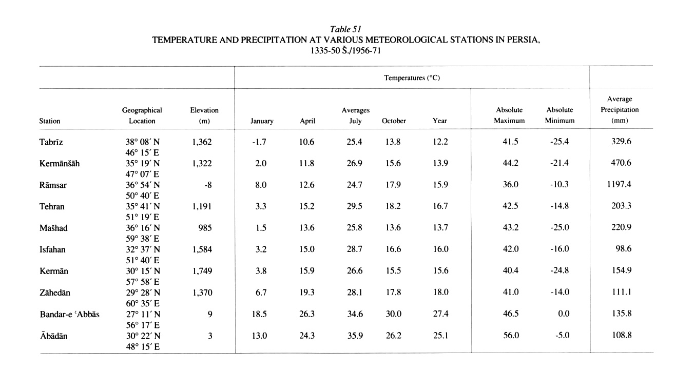
An attempt to plot the average temperatures for the entire country reveals a general increase from northwest to southeast reflecting both the respective geographical positions and the elevations of the different regions (see Table 51). Whereas most of Azarbaijan is characterized by average annual temperatures of about 10° C, the average annual temperature on the Persian plateau is between 15 and 20° C. The entire Persian Gulf coast area, on the other hand, registers an annual average of more than 25° C; the highest annual average, about 30° C, occurs in southeastern Persia (station: Īrānšahr). In many respects average monthly temperatures and the annual extremes are much more significant than annual averages, especially in determining land use. The climate on the plateau is characterized by hot summers and extremely cold winters, with resulting broad ranges between the annual maximum and minimum temperatures, 20° C or more at many upland stations (e.g., Tabrīz, -1.7° C in January, 25.4° C in July). Indeed, the annual temperature range can be as much as 50-60° C, with winter lows of -25° C or less and summer highs of more than 40° C, often lasting as long as a day or even a week in certain enclosed stream basins in the mountainous border areas of the north and west. In winter Azarbaijan (stations: Tabrīz, Ḵᵛoy, Mīāndoāb) and the central Zagros (station: Šahr-e Kord) thus constitute the arctic poles of Persia. In the summer months the whole country is extremely hot; in July, the hottest month, temperatures average above 26° C. In the Caspian lowlands (station: Rāmsar) the July average is generally lower than in the continental highlands, but that is owing to the extreme humidity of the sultry neighboring regions. Most of the Persian Gulf coast experiences a similar pattern. For example, the two Persian Gulf stations at Bandar-e ʿAbbās and Ābādān report average July temperatures of about 35° C, added to which the permanent flow of moist sea air produces such high humidity that the inhabitants of the coastal areas leave their homes whenever possible and withdraw to cooler mountain regions for the summer months. The same is true of large parts of the Caspian lowlands, the periphery of the Dašt-e Lūt, Baluchistan, and the area around Jāz Mūrīān in Kermān, which are the hottest parts of the country in summer.
Persia can be divided into precipitation zones that correspond to the temperature zones (see bārān): The west, northwest, and north are particularly favored, both in annual averages and in seasonal distribution of precipitation, whereas that part of the plateau that is situated in the rain shadow of the neighboring mountains is markedly less so. It is clear that in Persia high average rainfall is recorded precisely at those points where moisture-laden winds or air masses strike the mountain ranges or single high peaks and are forced to give up much of their moisture; the northern flanks and foothills of the Alborz and the western slopes of the Zagros are thus the best-watered regions in the country.
The area that receives by far the most precipitation is the southern Caspian lowland. The extremely humid winds off the sea strike the northern flanks of the Alborz and Ṭāleš mountains and lose most of their moisture. In view of the prevailing northeasterly direction of the tradewinds the southwestern portion of this region, that is, the heartland of Gīlān province and Ṭāleš, enjoy the highest total precipitation in Persia. Anzalī (Bandar-e Pahlavī) receives an annual average rainfall of nearly 2,000 mm, whereas Rašt, which lies only about 30 km inland, receives 200-300 mm less. Farther east precipitation diminishes, reflecting the lower moisture content of the air masses that blow southeast across the Caspian: Bābolsar receives 807 mm and Gorgān only about 700 mm. In general the immediate coastal areas and the lower mountain slopes experience the highest rainfall. At elevations of about 2,000 m the moist air collides with the dryer winds of the plateau; the boundary is marked by a fairly stable level of condensation, which determines the ecology of the region.
The outer slopes and uplands of the Zagros, which experience winter westerly air flows and Mediterranean cyclones, are characterized by patterns of precipitation somewhat comparable to those on the northern flanks of the Alborz and in the southern Caspian lowland. These winds produce late-autumn and winter precipitation that contributes to annual averages of 500-600 mm. Nevertheless, differences in exposure play a much more important role than in the north. The western flanks of the mountains receive a great deal more precipitation than the eastern flanks and the valleys that lie in the rain shadow. Furthermore, precipitation continues to decline sharply from west to east; for example, although Kermānšāh, in the central Zagros, receives an annual average of 470 mm of precipitation, Isfahan, which lies about 300 km farther inland, on the eastern fringes of the range, receives less than 100 mm (see Table 51).
Differences in precipitation levels caused by relief and exposure are also important on the central Persian plateau, over most of which the annual average is less than 200 mm and often drops below 100 mm. On the other hand, those parts of the piedmont and the plateau that are encircled by mountain peaks are more fortunate in their ecology. There much of the precipitation falls in the form of winter snow (see BARF), which in the spring fills the streams with meltwater or raises the groundwater levels in the qanāts and can be used to water the newly planted fields. Snowfall thus has special importance in all the mountainous regions of northern and western Persia, the single largest area of the country where rainfall cultivation of winter cereals is practiced.
Finally, the seasonal distribution of precipitation reveals that, except for the southern Caspian lowlands, the hydrology of all parts of Persia is determined by the Mediterranean winter rains. The Persian plateau, the Zagros, and the Persian Gulf coast receive at least two-thirds, in some places up to 80 percent and more, of their annual precipitation in late winter and early spring. On the other hand, the southern Caspian lowlands, which receive heavy rainfall all year round, experience their maximum precipitation in the autumn. Everywhere in Persia summer is the season of lowest precipitation, whether measured in absolute or relative terms (see Table 52).
With the exception of the southern Caspian lowlands, the uplands of the Alborz and Zagros and the central Persian mountains on the plateau itself receive the most precipitation, most of which falls in the form of snow, providing gradually deepening permanent cover from Ābān/November, sometimes even Mehr/October, until Esfand/February-March.
Humidity and aridity. It is clear from the correspondence of temperature and precipitation levels that the humidity or aridity of the land is of special significance in Persia. By far the largest part of the country is characterized by extreme aridity, which can be defined as precipitation deficits. The land along the southern coast of the Caspian Sea, on the other hand, belongs to a humid zone, with surplus precipitation.
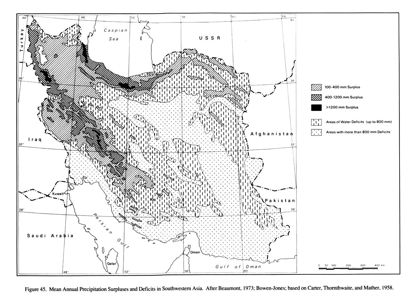
Several American climatologists have attempted to record and map the deficits and surpluses of precipitation over all of southwestern Asia. From Figure 45 it can be seen that the whole northwestern portion of that region, as well as the high Alborz and the Zagros ranges, belongs to zones of mean annual precipitation surplus. The close relation between relief and surplus precipitation can also be seen in the surpluses recorded in the smaller mountain ranges in Khorasan and central Persia, which are clearly exceptional in those regions. On the other hand, the periphery of the central Persian plateau and the Persian Gulf coast area suffer extreme precipitation deficits. The very large area over which deficits of more than 800 mm are recorded can be further differentiated on the basis of isolated measurements of evaporation; for example, in Ḵūzestān more than 2,660 mm have been recorded, and in the extremely dry Dašt-e Lūt the figure is more than 5,000 mm.
An attempt to define the climatic provinces of Persia. At present any attempt to divide Persia into different climatic provinces must be tentative and incomplete, in view of the great distances between observation stations, the varying time periods over which observations have been recorded, differences in the reliability of the data, and the still largely unexplored nature of the synoptic relationships. Nevertheless, in 1952 Bobek made such an attempt to differentiate Persia into climatic and ecological zones, based on an even more limited and incomplete body of published meteorological data than is now available, as well as on characteristic vegetation; the result was a detailed classification that is still valid today. He divided Persia into nine precipitation provinces, defined by the seasons of peak and secondary peak precipitation (1952, fig. 2):
1. Colchian-Caspian type: autumn and winter
2. Azarbaijan type: autumn and spring
3. Eastern Caucasian type: autumn and summer or summer and autumn
4. Central Caucasian-Greater Armenian type: summer and spring
5. Eastern Anatolian-Transcaucasian type: spring and summer
6. Kurdish-Khorasan type: spring and winter
7. Persian-Assyrian type: winter and spring
8. Persian Gulf coast type: winter
9. Baluchistan type: winter and summer
Bobek’s classification of the Persian climate according to zones of elevation defined by natural and cultivated vegetation has proved itself of even more lasting value. Taking into consideration terms from the colloquial language, he differentiated four such zones of elevation (pp. 74-75), relying primarily on thermal differences:
1. Subtropical plateau region (sarḥadd), with very cold winters and cool summers, above the tree line and the zone of cereals cultivation
2. Subtropical temperate region (sardsīr), with very cold winters and hot summers; cultivation of cereals and fruits typical of the temperate zone
3. Middle subtropical region
a. With winter cold, summer heat, and brief frosts; cultivation of pomegranates and many other subtropical and temperate-zone fruits
b. With mild winters, hot summers, and occasional frosts; cultivation of the same fruits as in 3a, along with some marginal date-palm plantations and citrus fruits
4. Subtropical lowlands (garmsīr), with warm winters, hot summers, and no frost or snow; primary cultivation of dates and tropical plants, as well as those grown in zone 3
These main climatic and ecological divisions, defined by a combination of thermal and hygrological data, are valid for the entire Persian plateau. On the outer flanks of the Zagros and the Alborz, however, as well as in parts of Azarbaijan, variations in relief and exposure introduce other considerations, which are reflected particularly in differences in natural vegetation.
Bibliography
A. H. Adle, Régions climatiques et végétation de l’Iran, Tehran, 1960.
P. Beaumont, “Qanat systems in Iran,” Bulletin of the International Association of Scientific Hydrology 16, 1973, pp. 39-50.
Idem, River Regimes in Iran, University of Durham, Department of Geography, Occasional Publication, N.S. 1, Durham, 1973.
Idem, “A Traditional Method of Ground Water Extraction in the Middle East,” Ground Water 11, 1973, pp. 23-30.
H. Bobek, “Beiträge zur klimaökologischen Gliederung Irans,” Erdkunde 6, 1952, pp. 65-84.
Idem, “Klima und Landschaft Irans in vor- und frühgeschichtlicher Zeit,” Geographische Jahresberichte aus Österreich 25, 1955, pp. 1-42.
H. Bowen-Jones, “Agriculture,” in Camb. Hist. Iran I, pp. 565-98.
K. W. Butzer, Quaternary Stratigraphy and Climate in the Near East, Bonner Geographische Abhandlungen 24, Bonn, 1958.
D. B. Carter, C. W. Thornthwaite, and J. R. Mather, Three Water Balance Maps of Southwest Asia, Laboratory of Climatology, Publications in Climatology 11/1, Centerton, N.J., 1958.
E. Ehlers, Iran. Grundzüge einer geographischen Landeskunde, Wissenschaftliche Länderkunde 18, Darmstadt, 1980, esp. chap. II/2.
M.-Ḥ. Ganjī (M. H. Ganji), “Climates of Iran,” Bulletin de la Société de géographie de l’Egypte 28, Cairo, 1955, pp. 195-299.
Idem, Āmār-e bārandagī dar Īrān/Iranian Rainfall Data, University of Tehran Arid Zone Research Center 3, Tehran, 1338 Š./1959.
Idem, “Climate,” in Camb. Hist. Iran I, pp. 212-49.
W. Köppen, Klimate der Erde. Grundriss der Klimakunde, Berlin, 1931.
A. Mostawfī et al., eds., Aṭlas-e eqlīmī-e Īrān/Climatic Atlas of Iran, Tehran, 1344 Š./1965.
Ḥ. Ṯābetī (H. Sabeti), Barrasī-e aqālīm-e ḥayātī-e Īrān/Les études bioclimatiques de l’Iran, Tehran, 1348 Š./1969.
C. Troll and K. H. Paffen, “Karte der Jahreszeitenklimate der Erde,” Erdkunde 18, 1964, pp. 5-24.
Figure 45. Mean Annual Precipitation Surpluses and Deficits in Southwestern Asia. After Beaumont, 1973; Bowen-Jones; based on Carter, Thornthwaite, and Mather, 1958.
Table 51. Temperature and Precipitation at Various Meteorological Stations in Persia, 1335-50 Š./1956-71.
Table 52. Annual Precipitation and Seasonal Distribution of Precipitation at Various Meteorological Stations 1335-50 Š./1956-71.