

ŠARAFĀBĀD, the name of a village and an adjacent ancient settlement called Tepe Šarafābād in Southwest Iran (FIGURE 1).
Geographical and ecological setting. The modern village Šarafābād, which was destroyed during the 1980s, was located 12 km south-southwest of Dezful in Khuzistan Province in an intensely cultivated area. The traditional village, located several hundred meters north of the Tepe Šarafābād, was marked by a large orchard surrounded by mud walls five meters high, inside which grew such trees as date palm, jujube, citrus, poplar, and willow. About 20 percent of the cropland in this area was devoted to such orchards (Nederlandsche Heidemaatchappij, pp. VI-3; Adamec, ed., p. 667). The remainder of cropland around the site was devoted to annual irrigated crops such as rice, broadbeans, barley, and wheat in a complex rotation. After each field was harvested, the land was normally used for grazing animals, mostly herds of sheep and goat, cattle, or water buffalo. The Dez River (Āb-e Dez), one kilometer to the west, was the source of irrigation water. Most of the land in the vicinity was owned by small landowners (Poyck, p. 24).
Tepe Šarāfabād (Khuzistan Survey [KS]-36; approx. N 32°16’58” and E 48°21’59”) is situated in the north-central sector of the Susiana plain of Khuzistan in southwest Iran. It is located 15 km northeast of Susa. It covers an area of about two hectares and rises about 11 meters above the modern plain. Before beginning the excavations, a controlled sample of surface material was collected. These collections indicated that the site was occupied relatively continuously from roughly 6000 BCE until 2800 BCE, reoccupied for a few centuries between 1900 and 1300 BCE, and then abandoned with no subsequent occupation.
Archaeological excavations. Tepe Šarāfabād was excavated in 1971 by the joint project of the University of Michigan and what was then the Archeological Service of Iran. The staff of the excavation was directed by Henry T. Wright III, and the official representative of the National Research Center for Archeology was Muhammed H.Ḵošābi. The site was chosen because initial surface surveys by Robert McCormick Adams and Frank Hole had suggested that site was important in rural production and transport during Uruk times, the period of early state development. Extensive (deep and well preserved) remains of the Elamite period were unexpected.
Stratigraphy and other cultural deposits. Study of the surface collections showed a high concentration of Elamite and Uruk material (more than two Elamite diagnostic sherds per square meter) in a band about 20 m. wide and at least 70 m. long, stretching across the saddle-shaped summit of the mound. Excavations in adjacent squares to the north (in the saddle where Elamite ceramics occurred) revealed deep Elamite deposits terraced into the Uruk deposits.
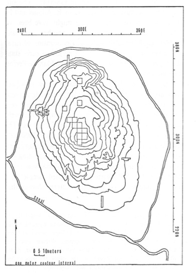
Next, a series of test trenches one meter wide were excavated on the north, south, east, and west sides of the mound to further test the limits of occupation during the various periods (Figure 1). Only the west trench encountered Elamite deposits, which consisted of several pits. This trench also encountered several in situ Uruk deposits that were explored by expanding the area of the trench. The east trench also encountered Uruk material that was subsequently shown to be a pit of that date more than four meter deep. Work in the north and south trenches was halted when it became apparent that they contained deposits only of pre-Uruk date(Wright et al., 1980 and 1989).
During the course of the excavations, several geological test pits were excavated near the mound. These pits were placed close enough to the mound so that soil horizons could be dated by sherds washed down from the mound, yet so far from the mound that no architectural remains would be encountered. The results from these geological tests showed that at least four meter of sediment had accumulated since the Uruk occupation of the area.
Prehistoric occupations. Surface collections contain ceramics of Early and Middle Susiana Periods extrusive from yet unexcavated earlier layers in the mound. Excavations showed that, by the end of the prehistoric period, the mound was at least fifteen meter above the plain level at the end of the Susiana period, ca. 4150 BCE. Substantial mud brick construction was revealed on the highest part of the mound, dating to the Late Susiana Period (the Susiana d and Susa A phases, ca. 4200 BCE). From this highest point, the mound crest slopes gradually to the north. At the north end of the crest, modest walls of domestic construction, also dating to Late Susiana Period, were found. Elamite villagers later terraced into the Uruk and latest Susiana deposits between these two areas, cutting them away and isolating these two remnants (Schacht, 1975).
Proto-historic occupations. The southern-most 5 by 5 m. test excavation on the summit immediately encountered three phases of modest domestic construction during the Early and Middle Uruk phases, demonstrating that by 3,400 BCE, the full height of the mound, 15 m. above Uruk plain level, had been reached. The East excavation encountered Middle Uruk pitcontaining debris revealed by analysis to have been deposited in two successive years, the first year bountiful and the second poor, with many sealings indicating both local administration and relations with the major centers. The West excavation revealed a midden and walls of the Middle Uruk period (Wright et al. 1980; idem, 1989). Late Uruk and Proto-Elamite sherds occurred in disturbed surface deposits.
Elamite occupation. There were four substantial Elamite building phases, and pottery showing numerous similarities to sites in the surrounding region dating to the Sukkalmah and Earlier Middle Elamite or Transitional periods (ca. 1900-1300 BCE). Other artifacts include two cuneiform inscriptions (Schacht, 1975, p. 325). One was a steatite cylinder seal in the same format as some from nearby Susa, including names attested in contemporary documents from Susa. The other was a fragment of a tablet in Old Babylonian that seems to mention “…my fields…” (details in Schacht, 1975, p. 326).
Historical context and significance. Archeological surveys have shown that the population of the Susiana Plain grew to unprecedented levels during the second millennium BCE. During the Sukkalamah phase, the number of known settlements on the plain doubled, and Susa, the regional capital, grew by 30 hectares (Schacht, 1987, pp. 177-79). Tepe Šarāfabād was one of the settlements founded during this Sukkalmah-phase expansion. Many of the documents from Susa during this period seem to be land contracts of some kind (Scheil 1930, 1932, 1933, 1939), although the scope of the lands involved has never been clear. However, there seems to be sufficient evidence to suggest the hypothesis that a general rise in regional population, especially in Susa, created a demand for agricultural products that may have assisted the process of transforming rural agricultural communities on the Susiana plain, such as Tepe Šarāfabād, into rural estates organized to export agricultural products to regional centers (cf. Schacht, 1973, pp. 110-11). It is also possible that one such estate, located at Tepe Šarāfabād, was owned by a landlord with ties to Susa or another center of the Elamite state (Schacht, 1987, p. 181).
Bibliography:
Ludwig W. Adamec, ed. Historical and Political Gazetter of Iran III: Abadan and Southwest Iran, Graz, 1989.
Robert McCormick Adams, “Agriculture and Urban Life in Early South Western Iran,” Science, no. 136, 1962, pp. 109-22.
Frank Hole, “The Origin of Agriculture in South Western Asia,” New Scientist 13, 1962, pp. 577-79.
Nederlandsche Heidemaatchappij, Report on the Dez Irrigation Project, Arnhem, Netherlands, 1958.
A. P. G. Poyck, Farm Studies in Iraq: An Agro-Economic Study of the Agriculture in the Hilla-Diwaniya Area in Iraq, Mededelingen van de Landbouwhogeschool te Wageningen 62/1, Nederland Wageningen, 1962.
Robert M. Schacht, “Population and Economic Organization in Early Historic Southwest Iran,” Ph.D. Diss., University of Michigan, 1973.
Idem, “A Preliminary Report on the Excavations at Tepe Sharafabad, 1971,” Journal of Field Archaeology 2, 1975, pp. 307-29.
Idem, “Early Historic Cultures,” in Frank hole, ed., The Archaeology of Western Iran: Settlement and Society from Prehistory to the Islamic Conquest, Washington, D.C., 1987.
Vincent Scheil, Actes Juridiques Susiens, Mémoires de la Mission archéologique en Perse 22, Paris, 1930.
Idem, Actes Juridiques Susiens (suite: nᵒ 166 à nᵒ 327), Mémoires de la Mission archéologique en Perse 23, Paris, 1932.
Idem, Actes Juridiques Susiens (suite: nᵒ 328 à nᵒ 395) Mémoires de la Mission archéologique en Perse 24 Paris, 1933.
Idem, Actes Mélanges épigraphiques, Mémoires de la Mission archéologique en Perse 28, 1939.
H. T. Wright, N. F. Miller, and R. W. Redding, “Time and Process in an Uruk Rural Center,” in M. T. Barrelet, ed., L’Archéologie de L’Iraq, Paris, 1980, pp. 265-84.
H. T. Wright, R. W. Redding and S. M. Pollock, “Monitoring Inter-annual Variability: An Example from the Period of Early State Development in Southwestern Iran,” in John M. O’Shea and Paul Halstead, eds., Bad Year Economics: Cultural Responses to Risk and Uncertainty, Cambridge, 1989, pp 106-13.
(Robert M. Schacht and Henry T. Wright III)
Originally Published: October 22, 2010
Last Updated: October 22, 2010