


KOJUR
i. Historical Geography
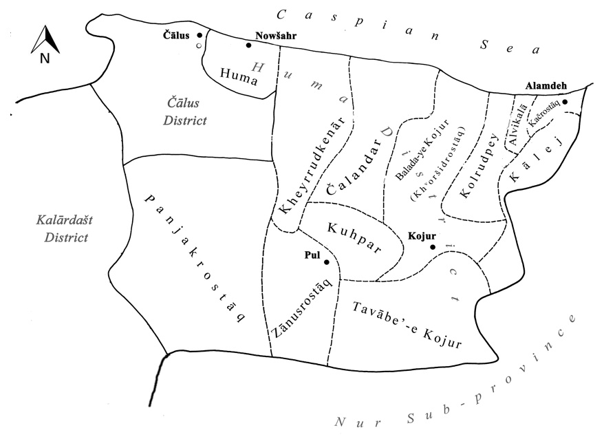
Topography. The historical district of Kojur covers roughly a quadrangle (about 55 km by 40 km) bounded by the Caspian Sea on the north, the Čālus River on the west, Nur valley on the south, and Suledeh valley on the east. Its exact contours have always been a subject for debate owing to recurrent renaming, administrative changes, and inaccurate cartography. A close scrutiny of historical sources points to the following constituent parts: (1) The core of Kojur consists of the surroundings of the river Pul (also called Kojur), which rises from the main Alborz massif and flows west-northwest for some 40 km before it joins the Čālus River. This secluded basin is bounded on three sides by offshoots of the Alborz range: on the south stands the great Varavašt as its highest peak (4,008 m) within the Nur ridge, on the dry southern face of which lies the Nur district; on the north, a low, lateral chain separates the Pul valley from the Caspian coastline; and on the east lies Qalʿa Gardan with its highest point at 2,623 m. (2) Across the latter mountain runs an out-of-the-way high valley, which also bears the name of Kojur, with a river (not to be mistaken with the abovementioned Pul/Kojur river) running some 35 km longitudinally into the Caspian Sea. (3) Some 15 km further east runs the parallel valley of Galandrud, which opens onto the littoral plain some 5 km before reaching the Caspian Sea. (4) North of the mountainous interior mentioned above, there is an associated coastal area, which stretches some 50 km along the Caspian seashore, from the Čālus River to Alamdeh (renamed Ruyān in the 1990s) and Suledeh/Suldeh (presently, Nur city). In the coastal area the mountains advance toward the coastline, leaving a very narrow littoral plain, less than 3 km wide for the most part, which is crossed by several northward-flowing streams other than the Kojur and Galandrud rivers mentioned above.
Given the wide range of elevations in Kojur, two climatic regions can be noted. The highlands or yeylāq (the common term in Persian for the high altitude and relatively cool summer pastures and resorts) are covered with thin forest of trees and shrubs (see FORESTS), with human settlements scattered along streams; Kojur and Pul villages are the largest. In contrast, the warm, humid littoral lowlands (qešlāq) are covered with trees, mostly box, sour pomegranates, sour plums, acacias, medlars, jasmine, and wild apples figs (Noel, p. 411; Rabino, 1913, p. 444). The littoral part of Kojur is densely populated in the form of close-knit agricultural settlements, with only a wedge-shaped area—of some 6 km2 (measured from Google Earth), at the mouth of the Kojur river—of the original forest preserved as the Sisangān National Park.
Economy and administration. Until lately, the economy remained entirely rural in the highlands. The alluvial river valleys provided ideal ground for grain cultivation, mostly rain-fed, to the extent that John Baptist Lucius Noel (1890-1989) called Kojur and Pul, together with Kalār, the granary of the Caspian provinces (Noel, p. 411). Rice plantations dominated in the northern plains (for details, see MAI, 1969, pp. 56-65). During winter, most of the workingmen of the mountainous settlements would seek work in Tehran or in the plain of Māzandarān. A lucrative business was turning wood into charcoal, an undertaking that was curtailed by the nationalization of forests in 1963. The traditional economy of Kojur was supplemented by animal husbandry in foothill pastures. Sheepherders, called nāij in the local dialect, spent half of the year in the high uplands and the rest in villages, where women ran the economy (on the rural economy of a typical mountainous village, see Purkarim, 1970a, 1970b).
Commensurate with its rural economy, the population in the pre-modern period lived exclusively in villages. The district’s center, Kojur (lat 36°23′ N, long 51°44′ E), at 1,490 m above sea level, had a population that grew from 156 souls in the 1940s (Razmārā, pp. 227-28) to 1,116 in 1966 (MAI, 1969, pp. 56-65). Other large settlements were Pul (lat 36°23.5′ N, long 51°35.5′ E) with 1,617 souls and, by the Caspian coast, Alamdeh (lat 36°34′ N, long 51°57.5′ E) with 1,620 inhabitants (ibid.). Ḥabibābād, a modest villages of 65 houses in Rabino’s time, having expanded rapidly since the mid-20th century to become the port of Nowšahr, is now the administrative center of what used to be Kojur. The opening of the Tehran-Čālus highway in 1938 made Kojur’s highland region, celebrated for its pleasant climate, easily accessible to the ever-growing population of Tehran. As a result, summer villas have increasingly been replacing the rustic architecture of Kojur, and Kandelus in the Miḵsāz valley has become a particularly popular location and tourist site.
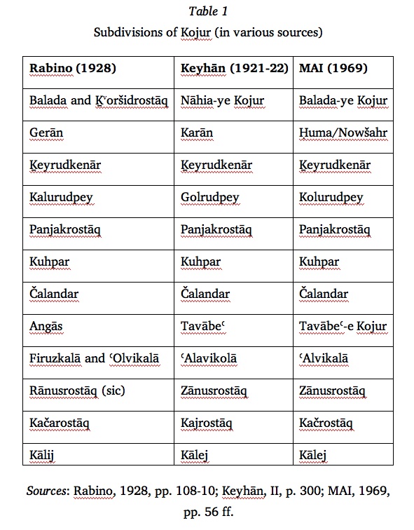
Administratively, the district of Kojur has seen several revisions both internally and externally within Māzandarān’s provincial subdivisions. In the late Qajar and early Pahlavi period, Kojur was administratively part of Tonekābon. The reorganization under Reza Shah made Kojur one of the ten subdivisions constituting Māzandarān Province (Keyhān, II, pp. 284). In the 1940s, Kojur was consolidated into the newly established Nowšahr Sub-province (šahrestān) (Razmārā, pp. 309-10), and it was further demoted to the rank of two rural districts (dehestān), named Balada-ye Kojur and Tavābeʿ-e Kojur. Subsequently, historical Kojur corresponds roughly to the Ḥuma and Markazi districts (baḵš) of Nowšar Sub-province, circumscribed by Čālus and Kalārestāq to the west, Nur to the south, Suledeh/Nur to the east, and the Caspian Sea to the north (see map, Figure 1). Table 1 compares the subdivisions (boluks, later: dehestāns) listed in three sources (further, cf. Razmārā, p. 227; Moṣāḥeb, II, p. 2184). Hyacinthe Louis Rabino compiled his list of boluks and their constituent villages based on the official revenue list made available to him as well as his own fieldwork; his list includes, additionally, Bandpey and Zandrostāq (Rabino, 1928, pp. 108-10).
Roads. In the highlands, the main road of the district runs latitudinally from the confluence of the rivers Čālus and Pul to upper reaches of the Galandrud (via Marzanābād—Pul—Kojur—Kop), thence along the Galandrud northward to Alamdeh on the Caspian coast. This course seems to match the famous Safavid highway (built under ʿAbbās I), traversing the Caspian littoral but shifting inland from Kojur westwards. On the other hand, the modern Caspian causeway of Reza Shah’s reign passes along the coastal line of Kojur and has several modern bridges spanning the potentially flooding rivulets that flow into the Caspian. Within the Kojur highlands, a major road runs from the upper reaches of the Pul river north to the city of Nowšahr.
History. Kojur was historically an integral part a greater mountainous province that during the past millennium carried the names Ruyān, Rostamdār, Maḥāl-e Ṯalāṯ, and Tonekābon. Although the boundaries of this province varied with the coming and going of rulers and dynasties, it was always positioned within the Alborz highlands extending between the plains of Māzandarān and Gilān.
The central position of Kojur within Ruyān can perhaps be indirectly inferred from the references to the Caspian region in legendary accounts and traditions as depicted in the Šah-nāma and other extant medieval accounts. Although Kojur itself remains unmentioned, its rostāqs and villages play a central role during certain events related to the Irān-Turān wars. According to Ebn Esfandiār, the king Manučehr, fleeing from Afrāsiāb, took refuge in Rostamdār, first in Ḵvoršidrostāq (spelled also Kuršidrostāq, Gurešjerd, etc. in sources), then in Čalandar, where the mountains are nearest to the sea. Here, between the villages of Vanušadeh and Konos, he dug a great moat, behind which he maintained his army and sent his family to Muz village, near which he concealed his treasure (Rabino, 1928, p. 29). The same story, when relayed by Ẓahir-al-Din Marʿaši in his Tāriḵ-e Ṭabarestān, states that Manučehr took up his residence in Kuš, where he redirected the course of a river [Kojur River] to discharge into the sea at Sisangān, and built on the drained plain the town of Ruyān in the plain of Kojur (Rabino, 1928, p. 30).
The name Kojur appears in earlier sources as Kajja/Kačča and Kaču/Kaju(ya). Tenth-century geographers describe Kajja as the seat of the governor of Ruyān (bihā mustaqarr al-wālī wa hiya qaṣabatuhā; Ebn Rosta, p. 150; Ebn al-Faqih, p. 305). Four centuries later, Yāqut, evidently quoting the earlier geographers, states that Kačča was the capital (madina) of Ruyān and the seat of its wāli (Yāqut, II, p. 873, s.v. Ruyān), but mistakenly identifies Kajja with Kalār (idem, IV, p. 240, s.v. Kajja). The form Kajja must have fallen into disuse early on, as we find the new form Kaju/Koju on the gold coins minted in 504/1110-11 by the Baduspanid rulers Moḥammad b. Malekšāh and Naṣr b. Šahrivaš (Morton, nos. 8-11). Ebn Esfandiār (fl. early 13th century), the first of the three great historians of Māzandarān, also uses the spelling “Koju.” However, a century and a half later Awliāʾ-Allāh Āmoli regularly uses “Kojur,” as does Ẓahir-al-Din Marʿaši at the end of the 15th century. Notwithstanding the final-r sound development, the form Koju survived as an alternate spelling on coins at least to the end of the 16th century (Morton). The out-of-the-ordinary rhotacization of the toponym from Koju to Kojur may be explained as a phonological adjustment instigated by Kojur being repeatedly phrased together with its neighboring Nur district; that is, Nur o Kaju became Nur o Kojur in official documents, if not also among the local population. This conjecture is buttressed by the observation by Nimā Yušij, who was from Nur himself, that a local pronunciation of “Kojur” is K.ju, a word with the generic meaning maḥall, deh “village,” whence k.ju-var “village and its environs” (Nimā Yušij, p. 286). There is further evidence to the same effect in the current toponym of Kač-rostāq (cf. historical Kačča, Kaču) rural district in northeastern Kojur (Figure 1).
The correlation between the earlier Kajja and the later Kojur on the one hand and between these and the city of Ruyān on the other has been discussed by several scholars (Vasmer, 1927; idem, “Māzandarān”; Rabino, 1928, pp. 30, 154, n. 39; Le Strange, 1930, pp. 373-74; Stark, 1934; Minorsky, “Rūyān”). A persuasive argument to the effect that they all refer to the same location is brought up by Alexander H. Morton. He arrives at this deduction by exploring a principal source, an 8th-century register, preserved by Ebn Esfandiār, of garrisons (maslaḥa) established in various places in Ṭabarestān during the Arab conquest. Among the listed cities Kaju is defined as qaṣabat al-Ruyān, the chief city of Ruyān, which attracted a garrison of six thousand men, far larger than other towns of Ṭabarestān (Ebn Esfandiār, I, p. 180). Morton (p. 81) maintains that the list of garrisons, in its original form, must be earlier than the geographers’ references to Kajja; and, since Koju is attested as the most important town in Ruyān at such as early date, Kajja and Koju must be the same.
As stated above, Kojur began to be used as the name of a town. As late as the late 15th century, Ẓahir-al-Din Marʿaši conceives of Kočur as a city (šahr, balada) and/or fort (qalʿa, ḥeṣār) (Ẓahir-al-Din, Ṭabarestān, pp. 40, 44, 56, 57). It appears therefore that the toponym was extended from a town to a district at a later time. The Safavid historian Eskandar Beg Monši (p. 535) cites regularly, not only the Kojur fort (qalʿa), which was also known as Mārānkuh Qalʿa, but also Kojur district (welāyat). Kojur remained a significant district under the Qajars and early Pahlavis, as attested in travel accounts of Samuel Gottlieb Gmelin (d. 1774; tr., pp. 230 ff.; Fraser, p. 103; Wells; Fortescue, pp. 319 ff.; see also above).
The history of Kojur is inseparable from that of Ruyān and Rostamdār, which were ruled from the 11th to 16th century by Bāduspānids, the local rulers who carried the title of astandār. A major event specific to Kojur was, late in the Il-khanid era, the rebuilding of the town of Kojur and its fort during 1340-46 by the Bāduspānid Astandār Jalāl-al-Dawla Eskandar, who made Kojur his capital (Ẓahir-al-Din, Ṭabarestān, pp. 44-45). When, in the mid-15th century, the Bāduspānid territory was split between its two fraternal branches, Kojur (with Lārījān) first came under the control Banu Eskandar but was later (1504) captured by Banu Kāvus, who ruled from Nur. Thus Nur and Kojur began to be mentioned together, a tradition that continued in later sources. The long Bāduspānid rule was ended in the concluding years of the 16th century by ʿAbbās I (Eskandar Beg, pp. 534 ff.; tr., pp. 715 ff.). Under the Safavids, Kojur is often mentioned together with Nur as one administrative unit (e.g., Eskandar Beg, pp. 399, 521, 534; tr., pp. 576, 696, 713). Later, on the other hand, under the Qajar rule, Kojur, together with the neighboring Kalārestāq and, further west, Tonekābon, were administrated together as Maḥāl-e Ṯalāṯ.
After the downfall of the Safavids, there was continuous unrest in the Caspian provinces. In order to establish security and reinforce the authority of the central power, a policy of massive resettlement of tribes of Kurdish origin in the province of Māzandarān and central Alborz was inaugurated by Nāder Shah and later taken up by Āqā Moḥammad Khan. Rabino reports that the already settled Caspian inhabitants of Kojur were supplemented with a smaller population of ʿAbd-al-Maleki and Ḵᵛājavand clans (Rabino, 1928, pp. 12, 30), with each ethnic group having its own governor (Rabino, 1913, pp. 441, 445). Likewise, Xavier de Planhol, in an ethnographic study conducted in the late 1950s, found fundamental contrasts between the original population, known as the gil, and the newly imported Kurdish population, known as the il. While the gil tilled the fields, the il were chiefly cattlemen. The gil had embraced the official Shiʿism, while the great majority of the Kurds adhered to the sect of Ahl-e Ḥaqq. The economic differentiation, coupled with religious distinction, explains the noticeable segregation of the two groups. The Kurdish populations were concentrated in the southern highlands of Panjakrostāq, Zānusrostāq, and Tavābeʿ-e Kojur. In the latter rural district the village Hazārḵāl (elev. 1,550 m) was reported as entirely Kurdish, while the major village Pul had a large Kurdish population who lived in separate quarters (Eʿtemād-al-Salṭana; Razmārā, s.v. “Pul”). In the Miḵzāz valley of Zānusrostāq the Kurdish villages were located at higher elevations (Jahāngiri, pp. 60-63).
Archaeology and monuments. The professional archaeology of Kojur is limited to the excavation of its prehistoric caves by Carleton S. Coon during 1949-51. Historical monuments are found abundantly in both highland and littoral plain Kojur. This is evident from the inventory compiled by Sotuda (pp. 167-241), although this work must be used with some caution, as some items lack original research. For the most part the architectural heritage of Kojur consists of mausoleums which have been venerated throughout the ages and therefore preserved. In the characteristic style of Caspian architecture, most mausoleums of Kojur are tomb-towers topped by a pyramidal dome with brick facades. This style can be exemplified by the emāmzāda Sayyed ʿAli Kiā in the costal district of Ḵeyrudkenār (Sotūda, p. 231). Conspicuous among highland structures is the mausoleum known as Ṭāher and Moṭahhar in Hazārḵāl village, 3 km south of Kojur. Its cubical structure supporting an octagonal dome is believed to have been built by the Bāduspānid Astandār Malek Kayumarṯ b. Bisotun b. Gostahm b. Ziār (d. 1453) and contain his own tomb. Depicted briefly by Ẓahir-al-Din Marʿaši (Tāriḵ-e Gilān o Deylamestān, pp. 296-97) in 1459, the shrine’s architecture was described in detail by Mirzā Ḥasan Khan Eʿtemād-al-Salṭana in 1303/1866 (apud Sotuda, pp. 187-97). A century later, Manučehr Sotuda found the interior of the burial chamber severely altered and some of its parts stolen (Sotuda, pp. 197-98).
Bibliography
Qāsem Aḥmadi-Lāšaki, Kojur-e Māzandarān. Lāšak: Nemunahā-yi az taḥawwol dar jawāmeʿ-e rustāyi-e Irān, Čālus, 1994.
Awliā-Allāh Āmoli, Tāriḵ-e Ruyān, ed. M. Sotuda, Tehran, 1969.
H. Bobek, “Die Landschaftsgestaltung des südkaspischen Küstentieflandes,” in
J. Engelhorns, ed., Länderdkundliche Forschung. Festschrift Norbert Krebs, Stuttgart, 1936, pp. 1-25.
Ebn al-Faqih Hamaḏāni, Moḵtaṣar Ketāb al-boldān, ed. M. J. de Goeje, Leiden, 1886.
Ebn Esfandiār, Tāriḵ-e Ṭabarestān, ed. ʿAbbās Eqbāl, Tehran, 1941; tr. (from manuscripts) Edward G. Browne as An abridged Translation of the History of Ṭabaristán, GMS 2, Leiden, 1905.
Ebn Rosta, Ketāb al-aʿlāq al-nafisa, ed. M. J. de Goeje, Leiden, 1892.
Eʿtemād-al-Saltana, al-Tadwin fi Ahwāl Jebāl Šarvin, Tehran, n.d.
L. S. Fortescue, Military Report on Tehran and Adjacent Provinces of North-Western Persia, Calcutta, 1922.
J. B. Fraser, Travels and Adventures in the Persian Provinces of the Southern Banks of the Caspian Sea, London, 1826.
Mollā Shaikh ʿAli Gilāni, Tāriḵ-e Māzandarān, ed. M. Sotuda, Tehran, 1976.
Samuel Gottlieb Gmelin, Reise durch Russland zur Untersuchung der drey Natur-Reiche, 4 vols., St. Petersburg, 1770-84; tr. in part by Willem Floor as Travels through Northern Persia, 1770-1774, Washington, DC, 2007.
ʿAli-Asḡar Jahāngiri, Kandelus, 2nd ed., Tehran, 1995.
Mohammad Ali Kazembeyki, Society, Politics and Economics in Māzandarān, Iran, 1848-1914, London, 2003.
Masʿud Keyhān, Joḡrāfiā-ye mofaṣṣal-e Irān, 3 vols., Tehran, 1921-22.
G. Le Strange, The lands of the Eastern Caliphate, 2nd ed., Cambridge, 1930.
MAI = Markaz-e āmār-e Irān (Sāzmān-e barnāma wa budj), Village Gazetteer/ Farhang-e ābādihā-ye kešvar XI. Ostān-e Māzandarān, Tehran, 1969.
Idem, Saršomāri-e ʿomumi-e nofus o maskan, 1385, Tehran, 2007.
V. Minorsky, “Rūyān,” in EI1: Encyclopaedia of Islam, First Edition (1913-1936), at Brill Online, 2013 (http://referenceworks.brillonline.com/entries/encyclopaedia-of-islam-1/ruyan-SIM_3735); in EI2 VIII, 1995, pp. 650-51.
Ḡolām-Ḥosayn Moṣāḥeb, Dāyerat al-maʿāref-e fārsi II/1, Tehran, 1977.
A. H. Morton, “Dinars from Western Māzandarān of Some Vassals of the Saljūq Sultan Muḥammad b. Malik- Shāh,” Iran 25, 1987, pp. 77-90.
Nimā Yušij, Yāddāšthā-ye ruzāna-ye Nimā: Bāznevisi o bāzyābi az ruy-e dastneveštahā-ye Nimā, ed. Šerāgim Yušij, 2nd ed., Tehran, 2009.
Nāṣer-al-Din Shah Qājār, Ruznāma-ye safar-e Māzandarān, lithographed edition, Tehran, 1977.
J. B. L. Noel, “A reconnaissance in the Caspian provinces of Persia,” Geographical Journal 57/6, 1921, pp. 401-15.
Xavier de Planhol, “Recherches sur la géographie humaine de l’Iran septentrional,” Mémoires et Documents du Centre de Documentation Cartographique et Géographique 9/4, 1964, pp. 3-79; Pers. tr. Sirus Sahāmi as “Pažuheš-i pirāmun-e joḡrafiā-ye ensāni-e šomāl-e Irān,” Majalla-ye dāneškada-ye adabiyāt o ʿolum-e ensāni-e Mašhad 6/1-3, 1970.
Hušang Purkarim, “Dehkada-ye Samā,” Honar o mardom no. 95, 1349 Š./1970a, pp. 31-44; no. 98, 1349 Š./1970b, pp. 45-56.
H. L. Rabino, “A Journey in Mazanderan (from Rasht to Sari),” Geographical Journal 42/5, 1913, pp. 435-54.
Idem, Mázandarán and Astarábád, London, 1928.
Ḥosayn-ʿAli Razmārā, ed., Farhang-e joḡrāfiāʾi-e Irān (ābādihā) III, Tehran, 1950.
Maḥmud Solṭāni-Largāni, Kojur, n.p., 2004.
M. Sotuda, Az Āstārā tā Astārbād III, Tehran, 1976.
F. Stark, “The Site of the City of Kalar in Kalar Dash,” Geographical Journal 83/3, 1934, pp. 211-17.
R. Vasmer, “Die Eroberung Ṭabaristāns durch die Araber,” Islamica 3/1, 1927, pp. 115-25.
Idem, “Māzandarān,” in EI1: Encyclopaedia of Islam, First Edition (1913-1936), at Brill Online, 2013 (http://referenceworks.brillonline.com/entries/encyclopaedia-of-islam-1/mazandaran-COM_0157).
H. L. Wells, “Across the Elburz Mountains to the Caspian Sea,” The Scottish Geographical Magazine 14, January 1898, pp. 1-9.
Šehāb-al-Din Abu ʿAbdallāh Yāqut Ḥamawi, Moʿjam al-boldān, 6 vols., ed. Ferdinand Wüstenfeld, Lepzig, 1866-70.
Mir Ẓahir-al-Din Marʿaši, Tāriḵ-e Ṭabarestān o Ruyān o Māzandarān, ed. M.-Ḥ. Tasbiḥi, Tehran, 1976.
Idem, Tāriḵ-e Gilān o Deylamestān, ed. H. L. Rabino, Rasht, 1912; ed. M. Sotuda, Tehran, 1985.