

JARQUYA
i. THE DISTRICT
The toponym is known locally also as Garkuya, with possible components gar and kuh (cf. Jarquh in Yāqut, II, p. 63), both meaning “mountain”; the first component may alternatively have derived from Av. gufra-, ǰafra- (deep), inferring also “lower,” in contradistinction to Abarquh “higher/upper mountain,” with which the adjoining district Jarquya has been linked throughout history.
Geography and economy. Separated from Isfahan by the Šāhkuh range, Jarquya spreads over 6,500 km², stretching in a northwest-southeast direction to the wasteland that separates it from Abarquh. The district is connected to Isfahan and Qomša by roads, but it is separated from Ardakān in Yazd Province by the Gāvḵuni lagoon, into which all Jarquya’s streambeds carry floodwater. Jarquya is extremely barren with less than 10 cm annual precipitation. Chronic drought and fuel consumption have resulted in destruction of much of the flora, save for a few stretches of steppes with gaz and ḡič (zygophyllum, bean caper; Šafiʿi, pp. 16-34). The lowland fauna, consisting of the deer, onager, and leopard, is extant only in the recollections of aged hunters. The Kolāh-qāzi heights in the northwest of the district is a protected park. Salt mines are exploited throughout the district, particularly in Siān, Rāmša, and Ḵārā (ʿĀbedi, p. 214).
Jarquya has been subjected to several modern administrative revisions. Traditionally ranked as a rural district (boluk) and occasionally grouped with Rudašt and Kuhpāya to its north, Jarquya is naturally and administratively divided into Upper and Lower Jarquya (Jarquya-ye ʿOlyā and Jarquya-ye Soflā, that is, farther and nearer to Isfahan, respectively), each with relatively stable oasis villages (Janāb, pp. 180, 191). Those of Lower Jarquya are Qārna, Ganjābād, Siān/Siun (or Siān-e Namaki, cf. the nearby Siān in Rudašt), Āḏarḵᵛārān (locally Ōḵāron; renamed Ḥabibābād after the Revolution of 1978-79), Ḥosaynābād, Moḥammadābād, Naṣrābād (former Givān), Yangābād (Yanguvā, now Nikābād), Peykān, Saʿādatābād, Mazraʿa-ʿArab, and Ḥaydarābād. Upper Jarquya consists of two clusters of villages: (1) Dastgerd, Kamālābād, Ḥasanābād (center), Ḵārā, Mālvājerd, and Yaḵčāl (renamed Allāhābād after the Revolution), and (2) Fayżābād, Esfandārān, Ḥāreṯābād, Aḥmadābād, Mobāraka, and Rāmša(n). None of these settlements distinguish themselves in terms of population or economy; hence, Jarquya’s administrative center has shifted several times in the modern era. The current seat is Nikābād (32° 18′ N, 52° 12′ E), located 65 km southeast of Isfahan and 1,565 m above sea level, with a population 4,800 (1990 estimate; see also ISFAHAN iii). The population of the district decreased from 30,300 in the early 1950s (Razmārā, p. 55) to nearly 27,900 in 1996 (Sāzmān-e barnāma, pp. 2, 6), in contrast to the high national growth. The main cause of depopulation has been migration to Isfahan and Tehran in search of jobs.
The district suffers from chronic water shortages. Its ninety subterranean channels (qanāt) have fallen into disrepair since the long period of drought which began in the mid-1960s. More than 200 deep and semi-deep wells have been dug ever since, providing saline water. The declining agriculture has partly been revitalized recently through the project of bringing the water of Zāyandarud River to Lower Jarquya by means of irrigation canals (104 km) via Mobāraka and the Mahyār plain. It is supplemented by 100 km of pipelines carrying drinking water by the rate of 100 liters per second (local interviews).
Rural economy prevails throughout Jarquya. The main produce is beans, beetroots, and fruits such as melons, pomegranates, figs, grapes, mulberry, almond, and pistachio; madder (ronnās) and some opium were also produced. The salinity of the water does not allow substantial production of various grains; only small amounts of cereals are sown. The industrial staple is cotton, renowned to be among the best produced in Persia (Eʿtemād-al-Salṭana, IV, p. 2186; Moḥammad-Mahdi, p. 320). The flourishing of textile industries in Isfahan in the early Pahlavi period (see ISFAHAN xiv) had an echo in Jarquya, where a cotton ginning mill was established, only to be relocated to Isfahan in the early 1950s (ʿĀbedi, p. 120). More recently, industrial spinning of the wool has been on the rise. Another thriving business in many villages is mechanized stockbreeding of poultry; a large storehouse in Nikābād supplies the poultry for the entire province (Šafiʿi, p. 415). Many families are engaged in truck transportation. Handicrafts include giva and cotton textiles such as jājim (a variety of flat-woven carpets), linen (karbās), and bed-sheets (čādor-šab), as well as carpets, all woven by women. Women would wrap themselves in white or colorful čādor-šabs in public while men used to dress richly in dark blue linen tunics (Šafiʿi, pp. 406; Mehryār, p. 48). They dress differently today; women wrap themselves in a loose, sleeveless black cover in compliance with government dress regulations, and men usually dress simply wearing jackets and plain shirts.
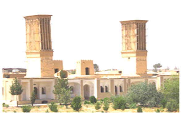
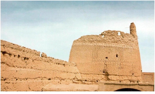
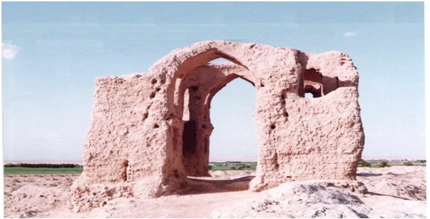
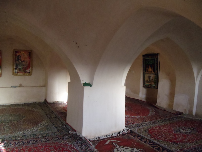
The older quarters of Yangābād and other major settlements have attractive desert architecture of vaulted constructions and outstanding wind towers (bādgir) and domes, all in sun-dried bricks marking the skyline. A few intact Qajar cisterns along the roads are reminiscent of more prosperous times. There are also remnants of mud-brick buildings, mostly fortifications and čahārtāq structures, belonging to the remote past (Šafiʿi, passim; cf. Afšār, p. 64). None of these have received serious archeological attention (See Figures 1, 2, 3, 4, 5, 6.). The landscape is also dotted with pigeon towers (borj-e kabutar), a typically common sight in the rural areas of Isfahan, which was once used for collecting pigeon manure to fertilize melon fields. A notable place in Jarquya is the shrine of Emāmzāda Shah ʿAbd-al-Moẓaffar, located at about 6 km west of Siān, where the festival of Šaṣt-šaši is held from the 66th to 70th days after Nowruz; an associated rite is swimming in a pond watered by Šāh Čašma, the outlet of the Siān’s spring. Some local pundits believe that this ritual is a remnant of the Tirgān or Ābpāšān festival. The same festival is held also in other Jarquya settlements, particularly in Mālvājerd and Rāmša (Mehryār, p. 415).
History. There are sporadic citations of individual places of Jarquya in the medieval sources. The castle of Qulanjān is described in the 13th and 14th centuries as a mud fortress at a two-day journey from Isfahan. It received its water from subterranean channels and its products were fruits, cereals, and grapes (Yāqut, II, p. 63; Mostawfi, I, pp. 123-24; Le Strange, p. 283). It is identified with the ruins of Quljān near Esfandārān (Janāb, p. 192; for the picture, see Šafiʿi, p. 73). In two decrees (one dated 971/1564) carved on the stone inscriptions in Isfahan’s Friday mosque, Mālvājerd is listed among the villages that were granted tax relief by Shah Ṭahmāsp I (r. 1524-76; Honarfar, pp. 89, 157). It appears that Jarquya had an old tradition of crafting weapons which thrived during the dynastic rivalry following the Afghan invasion (cf. Šafiʿi, p. 338, cf. preface by M.-E. Bāstāni Pārizi).
Droughts and disputes over allocation of water shape the modern history of the region. The drought of 1776-95 set Jarquya against the neighboring Qomša and Izadḵᵛāst (q.v.) for a share of the Izadḵᵛāst streams. As a result of the famine and feuds, Peykān and Yangābād were depopulated in favor of the newly-founded villages of Fayżābād, Mazraʿa-ʿArab, and Ḥaydarābād; the latter was named after the master digger of its subterranean channel (Šafiʿi, pp. 205-23). By Qajar times Yangābād and Peykān had regained their former importance, and Peykān had been designated as the administrative center (qaṣaba) of Jarquya (Širvāni, p. 199; Eʿtemād-al-Salṭana, IV, p. 2186).
An insurgency broke out in Jarquya over tax payment during the reign of Moḥammad Shah Qājār (r. 1834-48). The repetition of the rebellion in the summer of 1868 led to an invasion of the district by Isfahan’s prince-governor Masʿud Mirzā Ẓell-al-Solṭān, whose troops were defeated by Āqā Moḥammad Yangābādi. Only the severe famine and cholera of 1969-71 could break the local resistance. Later on, Āqā Moḥammad, much praised for his valor (Eʿtemād-al-Salṭana, IV, p. 2186), paid a conciliatory visit to the royal court in Tehran and was eventually appointed the governor of Jarquya and Abarquh (Šafiʿi, pp. 245, 228-57). His son and successor, Mollā ʿAli Khan Mirpanj, tried to evade the hostile people of Yangābād by moving his seat to the newly-founded village of Ganjābād, while his rival Mirzā ʿAbd-al-Ḥosayn Khan Mirpanj built the fortress of Raḥmatābād with a subterranean channel, a watermill, a cistern, and a bathhouse (Šafiʿi, pp. 264, 276).
The open terrain of Jarquya exposed it to nomadic incursions throughout its history. It is reported that Mālvājerd was depopulated following the Afghan invasion of Isfahan. The tribes from Fārs, who were relocated under the Zand dynastic rule, retain a semi-nomadic life near Naṣrābād and Moḥammadābād into this century (Šafiʿi, pp. 150, 415, 446; cf. Perry, pp. 210-11). The nomads belong to the clans of Bāṣeri, Lor, Sanjari, Visikusa, Moʾmeni, Jaʿfari, Dāstāni, and ʿArab, and some still use the Zagros uplands as their summer quarters (local interviews; Razmārā, pp. 55, 198). The occasional raids by the Baḵtiāri and Boir Aḥmadi tribal men extended into the years following World War II (Šafiʿi, pp. 134, 347).
There seems to have been a sizeable Zoroastrian community in Jarquya as recently as the late Qajar period. An early 20th century report alludes to the Pahlavi idiom (see ii below) as being spoken by the Zoroastrians of the area (Janāb, pp. 128, 247). There are still certain Muslim individuals and families who are referred to as gabr, the uncomplimentary term referring to Zoroastrians, which is also carried by a quarter in Esfandārān. In the old cemetery of Āḏarḵᵛārān, the Muslim grave-stones date no earlier than the 16th century, while the older stones, which bear no inscription, are attributed to Zoroastrians. Remnants of a fire temple still stand in Dastgerd (Šafiʿi, pp. 82-86, 180). In view of the existence of a fire temple and Zoroastrian communities in Jarquya, and the similarity of name Jarquya/Garkuya and Karkōk/Karkōy(a) in Sistān, where a famous fire temple stood (Tāriḵ-e Sistān, pp. 35-37; Markwart, pars. 35-37), drawing a historical connection between the two places appears plausible; nevertheless, from a comparative-historical perspective, it is difficult to relate the two toponyms, for the correspondence between the initial g and k is rarely found in Iranian languages.
Jarquya appears to have been integrated, against the will of its inhabitants, into Qomša administrative domain under Ẓell-al-Solṭān. It eventually succeeded to secede in 1955 after a decade of intensive, and at times violent, campaign, and to come under Isfahan’s jurisdiction (Šafiʿi, pp. 270, 358-65). There is an ongoing political campaign to promote the status of Jarquya from the current baḵš (district) to šahrestān (sub-provincial unit).
Bibliography:
Ḥasan ʿĀbedi, Eṣfahān az leḥāẓ,-e ejtemāʿi o eqteṣādi, Tehran? 1955.
Iraj Afšār, “Ḥalqa-ye Abarquya-Jarquya,” Zamān, no. 18, 1997, pp. 58-64.
Moḥammad-Ḥasan Khan Eʿtemād-al-Salṭana, Merʾāt al-boldān, ed. ʿAbd-al-Ḥosayn Navāʾi and Mirhāšem Moḥaddeṯ, 4 vols. Tehran, 1989.
Loṭf-Allāh Honarfar, Ganjina-ye āṯār-e tāriḵi-e Eṣfahān, Isfahan, 1965.
Mir Sayyed ʿAli Janāb, Eṣfahān, ed. ʿAbbās Naṣr, Isfahan, 1992.
Guy Le Strange, The Lands of the Eastern Caliphate, 2nd ed. Cambridge, 1930.
J. Markwart, A Catalogue of the Provincial Capitals of Eranshahr: Pahlavi Text, Version and Commentary, ed. G. Messina, Rome, 1931.
Moḥammad Mehryār, Farhang-e nāmhā wa ābādihā-ye kohan-e Eṣfahān, Isfahan, 2003.
Moḥammad-Mahdi b. Moḥammad-Reżā Eṣfahāni, Neṣf jehān fi taʿrif al-Eṣfahān, ed. Manučehr Sotuda, Tehran, 1961, 2nd ed., Tehran, 1989.
Ḥamd-Allāh Mostawfi Qazvini, Nozhat al-qolub, ed. and tr. Guy Le Strange as The Geographical Part of the Nuzhat-al-qulūb, 2 vols., Leiden and London, 1915-19.
John R. Perry, “Forced Migration in Iran during the Seventeenth and Eighteenth Centuries,” Iranian Studies 8/4, 1975, pp. 199-215.
Ḥosayn-ʿAli Razmārā, ed., Farhang-e joḡrāfiāʾi-e Irān (ābādihā) X, Tehran, 1950, repr. 1976.
Sirus Šafaqi, Joḡrāfiā-ye Eṣfahān, Isfahan, 1974.
ʿAli Šafiʿi Nikābādi, Garkuya: sarzamin-i nāšenāḵta bar karān-e kavir, 2nd ed., Isfahan, 1997.
Sāzmān-e barnāma wa budja, Markaz-e āmār-e Irān, Saršomāri-e ʿomumi-e nofus o maskan 1375, Šenās-nāma-ye ābādihā-ye kešvar, Ostān-e Esfahān, Šahrestān-e Esfahān, pub. no. 6-34, Tehran, 1997.
ʿAbd-al-Ḥosayn Sepantā, Tāriḵča-ye awqāf-e Eṣfahān, Isfahan, 1967, p. 44.
Zayn-al-ʿĀbedin Širvāni, Bostān al-siāḥa, lithograph ed., Tehran, 1898. Tāriḵ-e Sistān, ed. Moḥammad-Taqi Malek-al-Šoʿarāʾ Bahār, Tehran, ca. 1935.
Šehāb-al-Din Abu ʿAbd-Allāh Yāqut Ḥamawi, Moʿjam al-boldān, 5 vols., Beirut, 1955-57.
(Habib Borjian)
Originally Published: December 15, 2008
Last Updated: February 25, 2013
This article is available in print.
Vol. XIV, Fasc. 6, pp. 582-584
Habib Borjian, “JARQUYA i. The District,” Encyclopædia Iranica, online edition, 2013, available at http://www.iranicaonline.org/articles/jarquya-i-the-district-1 (accessed on 15 September 2015).