

HELMAND RIVER
i. GEOGRAPHY
At approximately 1,300 km (800 miles), the Helmand River is the longest river in Afghanistan. Originating from the Koh-e Bābā heights of the Hindu Kush (q.v.) mountain range (about 40 km west of Kabul), the Helmand receives five tributaries—Kajrud (Kudrud), Arḡandāb, Terin, Arḡastān, and Tarnak. Draining the entire southwestern portion of Afghanistan (approx. 100,000 sq. miles), the river moves southwest towards the Persian border, passing through the provinces of Wardak, Oruz-gān, Helmand, and Nimruz. South of Zaranj, the river flows northward, forming the Afghan-Persian border for 55 km before emptying into the Helmand (Sistān) marshlands. The river approaches the border area through the Mārgo Desert (Dašt-e Mārgo), and upon reaching it, splits into two separate waterways. The first, called Helmand (locally also called Daryā-ye Sistān, the Sistān River), flows through the Sistān plains, where it is used for irrigation by the local population. The second, named Siḵ-sar (also called Pariān), forms the Afghan-Persian border in the villages of Nāruʾi and Miānkangi and finally drains into the Hāmun-e Helmand, the main expanse of fresh water within the Iranian Plateau. In 1884 a flood widened the small channel branching off westward from the main course; and in 1886 another flood caused the Helmand to abandon its old course that ran close to Nād ʿAli and then into what was called the Siḵ-sar channel, transferring the bulk of its waters to the Pariān River, a channel further west which had previously been an artificial canal (Gazeteer of Afghanistan II, pp. 114-15; Fisher, p. 77; Dupree, p. 37; Jaʿfari, p. 483). Dams, distributaries, and protective embankments are some of the measures used to regulate such floods.
Irrigation canals are usually drawn from the river seven to fourteen miles above the land they irrigate (Gazeteer of Afghanistan II, p. 14; Jaʿfari, p. 483). The Helmand is navigable from Gerešk to the Sistān band, which is swept away during the annual flood season. The canals of Sistān below the Kuhak dam are unsuitable for navigation. Except in the three spring months, there is not enough water for heavy boats to navigate (Gazeteer of Afghanistan II, pp. 116-17).
The Helmand median annual water output is 2,200 million cubic meters and, although it runs its course mainly through Afghanistan, its most irrigable banks lie in Persia. “The Sistan country as well as the Garmsel or ‘warm track’ depend on the Helmand almost as much as Egypt does on the Nile” (Gazeteer of Afghanistan II, p. 119).
In the spring when the Hāmun lake reaches its maximum size, the water flows southward through the Selagrud River into the Gowd-e Zerreh depression in southwestern Afghanistan. Between May and October, the “Wind of 120 Days” (bād-e sad o bistroz; Fisher, p. 78; Dupree, p. 28), an erosive gale brought on by the differential pressures between the northern plains and the southern lowland deserts, blows from the northwest. This causes intense evaporation, which divides the Hāmun into three separate lakes: Hāmun-e Helmand proper, Hāmun-e Ṣā-beri, and Hāmun-e Puzak, the second lying partly, and the last entirely, within Afghan territory (Fisher, p. 78). Moreover, the silt laden Helmand can, if left unfettered, flow in various directions, and its history reveals that it can make sudden changes in its course and divert waters into new channels (McMahon, p. 10). However, despite the fact that the Helmand and its environs are naturally in flux, the late 19th and 20th centuries have witnessed a number of colonial and national schemes, including boundary commissions and large-scale irrigation projects, that have linked attempts to domesticate a wild river with the demarcation of the Afghanistan-Iran border (see iv. below).
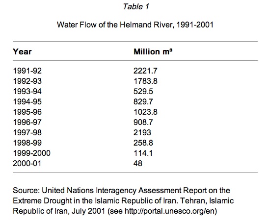
As Table 1 shows, the water flow of Helmand River has drastically declined from 2211.7 m3 million in 1991-92 to 1023.8 m3 million in 1995-96 to only 48m3 in 2000-2001. According to the same document “In recent years, the Helmand River has experienced dramatic declines in water flows. In 2001, the river ran at 98% below its annual average. With declining precipitation, the snowfields that supply the headwaters of the Helmand shrank from 41 000 km2 to 26 000 km2 between 1998 and 2000. With continued withdrawals for irrigated agriculture, Helmand waters failed to reach the Sistan basin altogether in 2001” (UNEP, 2003; see http://portal.unesco.org/en).
See also HĀMUN, DARYĀČA-YE.
Bibliography
Louis Dupree, Afghanistan, Princeton, 1973.
W. B. Fisher, “Physical Geography,” in Camb. Hist. Iran I, Cambridge, 1968, pp. 72, 78.
Gazeteer of Afghanistan II, pp. 114-27, 196-281.
ʿAbbās Jaʿfari, Gitāšenāsi-e Irān II: rudhā wa rud-nāmahā-ye Irān, Tehran, 1997.
A. H. McMahon, “Memorandum on the Seistan [Sistān] Water Question,” 1904, F. O. 60/728.
George Passman Tate, The Frontiers ofBaluchistan: Travels on the Border of Persia and Afghanistan, London, 1909.
Charles Edward Yate, Khurasan and Sistan, Edinburgh, 1900.