


i. HISTORICAL GEOGRAPHY OF HAZĀRAJĀT
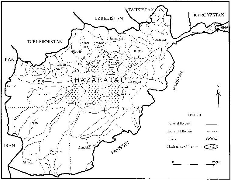
Hazārajāt, the homeland of the Hazāras, lies in the central highlands of Afghanistan, among the Kuh-e Bābā mountains and the western extremities of the Hindu Kush (q.v.). Its boundaries have historically been inexact and shifting, and in some respects Hazārajāt denotes an ethnic and religious zone rather than a geographical one–that of Afghanistan’s Turko-Mongol Shiʿites. Its physical boundaries, however, are roughly marked by the Bā-miān Basin (see BĀMIĀN ii.) to the north, the headwaters of the Helmand River (q.v.) to the south, Firuzkuh to the west, and the Salang Pass to the east. The regional terrain is very mountainous and extends to the Safid Kuh and the Siāh Kuh mountains, where the highest peaks are between 15,000 to 17,000 feet. Both sides of the Kuh-e Bābā range contain a succession of valleys. The north face of the range descends steeply, merging into low foothills and short semi-arid plains, while the south face stretches towards the Helmand Valley and the mountainous district of Besud (Fayż-Moḥammad, III; Thesiger, 1955, p. 313).
Figure 1. Map of Afghanistan with Hazāragi-speaking areas. Adapted from Mousavi, 1998, p. 68.
A series of mountain passes (kotal) extend along the eastern edge of the Hazārajāt, of which the Salang is blocked by snow for six months of the year or more, while the Šebar, at a lower elevation, is similarly snowed in for two months (Humlum, p. 64). In the spring and summer, the Kuh-e Bābā range accounts for some of Afghanistan’s greenest pastures. A number of the country’s rivers, including the Helmand, Harirud, Kābul, Morḡāb, and Panjao flow from the Hazārajāt (Mostawfi, tr. Le Strange, p. 212). Natural lakes and caves are also found in the Hazārajāt, many in the environs of Bāmiān (q.v.), and these sites have become the subject of legends and folktales told by the Hazāras about the geography and history of their homeland. In some cases, these natural landmarks are attributed to the works of ʿAli ebn Abi Ṭāleb (Mousavi, p. 71).
In Ferdowsi’s Šāh-nāma, the Hazārajāt is referred to as Barbarestān, an independent region in Turān. The Arab geographer Maqdesi knew the region as Ḡarj al-šahr–Ḡarj meaning “mountain” in the local dialect–an area ruled by chiefs. In the later Middle Ages the region was called Ḡarjestān, though the exact location of its main cities were still unknown (Le Strange, tr., 1919, pp. 415-16; see also Mousavi, p. 39). According to the 10th-century Persian geographical text Ḥodud al-ʿālam (ed. M. Sotuda, Tehran, 1961; q.v.), the area was “entirely mountainous” and its people were “herdsmen and farmers,” cultivating land, which was partly non-irrigated (lalmi) and partly irrigated (ābi; Ḥodud al-ʿālam, p. 105). The Hazārajāt was then considered part of the larger geographic region of Khurasan (Kušān), the porous boundaries of which encompassed the vast region between the Caspian Sea and the Oxus River (Āmu Daryā; q.v.), thus including much of what is today northern Iran and Afghanistan.
Northwestern Hazārajāt encompasses the district of Ḡor, long known for its mountain fortresses. The 10th-century geographer Estaḵri wrote that mountainous Ḡor was “the only region surrounded on all sides by Islamic territories and yet inhabited by infidels” (Barthold, p. 51). Ebn Ḥawqal described Ḡor as a mountainous country full of mines and running streams (Ebn Ḥawqal, tr. Kramers and Wiet, II, pp. 429-30). Ḡor’s rivers, cultivated fields, and pastures were praised by Edrisi, who surmised that the province’s boundaries were Herat, Juz-jān, Qarawāt, and Ḡarjestān (tr. Amedee Jaubert, p. 458). The long resistance of the inhabitants of Ḡor to the adoption of Islam provides an indication of the region’s inaccessibility; according to some travelers, the entire region is comparable to a fortress raised in the upper Central Asian highlands: from every approach, tall and steep mountains have to be traversed to reach there. The language of the inhabitants of Ḡor differed so much from that of the people of the plains, that communication between the two required interpreters (Barthold, p. 52).
The Bāmiān Basin, the northeastern part of the Hazāra-jāt, is the site of ancient Bāmiān, a center of Buddhism and a key caravanserai on the Silk Road. The town is situated at a height of 7,500 feet and surrounded by the Hindu Kush to the north and Kuh-e Bābā to the south. Ebn Ḥawqal referred to Bāmiān as “the cold part of Khurasan,” where winters are reportedly severe (Ebn Ḥawqal, p. 227). Bāmiān is famous for the two giant Buddhas carved into its sandstone cliffs, which stood at 165 and 114 feet tall, respectively, until they were destroyed by the Taliban in 2001. It was not until the rule of the Ghaznavid dynasty in the 11th century that Islam was established in Bāmiān, Ḡor, and the rest of the Hazārajāt. According to Ḥamd-Allāh Mostawfi, at the time of the Mongol invasions Prince Mutukin, the son of Jaghatay Khan, was killed during the siege of Bāmiān. To avenge his grandson’s death, “Chingiz Khan ordered Bāmiān and its people to be laid in ruins, renaming the place Mav Baliq (“Bad Town” in Mongolian) and commanding that no one should ever build or settle there” (tr. Le Strange, p. 152)
The subjugation of the Hazārajāt, the mountain fortresses of Ḡor in particular, proved difficult for the Mongols after their conquest of the region, and ultimately Mongol military detachments left behind in the region “adopted the language of the vanquished” (Barthold, p. 82). During the late 14th century, Timur’s armies made expeditions into the Hazārajāt, but after his death the Hazāras were once again free in their mountains (Ferrier, p. 221).
In the Mongol period, most Hazāras were pastoralists who lived in yurts and whose language was Moḡol. By the early sixteenth century however, they were living in fortified villages (qalaʿ), speaking a Persian dialect, and farming the land to produce their own grains in the high steppes. They continued to keep flocks however, and some Hazāras on the more arid northern slopes of the Kuh-e Bābā remained nomadic, migrating between yeilaq, or highland summer pastures, and qishlaq, or lowland winter pastures (Humlum, p. 87). It is probable that the Hazāras were mostly Sunnis who converted to Shiʿism in the Safavid era, though some have suggested that traces of Shiʿism in the region can be dated back to at least the Ilkhanid period. Most are Twelver Shiʿis, but there also exist Ismaʿili, Zaidi, and Sunni Hazāras (Mousavi, pp. 73-76).
In the 18th and 19th centuries, as a sense of “Afghan-ness” developed among the Sunnite Pashtuns, the Shiʿite Hazāra tribes began to cling together (Canfield, p. 3). Once the Ḡilzi (q.v.) Afghans became independent of the Safavids in the 1720s, Pashtun nomads (kuči, ilat) began to migrate into the pastures of Hazārajāt, pushing the Hazāras westward (Raverty, p. 35).
It has been suggested that in the nineteenth century there was an emerging awareness of ethnic and religious differences among the population of Kabul. This brought about divisions along “confessional lines” that became reflected in new “spatial boundaries” (Noelle, p. 22). During the reign of Dōst Moḥammad Khan (q.v.; r. 1242-55/1826-39, 1259-79/1842-63), Mir Yazdānbaḵš, a diligent chief of the Besud Hazāras, consolidated many of the Hazāra tribes and the districts they controlled. Mir Yazdānbaḵš collected revenues and safeguarded caravans (qāfela) traveling on the Ḥājigak route through Bā-miān to Kabul from Shaikh ʿAli and Besud bandits. The consolidation of the Hazārajāt thus increasingly made the region and its inhabitants a threat to the Durrani state based in Kabul (Masson, II, p. 296).
Until the late 19th century, the Hazārajāt remained independent and only the authority of local leaders, ḵāns or mirs, was obeyed (Barthold, pp. 82-83). Joseph Pierre Ferrier, a French author who supposedly traveled through the region in the mid-nineteenth century, described the inhabitants settled in the mountains near the rivers Balkh and Ḵolm in an orientalist vein, casting the Hazāras as savage criminals: “The Hazāra population is ungovernable, and has no occupation but pillage; they will pillage and pillage only, and plunder from camp to camp” (Ferrier, pp. 219-20). Subsequent British travelers doubted whether Ferrier had ever actually left Herat to venture into Afghanistan’s central mountains and have suggested that his accounts of the region were based on hearsay, especially since very few people dared then to enter the Hazārajāt; even Pashtun nomads would not take their flocks to graze there, and few caravans would pass through (Ferdinand,p. 18).
During the Second Anglo-Afghan War, Colonel T. H. Holdich of the Indian Survey Department referred to the Hazārajāt as “great unknown highlands” (Holdich, p. 41). And for the next few years, neither the Survey nor the Indian Intelligence Department succeeded in obtaining any trustworthy information on the routes between Herat and Kabul through the Hazārajāt (A. C. Yate, pp. 147-48). In fact, the region remained largely unmapped in the modern sense until the work of the Afghan Boundary Commission between 1884 and 1886. The Commission, which was set up following Russia’s annexation of the Tekke Turkman stronghold of Marv, was a joint Anglo-Russian effort to establish the northern borders of Afghanistan. The Commission was a massive traveling survey, consisting of thirteen hundred men and two thousand animals. It strained local economies and became very unpopular among the people of Khurasan.
Various members of the Afghan Boundary Commission were able to gather information that brought the geography of remote regions such as the Hazārajāt further under state surveillance. In November 1884, the Commission crossed over the Kuh-e Bābā Mountains by the Čašma Sabz Pass. General Peter Lumsden and Major C. E. Yate, who surveyed the tracts between Herat and the Oxus, visited the Qalaʿ-e Naw Hazāras in the Paropamisus mountain range, to the east of the Jamšidis of Kušk. Noting surviving evidence of terraced cultivation in times past, both described the northern Hazāras as semi-nomadic with large flocks of sheep and black cattle. They possessed an “inexhaustible supply of grass, the hills around being covered knee-deep with a luxuriant crop of pure rye” (C. E. Yate, p. 9). Yate noted clusters of kebetkas, or the summer dwellings of the Qalaʿ-e Naw Hazāras on the hillsides, and described “flocks and herds grazing in all directions” (C. E. Yate, pp. 7-8; see also Lumsden, pp. 562-63).
The travels of Captains P. J. Maitland and M. G. Talbot from Herat, through Obeh and Bāmīan, to Balkh, during the autumn and winter of 1885, explored the Hazār-ajāt proper. Maitland and Talbot found the entire length of the road between Herat and Bāmīan difficult to traverse. They reported that the valleys of the Hazārajāt were well-cultivated and noted “a constant stream of people migrating from the country around Kabul, on account of the scarcity in the Afghan capital” (“Captain Maitlands and Captain Talbot’s Journeys in Afghanistan,” p. 103). As a result of the expedition, parts of the Hazārajāt were “surveyed on one-eighth inch scale” and thus made to fit into the mapped order of modern nation-states (ibid., pp. 105-07; Anderson, pp. 170-78). More thought and attention was put into demarcating the definite borders of modern nations than ever before, which entailed great difficulties in frontier regions such as the Hazārajāt.
The geographical reach of the authority of the Afghan state was extended into the Hazārajāt during the reign of ʿAbd-al-Raḥmān Khan (1880-1901; see AFGHANISTAN X.). Caught between the strategic interests of foreign powers and disappointed by the demarcation of the Durand Line (1893) in southern Afghanistan, which cut into Pashtun territory, he set out to bring the northern peripheries of the country more firmly under his control. This policy had disastrous consequences for the Hazārajāt, whose inhabitants were singled out by ʿAbd-al-Raḥmān Khan’s regime as particularly troublesome: “The Hazāra people had been for centuries past the terror of the rulers of Kabul” (Munshi, ed., p. 276).
Later in the early 1890s, the tribes of the Hazārajāt were taxed and conscripted, while thousands were massacred. Pashtun nomads (kučis)were moved into the Hazārajāt, where they overran Hazāra farmlands and pastures (Mousavi, p. 95). Increasingly during summers, Pashtun nomads would camp in large numbers in the Hazārajāt highlands.
In the 1920s the ancient Šebar pass road which leads through Bāmiān and east to the Panjšir Valley was paved for lorries, and it remained the busiest road across the Hindu Kush until the building of the Salang tunnel in 1964 and the opening of a winter route. A paved road also has been built through the central mountains and the upper Harirud Valley to Herat (see further BĀMIĀN ii.). The Hazārajāt became increasingly depopulated as Hazāras migrated to cities and to surrounding countries, where they became laborers and undertook the hardest and lowest-paid work.
In 1979, there were reportedly one and a half million Hazāras in the Hazārajāt and Kabul (Rubin, p. 26). As the Afghan state weakened, uprisings broke out in the Hazārajāt, freeing the region from state rule for the first time since the death of Amir ʿAbd-al-Raḥmān. Under the inspiration of the Islamic Revolution, various Hazāra-Shiʿi resistance groups were formed in Iran, including Naṣr (Victory) and Sepāh-e Pāsdārān (Troops of the Revolutionary Guards), with some being “committed to the idea of a separate Hazāra national identity”(Rubin, pp. 186, 191, 223). During the war with the Soviets, most of the Hazārajāt was unoccupied and free of Soviet or state presence. The region became ruled once again by local leaders, or mirs, and a new stratum of young radical Shiʿi commanders. Economic conditions are reported to have improved in the Hazārajāt during the war, when Pashtun Kučisstopped grazing their flocks in Hazāra pastures and fields (Rubin, p. 246). In recent times under the regime of the Taliban, the Hazārajāt again came under siege, as ethnic and sectarian violence devastated the region. In the spring of 1997, a revolt broke out among Hazāras in Mazār-e Šarif who refused to be disarmed by the Taliban. In the subsequent fighting, 600 Taliban were killed as they tried to flee from the city (Rashid, p. 58). The following year, in retaliation, the Taliban instituted genocidal policies reminiscent of Amir ʿAbd-al-Raḥmān Khan’s time. In 1998, an estimated five to six thousand Hazāras were massacred, as the Taliban tried to “cleanse” the north of Shiʿites (Rashid, pp. 67-74). At that time, the Hazārajāt was a vernacular region that did not exist on the official map of Afghanistan; the area was divided between the administrative provinces of Bāmiān, Ḡor, Wardak, Ḡazni, Oruzgān, Juzjān, and Samangān, with the Hazāras being a minority in each (Rubin, p. 246).
Bibliography
Benedict Anderson, Imagined Communities, London, 1991 [1983], p. 170-78.
Anonymous, Ḥodud al-ʿālam, tr. Minorsky, London, 1937; reprinted, 1982.
Anon, “Captain Maitland’s and Captain Talbot’s Journeys in Afghanistan,” Proceedings of the Royal Geographical Society 9, 1887, pp. 102-7.
Elizabeth E. Bacon, “Inquiry into the History of the Hazāra of Afghanistan,” Southwestern Journal of Anthropology 7, 1951, pp. 230-54.
W. Barthold, An Historical Geography of Iran, Princeton, 1984.
Robert Byron, The Road to Oxiana, London, 1937.
H. W. Bellew, An Enquiry into the Ethnography of Afghanistan, London, 1891.
Alexander Burnes, Travels into Bokhara, 3 vols., London, 1834.
Idem, Cabool: A Personal Narrative of a Journey to, and Residence in that City in the Years 1836, ‘7, and ‘8, London, 1842.
Robert L. Canfield, Hazāra Integration into the Afghan Nation, New York, 1973.
Louis Dupree, Afghanistan, Princeton, 1973.
M. Elphinstone, An Account of the Kingdom of Caubul, 3 vols., London, 1815.
Klaus Ferdinand, Preliminary Notes on Hazāra Culture, Copenhagen, 1959.
J. P. Ferrier, Caravan Journeys and Wanderings in Persia, Afghanistan, Turkestan, and Beloochistan, London, 1856.
Ḥodud al-ʿālam, ed. M. Sotuda, Tehran, 1961.
T. H. Holdich, The Indian Borderland, 1880-1900, London, 1901.
Johannes Humlum, La geographie de l’Afghanistan, Copenhagen, 1959.
Ebn Ḥawqal, Ke-tāb ṣurat al-arż, trs. J. H. Kramers and G. Wiet as Configuration de la terre, 2 vols., Paris, 1964.
Abu ʿAbd-Allah Moḥammad Edrisi, Nozhat al-moštāq fi eḵterāq al-āfāq, tr. P. Amedee Jaubert as Geographie d’Edrisi, 2 vols., Paris, 1836-1840.
Fayż-Moḥammad, Serāj al-tawāriḵ, 3 vols., Kabul, 1912.
Mohan Lal, Travels in the Punjab, Afghanistan, and Turkestan, to Balkh, Bokhara, and Herat, London, 1846.
R. Leech, “A Vocabulary of the Language of the Moghal Aimaks,” JASB 7, 1838, pp. 785-87.
Guy Le Strange, The Lands of the Eastern Caliphate: Mesopotamia, Persia, and Central Asia from the Moslem Conquest to the time of Timur, Cambridge, 1905.
Peter Lumsden, “Countries and Tribes bordering on the Koh-e Bābā Range,” Proceedings of the Royal Geographical Society 7, 1885, pp. 561-83.
Idem, “A Supplementary Account of the Hazārahs,” JASB 14, 1845, pp. 333-40.
C. Masson, Narrative of Various Journeys in Baloochistan, Afghanistan, and the Punjab, 3 vols. London, 1842.
Robert McChesney, Kabul under Seige: Fayz Muhammad’s Account of the 1929 Uprising, Princeton, 1999.
S. A. Mousavi, The Hazāras of Afghanistan, London, 1998.
Mir Munshi, ed., The Life of Abdur Rahman, Amir of Afghanistan, 2 vols., London, 1900.
Ḥamd-Allāh Mostawfi, Nozhat al-qolub, tr. Guy Le Strange, London 1919.
Christine Noelle, State and Tribe in Nineteenth-Century Afghanistan, Richmond, 1997.
M. Afzal Orazgani, al-Moḵtaṣar al-manqul fi tāriḵ-e Hazāra wa Moḡol, Quetta, 1913.
Ahmed Rashid, Taliban: Militant Islam, Oil, and Fundamentalism in Central Asia, London and New Haven, 2000.
H. Raverty, Notes on Afghanistan and Parts of Baluchistan, London, 1888.
Barnett Rubin, The Fragmentation of Afghanistan, New Haven, 2002.
Freya Stark, The Minaret of Djam, London, 1970.
Wilfred Thesiger, “The Hazāras of Central Afghanistan,” The Geographical Journal 71/3, 1955, pp. 312-19.
Idem, “The Hazārajāt of Afghanistan,” The Geographical Magazine 29/2, 1956, pp. 87-95.
J. Wood, A Personal Narrative of a Journey to the source of the River Oxus, London, 1841.
A. C. Yate, Travels with the Afghan Boundary Commission, Edinburgh, 1887.
C. E. Yate, Northern Afghanistan, Edinburgh, 1888.
Yāqut, Moʿjam al-boldān, 5 vols., Beirut, 1955-57.