

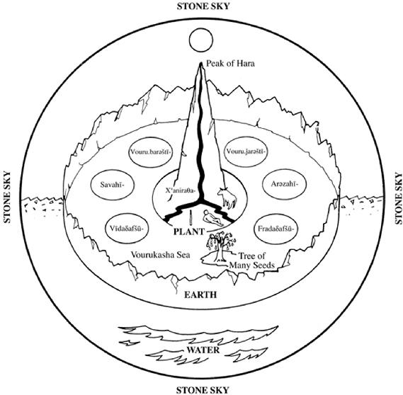
HAFT KEŠVAR (seven regions), the usual geographical division of the world in Iranian tradition. Ancient Iranians, who may have believed in a tripartite division of the earth (see IRAJ), developed an orderly picture of the world, envisioned as vast and round and encircled by a high mountain (harā bərəzaitī, see ALBORZ).
According to this tradition, the world was divided into seven (circular) regions (karšvar < karš- ‘to plough’; AirWb., cols. 458, 459, hence a tract of land bordered by a ploughed line, see Pur(-e) Dāwud, 1974, p. 111; Pah. and New Pers. kešvar,var. keškar; Manich. Parth. kišfar, see Mir. Man. III, p. 43). These were imagined as separated from one another by forests, mountains, or water, six flanking a central one called in Avesta Xvaniraθa- (MPers. Xwanirah, New Pers. Ḵoniras, Arabicized Honi-rat/Ḵonāras, probably Xvaniraθa- ‘self-made, not resting on anything else’, see Gershevitch, p. 176), which equaled in size all the rest combined and surpassed them in prosperity and fortune (Geiger, pp. 300-303; Boyce, Zoroastrianism I, pp. 133-34; Pur(-e) Dāwud, 1974, pp. 112-14). Originally only this continent was inhabited by man and the fabled home of the Aryans (Airyō.šayana-) was located there (Yt. 10. 13 with Bundahišn 14. 38, tr. Anklesaria, pp. 134-35), but the Čihrdād nask (q.v.) had described how men propagated and scattered into other regions and formed different races and rites (Dēnkard 8.13.2-3 with Christensen, 1917, pp. 13, 119). Sovereignty over all the seven regions was claimed by Iranian hero-kings (Yt. 19. 26, 28, 31; Bahrām son of Mardānšah, apud Ḥamza Eṣfahāni, pp. 23-25: Ṭabari, I, pp. 17, 170, 175, 179; for Sasanian period see Nāma-ye Tansar, p. 28; Šāh-nāma, ed. Moscow, VII, p. 164 v. 169, p. 172 v. 297, p. 180 v. 444). Hence, several expressions denoting “king of the seven regions” came to be used as synonyms for “king of Iran” (Bartholomae, pp. 19, 26; Widengren, p. 250; the notion permeates in Persian literature). The concept of the “seven regions” had Indo-Aryan roots (Geiger, pp. 302-3) and despite some claims (e.g., Herzfeld, pp. 684-85), was independent of Mesopotamian world view (Boyce, Zoroastrianism I, p. 134, n. 29), which pictured the earth as forming the middle level of the cosmos and consisting of a highly civilized core surrounded by four regions inhabited by savages with negative characteristics (Glassner, pp. 820-21).
The Iranian concept is alluded to in the Gāθās of Zoroaster (Y. 32.3, tr. Insler, p. 45) and fully attested in the Avestan hymn to Mithra (Yt. 10.12-16, 67), which describes the god as surveying at dawn the “whole Airyō.šayana-” and flying “over all regions (vīspāhu karšvōhu),” namely, Arəzahī- (Pahl. Arzah ‘east’), Fra-daδafšu- (Pahl. Fradadafš ‘southeast’), Vīdaδafšu- (Pahl. Wīdadafš ‘southwest’), Savahī- (Pahl. Sawah ‘west’), Vouru.barəštī- (Pahl. Wōrūbaršt ‘northwest’), Vouru.-ǰarəštī- (Pahl. Wōrūǰaršt ‘northeast’), and the splendid region of Xvaniraθa- (Xᵛaniraθa- bāmī-) in the center (Gershevitch, p. 81; for orientation see Henning, 1940, pp. 28-29 [repr. in idem, 1977, II, pp. 29-30]; contra Nyberg, pp. 400-401 and Schwartz, p. 643). The system influenced Zoroastrian eschatology (cf. Christensen, 1931, pp. 153-55). A spiritual leader watches over each region (Bundahišn. 29.1-4, tr. Anklesaria, p. 253), and the six comrades of Astvat.ərəta (q.v.) mentioned in Yt 19. 97, will, according to Dādestān ī Dēnīg (XXXV, 4-6) rise with him to fulfill his mission in the six regions surrounding the Xvaniraθa-. Remarkably, they bear names symmetrically corresponding with those of the six kešvars (Darmesteter, pp. 206-8; Boyce, Zoroastriansm I, p. 284). According to the Māh ī Fravardīn rōz ī Hordād (ed. and tr. Markwart, pp. 742-55, esp. p. 747), the hero Sām will rise again, kill Aži Dahāka (see AŽDAHĀ), and assume the rulership of the seven regions, but he will deliver it to Kay Ḵosrow, who shall rule for fifty-seven years and then will turn the sovereignty to Vištāspa.
Plate I. The world according to the Avesta.
The geographical knowledge of the Iranians greatly increased during the Achaemenid period, when the empire was divided administratively into twenty taxation districts (satrapies) and ethnically into some thirty nations (OPers. kāras). Yet, the notion of the seven-fold divi-sion of the earth influenced Persian ideology (Shahbazi, 1983, pp. 242-46 with undue overestimation). Darius the Great (q.v.) was thought to have divided his empire into seven parts and given them to the loyal colleagues who helped him recover the Persian throne (Plato, Epistel III, tr. Bury, pp. 501, 503); and an Aramaic document from Egypt dated in the reign of Darius II designating a district governor as hptḥpt’,from Iranian *haftaxʷapāta “protector of one-seventh,” shows that the division of a region into sevendistricts was a normal practice patterned after the Iranian cosmology of dividing the earth into seven kešvars (Henning, 1968, pp. 138, 143-44 [repr. in idem, 1977, II, pp. 659, 664-65]; see also HAFTVĀD).
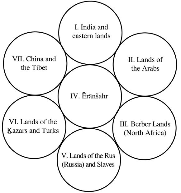
The Parthian and Sasanian empires were also divided into provinces and principalities with no evident regard to the “seven regions” system. The later Sasanians had adopted the (Greek) division of the world into four quarters (see Nāma-ye Tansar, p. 40, tr. p. 63; Ebn Faqih, p. 197) and administered Ērānšahr in four geographical sections (kōsts) of the north (abāxtar, identified as Ādur-bādagān), east (xwarāsān), south (nēmrōz) and the west (xwarwarān). The application of the geographical directions likewise influenced the doctrine of the seven-fold division of the earth (for a detailed and well-documented discussion see Pur(-e) Dāwud, 1952). Thus the Bunda-hišn, while admitting that “there are 33 kinds of land” (8.1), coordinates the seven regions with the four cardinal points, placing one in the east, one in the west and a pair in both north and south (8.2-7). The same is done by Ḥamza Eṣfahāni (pp. 4-5) and Tāriḵ-e Sistān (p. 23).
Similarly, the prologue to the Šāh-nāma of Abu Manṣur Moḥammad b. ʿAbd-al-Razzāq (q.v.) gives the following report (Qazvini, pp. 42-44), from a source datable to about 620, when Sasanian troops had conquered Egypt (Shahbazi, 1990, p. 214): “the earth is divided into four directions (čahār-sūy) from one end to the other, and (also) into seven parts (haft bahr), each part of which they called a kešvar. The first is Arzah, the second Ša-bah, the third Faradadafš, the fourth Vidadafš, the fifth Vurubarst, the sixth Vurujarst, (and) the seventh, which is the center of the world, Ḵoniras-e bāmi (splendid Ḵoniras), and it is the one wherein we are, and the kings called it Ērānšahr.” The same text then enumerates the countries of the world, from China to the Byzantine Empire, in accordance with the four directions, and again comes to Ērānšahr, claiming that it “is from the river of Egypt [the Nile] to the Āmuya” and “surpasses in every art the other kešvars surrounding it” (Qazvini, pp. 44-49). Another elaborate “Iranian” scheme of the “seven kešvars, similarly arranging known nations into six connectedcircles surrounding the central Ērānšahr was given by Abu Rayḥān Biruni, together with a sketch map, both reproduced by Yāqut (Boldān I, p. 27). The Ketābal-tafhim, attributed to Biruni, and the anonymous Mojmal al-tawāriḵ (ed. Bahār, pp. 478-81) give a simpler version of the scheme.
Plate II. The Seven Regions according to late Sāsānian and early Islamic scholastic views.
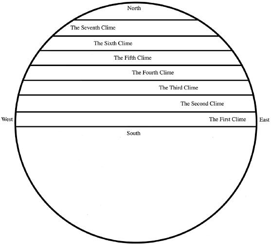
Further developments came as the result of familiarity with the Greek tradition of dividing the terrestrial sphere into four quarters, two above and two below the Equator, and holding that only the one covering the continents of Asia, Africa and Europe, was habitable. This quarter contained various nations living in a number of klimas, “climes” or regions (24 according to Ptolemy but seven in Pliny, Natural History 6.34). Muslim scholars adopted this scheme, and recorded quite accurate geographical data and maps. Some (e.g., Yaʿqūbi, the author of the Ḥodud al-ʿālam, Eṣṭaḵri, Ebn Ḥawqal, and Moqaddasi) rejected the doctrine of the seven kešvars; others adapted the system of klimas (aqālim, sg. eqlim) to their factual descriptive geography of administrative and political entities; and some (e.g., Ṭabari, I, p. 154; Masʿudi, Tanbih, pp. 31-32) could not escape the influence of the traditions of Iran and Mesopotamia (Miquel). Ebn Kordāḏ-beh starts (p. 4) with a description of the spherical earth divided into four quarters and then explains (p. 5): “We live in the northern quarter, and the southern quarter is desolate because of heat; the other half, which is below (i.e., on the other side of) us, is uninhabited. Each quarter, whether in the north or south, is divided into seven eqlims. Ptolemy mentions in his book 4,200 towns which flourished at his time.” Characteristically, Biruni remarked that restricting the inhabited lands to one quarter was unscientific and that one logically expected inhabited quarters on the other side of the globe as well (India, ed. E. Sachau, pp. 133, 135, cited by Homāʾi, intro. to al-Tafhim, p. 132).
Plate III. The Seven Climes (early Islamic adaptation of the Ptolemaic view).
Plate IV. PLATE IV. The world according to early Islamic scientists.
In due course and under the influence of astronomers, the seven eqlims came to be pictured as seven tracts of land above and parallel to the equator, each belonging to a planet and associated with one or two signs of the zodiac (Miquel). The specifically Iranian (as against the Roman) system is given by Yāqut (Boldān I, pp. 25-32), Masʿūdī (Muruj I, pp. 181-82) and Eḵwān al-Ṣafā (Rasāʾel I, Beirut, 1376/1957, pp. 120-38) as follows: The first eqlim belonged to Kayvān (Saturn) and associated with Capricornius and Aquarius; the second eqlim belonged to Hormoz (Jupiter) and associated with Sagitarius and Pisces; the third one belonged to Bahrām (Mars) and associated with Aries and Cancer; the fourth one belonged to Ḵaršād (ḵoršid ‘sun’) and associated with Leo; the fifth one belonged to (A)Nāhid (Venus) and associated with Taurus and Libra; the sixth eqlim belonged to Tir (Mercury) and associated with Gemini and Virgo; and number seven belonged to Māh (the moon) and associated with Cancer. It is this scheme that Nezāmi Ganjavi elaborated in his Haft-peykar (q.v.), describing how Bahrām Gōr married seven princesses from seven lands and built for them seven palaces painted in the colors of the seven planets, who are also the lords of the seven days of the week.
Bibliography:
Christian Bartholomae, Zur Kenntnis der mitteliranischen Mundarten III, Heidelberg, 1920.
Abu Rayḥān Biruni, Ketāb al-tafhim le-awāʾel ṣenā-ʿat al-tanjim, ed. Jalāl Homāʾi, Tehran, 1318 Š./1939.
Arthur Christensen, Les types du premier homme et premier roi dans l’histoire legéndaire des iraniens I, Stockholm, 1917.
Idem, Les Kayanides, Copenhagen, 1931.
James Darmesteter, E´tudes Iraniennes, 2 vols, Paris, 1883.
Eḵwān al-Ṣafā, Rasāʾel Eḵwān al-Ṣafā wa Ḵollān al-wafāʾ, ed. Ḵayr-al-Din Zerekli, 4 vols., I, Cairo, 1341/1928.
Ilya Gershevich, The Avestan Hymn to Mithra, Cambridge, 1959.
Jean-Jacques Glassner, “The Use of Knowledge in Ancient Mesopotamia,” in Jack M. Sasson, ed., Civilizations of the Ancient Near East, 4 vols., New York 1995, III, pp. 1815-23.
Walter Bruno Henning, “Ein persischer Titel im Altaramäischen,” in Mathew Black and Georg Fohrer, eds., InMemoriam Paul Kahle, Berlin, 1968, pp. 138-45; repr. in idem, Selected Papers II, Acta Iranica 15, Tehran and Liége, 1977, pp. 659-66.
Idem, Sogdica, London, 1940; repr. in idem, Selected Papers II, Tehran and Liége, 1977, pp. 1-68.
Ernst Herzfeld, Zoroaster and His World, 2 vols., Princeton, 1947.
S. Insler, The Gāthās of Zarathustra, Act Iranica 8, Tehran and Liége, 1975.
Josef Markwart, “Das Naurōz: Seine Geschichte und seine Bedeutung,” in Dr. Modi Memorial Volume: Papers on Indo-Iranian and Other Subjects, Bombay, 1930, pp. 709-65.
B. A. Miquel, “Iḳlīm,” in El2 II, pp. 1076-78. Nāma-ye Tansar, ed. Mojtabā Minavi, Tehran, 1311 Š./1932; tr. Mary Boyce as The Letter of Tansar, Rome, 1968.
Henrick Samuel Nyberg, Die Religionen des Alten Iran, tr. Hans Heinrich Schader, Leipzig, 1938.
Plato, The Works, ed. and tr. Robert Greg Bury, Loeb Classical Library 7, rev. ed., Cambridge, Mass., and London, 1942.
Ebrāhim Pur(-e) Dāvud, “Čār-su,” in Hormazd-nāma, 2 vols., Tehran, 1331 Š./1952, I, pp. 389-402.
Idem, “Haft kešvar,” in idem, Visperad, ed. Bahrām Faravaši, Tehran, 1343 Š./1964, pp. 109-17.
Mirza Moḥammad Qazvini, ed., “Moqaddema-ye qadim-e Šāh-nāma,” in idem, Bist maqāla, ed. ʿAbbās Eqbāl Āštiāni, 2 vols., Tehran, 1313 Š./1934, II, pp. 5-90.
Martin Schwartz, “The Old Eastern Iranian World View According to the Avesta,” in Camb. Hist. Iran II, pp. 640-63.
A. Shapur Shahbazi, “Darius’ Haft Kišvar,” in Heidemarie Koch and David N. MacKenzie, eds., Kunst, Kultur und Geschichte der Achämenidenzeit und ihr Fortleben, AMI, Suppl. 10, Berlin, 1983, pp. 239-46.
Idem, “On the Xvadāy-nāmag,” in Iranica Varia: Papers in Honor of Professor Ehsan Yarshater, Acta Iranica 30, Leiden, 1990, pp. 208-29.
(A. Shapur Shahbazi)
Originally Published: December 15, 2002
Last Updated: March 1, 2012
This article is available in print.
Vol. XI, Fasc. 5, pp. 519-522
A. Shapur Shahbazi, “HAFT KEŠVAR,” Encyclopædia Iranica, XI/5, pp. 519-522, available online at http://www.iranicaonline.org/articles/haft-kesvar (accessed on 30 December 2012).