GEOGRAPHY iv. Cartography of Persia


GEOGRAPHY

iv. CARTOGRAPHY OF PERSIA

The equivalent terms for carte and map in pre-modern Persian and Arabic were ṣūrat (configuration) and occasionally šakl (form), rasm (drawing), or naqš (painting, figure). In contemporary Persian naqša denotes map, while ḵarīṭa in contemporary Arabic and harita in modern Turkish (< Gk xarti) is used (Harvey, 1980, p. 10; idem, 1992, 9. 7; Harley and Woodward, I, p. xvi; Maqbul Ahmad, pp. 1077-78). The current Persian term for cartography is naqša-negārī.

Cartography was usually defined as “the art and science of representing the Earth’s physical features graphically” (Encyclopaedia Britannica II, p. 600; Bagrow, p. 22; Crone, p. xi), but in recent decades a broader outlook has emerged. In 1964, for instance, the British Cartographic Society defined cartography as “the art, science and technology of making maps, together with their study as scientific documents and works of art.” In this context cartography covers all types of maps and globes representing the earth (terrestrial), including religious maps (e.g., qebla), any heavenly body (celestial), and astrological diagrams (Harley and Woodward, p. xv; Wallis, pp. 1-90).

The political boundaries of Persia have been subjected to drastic changes in the course of history. This article deals with the more stable political boundaries of Persia in any historical epoch referred to here.

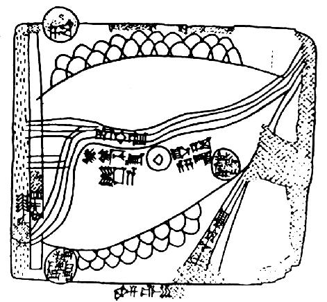
Ancient times. The world’s oldest known topographical map is a Babylonian clay tablet from about 2300 B.C.E. found at Nuzi in northeastern Iraq (Figure 1). It is a relatively advanced picture map, showing two ranges of hills, as seen from the side, and the rivers they flank, by a series of parallel lines. The site covered by this map may have lain between the Zagros mountains and the hills running through Kirkuk (Harvey, pp. 49-50; Harley and Woodward, I, p. 114; Figure 1). The famous Babylonian world map from about 600 B.C.E., preserved in the British Museum, shows a number of cities and places in ancient Persia (Harley and Woodward, I, pp. 111-12).

A systematic study of the skies for calendarial and astrological purposes was begun probably in the earliest period of Babylonian history, some 3,000 years B.C.E. These studies produced star data of amazing quality and accuracy that are still of value to scientists (Brown, pp. 18-21; Harley and Woodward, I, p. 114). Apart from a number of clay tablets that have been found in this region, very little is known about the pre-Islamic cartography in Persia.

Greco-Roman mapping of Persia. The flourishing classical Greco-Roman cartography (6th cent. B.C.E. to 2nd cent. C.E.) may have benefited from the cartographic traditions of ancient Middle East, although it has not yet been possible to tell how far the early Greeks had been aware of, or influenced by, Persian and Babylonian mapping (Harley and Woodward, I, p. 503). Aristagoras (ca. 500 B.C.E.) had a map on which the regions to be crossed on the way from Ionia to Persia were shown. This map was probably originally derived from the map of Anaximander (ca. 611-546 B.C.E.), but it probably also drew on the road measurements compiled by the Persians for their imperial highways (Harley and Woodward, I, p. 193; for the Persian royal roads see Herodotus, II, p. 109).

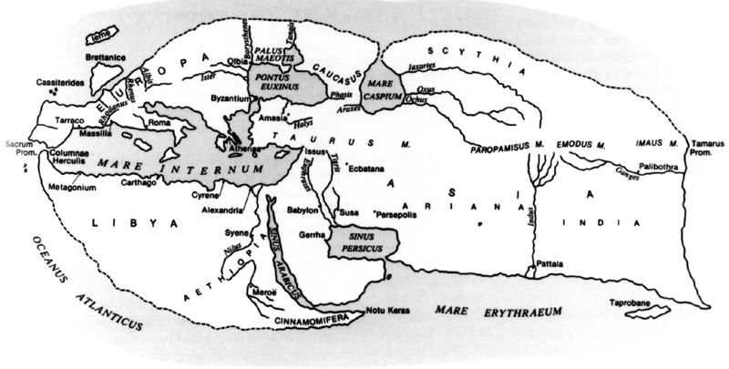
The original maps of this period have not survived. Judging from the much later reconstructed versions of them, one can determine that many cartographers, like Hecataeus (fl. 500 B.C.E.), a scholar of Miletus (Bunbury, I, map facing p. 148), and Dicaearchus (late 4th cent. B.C.E.), a disciple of Aristotle (Cortesao, I, fig. 16), Eratosthenes (3rd cent. B.C.E.; Smith, world map), Strabo (64 B.C.E. to 21 C.E. or later; Bunbury, II, map facing p. 238; see Figure 2), and many others, depicted the Persian Gulf as a wide bay, or an almost rectangular gulf, and the Caspian Sea as a deeper bay or a nearly round gulf, both lying either on the east side of the map or on the two opposite sides (south and north) and branching out of the encircling ocean. The rivers Tigris, Euphrates, and Indus are always clearly shown, and the Iranian plateau, lying in the center of these world maps, is usually not to scale. Some othe maps, however, such as the world map of Herodotus (Encyclopaedia Britannica II, p. 471), show the Caspian as an inland sea.

Ptolemaic maps of Persia. It is believed that the original maps of Ptolemy have not survived. The oldest Greek codices that reached medieval Europe were from the 12th and 13th centuries with maps reconstructed from the texts, or partly derived from the original maps. The first Latin translation of the Geographia /Cosmographia, directly from Greek, was completed in 1406. Further manuscript copies appeared mainly during the first half of the 15th century (Ptolemy, 1990, intro by L. Pagani). The first printed edition of Geographia with maps appeared in Bologna in 1477, followed by more than fifty editions in Latin and some vernacular European languages, published mainly in Italy and Germany, until 1730 or later, with facsimile copies still being printed (Tooley, pp. 6-7).

All the world maps of Ptolemy show the Persian Gulf (Sinus Persicus) in a nearly rectangular shape, placed almost on the correct latitude, and the Caspian (Mare Hyrcanum) as an inland sea and in an almost oval shape. Persia itself occupies a central position, similar to that in the earlier Greek maps. The large scale regional fifth map of Asia shows Persia with its mountains, fairly correct, rivers, cities, etc. (PLATE I). The sixth and seventh regional maps contain the Persian Gulf and the Caspian Sea as a whole (Ptolemy, 1990, maps 19-21). However, neither the term Persia nor any other term to denote the name of the whole region appeared on these maps. Instead, Ptolemy included the names of the provinces of Persia: Assyria (northwest), Susiana (southwest), Media (north), Hyrcania (northeast), Parthia (east), Persis (south), and Carmania (southeast). In 1548 when the Italian cartographer Giacomo Gastaldi published the first pocket-size atlas in Venice, entitled La Geographia Di Claudio Ptolemeo, he used the title “Persia Nova Tabula” as the name of the Persian empire as a whole (Alai, 1995, pp. 12-14).

European Medieval maps of Persia. Ptolemy does not appear to have influenced later Roman and medieval cartography, which ignored his work and drew its information from earlier cartographic traditions (Ptolemy, 1990, p. vi). In well over a thousand world maps that have survived since the 7th century (Harvey, 1991, p. 19), Persia is shown in the center of Asia, usually oversized. Most of these medieval world maps, known as mappa mundi, were of T-O type, showing the world as a round plate, an “O,” divided in three sections by a “T” showing the three major waterways, namely the rivers Don and Nile and the Mediterranean Sea. These three sections represented the known continents of Asia covering the upper half, and Africa and Europe covering the lower half of the plate. As in ancient Greek maps, the Persian Gulf appeared on these medieval maps as a bay or gulf on the right side, and the Caspian as another gulf on the left side of Asia, both connected to the ocean surrounding the land masses.

The medieval world maps, based on the above cartographic tradition, include the maps by Isidore, the bishop of Seville (7th cent.), Henry of Mainz (12th cent.), the so-called Psalter and Ebstorf maps, the map by Richard de Bello (Hereford map, 13th cent.), and by Higden and Pietro Vesconte (14th cent). Nevertheless, a few maps, mainly of late 14th and of 15th centuries, in particular the Catalan Atlas (1375) and the Fra Mauro map (1459), showed the Caspian as an inland sea, perhaps under the impact of the reappearing Ptolemaic maps. They showed the Caspian Sea much closer to its real shape, but not real position, and thus were superior to all Ptolemaic and later European maps before 1720-30, which continued to depict the Caspian Sea in an oval shape (Harley and Woodward, I, plates 15-22 and sec. 18; Harvey, 1991, pp. 19-37).

The Peutinger map, drawn in the 12th or early 13th century from a 4th century Roman archetype, shows Persia in its sections 10 and 11. This map covers Persida (Persia), Media Maior, Parria (Parthia), the Caspian Sea, and the Persian Gulf with numerous islands. The whole region is called Ariae. The distances from Ecbatana (q.v., present-day Hamadān) up to the Indus have been given in Persian parasangs, i.e. roughly 6 km, perhaps based on a Seleucid (312-64 B.C.E.) itinerary (Harley, p. 238; Tabula Peutingeriana, pp. 14, 28, 29).

Persian cartography during the early Islamic period. Persian geographers were the main contributors to the thriving field of cartography throughout the early Islamic period (8th to 14th cent.). The rapid expansion of Islam during the period of 621-750 created a vast empire with Arabic as its official language (Brice, map on p. 7), and thus men of letters, whatever region they came from, had to communicate in Arabic to flourish. It was only much later that scholarly works were translated into or produced in Persian.

Persians must have inherited some cartographic traditions from their pre-Islamic period, such as dividing the inhabited world into seven geographical regions as opposed to the Ptolemaic climate zones. In 83/702 the first known map made in the Islamic world (not extant), showing the region of Deylam, south of the Caspian Sea, was prepared for Ḥajjāj b. Yūsof (d. 95/714), the governor of the eastern part of the Islamic world (Ebn Faqīh, p. 283). In 89/707, he ordered a plan of Bukhara area to be used for the siege of the city (Ṭabarī, II, p. 1199). Abū Esḥāq Ḥabīb b. Ebrāhīm Fazārī, a well-known astronomer in Baghdad (2nd/8th cent.), is reportedly the first person in Islam to make an astrolabe (Ebn al-Nadīm, ed. Flügel, I, p. 273, ed. Tajaddod, p. 332, tr. Dodge, II, p. 649).

The ʿAbbasid caliphs Hārūn al-Rašīd and his son al-Maʾmūn were great patrons of learning. The first Islamic world map was constructed in this period in the Bayt-al-Ḥekma (House of wisdom) that al-Maʾmūn (198-219/813-33) had establised in Baghdad in imitation of the academy of Jondēšāpūr. According to Masʿūdī (d. 345/956), this map, the Map of al-Maʾmūn (al-Ṣūrat al-maʾmūnīya), represented the world with its spheres, stars, lands and seas, the inhabited and uninhabited regions, settlements and peoples, cities, and was better than anything that preceded it, such as the geography of Ptolemy, Marinus, or any other (Tanbīh, p. 33).

Ebn Ḵordādbeh (fl. 9th cent., q.v.), one of the earliest Persian geographers, produced in 232/846 his major work Ketāb al-masālek wa’l mamālek, which is considered the foundation for the later Balḵī school of geography (Harley and Woodward, II/1, pp. 128-29). Moḥammad b. Mūsā Ḵᵛārazmī’s (d. 233/847) geographical work Ketāb ṣūrat al-arż was evidently influenced by Greek cartography, as it gives in a tabulated form the coordinates of the places according to the Ptolemaic climes. The work must have been originally accompanied by regional maps of each of the climes, or by a single world map, but none of these appears to have survived. However, these maps, which may be called the Greco-Muslim tradition in cartography, differ from the maps of Ptolemy in several aspects, such as their projection and the subdivision of the climes (Maqbul Ahmad, pp. 1078-79).

During the 10th century the first school of Islamic geography/cartography was well established. It was mainly based on Greek traditions, of which the only known example is the short description given by the Persian geographer Sohrāb b. Sarābīūn (fl. 10th cent.), the author of ʿAjāʾeb al-aqālīm al-sabʿa (Harley and Woodward, II/1, p. 95).

At this time, Abū Zayd Balḵī (235-322/849-934, q.v.) initiated a new cartographic tradition which deeply influenced the later cartographers and became the more popular style in the Islamic world. His geographical work Ṣowar al-aqālīm was based on the ancient Persian tradition of dividing the inhabited world into seven geographical regions called kešvar, in contrast to the Ptolemaic seven-clime system. His “work was a description of the maps of the provinces drawn by the author with their boundaries, main cities, rivers, mountains and main roads. He also drew maps of the Indian Ocean, the Mediterranean Sea, the Caspian, and a world map, in which Mecca occupied the central position” (Maqbul Ahmad, p. 1079).

Neither the geographical work nor the maps of Balḵī are extant. However, Abū Esḥāq Eṣṭaḵrī (d. 347/957, q.v.), who may be considered as the greatest Persian cartographer of the Islamic classical period, incorporated Balḵī’s treatise in his book Ketāb al-masālek wa’l-mamālek and copied and probably improved his maps. Eṣṭaḵrī drew twenty colored provincial maps and a world map which were attached to his book (PLATE II; for Eṣṭaḵrī’s maps see Kamal, III, pp. 584-622; for the list of the preserved early manuscript copies of Eṣṭaḵrī’s book see Harley and Woodward, II/1, pp. 130-35).

The second leading scholar of the Balḵī school was Ebn Ḥawqal (q.v.), whose travels extended over most of the Islamic world. During them he met Eṣṭaḵrī and revised some of his maps upon the advice of Eṣṭaḵrī (Miquel, p. 787; Kramers, II, pp. 9-30; Alai, 1992, p. 8). He composed his Ketāb ṣūrat al-arzµ (comp. 379/988), which contains twenty-two maps, including one of the world. His maps can be seen as an improved version of Eṣṭaḵrī’s maps.

Some names among the many Persian geographers/cartographers of this period are noteworthy: Abū ʿAbd-Allāh Moḥammad Jayhānī (fl. 319/930), a vizier to the Samanids in Khorasan and author of Aškāl al-ʿālam, which contained a number of colored maps; Ebn Faqīh Hamadānī (q.v., fl. early 10th cent.), author of Ketāb al-boldān; and ʿAbd-al-Raḥmān Ṣūfī Rāzī (Azophi: 291-376/903-86), an astronomer from Ray and author of Ṣowar al-kawākeb al-ṯābeta. The author of the anonymous geographical work, Ḥodūd al-ʿālam, compiled in about 372/982, is believed to have worked on the basis of a modified map (not extant) of Abū Jaʿfar Moḥammad Ḵāzen Ḵorāsānī (d. ca. 360/970, q.v.; Ḥodūd al-ʿālam, tr. Minorsky, tr.’s preface, p. xlix; Maqbul Ahmad, pp. 1079-80).

Abū Rayḥān Bīrūnī (363-442/973-1050, q.v.) believed that the land masses were surrounded by the encircling ocean (al-baḥr al-moḥīṭ), and the Indian ocean was connected with the Atlantic through certain channels south of the Mountains of the Moon (Jebāl al-Qamar), the traditional sources of the Nile River (Bīrūnī, fol. 58a, Pers. version, pp. 167-69). Thus, in his map the Ptolemaic terra incognita was replaced by a sea which covered most of the southern quarter, and Africa became smaller in size (Maqbul Ahmad, p. 1080; Harley and Woodward, II/1, pp. 141-42). Persian religious mapping (qebla maps, pilgrimage maps, etc.), and celestial cartography were also advanced during the 12th century. The early celestial globe made by Badīʿ-al-Zamān Badr b. ʿAbd-Allāh (535/1140) is preserved in the Īrān-e Bāstān Museum in Tehran (Savage-Smith, p. 247).

Although classical Persian cartography seems to have passed its peak in the 13th century, one still finds some prominent mapmakers in the late 14th century. Zakarīyāʾ Qazvīnī (600-83/1203-83) composed ʿAjāʾeb al-maḵlūqāt wa ḡarāʾeb al-mawjūdāt (q.v.) and Āṯār al-belād wa aḵbār al-ʿebād. His world map (PLATE III) follows the Balḵī school while keeping some elements of the Greco-Muslim tradition. For instance, following the Balḵī school, the encircling ocean connects the two major seas (Indian and Mediterranean) but it is surrounded by the legendary Mount Qāf which represents the traditional terra incognita of the Greeks (Alai, 1993, pp. 19-23; Maqbul Ahmad, p. 1081). Naṣīr-al-Dīn Moḥammad Ṭūsī (598-673/1201-74) entered the service of the Il-khanid Hulāgū Khan in 654/1256, and founded and ran a major observatory in Marāḡa, south of Tabrīz, and produced the Zīj-e īl-ḵānī in Persian. He trained many scholars in his observatory, one of them Qoṭb-al-Dīn Maḥmūd Šīrāzī, who continued his master’s work after his death (Harley and Woodward, II/1, p. 183; Ṣafā, Adabīyāt III, pp. 1227-30).

Ḥamd-Allāh Mostawfī Qazvīnī (d. after 1349), author of the Nozhat al-qolūb (comp. 741/1340), introduced graticulation to Islamic cartography using a grid of horizontal and vertical lines, similar to latitudes and longitudes in the Mercator projection (16th cent.) to indicate geographical positions. This new practice had some similarity to the Chinese rectangular grid system, used as a scale to indicate distances. I. I. Krachkovsky believed that Persian cartographers possibly influenced Chinese mapping through Mongolia (Maqbul Ahmad, p. 1081). In the world map of Mostawfī, the inhabited world is divided into eighteen equal longitudinal and nine latitudinal squares, every square representing 10° x 10°. In his large scale map of Persia, called “Irankarte” by Konrad Miller, each square represents 1° x 1° (Miller, V, Tafeln 83-86, Weltkarten 178-82). Ebn Bakrān Ḵorāsānī preceded Mostawfī in introducing graticulation with his book Jahānnemā (comp. 605/1208; Faršād, pp. 267-69).

Ḥāfeẓ-e Abrū (d. 833/1430) also used the grid system for his maps and embarked on compiling a comprehensive book on geography supported by maps, allegedly being mainly a translation of an Arabic work, but left it unfinished and untitled to be known later as Ketāb-e-joḡrāfīā. Oloḡ Beg (1394-1449), a grandson of Tīmūr who became king in 850/1446, built an observatory (823/1419 or later) in his capital Samarqand and employed a host of astronomers and scientists to work for him. Drawing from the astronomical tables of Naṣīr-al-Dīn Ṭūsī and based on his own observations, he and his team produced Zīj-e Oloḡ Beg, which was considered an advanced astronomical handbook. During his observations, Oloḡ Beg discovered a number of errors in the computations of Ptolemy, whose figures were still being used by astronomers of the time (Harley and Woodward, II/1, pp. 8, 56-57, 64, 198, 316, 361, 365, 379; Ṣafā, Adabīyāt IV, pp. 102-3).

Throughout the centuries in which Islamic cartography was flourishing, mapmakers of the other Islamic countries always included Persia or its provinces in their maps. In particular, the work of Moḥammad Šarīf Edrīsī (493-560/1100-1165), which is seen as the climax of Islamic cartography in the Greco-Muslim tradition, is noteworthy. His mapping of Persia in his sectional world map (70 sections, attached to his Nozhat al-moštāq fī eḵterāq al-āfāq), was more accurate than in any European world map of the time (e.g., the shape of the Persian Gulf and the size of the country).

The decline of indigenous cartography in the Muslim world coincided with the European Renaissance, the reconstruction of the Ptolemaic maps, and the age of discovery. Consequently, cartography in the Islamic world became increasingly influenced by its Western counterpart, rapidly losing its originality. As a result, most of the later Persian and other Islamic mapmakers were insignificant in terms of creativity.

The interest of the Safavids (907-1145/1501-1732) and the later Persian dynasties until the reforms of the early 20th century seems to have been limited to the maps and charts needed for military and religious purposes. The only notable Persian cartographer of this period is Mīrzā Moḥammad-Ṣādeq Eṣfahānī (d. 1061/1651) the author of Šāhed-e ṣādeq, also referred to as “The Persian Atlas” (Harley and Woodward, II, p. 146, n. 46), which includes a world map and thirty-two regional maps (Gole, pp. 82-87). Noteworthy also is Ebrāhīm Motafarreqa (1081-1158/1670-1745), an Ottoman diplomat and geographer of Hungarian origin, who drew a map of Persia with Turkish descriptions, printed in 1142/1729 in Constantinople. This map seems to have been copied from Homann’s map of Persia, entitled “Imperii Persici,” which appeared in his World Atlas of 1725.

European Mapping of Persia (16th-18th cents.). All printed European world maps (Shirley, maps 42-43, 54 and later maps), globes, maps of Asia, and regional maps of Western Asia have always incorporated Persia as a major country.

Low Countries. Apart from Ptolemaic maps, however, no separate map of Persia appeared until 1570, when Abraham Ortelius (1527-98) from Antwerp published his Theatrum orbis terrarum. This first modern uniform atlas of the world contained a new map of Persia entitled “Persici Sive Sophorum Regni Typus” (The map of Persia or the Safavid kingdom), which was based on contemporary geographical knowledge (Skelton, Intro.). On the back of the map Persians were described as “by nature a Gentleman-like and honourable Nation, very civill and curteous, loving learning and liberall Sciences …” (Ortelius, p. 109). The same map was included in all later editions of the Theatrum until 1612. The small atlas of Ortelius, known as the Epitome, first published in 1577 with many further editions until 1724, contained a small map of Persia. In the atlas of Gerhardus Mercator (1512-94) a new map of Persia first appeared in the Hondius edition of 1606. An updated version of this map was included in the Mercator atlases published by Janssonius after 1636.

The House of Blaeu in Amsterdam printed in 1629 a small atlas which contained fifty-seven maps, including one of Persia. Jean Blaeu culminated his work in 1662 with publication of the Atlas Maior in nine to twelve volumes with some six hundred maps, believed to be the most expensive printed book in the 17th century (Tooley, 1982, pp. 33-34; Blaeu, Intro., pp. 9-13). Included in all Blaeu atlases (either volume IX or volume XI, depending on the individual set) was a fine map of Persia with a title cartouche showing three figures, perhaps Shah ʿAbbās I (q.v.) with two of his soldiers.

It seems that the improvements presented by Adam Olearius (or Ölschläger, a German traveler and diplomat, 1599-1671) in his map entitled “Nova Delineatio Persiae et Confiriorum/A New Map of Persia,” drawn in 1646, and the new historio-geographical data provided by Engelbert Kaempfer (1651-1716) did not influence the great mapmakers of the time (Lazar, II, p. 594), as, for instance, the map of Persia by Fredrick De Wit (1610-1698), drawn in the late 17th century, is very similar to the map of Blaeu. He must have used Blaeu’s copper-plate with minor changes, as it was then customary to purchase a copper-plate from an earlier mapmaker, include some minor changes, add one’s own name as cartographer, and print it as a new map (Campbell, pp. 2-10).

Therefore, the various maps of Persia produced by Mercator, Hondius, Jansson, Blaeu, De Wit and some later Dutch cartographers should be seen as one original map with minor revisions and improvements. On these maps, the western boundaries of the country are normally shown by a dotted line, while the eastern borders are not marked, since they may have not been known to the mapmakers. For coloring purposes, however, the map colorists chose some rivers etc., entirely at their own discretion, as the eastern boundaries, which have no historical basis.

Many later Dutch cartographers of the 17th and early 18th century, such as Pieter van der Aa (1659-1733), Pieter Schenk (1645-1715), and Isaac Tirion (1705-65), also produced modern maps of Persia. Jansson included Isfahan, the capital of the Safavids, in his great series of town books (1657) in the form of a panoramic map. Van der Aa printed in Leiden a number of Persian city maps (1719), such as maps of Ardabīl (PLATE IV), Solṭanīya, Qom, Kāšān, Isfahan, Gomron (Bandar ʿAbbās), etc., based on Adam Olearius.

French maps. Nicholas Sanson (1600-1667) initiated the great school of French cartography which lasted until the late 18th century, shifting the center of map production from the Low Countries to France (Tooley, 1982, p. 40). He included a map of Persia in his atlas Cartes générales de toutes les parties du mund (Paris, 1658). J. B. B. d’Anville (1697-1782) drew an improved map of the Persian Gulf in 1758, using the new British surveys and the information compiled by Kaempfer in 1712 (Lazar, II, p. 594). He also produced a map of the Caspian Sea in 1754 and one of Persia in about 1794. Many other French cartographers also produced new maps of Persia, such as Pierre du Val (1618-83), Nicholas de Fer (1646-1720), Guillaume de L’Isle (1675-1726), George Louis Le Rouge (fl. 1740-80), Gilles Robert de Vaugondy (1723-86), and Rigobert Bonne (1727-95).

German maps. German cartographers seem to have been the first European mapmakers to recognize the native name of the country, Iran. “Imperium Timuri 1405” is the title of a historical map by an anonymous German mapmaker, printed in 1740. On this map the term “Iran” is exclusively employed as the name of the empire. Some other German cartographers, being aware of the native name of the country, printed both terms “Iran” and “Persia” in their maps. For instance, the map of Carl Christian Franz Redefeld (1788-1874), incorporated in Meyers grosse Hand Atlas (1846), and the map drawn by Hermann Habenicht (1844-1917), included in Stieler’s Hand Atlas (1881), both carry the title Iran … , with the term Persia used on the face of these maps (Alai, 1995, pp. 16-17). Johann Baptist Homann (1663-1724) and his rival Georg Mattäus Seutter (1678-1757) both produced elaborate and decorative maps of Persia (Homann, World Atlas, Nuremberg, 1725; Seutter, Atlas novus, Augsburg, 1730), showing the provinces of the country and the Caspian Sea close to its real shape, based on the new surveys of 1720. Adam Olearius travelled in Persia in the years 1635-39, leading a trade mission from his country, Schleswig-Holstein. He learned Persian and translated Saʿdī’s Golestān into German. He also produced a rather detailed “New Map of Persia” and the neighboring regions in 1646, using a copper plate 52 x 38.5 cm. On this map, mountains and rivers are depicted more accurately and the oval shape of the Caspian Sea changed to rectangular, much closer to its real shape. Many new names of Persian cities (e.g., Tabrīz, Ardabīl, Qazvīn, and Hamadān) appeared on this map.

English maps. English mapmakers hardly matched their counterparts in Europe until the end of the 18th century, when England became the premier maritime and commercial power and made great contributions to cartography. This success was supported by scientific advancements made by the Trigonometrical (later Ordinance) and Admiralty Hydrographic Office surveys (Tooley, 1982, p. 47). Thus, the English mapping of Persia was rather limited until the late 18th century.

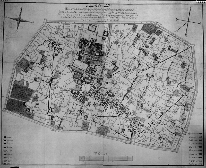
John Speed (1552-1629) incorporated in 1627 a decorative map of Persia in the first English world atlas, The Prospect of the Most Famous Parts of the World. This map, entitled “The Kingdom of Persia,” showed on its bordering panels panoramic views of four Persian cities and illustrations of eight national characters in local costume (PLATE V). John Seller (d. 1697) included a small map of Persia in his Atlas Minimus (1679). Richard Blome (d. 1705), Robert Morden (d. 1703), Hermann Moll (originally German, d. 1732), Emanuel Bowen (1720-67) and Thomas Kitchin (1718-84) were among the early English cartographers who drew new maps of Persia.

Other maps. Mapmakers from some other countries also produced maps of Persia. From Italy, Giacomo Cantelli (1643-95), Giacomo Rossi (fl. 1650-90), Paulo Pertini (fl. early 18th cent.), and Antonio Zatta (fl. late 18th cent.) are noteworthy. The Russian authorities employed a few cartographers from The Netherlands, such as Captain K. van Werden, who surveyed the Caspian Sea in 1720 and later contributed to improving the mapping of this inland sea.

19th and 20th centuries. The real improvement in mapping of Persia started early in the 19th century. It resulted mainly from the new European surveys and numerous expeditions and travel accounts, which contained a few hundred detailed routes and regional maps, such as the “Map of Khorasan …” by Lieut. Col. C. E. Stewart, printed in 1881 by Edward Weiler for the Royal Geographical Society and “The Karun River and Branches,” compiled from the charts of Col. Chesney, Lieut. Selby and Capt. Clements and printed in 1890 by W. and A. K. Johnson for the Royal Geographical Society. These are the most accurate maps of that period. Pierre Amédée Jaubert (1779-1847), a member of the Gardane mission (q.v.) sent by Napoleon Bonaparte to the court of Fatḥ-ʿAlī Shah (r. 1794-1844), compiled a new map of Persia which he attached to his book Voyage en Arménie et en Perse … (Lazar, II, p. 594). Aristide Michel Perrot (1793-1879) and a few other French cartographers also produced new maps of Persia.

A Russian expedition, supervised by Nikolai V. Khanykov (Khanikoff), traveled in northwestern Persia during 1851-55 and in Khorasan during 1858-59 and provided new material for Henrick Kiepert (1818-99) to draw a new map of the province of Azerbaijan (1:800,000; Berlin, 1862), and for J. Sulzer to prepare the map of the “Russian Scientific Expedition in Khorasan” (1:3,350,000; Berlin, 1860; Lazar, II, p. 594). Kiepert drew also a map of Persia to be included in the Atlas von Asien, published by K. Ritter, Berlin, 1852. From 1886 to 1889, under the supervision of I. Stebnitsky, a large-scale (1:840,000) map of Persia and some neighboring countries was compiled and printed in 14 sheets in Tbilisi. This Russian map incorporated all the material available by then, and thus was superior to other similar maps of the time (Lazar, II, p. 595). A “Schematic Map of Persia” (Skhematich eskaya karta Persiĭ), drawn by N. P. Passek, the Russian consul in Būšehr, was printed in Moscow in 1911 (double sheet, 1: 1,700,000; 117 x 75 cm), on which the Russian zone of influence in northern Persia, and the British zones of influence in southern and eastern Persia were marked by strong red lines.

The German contribution to the mapping of Persia was partly based on the Russian and British surveys. The map of Graessl, “Neuste Spezialkarte von Persien,” incorporated in Meyer’s Handatlas (Leipzig, 1855), was detailed and practical. Among the German maps of Persia that appeared during World War II was a large map (1:200,000) compiled mainly from the Survey of India, revised, and printed in 1941-42.

A British comprehensive survey of the shores and islands of the Persian Gulf, which was carried out during 1820-29 by the Bombay Marine, resulted in thirty-one charts and harbor plans called “East India Company Charts of the Persian Gulf.” These charts were supported by textual descriptions and watercolor coastal views (Cook). During the 19th century, which is considered as the epitome of British cartography, numerous British mapmakers produced new maps of Persia and the Persian Gulf. Among them, the John Carys (1754-1835) et al., the Aaron Arrowsmiths (1750-1823) et al., Daniel Lizars Sr. (fl.. 1776-1812), John Pinkerton (1758-1826), John Tallis (fl. mid-19th cent.), William and Alexander Keith Johnson (1825 onwards), and the House of Laurie and Whittle (fl. 1795 until late 19th century) are a few examples.

In 1813, Aaron Arrowsmith Sr. published a large double-sheet map of Persia (200 x 130 cm), drawn by John MacDonald Kinneir. The intelligence division of the War Office in London compiled a detailed and large “Map of Persia” in 1886 (1:1,013,760; 6 sheets, each 61 x 91 cm). This map was at first inferior to the Russian map by Stebnitsky, but was revised and improved in 1891, mainly using the new material supplied by the Surveyor General of India. In 1898, this map was updated and re-drawn by Simla Drawing Office of the Survey of India and printed in Dehra Dun.

In 1892, the Royal Geographical Society in London published a new map, drawn by W. J. Turner under the supervision of George Nathaniel Curzon (1:3,810,000; 62.5 x 51.5 cm), known as the Curzon map of Persia (Curzon, pp. 69-78; Burgess, pp. 454-60). The largest map of Persia by the Surveyor General of India appeared in 1941-42 during World War II, printed in Dehra Dun (1:50,000; on sheets of 40 x 40 cm). This large-scale map was improved and reprinted by the War Office and the Air Ministry in London in 1962, and remained the largest and most detailed map of Persia until 1992, when the National Survey Organization of Iran (Sāzmān-e naqša-bardārī-e kešvar) produced a map of yet larger scale (1:25,000) in Tehran.

A few American cartographers were active in the mapping of Persia before World War II. Samuel Augustus Mitchell of Philadelphia (1792-1868) published a map of Persia in 1860 with later editions. During World War II and thereafter, American maps of Persia appeared in ever-increasing editions. The United States Army Map Service compiled a military map in 1943 entitled “Iran: Special Strategic Map” (1:4,000,000; 53 x 44 cm), and in 1961 a map of Iraq and Persia (1:100,000; on sheets of 56 x 46 cm). The Central Intelligence Agency produced a map of Persia in 1978 (1:4,000,000), and a map of Iraq and Persia (1:670,000) in 1980.

In the 20th century, two special events influenced the titles of the Western maps of Persia. In 1935, the government of Persia asked the outside world to replace in official communications the term Persia and its variations in other languages, such as Perse and Persien, with the native name of the country, Iran. In 1949, however, the government of Persia declared that given the widespread use of the term Persia and its variations in the West, Persia and Iran were both official names of the country (Yarshater; Alai, 1995, pp. 12-17). Hence, since 1935 Iran became the title of most maps, and occasionally both terms were used.

After World War II, some circles decided to change the name of the Persian Gulf to Arabian Gulf. Although the government of Persia opposed the move vehemently, in some editions of a few maps and atlases the term Persian was omitted, leaving only “The Gulf” (e.g., The TimesAtlas, p. 39), while the historical term Persian Gulf mostly remained intact, as in the National Geographic Atlas (p. 77; fig. 7).

During the 19th and early 20th centuries, a few Persian cartographers, benefiting from the European surveys, and using their own local geographical studies and reviews, produced a number of maps, usually in Persian and occasionally including a second language such as French or English. For instance, Ḥājī Mīrzā Ḥasan Fasāʾī toured Fārs in 1274/1857 and compiled a topographical map of the province in Persian and French. His map was presented in 1293/1876 to Nāṣer-al-Dīn Shah (r. 1264-1313/1848-95), and upon the shah’s order he composed a lengthy geographical treatise about the province in connection with the map, called Fārs-nāma-ye nāṣerī (q.v.). His map (1:570,240; 182 x 125 cm) was finally printed in 1313/1895 in Tehran. On this rather large map, he noted that the latitudes and longitudes of the places were taken from the Scottish cartographer A. K. Johnston (1804-71).

The first official map of Tehran appeared in 1275/1857 (scale 1:2,880; with inscriptions in Persian, 92 x 76 cm), drawn at the suggestion of the grand vizier Mīrzā Taqī Khan Amīr Kabīr (q.v.) by August Křziž, a Czech officer from the Austro-Hungarian Empire teaching at the Dār al-fonūn (q.v.) in Tehran. He was assisted by two of his Persian students. The map shows the old fortifications (ca. 7 km long), the six gates, the royal castle (arg), the commercial center (bāzār), and the other three districts of the city (PLATE VI). Other maps worth mentioning are: a map of Tabrīz and neighborhood drawn by Moḥammad-Reżā Mohandes and Colonel Qarājadāḡī in 1297/1880 (1:8,300; 100 x 97 cm), a new map of the expanded Tehran (some 21 km city wall with 12 gates) made by ʿAbd-al-Ḡaffār Najm-al-Molk in 1309/1891 (1:4,000, 132 x 97 cm), a map of Tehran county by made by ʿAbd-al-Razzāq Baḡāyerī in 1328/1910 (1:200,000, 118 x 74 cm), and a map of Isfahan drawn by Captain Sayyed Reżā Khan in 1302 Š./1923 (1:3,200, 135 x 129 cm).

Although these and similar maps contained legend, description, etc., and proved practical and useful, they were mainly based on European surveys, and rather resembled a leisurely activity by some individuals and officials. Genuine progress started when the Geographical Department of the Armed Forces (Dāyera-ye joḡrāfīāʾī-e setād-e arteš), and later the National Survey Organization (Sāzmān-e naqša-bardārī-e kešvar), a section of the Plan and Budget Organization (Sāzmān-e būdja wa barnāma), were formed under the Pahlavis (1304-57 Š./1925-79). The former carried out an aerial survey of the whole country and produced in 1320-21 Š./1940-41 a new topo graphical map of Persia on twenty sheets (1:1,000,000), each covering an area of 4° x 4°. During 1948-60, this Geographical Department compiled a larger map (1:253,440) on 131 sheets, each covering an area of 1° x 1°. The latter, a civilian organization, improved the general survey of the country by employing satellite photography and produced in 1992 the largest (1:25,000) topographical map of Persia. It divided the country into 132 blocks, each covering an area of 1° x 1°. Each block is mapped on ninety-six sheets (ca. 55 x 48 cm each with legend and index), making a total of 12,672 sheets with a grand surface of ca. 3,345 m2. On this map, many geographical names were replaced by the ones imposed by the Islamic government in 1979 and later.

A “Historical Atlas of Persia” (Aṭlas-e tārīḵī-e Īrān) was published by the University of Tehran in 1350 Š./1971, comprising twenty-six two-page historical maps and three others, with descriptions in Persian, English, and French. Some private cartographic institutions were also founded during the Pahlavi period and later. They produced all sorts of maps and atlases, mainly using the material of the Army Geographical Department and the National Survey Organization. Saḥāb Geographic and Drafting Institute (Moʾassasa-ye joḡrāfīāʾī wa kārtogerāfī-e Saḥāb; founded 1315 Š./1936), and the newly established Gītā-šenāsī Geographic and Cartographic Organization (Sāzmān-e joḡrāfīāʾī wa kārtogerāfī-e gītā-šenāsī) are two such private institutions.


Bibliography:

C. Alai, “Oriental Medieval Maps of the Persian Gulf,” The Map Collector 60, 1992, pp. 2-8.

Idem, “The World Map of Qazwini,” International Map Collectors’ Society 52, 1993, pp. 19-23.

Idem, “Iran or Persia? What do the Maps Say?” The Map Collector 70, 1995, pp. 12-17.

L. S. Bagrow, Die Geschichte der Kartographie, Berlin, 1951; tr. D. L. Paisley as History of Cartography, rev. and enlarged R. A. Skelton, Cambridge, Mass., 1964.

Abū Rayḥān Bīrūnī, Ketāb al-tafhīm le-awāʾel ṣenāʿat al-tanjīm, MS London, British Library, Or 8349; Pers. version, ed. J. Homāʾī, Tehran, 1318 Š./1939.

Joan Blaeu, Blaeu’s The Grand Atlas of the 17th Century World, with intro., captions, and selection of maps by J. Goss, New York, 1990.

W. C. Brice, ed., An Historical Atlas of Islam, Leiden and Edinburgh, 1981.

Encyclopaedia Britannica, 15th ed., 30 vols, Chicago, 1981.

L. A. Brown, The Story of Maps, New York, 1977.

E. H. Bunbury, A History of Ancient Geography among the Greeks and Romans from the Earliest Ages till the Fall of the Roman Empire, 2nd ed., 2 vols, New York, 1959.

J. Burgess, “The New Map of Persia,” The Scottish Geographical Magazine 9, 1893, pp. 454-60.

T. Campbell, “Understanding Engraved Maps,” The Map Collector 46, 1989, pp. 2-10.

A. S. Cook, Survey of the Shores and Islands of the Persian Gulf, 1820-1829, 5 vols, Slough, England, 1990.

A. Cortesao, History of Portuguese Cartography, 2 vols, Lisbon, 1969-71.

G. R. Crone, Maps and Their Makers: An Introduction to the History of Cartography, 5th ed., Folkestone, England, 1978.

G. Curzon, “Memorandum on the Society’s New Map of Persia,” Proceedings of the Royal Geographical Society and Monthly Record of Geography 14/1, 1892, pp. 69-78.

M. Faršād, Tārīḵ-e-ʿelm dar Īrān, 2 vols, Tehran, 1365 Š./1986.

S. Gole, Indian Maps and Plans, New Delhi, 1989.

J. B. Harley and D. Woodward, The History of Cartography, 2 vols., Chicago, 1987-94.

P. D. A. Harvey, The History of Topographical Maps: Symbols, Pictures and Surveys, London, 1980.

Idem, Medieval Maps, London, 1991.

Pierre Amédée Jaubert, Voyage en Arménie et en Perse, fait dans les années 1805-1806 …, Paris, 1821.

Y. Kamal, Monumenta Cartographica Africae et Aegypti, Cairo, 1926-51; ed. F. Sezgin, Frankfurt, 1987.

J. H. Kramers, Analecta Orientalia, 2 vols, ed. H. P. Block, Leiden, 1954-56.

M. Lazar, “Persien (Persia),” in I. Kretschmer, ed., Lexikon zur Geschichte der Kartographie, 2 vols, Vienna, 1986.

S. Maqbul Ahmad, “Kharīṭa,” in EI2 IV, pp. 1077-83.

K. Miller, Mappae Arabicae: Arabische Welt und Landerkarten des 9-13 Jahrhunderts in arabischer Urschaft, 6 vols., Stuttgart, 1926-31; with corrigenda by H. Gaube, Beihefte zum Tubinger Atlas des Vorderen Orients, Reihe B 65, Wiesbaden, 1986.

A. Miquel, “Ibn Ḥawqal,” EI2 III, pp. 786-88.

M. Moʿīn, Farhang-e farsī, 6 vols, Tehran, 1342-52 Š./1963-73.

National Geographic Atlas Of The World, 6th rev. ed., Washington, D.C., 1992.

Abraham Ortelius, Theatrum orbis terrarum, tr. as An Epitome of Ortelius: His Theatre of the World, London, 1616.

Claudius Ptolemy, Cosmographia, Bologna, 1477, facsimile ed., Amsterdam, 1963.

Idem, ClaudiiPtolemaeCosmographia tabulae/Maps from Ptolemy’s Geography, intro. by L. Pagani, tr. S. Knight, Wigston, Leicester, England, 1990.

M. Pūrkamāl, ed., Aṭlas-e tārīḵī-e Īrān/Historical Atlas of Persia, Tehran, 1350 Š./1971.

E. Savage-Smith, Islamic Celestial Globes, Washington, D.C., 1985.

R. W. Shirley, The Mapping of the World, London, 1984.

R. A. Skelton, ed., Theatrum orbis terrarum: A Series of Atlases in Facsimile,1stSeries3,Amsterdam, 1964.

W. Smith, Atlas of Ancient Geography, London, 1874.

Tabula Peutingeriana: Codex Vindobonensis 324, Graz, Austria, 1976.

The Times Concise Atlas of The World, London, 1995.

R. V. Tooley, Tooley’s Dictionary of Mapmakers, Amsterdam, 1979.

Idem, Maps and Mapmakers, 6th ed., London, 1982.

H. M. Wallis and A. H. Robinson, eds., Cartographical Innovations: An Introductory Handbook of Mapping Terms to 1900, Tring, England, 1987.

E. Yarshater, “Īrān-rā dar zabānhā-ye ḵārejī če bāyad ḵᵛānd?” Rahāvard, nos. 20-21, 1989, pp. 70-75.

(CYRUS ALAI)

Originally Published: December 15, 2000

Last Updated: February 7, 2012

This article is available in print.
Vol. X, Fasc. 4, pp. 444-448 and Vol. X, Fasc. 5, pp. 449-456