


FŪMAN, a town and district in western Gīlān (Figure 1). The town of Fūman is located 21 km to the west-southwest of Rašt, on the left bank of Gāzrūdbār River close to the piedmont of Ṭāleš highlands. Fūman was the residence of the Dabuyids (q.v.) between 660 and 761. During the Mongol period, according to the Masālek al-abṣār fī mamālek al-amṣār of Šehāb-al-Dīn Aḥmad ʿOmarī (cited by Rabino, 1915-16, pp. 161-62), Fūman was one of the main towns of Gīlān together with Lāhījān. Its sovereign, the only Shafiʿite among the rulers of Gīlān, secured a high income through silk trade. Ḥamd-Allāh Mostawfī depicted Fūman as a large city, center of a rich district producing abundant wheat, rice, and silk (Nozhat al-qolūb, ed. and tr. Le Strange, II, pp. 158-59). It remained the capital of the Bīapas district of Gīlān until 980/1572-73, when Jamšīd Solṭān transferred his capital to Rašt. A ferocious rivalry opposed the khans of Fūman to their neighbors of Šaft from the time of Shah Solṭān Ḥosayn to the reign of Fatḥ-ʿAlī Shah. The English merchant John Elton (q.v.) was killed in 1751 (Rabino, 1915-16, p. 471) on the order of one of these rulers, Hājī Jamāl. In 1805, Fūman was still a small, open town with about a thousand houses and a very lively market (Jaubert, pp. 441 f.). But after Hājī Moḥammad Khan had left Fūman for Rašt at the beginning of Nāṣer-al-Dīn Shah’s reign, Fūman fell into decay. When Melgunof visited Fūman in 1860, it was no more than a village with only 140 houses around the palace of the khan.
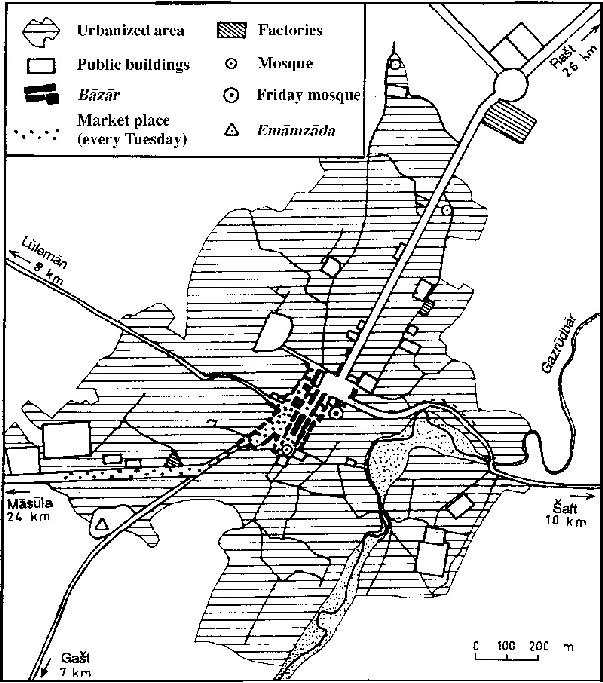
Fūman has gained importance again since the middle of the 20th century as a commercial and administrative center, with a very active Tuesday market and a large tea-processing factory belonging to the State Tea Company (Bazin, 1980, II, pp. 178-79). Its development is still somewhat hindered by the proximity of Rašt, to which it is linked by a heavily trafficked motorway. Its population grew from 9,226 inhabitants in 1966 to 15,108 in 1976, 24,631 in 1986, and 31,341 in 1996, before decreasing to 27,763 inhabitants in 2006 (Markaz-e Āmār-e Irān). A large avenue opened at Reżā Shah’s time leads to a wide square built at the edge of the traditional town core, where the farmāndārī building has taken the place of the former palace of the khans between the Friday mosque and the market (bāzār). The market was rebuilt at the beginning of the 20th century on a regular rectangular plan and is now expanding toward the Māsūla road (Bazin, 1996, pp. 125-26 and Pl. on p. 134).
The district (šahrestān) of Fūman initially included all southwestern end of the Ṭāleš highlands, with 227 villages and some 155,000 inhabitants on 2,370 sq. km in 1329 Š./1950 (Razmārā, Farhang II, p. 202). Since its northern part around Ṣawmaʿa-sarā was established as a new šahrestān in 1963, the Fūman šahrestān was reduced to 1,582 km² and to two subdistricts (baḵš), namely, Ḥūma, including dehestāns of Ḥūma (until 1976 Ḥūma and Kalāšom), Māsūla, and Gašt; and Šaft, with dehestāns of Šaft (formerly Qaṣaba and Jīrdeh), Aḥmad Sargūrāb, and Čowbar. The total population was 123,158 inhabitants in 1966, 144,820 in 1976, and 175, 597 in 1986. The bakš of Šaft was turned into a new šahrestān; and it was completed by inclusion of what formerly had been the northeasternmost part of Ḥūma dehestān. This area, lying on both banks of the Pasikānrūd, received a designation as the dehestān of Mollā Sarā (see ŠAFT, pending). The remaining part of Fuman was divided into two bakš. One bakšwas termed Markazi, and it included the four dehestān of (1) Rūdpīš to the northeast, (2) Lūlemān to the northwest, (3) Gašt and (4) Gūrāb Pas to the south and southwest. The other bakš of Fuman, to the north, formerly was the dehestān of Māsūla (q.v., pending); it was renamed Sardār-e Jangal in honor of the revolutionary leader Mirzā Kuček Kān (q.v., pending). The bakš is comprised of the dehestān likewise named Sardār-e Jangal, which is located in the valley of Māsūlarūd, and the dehestān of Āliān. Within this reduced area, the šahrestân of Fuman had 103,192 inhabitants in 1996 and 97,144 in 2006—a significant decrease of 5.9 percent resulting from losses both in the city (-11.4 percent) and in the mountainous area (-8.5 percent).
The alluvial plain, built up by parallel rivers flowing into the Anzalī (q.v.) lagoon, is thickly populated by Gīlak sedentary peasants, whereas the piedmont and the mountains are more sparsely populated by semi-nomadic Ṭāleš peasants and husbandsmen, all of them Shiʿites.
The plain and piedmont are devoted to rice-paddies irrigated by the Fūmanāt canal derived from the Safīdrūd River through the Tārīk tunnel, tobacco and tea gardens, and mulberry groves used for intensive silkworm breeding. Ṭāleš herders take cattle from the piedmont and sheep wintering on lower wooded hills to extensive summer pastures scattered around the summer market of Māsūla. Many settlements in the mountainous part of the Fūman district suffered damage as a reult of the 20 June 1990 Rūdbār-Manjīl earthquake.
Bibliography
M. Bazin, Le Tâlech : une région ethnique au nord de l’Iran, 2 vols., Paris, 1980.
Idem, “Le Tâleš revisité,” Stud. Ir. 25, 1996, pp. 115-34.
ʿAbd-al-Fattāḥ Fūmanī, Tārīḵ-e Gīlān, ed. M. Sotūda, Tehran, 1349 Š./1970, passim.
A Jaubert, Voyage en Arménie et en Perse, Paris, 1821.
K. Kešāvarz, Gīlān, Tehran, 1347 Š./1968, pp. 88-93.
G. Le Strange, The Lands of the Eastern Caliphate, Cambridge, 1905, pp. 174-75.
Markaz-e Āmār-e Irān, Saršomāri-e ʿomumi-e nofus o maskan [decennial national census], Tehran, 1966-2006.
G. Melgunof, Das südliche Ufer des Kaspischen Meeres, oder die Nordprovinzen Persiens, Leipzig, 1868, pp. 254-60.
H.-L. Rabino, Les provinces caspiennes de la Perse: Le Guilân, RMM 32, 1915-16, pp. 161-208.
Idem, “Rulers of Lāhijān and Fuman in Gilān,” JRAS, 1918, pp. 85-100.
M. Sotūda, Az Āstārā tā Estārbād I, Tehran, 1349 Š./1970, pp. 129-224.