

EXCAVATIONS
iii. In Central Asia
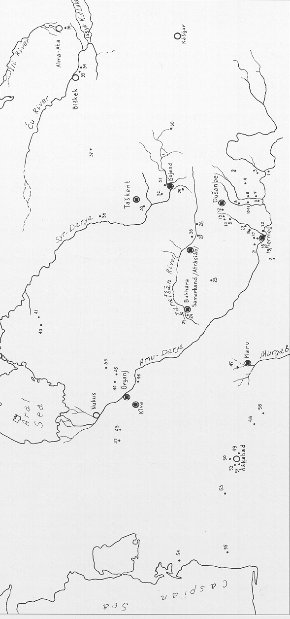
History of Excavations (Figure 1)
Archeological and architectural monuments of Central Asia are mentioned in reports from the 18th and early 19th centuries by European and Russian travelers, merchants, and diplomats. The Russian orientalist P. I. Lerkh, who accompanied a minor diplomatic mission, even undertook small-scale excavations. Major archaeological work began, however, only after the Russian conquest of the region; at first it was done by amateurs, especially military officers. The first professional archaeologist to work in the region was N. I. Veselovskiĭ of the University of St. Petersburg. He undertook minor excavations at several sites in the Tashkent oasis, Farḡāna and, on a larger scale, in Afrāsīāb (q.v.), the site of ancient Samarqand. Seven trenches were dug in different parts of the city, and a plan of the site was prepared. From the extensive finds the site was dated as “going back to the Greek period”; in fact, it has a much longer history. At almost the same time, General A. V. Komarov cut a huge trench through the northern mound at Anaw (q.v.) in southern Turkmenistan.
A subsequent French expedition to Afrāsīāb, directed by E. Blans and M. J. Chaffanjon, achieved little result. V. V. Barthold and his collaborator V. L. Vyatkin had much better results there and at other sites near Samarqand in 1904 and later. By that time Barthold had published his important monograph Turkestan v epokhu mongol’skogo nashestviya (tr. as Turkestan Down to the Mongol Invasion). In the same period, Vyatkin discovered and partly excavated the observatory of Uluḡ Beg near Samarqand.
In 1895 the Turkestan Circle of Amateur Archaeologists was founded in Tashkent. Along with surveys, its members undertook excavations on a small scale, the most important of which were those at Paykand. The most significant archaeological expedition of that period, however, was led by Raphael W. Pumpelly to southern Turkmenistan. Pumpelly, an American geologist famed for his investigations in China and Mongolia, decided, after a survey trip in 1903, to undertake excavations at Anaw and in Marv. The German Hubert Schmidt, a professional archaeologist who had taken part in the excavations of Troy, served as field director. In 1904 two deep trenches were dug along the southern and northern slopes of the northern mound of Anaw (q.v.), and several soundings were made to virgin soil. A number of strata with remains of walls and floors were revealed, and the periods Anaw I and II were distinguished. Trenches were also dug in the southern mound and assigned to the later Anaw III and IV periods. The excavation methods, including the use of soundings, met the archaeological standards of the time. Planimetric and stratigraphic observations were made, plans and sections drawn, a system of relative chronology was established, and materials were collected and published according to stratum. Pumpelly’s expedition was thus a forerunner of the multidisciplinary expeditions which were undertaken three decades later. These excavations resulted in the discovery of the Eneolithic, the Bronze Age, and the Early Iron Age periods in Central Asia, though it was impossible at that time to define the exact chronological limits of these periods. Schmidt also directed work at the site of Gowr Qalʿa (old Marv) but on a smaller scale than at Anaw. Four trenches and some soundings provided an idea of the stratigraphy. As the excavators were not familiar with the written sources on the history of Marv, however, they were unable to interpret the results of their work.
The scientific standard of most archaeological excavations of the late 19th and early 20th centuries was fairly low, even for that time. Only in a few cases (Anaw, Paykand, the observatory of Uluḡ Beg) were some valuable results achieved. At the end of the 1920s, however, the situation began to change. Professional archeologists began to supersede amateurs. In 1926-28 the Museum of Oriental Cultures in Moscow sponsored an expedition to southern Central Asia under the direction of B. P. Denike which worked in Central Asia, mainly in the south. A number of Buddhist sites were discovered near Termeḏ (Termez), and the palace of the 11th century rulers was partly excavated. The first scientific investigations of kurgans and settlements dating from the 3rd/2nd centuries B.C.E. to the 6th/7th centuries C.E. were carried out in Kirgizia, in the region of Tashkent, and in Fergana. Smaller excavations were undertaken at medieval sites in Chorasmia (q.v.). At Aïrtam west of Termeḏ the discovery of a Buddhist sculptural frieze and the beginning of excavations by M. E. Masson revealed Kushan materials in Central Asia, and excavations at Nisa by A. A. Marushchenko and S. A. Ershov) established the presence of Parthian culture in the same region. At Mt. Mug; in the upper Zarafšān (Zeravshan) valley, a Sogdian castle from the beginning of the 8th century was excavated by A. A. Freĭman in 1932-34, and for the first time Sogdian manuscripts were discovered in Sogdia itself; there were also Chinese and Sogdian coins and manuscripts in Arabic.
In the later 1930s several large multidisciplinary expeditions were organized. In 1936-38 the Termeḏ expedition, under Masson’s direction, continued investigations of the ancient and Islamic periods in and around that site in ancient Bactria (q.v.). In addition to continuing work at the 11th century palace and the Buddhist shrine at Aïrtam, participants investigated a Buddhist cave monastery at Qara Tepe and the ancient irrigation system. Stone age sites were also explored. In the Sorḵān Daryā district of Uzbekistan, A. P. Okladnikov explored the cave of Tešik Taš where he discovered a burial of a boy dating to the Mousterian period.
Two large expeditions started work simultaneously in the northern part of Central Asia, the Semirech’e and the Chorasmian expeditions led by A. N. Bernshtam and S. P. Tolstov respectively. The former excavated burials of ancient nomads and several important early medieval sites at Aq Bešim, Krasnaya Rechka, and Qïsmači. In addition, the main periods of development in Semirech’e between the mid-2nd millennium B.C.E. and the 15th century C.E. were defined. The Chorasmian expedition investigated sites that date from the Neolithic through the medieval periods and especially of the Kushan period (see CHORASMIA i).
The Chorasmian team continued to work after World War II. From the 1940s into the 1980s it excavated many important sites around the Aral Sea: the Neolithic settlement of Janbas Qalʿa and the Tumek-Kičijik burial grounds; the Bronze Age Kokča III burial grounds and the early tombs at Tagisken; burials of the Saka tribes at Uygarak, Tagisken, and elsewhere; fortresses and settlements of the 6th-4th centuries B.C.E. at Güzeli Gïr (Kyuzeli Gyr), Qalʿali Gïr (Kalaly Gyr), Qoy Qrïlgan Qalʿa (Koi Krylgan Kala), Dingilje, and elsewhere; similar remains from the pre-Kushan and Kushan periods, especially Topraq Qalʿa; the Afrighid (see ĀL-E AFRĪḠ) castles of the Berqut Qalʿa oasis; and such Islamic sites as Hazārasp. These excavations yielded information on irrigation, city planning, architecture, fortifications, material culture, art, burial customs, and religion. Samples of Chorasmian writing were discovered, particularly in the archives of Topraq Qalʿa and on Chorasmian coins. The finds constituted a major contribution to the study of the political and ethnic history of ancient Chorasmia. Among the specialists taking part in the excavations were B. V. Andrianov, B. I. Vaĭnberg, A. V. Vinogradov, O. A. Vishnevskaya, M. G. Vorob’eva, M. A. Itina, L. M. Levina, E. E. Nerazik, Yu. A. Rapoport and L. T. Yablonskiĭ.
After the war, the Semirech’e expedition was divided into two parts, the Southern Kazakhstan and the Tien Shan-Alai (later Pamir-Farḡāna) expeditions, both under Bernshtam’s direction. For the first time Bronze Age monuments of the steppe tribes and settled peoples were uncovered in the Tien Shan mountains, the Farḡāna and Alai valleys, and the eastern Pamirs. Kurgans of the Saka tribes containing objects executed in the “animal style” were also discovered in the Eastern Pamirs.
The Southern Turkmenistan Archaeological Multidisciplinary Expedition, directed by M. E. Masson from 1946, was a completely new enterprise. It included specialists on the Stone Age; among its discoveries was a Neolithic cave at Jabal (Okladnikov). At the end of the 1940s the expedition turned to Namāzgāh Tepe, the most important Bronze Age site under the direction first of B. A. Litvinskiĭ and later of B. A. Kuftin. For the next forty years a whole series of Eneolithic, Bronze, and Iron Age sites were excavated in southern Turkmenistan by V. M. Masson, V. I. Sarianidi, and I. N. Khlopin. At Parthian Nisa large monuments were uncovered, and luxury objects like ivory rhyta, clay and stone sculptures, and metalwork, as well as numerous Parthian ostraca were found (M. I. Vyaz’mitina, E. A. Davidovich, and S. A. Ershov). From excavations in different parts of the vast site of Old Marv it was possible to establish its stratigraphy and to outline its history from the early Iron Age to the 15th/16th centuries C.E. and to assemble a major collection of terra-cotta figurines and other objects. Buildings connected with Buddhist and Christian cults were also discovered (G. A. Koshelenko, S. B. Lunina, O. V. Obel’chenko, Z. I. Usmanova). Among medieval sites the most noteworthy was Šahr-e Eslām, the historical Yazïr (Litvinskiĭ). Islamic architectural monuments were studied by G. A. Pugachenkova.
The Sogdian-Tajik expedition (directed successively by Yakubovskiĭ, later by M. M. D’yakonov [q.v.], and A. M. Belenitskiĭ) began work in Central Southern Tajikistan in 1946. The next year it opened the site of Panjikant (Panjikent) in the Zarafšān valley, where annual excavations still continue. In the first seasons two temples, city fortifications, main streets, and patrician houses with two or three stories and many rooms were uncovered. The citadel and suburbs of the town were also excavated, and Zoroastrian burials were found in the latter. The site has also yielded walls and carved wooden panels. The outlines of the 7th-8th century Sogdian town were thus established; earlier strata were excavated in subsequent seasons. Among participants in these excavations were O. G. Bol’shakov, B. Ya. Staviskiĭ, and A. I. Terenozhkin. In southern Tajikistan (northern Bactria) , Qalʿa-ye Mīr, Kay Kobāḏ Šāh, Munčaq Tepe, and the necropolis at Tūp Ḵāna were excavated, permitting identification of the main phases of Bactrian civilization .
In the 1940s and 1950s all the Central Asian republics instituted national academies of science, including archaeological departments. In 1970 an institute of archaeology was founded in Uzbekistan. In the decades since 1950 excavations have also been conducted by these centers and museums jointly with academic institutions in Moscow and Leningrad/St. Petersburg, both within the framework of the aforementioned expeditons and in totally new projects. At the end of the 1980s and especially in the 1990s western European, American, and Japanese archeologists also began to take part in excavations in Central Asia.
MAJOR SITES AND DISCOVERIES BY PERIOD
Archeological excavations of Central Asian sites have yielded artifacts from all historical eras:
Lower Paleolithic (800th—200th millenniums): From this era dates the most ancient site in Central Asia, Kul’dara (southern Tajikistan), buried 120 m deep under loess. The oxygen paleoclimatic scale indicates that it is 800 thousand years old. Small stone tools found there show signs of shingle technology and can be considered early examples of the Qara Tāūs shingle culture.
Middle Paleolithic (200th to 40th millenniums): The principal sites are Teshiq Taš, Āb-e Raḥmat; (Uzbekistan), Qara Bura, Obzi Kičik (Tajikistan), Georgievskiĭ Bugor (Kirgizia). The stone tools found at these sites show a degree of standardization lacking in the artifacts from the previous period. Finds include triangular wedge-blades, pointed tips and scrapers. Mousterian industry was probably brought to the region from the west by the Neanderthals, who were of a different physical type than the local inhabitants. A burial of a Neanderthal boy was discovered in the grotto of Teshiq Taš.
Upper Paleolithic (40th to 10th millenium): According to archeological data, the Upper Paleolithic developed through the autochthonous evolution of Lower Paleolithic indigenous industry. Notable sites of the period are at Samarqand and Šugnow (Tajikistan). At the early phase of the Upper Paleolithic, Mousterian technical traditions are still in evidence. Knife blades, characteristic for Europe and the Near East, appear only at the latest phase. No cutting tools from the Paleolithic have been found in Central Asia. Tools display signs of having been reworked.
Mesolithic (10th to 6th millennium B.C.E.): This period is characterized by two lines of development. One group of sites (which should be designated as Epipaleolithic) followed the tool-manufacturing traditions of the Upper Paleolithic (Oœḵona [Āœḵāna] in Tajikistan, Āb-e Šīr in Uzbekistan). Tools of geometric shapes were not found there. The principal group of sites (Mesolithic proper) yielded a large inventory of tools with geometric shapes (trapezoids, segments, triangles, etc.) This development was probably brought about by the second wave of migrations from the Near East. Yet in Central Asia there were still no signs of a transition to a sedentary way of life and a production-oriented economy, which were in evidence in the Near East.
Neolithic (6th to 4th/3rd millennium B.C.E.): Three distinct Neolithic cultural communities left their traces in Central Asia: in the west, along the foothills of the Kopet Dag was the early agricultural Jeytūn culture; in the desert regions of northern Central Asia lived the hunters and fishermen of the Kaltaminār culture; the Afghan-Tajik depression and the mountain regions of eastern Central Asia were inhabited by the tribes of the Ḥesār (Hissar) culture. The Jeytūn culture (Jeytūn, Čagallï Tepe, Čopan Tepe, Bami, etc.) went through three stages of development. In all settlements there were houses built of adobe and flat rectangular bricks. They were square and had a single chamber with a hearth, as well as a yard where sheds were located. Sometimes such structures formed extensive complexes (Chagallï Tepe). Their floors and walls were covered with clay or alabaster plastering, sometimes they were painted and decorated. The necropolises were situated inside the settlements. Archeological finds include stone tools, reaping hooks with flint bushing, and some painted pottery. The economy was based on agriculture, stock breeding, and hunting. Middle Eastern traditions played a considerable role in the cultural genesis, along with the local traditions. The Kaltaminār culture (Janbas 4, etc.) was characterized by communal dwellings with frame structures built with wooden pillars, rafters, and reed roofs. Semi-dugouts were also found. Kaltaminārians had resort to all technologies of the developed Neolithic. Their pottery was of ovoid and semi-spherical shapes. Grave goods included decorations made of shell and bone (the necropolis in Tumeq-Kičijik), datable to the 4th-3rd millenium B.C.E. and with two stages of development. Ḥeṣār represents the most ancient and isolated of the cultures.
Neolithic: The Central Asian Eneolithic period is represented by numerous sites in southern Turkmenistan (Anaw, Namāzgāh Tepe, Kayšut, Čaqmaqlï Tepe, Yalangač Tepe, Qara Tepe, Dašlaji Tepe, Göksür, Altïn Tepe etc.). Settlements were small and medium in size; the latter were usually oasis centers. Some larger settlements covered an area of ten to twenty hectares or more. Early settlements consisted of rectangular or oval single-chamber houses heated by hearths. Later, larger housing units appeared. Necropolises held both single and collective tombs, with up to ten burials in one site. Some burial sites contained rich grave offerings. The economy was based on irrigation agriculture. Considerable progress was made in the manufacture of tools, utensils, and jewelry. There were temples where a cult fire was lighted; finds of small figurines suggest worship of a female deity. Pottery ornamentation also had cult significance. Possible dates for these sites would be the fifth to third millennium B.C.E.
The Bronze Age. During the Bronze Age (end of the third to the beginning of the first millennium B.C.E.), southern Turkmenistan was still settled by tribes practicing primitive agriculture. The rest of Central Asia was inhabited by tribes pasturing on the steppes. However, this division was not absolute. In some regions of Sogdiana there were settlements of primitive farmers. Around the middle of the 2nd millennium B.C.E. sedentary agricultural tribes migrated to southern Tajikistan and southern Uzbekistn and lived there alongside the local nomadic pastoralists.
Numerous Bronze Age settlements have been discovered in southern Turkmenistan (Anaw, Aq Tepe Altïn Tepe, Qara Tepe, Teqem Tepe etc.). Smaller settlements covered areas of about 0.5-1 hectare, medium ones spread out about 10 hectares. The ruins of Namāzgāh Tepe, the largest settlement of the Bronze Age in Central Asia and Persia, cover 70 hectares. The site was inhabited since the Neolithic period. Many of the excavated structures were large houses with nine to twelve rooms. Altïn Tepe (q.v.) is an oval archeological site of 26 hectares founded in the Eneolithic period. During the Bronze Age this settlement was surrounded by fortification walls 5 m thick, and reinforced with towers; pylon gate-towers decorated with pilasters guarded the entrance. Most of the settlement’s territory was taken up by dwellings. Houses had an enclosed architectural layout and consisted of chambers connected by a system of passages. Each complex contained both living quarters and storage space. Yards and kitchens were often shared. The trades and crafts, especially metalworking and pottery, were concentrated on “the artisans’ hill.” In Altïn Tepe there was a religious center with a monumental cult complex probably dedicated to the worship of astral and lunar deities; the tombs of priests richly endowed with grave goods were also found there. Some investigators hold that Altïn Tepe, which dates from 2300-1850 B.C.E., was not just a settlement but a proto-city similar to the most ancient urban centers of the Middle East. A primitive-agricultural economy prevailed also in the oasis of Marv, and in south-western Turkmenistan in the region of Dehestān.
The steppe bronze cultures of Central Asia—the Tāza Bāḡ Yāb (Tazabag’yab) culture in the Aral region, the Qara Qum and other cultures in the Farḡāna district—developed in the steppe and mountain regions of the Andronov cultural zone. Steppe settlements consisted of primitive structures, sometimes semi-dugouts, with a hearth in the center. They were inhabited by sedentary tribes engaged mostly in primitive agriculture and cattle-raising. Mining and metalwork were also practiced, producing a variety of bronze artifacts. Pottery finds are cruder than the ceramics of southern Turkmenistan, with stamped or engraved geometrical ornaments rather than painted decorations. In some oases of the eastern zone there were centers of ancient-agrarian culture, such as Sarazm and Zamān Bābā in the Zarafšān valley.
During the first half of the second millennium B.C.E. the primitive agrarian tribes of southern Turkmenistan started migrating eastwards, to northern Afghanistan, southern Uzbekistan and Tajikistan. Since the ecological conditions of Tajikistan were not favorable for irrigation agriculture, the migrants turned to pasturing. Living in close contact with the local steppe tribes, they adopted many aspects of their way of life and burial rites. In southern Uzbekistan the migrants preserved their way of life, founding fortified settlements like Sapalï Tepe, or large settlements like Jarkutan with a “palace,” a temple, and a large necropolis. During the second half of the second millennium B.C.E. some steppe tribes started migrating south, entering the zone of primitive agriculture. Many scholars connect this movement with the migration of the Indo-Aryans and the settling of proto-Iranians in Central Asia.
Early Iron Age. In Central Asia the Iron Age began in the 9th-8th centuries B.C.E—later than in the Middle East and Persia. Yaz Tepe in Margiana (Marv) is one of the best researched sites from that period. The Yaz Tepe settlement, which covered about sixteen hectares, consisted of a settlement mound with a citadel at the top. The citadel, surrounded by a defensive wall, enclosed a large monumental structure built directly on the platform. This might have been a palace consisting of long parallel halls and small square chambers, connected by passageways. The platform and the building itself were made of adobe. The building was completed in two stages sometime between 950 to 650 B.C.E. Other settlements have been discovered in southern Turkmenistan (Anaw IV, etc.), and in Bactria (Kučuk Tepe in southern Uzbekistan). The central part of the Kučuk Tepe settlement—the so-called citadel—looked like a flattened circular hill with an area of 0.5 hectares. The early structures were built on a clay platform surrounded by a defensive wall. During the first phase of construction the building in the citadel consisted of three large parallel rectangular rooms connected by passageways and one narrow room. At the end of the first period (tenth to mid-eighth centuries B.C.E.) the building at Kučuk Tepe had twenty-five chambers; apparently this was a large fortified house. Towns start appearing in the region towards the end of that period. Diverse indigenous cultures developed in Farḡāna, southwestern Turkmenistan (Mašhad-e Meṣrīān plateau) and in the area around the Aral sea (Chorasmia).
Archaeology of the Achaemenid period. The Achaemenid state, which emerged in western Persia in the middle of the sixth century B.C.E., soon subdued the principal regions of Central Asia. By that time in Central Asia there were large cities such as Bactra (Balḵ), Marv, and Samarqand. Their formidable defensive installations and some buildings have been studied in detail. Qïzïl Tepe is the site of a medium-sized urban center in the Sorḵān Daryā region. It was a rectangular fortified town of about 30 hectares with a citadel. The buildings of the settlement extended all the way to the city walls, which measured 10 meters thick at the base. Other towns consisted of an unfortified settlement built around a citadel.
More cities have been excavated in Chorasmia. One of them, Güzeli Gïr (sixth to fourth centuries B.C.E.), was a semi-triangular fortress extending one kilometer from north to south. The city wall had an inner gallery. The citadel enclosed a huge architectural complex. The central part of the city consisted of dwelling compounds, some of the courtyard type. Another large city in Chorasmia is Qalʿali Gïr (1000 x 700 m). It was defended by a wall with towers. The excavations uncovered a square palatial building with two inner courtyards. The roof was supported by columns. Some of its architectural features recall the palace of Xerxes at Persepolis. The fortress and palace are attributed to the end of the 5th or the beginning of the 4th century B.C.E. The circular sacral building at Qoy Qrïlgan Qalʿa was built in the 4th century B.C.E.
In the cities manufacturing industries were well developed, including the production of commercial goods. In the rural areas crafts took a domestic character. Along with the manufacture of tools, weapons and utensils, finely crafted jewelry and luxury items were also produced (gold, silver and ivory finds in the temple of Oxus and the Oxus treasure). During the Achaemenid period artifacts and weaponry made in Athens, Corinth, and other Greek centers started finding their way to Central Asia; such objects have been discovered in the Oxus Temple.
Archeology of the nomadic tribes. Information obtained from ancient Persian, Greek, Chinese, Syrian, Armenian, Arabic, and other sources, as well as from the Iranian epic and from linguistic material, show clearly the important role played by Central Asian nomads in the history of the region and its adjacent territories, in terms of both ethnogenesis and culture. The archaeology of the nomads explores mainly their kurgans. Kurgans of the Saka tribes, dating from the seventh to third centuries B.C.E., can be found in the Semirech’e region (also known as the Yeti Su, “seven rivers”), the Aral region, in Fergana, etc. The burials were usually single, sometimes dual, rarely collective. In the Pamir region, the corpse was often buried in a flexed position. The form and structure of burial sites varied. Most often they consisted of a pit covered with beams, on top of which was piled a rounded mound or erected a circle of stones. The “royal kurgans” at Bešatïr in the Semirech’e had a different construction. The body was placed in a wooden surface structure, which was then buried under a huge mound of gravel (presently, the mounds do not exceed 100 m in diameter and 17 m in height). In the richer burials the body was dressed in leather attire lavishly adorned with golden plaques. The kurgan of İssïk (Alma-Ata) yielded about five thousand golden ornaments and a golden head-dress. The Saka of Central Asia were highly skilled artisans, who produced beautiful ornaments shaped like animals. The kurgans of Bešatïr and the Pamirs have yielded sacrificial cauldrons, often richly decorated, and sacrificial tables. The religion of the Saka was related to the Iranian religions and was centered on the cults of the fire and the sun.
In the northern regions of Central Asia the Saka were eventually replaced by the Wu Sun and burial rituals consequently changed. First podbois (grave pits with burial niches on the long side) appeared, then catacomb burials. In some valleys (Ketmen Tübe in Kirgizia, Biškent in Tajikistan, etc.) thousands of nomadic graveyards have been discovered. The Farḡāna valley was inhabited mostly by semi-nomadic tribes. The archaeology of nomads from different epochs (including Turkic tribes from the seventh to ninth centuries C.E.) has been thoroughly investigated.
Archaeology of the Hellenistic states. The Greco-Bactrian and the Parthian kingdoms emerged in the southern regions of Central Asia around the middle of the third century B.C.E. The Greco-Bactrian kingdom soon occupied the entire territory of present day Afghanistan and parts of northern India. In Central Asia its dominion encompassed southern Tajikistan and Uzbekistan, at times spreading to the Zarafšān valley (Sogdiana). Its most representative archeological site is the Oxus Temple (Taḵt-e Sangīn) in southern Tajikistan. The temple was situated at the confluence of the Vaḵš and Panj rivers. It consisted of a central hall (12×12 m) with four pillars. The hall was surrounded on all sides by two sets of corridors. The eastern entrance to the central hall opened onto a pillared portico, which was flanked by two extensions. Each extension had three enclosures, one of which housed a fire altar made of adobe. A sacred courtyard surrounded by a wall was situated in front of the building. All the walls of the temple were made of unfired bricks. The pillars and thresholds were made of stone; there were also Hellenistic stone altars. The architectural design of the temple shows obvious signs of Oriental and Greek cultural synthesis. The temple’s layout and a preserved Greek inscription testify that it was a place of worship dedicated to the cults of fire and water. Its treasury contained numerous artifacts made of gold, silver, bronze, ivory and alabaster; other finds include about five thousand items of household goods and weaponry, portraits of Alexander the Great and of the Greco-Bactrian kings, a battle scene between the armies of Greeks and Persians, and other works of art dating from the pre-Hellenic and post-Hellenic periods (the temple was built towards the end of the fourth and the beginning of the third centuries B.C.E.). Interesting monuments of the Greco-Bactrian era have been discovered in Termeḏ and in other places.
The Parthian kingdom, which existed for more than half a millennium, started expanding soon after its emergence. Parthian armies conquered Persia, then Mesopotamia and some adjacent territories. Nisa, the most notable Parthan site in Central Asia, was located near present-day Ashkhabad, the capital of Turkmenistan. Nisa consisted of two urban complexes: Old Nisa and New Nisa. The latter was founded in Parthian times and continued to develop during the Middle Ages. Most explorations, however, have been carried out on the site of Old Nisa. They have uncovered fortifications and a few complexes of monumental structures, among them a large square building and adjacent wine store-house; a building with a square hall; a tower-like structure; a building with a round hall, etc. The square hall building is an imposing structure measuring 20×20 m on the inside. It had four pillars of baked brick in the center. The interior was decorated with 24 pilasters around the walls, and with an upper tier of niches where clay statues were placed. The excavations uncovered magnificent Parthian artifacts, murals, stone and clay sculptures, metal figurines, ivory rhyta, and an archive of Parthian ostraca. Manṣūr Tepe and some other Parthian settlement sites yielded additional architectural material and artifacts.
Kushan and post-Kushan archaeology. Many towns and settlements from the Kushan period (first century B.C.E. to third century C.E.) have been discovered on the territory of Bactria, among them Aïrtam, Dal’verzin Tepe, Zar Tepe, Yavan, Kay Kobād Šāh, Khalchayan, Seksen Āḵor, etc. One of the biggest urban centers was Termeḏ (Tarmita of ancient Indian sources). Dal’verzin Tepe (q.v.), a fortified town with a citadel, has been studied in detail. It had streets, multi-chamber manors for the rich patricians, dwellings for commoners, and artisans’ quarters where fine pottery was produced. The town had functioning cult complexes and Zoroastrian burial installations. Interiors were decorated with wood carvings and murals. Wall-paintings were found in Seksen Āḵor; a cycle of murals and sculptures were discovered in a richly decorated palace in Khalchayan. The site at Zar Tepe had better defined town-planning than the one at Dal’verzin Tepe. Zar Tepe covered a square area of sixteen hectares. The town was defended by fortification walls flanked by semi-circular towers; a citadel was located in one of the corners. A wide thoroughfare passed through the town square. The city had several temples. Walls were usually made of unfired bricks; stone was used for pillars and pilasters, as well as for high relief friezes. There was a variety of burial rituals: kurgans and ground graves, interment of bones in ossuaries, burials in abandoned buildings, etc. There were even a few cases of burials in anthropomorphic clay coffins, obviously associated with the migrations of the Parthians. Agriculture was highly developed; a wide network of irrigation canals was discovered in the area. The crafts were also well represented, especially pottery; it produced high quality household utensils and cult figurines. The manufacture of metal tools and weapons, wood-work, leather goods, jewelry, glass-ware, etc. indicated a thriving economy. Also, many artifacts were acquired through trade or as war-booty (the golden treasure of Dal’verzin). The script used became known through epigraphic finds like the Kushan letter from Aïrtam written in the Bactrian language. The Buddhist monasteries in Qara Tepe and in Fayyāż Tepe near Termeḏ yielded numerous inscriptions in the Indian languages, written in KharosÂṭī and Brāhmī script. Bactrian and bilingual inscriptions were also found there.
Many monuments of the Kushan period have been discovered and investigated in Chorasmia, although Chorasmia itself was not part of the Kushan kingdom. The capital city at the site of Topraq Qalʿa was studied in great detail. It consisted of five parts: (1) The city proper. It was comparatively small (350×500 m), but well fortified, with a defence wall, towers, and a moat. A central thoroughfare divided the city in two parts, segmented further by side streets. A fire temple stood somewhat apart from the housing sections. (2) The citadel. (3) The high palace, located in the citadel. (4) The palace-temple complex beyond the city walls. (5) A rectangular area surrounded by embankment. The high palace was situated on a platform with 102 rooms at its center. The layout of this massive structure was very complex, made up of square and rectangular halls and chambers. Niches held clay statues; the walls were covered with murals. The throne-room was richly decorated. The palace held an archive, which included many documents in Chorasmian. A second palace, built beyond the city walls, was not so well preserved; its interior was also decorated with murals and statuary. The palace complex and the documents date back to the 2nd-3rd centuries. At that time ossuary burials were already practiced in Chorasmia. Some of the ossuaries had anthropomorphic shapes.
The most important cultural centers in Sogdiana during the late Parthian and early Sasanian period were Afrāsīāb (Samarqand) and Yer Qurgan (Qaška Daryā). In contemporaneous Margiana, cultural life continued to be centered in Marv. During the post-Kushan period (3rd-5th centuries) urban development and the evolution of material culture continued as before, but the general situation, particularly nomadic intrusions, led to the decline of some regions.
Archaeology of the cities and palaces of the early Middle Ages (5th-8th centuries). This is one of the most successful fields of Central Asian archaeology. Among the investigated sites are some of the largest urban centers of the region: Marv, Afrāsīāb, Tashkent, Bukhara, as well as numerous medium-sized towns: Panjikant, Varaḵša, Kāfer Qalʿa, Qalʿa-ye Qahqaha II (Kalai Kakhkakha), etc. Panjikant can serve as a representative site. The town consisted of a šahrestān or inner city, with an area of around twenty hectares, a separately located citadel, and suburbs. The excavations of the fortified šahrestān show that it was divided into quarters by streets, which were lined on both sides with dwellings, store-houses, and artisan workshops. More than two hundred multi-chamber houses, workshops, stores, etc. have been excavated so far. About one-third of the houses belonged to patricians or affluent citizens; their reception halls were decorated with several tiers of murals or carvings. Two adjacent temples were accorded a special place in the town-planning scheme. The palace of the ruler was situated in the citadel. In Samarqand, on the site of Afrāsīāb (q.v.), which was the capital city of Sogdiana, excavations uncovered a ruler’s palace with remarkable murals. Another palace, found in Varaḵša, was decorated not only with murals but also with intricate alabaster stucco panels and alabaster sculptures. This palace was the residence of the Boḵār-ḵodāt, the ruler of Sogdian Bukhara. In Oœrūsana, in the eastern reaches of Sogdiana, the residence of the ruler (afšīn, q.v.) was located on the site of Qahqaha II (present-day Šahrestān). Excavations have uncovered part of the šahrestān and also the palace in the citadel, decorated with objects of art. In Ṭoḵārestān, southern Central Asia, archeological investigations have been conducted in the city of Kāfer Qalʿa (in Tajikistan), where the palace in the citadel and the buildings of the šahrestān have been fully excavated.
In all parts of Central Asia there were fortified castles, some of which served as residences of rulers and powerful nobles (Balalïq Tepe, Jumalaq Tepe, Jar Tepe, Qalaʿ-ye Qahqaha I, Orta Qurgan, etc.). Many rural castles are to be found in Chorasmia, especially in the Berqut Qalʿa oasis. They were often two-tier structures built on a high platform. Mountain castles were usually located on isolated cliffs (Mt. Mug, etc.). The halls in the castles were decorated as richly as those in the palaces.
Architecture and construction techniques demonstrate a high degree of sophistication. Construction was guided by drawings. Walls were built mostly from adobe, which was also used for the construction of arches, vaults and domes. Interiors were richly decorated. Murals depicted epic heroes and battles, deities, banquets and scenes from everyday life. There were also compositions of high and low relief, as well as sculptures. Temples were decorated just as lavishly. Information on weaponry, attire, fabrics, jewelry, metalwork, and pottery has been obtained from archeological finds and from mural paintings.
Ossuary burials were widely practiced in Chorasmia and Sogdiana, as well as in the Tashkent oasis and the Semirech’e region. The bones of the deceased were first freed from all soft tissue, then placed in an ossuary made of stone or terracotta. Ossuaries were kept in special chambers. This ritual was based on a Central Asian version of the Zoroastrian religion. Iconographic material, linguistic data, and archeological finds of sacral objects suggest that this religion had a wide following among the local inhabitants. Ossuaries were often richly decorated with beautiful reliefs, carvings or paintings; sometimes they were engraved with inscriptions. The iconography of the ossuaries had a religious significance. Along with Zoroastrianism, religions like Buddhism, Manicheanism and Christianity also had a following in the region.
Written documents have been found on a number of sites (Afrāsīāb, Šahrestān, Panjikant). Most important among them is the archive from Mt. Mug. It contains eighty documents—letters and other epistles of an economic or diplomatic nature, some written in Arabic, most in Sogdian .
Buddhist archaeology. Buddhist sites started developing in northern Bactria during the first century C.E. The cave monastery at Qara Tepe in old Termeḏ dates from the first to second centuries; parts of it operated until the fifth century. Apparently, this monastery consisted of fifteen to twenty religious complexes. Seven entire complexes have been excavated to date (1997), as well as two caves which were part of other complexes. Each complex consisted of a grotto and surface structures with court-yards, stupas, etc. The monastery was decorated with Buddhist murals and sculptures made of stone and alabaster. More than a hundred inscriptions in the Indian languages have been found on vessels, as well as a few Bactrian inscriptions and one in an unknown script. Arabic and Middle Persian graffiti on grotto walls probably date from the time of the partial or full abandonment of the monastery. On the plain not far from Qara Tepe lay the ruins of Fayyāż Tepe, another monastery which consisted of three adjacent rectangular courtyards with building complexes. The temple complex was situated in the central courtyard. Gilded murals adorned the sanctuary. The circular stupa was situated outside the courtyard. Excavations uncovered stone, alabaster, and clay statuary, as well as Indian and Bactrian inscriptions. Other Buddhist monuments from the Kushan and post-Kushan periods were found in Termeḏ. Two Buddhist sanctuaries were excavated in Aïrtam (25 km away from Termeḏ). The entrance to one of them was decorated with stone friezes in high relief, depicting musicians. This is one of the best Gandharan works of art. During the second to third centuries Buddhist religious centers functioned also in Zar Tepe, Dal’verzin Tepe, Oštor Mollā, etc. Buddhism set deep roots in Margiana as well; the Buddhist monuments found there date from the third to fourth (or the second to third) centuries.
Buddhist monuments from the early Middle Ages also have been studied in the southern regions of Central Asia. The most important one is at Ajina Tepe (q.v.), a monastery with two courtyards, constructed according to the four-ayvān plan. A star-shaped stupa and numerous other stupas and sanctuaries are to be found in the central part of the temple complex proper. The two-story monastery section contains the main sanctuary, a saṅgha congregation hall, monastic cells, etc. The walls and vaults of the monastery were covered in Buddhist murals, niches and pedestals held clay statues (more than five hundred works of Buddhist art), among them a 12 m statue of the Buddha in nirvana.
Buddhist sites have also been discovered in southern Tajikistan (Qalʿa-ye Kāfernegān, Kāfer Qalʿa, Ḵešt Tepe and the later part of Oštor Mollā). Among the important Buddhist finds in southern Uzbekistan are the Buddhist manuscripts of Zang Tepe. Well-preserved Buddhist manuscripts have been discovered also in the ruins of old Marv. Buddhist monuments have been excavated in Farḡāna (Qobā) and in the Semirech’e region (i.e. Aq Bešim in Kirgizia). Buddhist sites dating as late as the thirteenth century, have also been found in Central Asia.
The study of Buddhist monuments in Central Asia demonstrates that the original models of Buddhist religious installations such as the vihara, saṅghārāma, stupa, etc., were gradually adapted to local construction techniques and building materials. While Buddhist art remained one of the important components of Central Asian art and architecture, there was a considerable interaction between the major cultural traditions in that region. Written sources, including epigraphic, historical, and archaeological material allow us to draw conclusions about the character and dissemination of Central Asian Buddhism, and about its influence on the culture and ideology of the Islamic period, which was to follow.
Archaeology of the Islamic Period. Archeological investigations of Muslim sites in Central Asia have achieved significant results in several fields: (1) Study of the historical geography of Central Asia. Scholars like Guy La Strange, Josef Marquart, and Vasiliĭ Vladimirovich Barthold mapped out the general picture of the medieval historical geography of the region through the use of written sources. However, many small, medium, and even large urban centers and settlements which were mentioned in a variety of documents, remained unidentified; the direction of some trade routes was also unclear. Such sites were precisely located in the territory of Central Asia through surveys, aerial photography, and archeological investigations. (2) Urban life in the Islamic period. Excavations of towns from the Islamic period (Marv, Samarqand, Bukhara, Termeḏ, Tashkent, Ḵojand, Ūrganj, Ḵīva, Aḵsīkaṯ, Qobā, Holbok, Dehestān, Ṭarāz, Otrār, etc.) yielded considerable information on the structure of the major urban centers, on city planning, monumental structures and housing, public services and utilities including water-supply, urban fortifications, demographics and dynamics of development. It was discovered that the structure šahrestān (inner city), qohandez or ark (citadel), and rabazµ (suburbs, outer city) was not uniform for all medieval towns. Many urban centers had no citadel; others had not just one but two šahrestāns. Excavations on urban territory revealed the character, planning, construction techniques, and architectural layouts of many buildings—from monumental ones to ordinary housing, as well as the location of the industrial sections (artisans’ quarters) and the network of city streets. This allowed investigators to determine the density of urban construction in many medieval cities, and to draw conclusions about the size of their population, based in part on interpolation with data about family size and housing from the nineteenth and twentieth centuries. (3) Study of Islamic architecture. Architectural surveys of the most important preserved archeological monuments of Central Asia was supplemented with archeological excavations, which clarified their history, architectural planning, and construction techniques. Such studies were conducted on architectural ensembles, individual mosques, madrasas, mausoleums, and minarets at Samarqand, Bukhara, Ḵīva, Tashkent, and other cities. Some previously unknown sites, like the Ghaznavid palaces in Termeḏ and Holbok, where discovered through such excavations. These sites yielded entire cycles of alabaster stucco wall-panels with magnificent geometric, floral and epigraphic design, some sculptures of animals, and—in Holbok—some excellent paintings of guards, musicians, etc., which continue the traditions of pre-Islamic art. (4) Medieval crafts and manufacture. Archeological excavations have recovered workshops with artisan implements and tools. The manufacturing process of many items was reconstructed through scientific methodology and analysis. Such investigations helped outline the manufacturing repertoire of each major region as well as its evolution. The production of pottery, its basic forms, ornamentation, and glazing have been studied in minute detail. Much attention was given to the production of jewelry and of glass objects such as dishes, glass medallions, or window panes. The manufacture of metal objects was quite diverse and included weaponry, tools, household items, and utensils. Archeological excavations have yielded large collections of beautifully crafted bronze vessels with distinctive designs that set them apart from the artifacts of neighboring regions. (5) Mining and production of metals. Archeological investigations directed at uncovering ancient mines, metallurgical centers, and miners’ settlements have been conducted in association with geological surveys of some regions. The history of particular mines like the famous Kān-e Manṣūr or miners’ settlements (Bāzār Dārā in the eastern Pamirs, situated at 3,900 m above sea level) has also been studied. Archeological data on mining technology, ore dressing, and smelting led to tentative assessments of the production volume of ores and metals; it has also given a clearer picture of the dynamics of the mining process.
Archaeology has provided important information on the development of Central Asian irrigation agriculture, especially in the Aral region and southern Tajikistan. Discoveries of coins from different epochs advanced the development of Central Asian Islamic numismatics. The discovery of human skeletons assisted paleo-anthropology.
See also ARCHAEOLOGY v. PRE-ISLAMIC CENTRAL ASIA; ART IN IRAN vi. PRE-ISLAMIC EASTERN IRAN AND CENTRAL ASIA.
Bibliography
F. R. Allchin and N. Hammond, eds., The Archaeology of Afghanistan from Earliest Times to the Timurid Period, London, New York, and San Francisco, 1978.
E. V. Antonova, Antropomorfnaya skul’ptura drevnikh zemedel’tsev Peredneĭ i Sredneĭ Azii (Anthropomorphic sculptures of the ancient agriculturalists from Central Asia and the Middle East), Moscow, 1977.
A. Askarov and T. Shirinov, “The ‘Palace,’ Temple, and Necropolis of Jarkutan,” in C. A. Bromberg and B. A. Litvinskiĭ, eds., The Archaeology and Art of Central Asia: Studies from the Former Soviet Union, Michigan, 1994, pp. 13-25.
G. Azarpay, Sogdian Painting: The Pictorial Epic in Oriental Art, withe Contributions by A. M. Belenitskii, B. Marshak, and M. Dresden, Berkeley, Los Angeles, and London, 1981.
A. M. Belenetskiĭ, Zentralasien, Munich and Paris, 1968.
Idem, Kunst der Sogden (Mittelasien), Leipzig, 1980.
A. M. Belenitskiĭ, I. B. Bentovich, and O. G. Bol’shakov, Srednevekovyĭ gorod Sredneĭ Azii (The medieval city of Central Asia), Leningrad, 1973.
A. N. Bernshtam, ed., Trudy Semirechenskoĭ arkheologicheskoĭ ekspeditsii “Chuĭskaya dolina” (Works of the Semirechenskaya archaeological expedition “Chu Valley”), Moscow and Leningrad, 1950.
Idem, Istoriko-arkheo logicheskie ocherki tsentral’nogo Tyan’-Shanya i Pamiro-Alaya (Historical-archaeological essays on the Central Tien Shan and Pamir-Alai), Moscow-Leningrad, 1952.
Y. Bregel, comp. and ed., of Islamic Central Asia, Uralic and Altaic Series 160, Bloomington, Ind., 1995, pp. 1513-1817.
C. A. Bromberg and B. A. Litvinskii, eds., The Archaeology and Art of Central Asia: Studies from the Former Soviet Union, Ann Arbor, Mich., 1996.
A. H. Dani and V. M. Masson, eds., The Dawn of Civilization: Earliest Times to 700 B.C., UNESCO History of Civilizations of Central Asia 1, Paris, 1992.
G. F. Debets, ed., Trudy Kirgizskoĭ arkheologo-etnograficheskoĭ ekspeditsii (Works of the Kirgiz archaeological-ethnographic expedition), 4 vols., Moscow, 1956-60.
G. Frumkin, Archaeology in Soviet Central Asia, HO 3/1, Leiden and Cologne, 1970.
N. G. Gorbunova, The Culture of Ancient Ferghana: VI Century B.C.—VI Century A.D., BAR International Series 281, Oxford, 1968.
T. Gotzelt, Ansichten der Archäologie Süd-Turkmenistans bei der Erforschung der ‘mittleren Bronzezeit’ (‘Periode’, ‘Namazga V’), Espelkamp, Germany, 1996.
Y. Harmatta et al., eds., The Development of Sedentary and Nomadic Civilizations: 700 B. C. to A.D. 250, UNESCO History of Civilizations of Central Asia 2, Paris, 1994.
F. T. Hiebert, Origins of the Bronze Age Oasis Civilization in Central Asia, American School of Prehistoric Research Bulletin 42, Cambridge, Mass., 1994.
A. Invernizzi, ed., The Land of the Gryphons: Papers on Central Asian Archaeology in Antiquity, Florence, 1995.
Istoria material’noĭ kul’tury Uzbekistana (History of the material culture of Uzbekistan), 26 fascs., Tashkent, 1959-92.
P. Kohl, ed., The Bronze Age Civilization of Central Asia: Recent Soviet Discoveries, New York, 1981.
P. Kohl, Central Asia: Paleolithic Beginnings to the Iron Age, Paris, 1984.
G. A. Koshelenko, ed., Drevneĭshie gosudarstva Kavkaza i Sredneĭ Azii (The most ancient states of the Caucasus and Central Asia), Moscow, 1985.
B. A. Litvinskiĭ, “Archaeology in Tadžikistan under Soviet Rule,” East and West 18, 1968, pp. 125-46.
Idem, “Problèmes d’histoire et d’histoire de la culture de l’Asie centrale à la lumière des récents travaux des savants soviétiques (1967-1977),” Vestnik Drevneĭ Istorii 4, 1977, pp. 73-92.
Idem, “Neuere Forschungen zur Archäologie und alten geschichte Mittelasiens,” Beiträge zur allgemeinen und vergleichenden Archäologie 4, 1982, pp. 27-64.
Idem, Eisenzeitliche Kurgane zwischen Pamir und Aral-See, Materialen zur Allgemeinen und Vergleichenden Archäologie 22, Munich, 1984.
Idem, Antike und frühmittelalterliche Grabhügel im westlichen Ferghana-Becken, Tadžikistan, Materialen zur Allgemeinen und Vergleichenden Archäologie 26, Munich, 1985.
Idem, “Archaeology and Artifacts in Iron Age Central Asia,” in J. M. Sasson et al., eds., Civilizations of the Ancient Near East II, New York, 1995.
B. A. Litvinskiĭ, N. N. Negmatov, and V. A. Ranov, eds., Arkheologicheskie raboty v Tadzhikistane (Archaeological works in Tajikistan), 25 fascs., Dushanbe (Stalinabad), 1954-94.
B. A. Litvinskiĭ and I. R. Pichikian, “The Hellenistic Architecture and Art of the Temple of the Oxus,” in C. A. Bromberg and B. A. Livinskiĭ, eds., The Archaeology and Art of Central Asia: Studies from the Former Soviet Union, Ann Arbor, Mich., 1994, pp. 47-66.
B. A. Litvinskiĭ, R. S. Samghabadi, and Zhang Guang-da, eds., The Crossroads of Civilizations: A.D. 250 to 750, UNESCO History of Civilizations of Central Asia 3, Paris, 1996.
B. A. Litvinskiĭ and V. S. Solovjev, Kafyrkala: Fruchmittelalterliche Stadt in Vachš-Tal, Süd-Tadžikistan, Materialen zur Allgemeinen und Vergleichenden Archäologie 28, Munich, 1985.
B. Marshak, Silberschätze des Orients: Metallkunst des 3-13 Jahrhunderts und ihre Kontinuität, Leipzig, 1986.
V. M. Masson, Srednyaya Aziya i drevnyĭ Vostok (Central Asia and the ancient East), Moscow and Leningrad, 1964.
Idem, Poselenie Dzheĭtun: Problema stanovleniya proizvodyashcheĭ ekonomiki (Jeytun settlement: The emergence of a producing economy), Moscow, 1971.
Idem, Altyn-Depe, Philadelphia, 1988.
V. M. Masson and N. Ya. Merpert, eds., Eneolit SSSR (Eneolithic in the USSR), Moscow, 1982.
V. M. Masson and V. T. Sarianidi, Central Asia: Turkmenia before the Achaemenids, New York and London, 1972.
Materialy Khorezmskoĭ ekspeditsii (Materials of the Khorezmian expedition), 9 fascs., Moscow, 1959-73.
G. A. Pugachenkova and E. V. Rtveladze, Severnaya Baktriya-Tokharistan: Ocherki istorii i kul’tury, drevnost’ i srednevekov’e (Northern Bactria-Tokharistan: Essays on history and culture, antiquity and medieval times), Tashkent, 1990.
R. Pumpelly, ed., Explorations in Turkistan: Expedition of 1904. Prehistoric Civilization of Anaw—Origins, Growth and Influence of Environment, 2 vols., Washington, 1908.
V. Ranov, “The ‘Loessic Paleolithic’ in South Tadjikistan, Central Asia: Its Industries, Chronology and Correlation,” Quarternary Science Revue 14, 1995, pp. 731-45.
Idem, “Zentralasien” in O. Bar-Yosef et al., eds., Neue Forschungen zur Altsteinzeit, Munich, 1984, pp. 299-343.
V. Ranov and R. Davis, “Toward a New Outline of the Soviet Central Asian Paleolithic” in Current Anthropology 20/2, 1979, 249-70.
B. Stawiski, Kunst der Kuschan (Mittelasien), Leipzig, 1979.
Termezskaya arkheologicheskaya kompleksnaya ekspeditsiya 1936 goda (Termeḏ archaeological multidisciplinary expedition of 1936) I, Tashkent, 1940; II: Termezskaya arkheologicheskaya ekspeditsiya (Termeḏ archaeological expedition), Tashkent, 1945.
S. P. Tolstov, Drevniĭ Khorezm: opyt istoriko-arkheologicheskogo issledovaniya (Ancient Khorezm: Attempt at a historical-archaeological investigation), Moscow, 1948.
S. P. Tolstov, Auf den Spuren der altchoresmischen Kultur, Berlin, 1953.
S. P. Tolstov, Po drevnim del’tam Oksa i Yaksarta (Along the ancient deltas of the Oxus and the Jaxartes), Moscow, 1962.
Trudy Khorezmskoĭ arkheologo-etnograficheskoĭ ekspeditsii (Works of the Khorezmian archaeological-ethnographical expediton), 26 vols., Moscow, 1952-91.
Trudy Sogdiĭsko-Tadzhikskoĭ arkheologicheskoĭ ekspeditsii (Works of the Sogdian-Tajik archaeological expedition), 7 vols., Moscow and Leningrad, 1950-71.
Trudy Yuzhno-Turkmenistanskoĭ arkheologicheskoĭ kompleksnoĭ ekspeditsii (Works of the South–Turkmenistan archaeological multidisciplinary expedition), 18 vols., Ashkhabad, Moscow, and Leningrad, 1949-81.
L. Vanden Berghe, Archéologie de l’Iran ancien, Leiden, 1959.
A. V. Vinogradov, Drevnye okhotniki i rybolovy sredneaziatskogo mezhdurech’ya (Ancient hunters and fishermen of the Central Asian interfluvial region), Moscow, 1981.
L. B. Vishnyatskiĭ, Paleolit Sredneĭ Azii i Kazakhstana (Paleolithic of Central Asia and Kazakhstan), St. Petersburg, 1996.
Figure 1.
1. Aï Khanum
2. Bactria/Balḵ
3. Seksen Āḵor
4. Holbok
5. Kul’dara
6. Kāfer Qalʿa
7. Ajina Tepe
8. Qalʿa-ye Kāfarnegān
9. Taḵt-e Sangīn
10. Qalʿa-ye Mīr
11. Kay Qobād Šāh
12. Tūp Ḵāna
13. Dal’verzin Tepe
14. Qïzïl Qalʿa
15. Khalchayan
16. Jar Kutan
17. Balalïq Tepe
18. Zar Tepe
19. Termeḏ
20. Aïrtam
21. Sapallï Tepe
22. Tešik Taš
23. Yer Kurgan
24. Paykand
25. Varaḵša
26. Sarazm
27. Panjikant
28. Mt. Mug
29. Qalʿa-ye Qahqaha
30. Qoba
31. Aḵsīkāṯ
32. Kān-e Manṣūr
33. Kanka
34. Aq Bešim
35. Krasnaya Rechka
36. İssïk
37. Ṭarāz
38. Otrār
39. Kokča III
40. Tagisken
41. Uygarak
42. Güzeli Gïr
43. Qalʿali Gïr
44. Topraq Qalʿa
45. Qoy Qrïlgan Qalʿa
46. Hazārasp
47. Yaz Tepe
48. Namāzgāh Tepe
49. Anaw
50. Jeytun
51. Nisa
52. Manṣūr Tepe
53. Šahr-e Eslām
54. Jabal
55. Dahestān