

EREVAN, ancient city and modern capital of the Republic of Armenia (40° 08´ N, 44° 10´ E).
i. ANCIENT AND MEDIEVAL
Erevan is located on a site that has been occupied for millennia. Today it is generally acknowledged that the name is to be traced to that of an 8th-century B.C.E. Urartian fortress, E/Ir(e)b/puni (cuneiform URU ir/er-b/pu-ni; Salvini, 1969, p. 9 n. 5; Arutyunyan and Oganesyan, 1970, p. 108; Schmitt, p. 305). Formerly, however, Wilhelm Eilers mentioned a derivation from Armenian vankʿ “monastery” (p. 205 n. 76); a derivation from the Armenian verb erewim/erewecʿay “to become certain, to appear” (cf. Hübschmann, Armenische Grammatik, p. 444) based on folk etymology connected with the beaching of Noah’s ark on Mount Ararat (i.e., the appearance of dry land).
Modern Erevan can be said to continue both the name and the history of Erebuni. The identification is confirmed by an Urartian cuneiform inscription found in September 1950 on the mound Arin-Berd (i.e., Ganli Tappa) on the southeastern edge of Erevan (König, 1957, p. 109 no. 91A; Melikishvili, 1960, pp. 263-64 no. 138; tr. Oganesyan, 1973, p. 57). It was already known from the annals of the Urartian king Argišti I carved on the cliff at Van that he had settled 6,600 warriors from the land of Ṣupa (Sophene) in the city of Erebuni, which he had founded (König, 1957, pp. 90 no. 80 par. 4, 101 no. 81 par. 4; Melikishvili nos. 127-28 A2; on the origin of the warriors, see König, 1954, pp. 293-94). Subsequently a number of foundation inscriptions for the city have come to light (cf. Salvini, 1971, p. 248; Melikishvili, 1971).
According to the inscription on the cliff at Van, Erebuni was founded in the fifth regnal year of Argišti, ca. 780 B.C.E.; many scholars give the precise date 782 (Oganesyan, 1973, p. 60; Hodjasch, 1974, p. 389; on finds from before the foundation of Erebuni, see Esayan, pp. 9-60). It was one of the economic (see the foundation inscription for a granary; Salvini, 1971, p. 245), political, and military centers of the Urartian state (in the native tongue Biainili). It also served the Urartian kings as a residence during campaigns against their northern neighbors (cf. Piotrovskiĭ, 1966, p. 3; Oganesyan, 1973, p. 57). The city, which lay in the region of ʾAza (on which see Salvini, 1967, p. 449), flourished during the reigns of Argišti and Sardurī II (until ca. 730 B.C.E.). Impressive buildings, richly decorated, have been excavated in recent decades by archeologists from the former U.S.S.R. (see especially Oganesyan, 1961; idem, 1973; Piotrovskiĭ, 1970). In Marjo Salvini’s opinion (1971, pp. 242-43) the Urartians abandoned the area of ʾAza from 730 B.C.E. until the first half of the 7th century, when Teišebaïni “the city of Teišeba,” which today lies under Karmir Blur (Red hill), was built by Rusa II on the southwestern edge of modern Erevan (cf. Piotrovskiĭ, 1948; Salvini, 1986, p. 41). Erebuni nevertheless continued to exist but lost its former importance after the foundation of Teišebaïni, as is clear from inscriptions found in the 1960s (Salvini, 1971, pp. 242-43; Piotrovskiĭ, 1966, pp. 3-5; Hodjasch, p. 413; Barnett, p. 361). The fates of Erebuni and Teišebaïni were closely intertwined: A number of objects, for example, inscribed shields, found in Teišebaïni were originally made for Erebuni (König, 1957, p. 113 no. 99a-b A-D; Melikishvili, 1960, pp. 267-70 nos. 144-47), and impressive finds from both are clearly documented (for Erebuni, see especially Oganesyan, 1973; for Teišebaïni, Piotrovskiĭ, 1970).
In the early 6th century B.C.E. Teišebaïni, along with many cities north of present day Erevan, was destroyed by fire, probably during a sack by the Scythians, and was not resettled, whereas in Erebuni no trace of burning or evidence of destruction could be found. The city was still in existence after the fall of the Urartian empire. In the Achaemenid period there were numerous reconstructions, as well as new buildings (cf. Piotrovskiĭ and Ohanesian, p. 297). Chronological reference points are provided by two silver coins from Miletus, struck in 478 B.C.E. at the earliest and found at Erebuni (Oganesyan, 1960, p. 296; Wartke, p. 175), as well as by other finds typical of the Achaemenid period (cf. Meyer, p. 850). The opinion that Erebuni was the center of the Iranian satrapy of Armina (see, e.g., Oganesyan, 1973, p. 59; Akopyan, 1977, p. 19) remains unconfirmed, however. Fortresses like the one at Erebuni were taken over by the invading Armenians (cf. Haas, p. 15), but sources for the following centuries are almost completely lacking; the few archeological finds have been published by T. Kh. Akopyan (1977, p. 18). Werner Sundermann is most likely correct that the place name ryβʾn (Revān) in a Manichean Sogdian text is to be identified with the modern city of Erevan (1981, p. 45). According to this text, Mār Gabryab, a younger contemporary of Mani, brought Manichean beliefs to Armenia, where there was already a significant Christian community, in the second half of the 3rd century C.E., although there is reference to the king (Sogd. xwβw “king,” sometimes xwtʾw “ruler”); in Sundermann’s opinion the commander of an insignificant fortress is to be understood (1981, pp. 48-49). How the Urartian name developed into the present form is unclear (cf. Sundermann, 1981, p. 45; for a different view, see D’yakonov, p. 49; Oganesyan, 1973, p. 60, arguing that the name Erebuni was changed into Erevuni and then into Erevan; Akopyan, 1968, p. 18, attributing the modern name to the Achaemenid period). The form Revān was also used by Arabic writers in later periods. At any rate, the Sogdian text, assuming that Sundermann’s opinion (cf. 1974, p. 138) is correct, provides the earliest literary reference to the present city name.
The earliest mention in Armenian sources is in a document preserved in the so-called “Book of the Letters,” where it is reported that among the clerics who rejected the Chalcedonian creed on the orders of the catholicus Abraham, in the year 607 C.E., was one Daniel of Erevan (Arm. Dawitʿ Erewanay; for text, see Girkʿ, p. 151 ll. 22-23; for the relevant passage, cf. Garitte, p. 255). At that time the monastery church of the apostles Paul (Połos) and Peter was already in existence, the oldest archeological evidence for Armenian Erevan (cf. Akopyan, 1977, p. 22). The reference to Erevan in a manuscript of Moses of Khorene (cited by Akopyan, 1977, p. 19) cannot be considered earlier, for, in this author’s opinion, Moses cannot have written in the 5th century. Erevan was mentioned once, in the form Hērewan, in connection with the Arab conquest of Armenia; Sebeos reported in chapter 32 of his work (under August of the year 650 C.E.) that the “Ishmaelites” had marched on Hērewan and besieged the fortress, without being able to take it (1979, p. 145 l. 11; tr., p. 109; on the controversial date, see Manandean, 1948, p. 183; Akopyan, 1968, p. 26; for an assumed corruption in the manuscript tradition and consequent denial of the identification of this place name with present day Erevan, see Abgaryan, 1972; idem, in Sebeos, 1979, p. 314 n. 512; but cf. Markwart, p. 39; Akopyan, 1977, p. 20). In later sources the strategically significant citadel of Erevan was called the Swallow’s-nest fortress (Arm. Ciceṙnakberd; Gr. tr. Chelidonion in Skylitzes, of the second half of the 11th century, recognized by Peeters, 1931; cf. Honigmann, p. 177). Paul Peeters also argued that a quarter of the city was known as Kʿarahankʿ (Quarry) and that the name may have been applied to Erevan as a whole (1920, pp. 332-32; Honigmann, p. 177 n. 3, is not correct on this point). He based this conclusion on Vincent de Beauvais’s mention in the 13th century of Laudumie (i.e., Gr. Latomiai > Arm. Kʿarahankʿ), but the identification seems improbable, as Sebeos had already cited Hērewan as the name of the city. In general it is surprising that Erevan was mentioned so rarely, though its strategic significance was remarked in the sources on Arab rule in Armenia, as well as on the period of the Armenian Bagratids (884-1045): According to Akopyan (1977, p. 21), the city became one of the residences of the Arab governor. Neither Łewond, who wrote the history of Armenia in the 7th and 8th centuries C.E., nor Aristakēs Lastivertcʿi, who sketched at the end of the 11th century, refers to Erevan. Samuel of Ani (12th century) mentioned a revolt in Erevan in the year 660 (p. 83 l. 25; tr., pp. 405-7), citing earlier authors whose works are not preserved. In the early 10th century Yovhannēs Drasxanakertcʿi mentioned among the events of the 7th century a fight in the “village-town” (kōmopolis) of Erevan (p. 106, a source overlooked by Ananian, p. 719); the precise date of this occurrence remains uncertain.
Stepʿannos Orbelean reported an inscription of the second half of the 9th century in which Erevan was mentioned; Grigor, prince of Siwnikʿ, was supposed to have installed it in a church in Makʿenocʿ on the southern shore of Lake Sevan (I, pp. 110-11; cf. Brosset’s introduction, II, p. 129; the text of the inscription is not yet known). According to Akopyan (1968, p. 21; 1969, p. 365), Erevan was mentioned in an inscription of 874 on the wall of the Church of the Apostles on the island in Lake Sevan, confirming Stepʿannos’ date for this building; the inscription was discovered in 1924 (for the text, see Melikset-Begov; Akopyan, 1968, p. 21, in modern Armenian). Stepʿannos noted donations of vineyards in Erevan to both churches, referred to in the Makʿenocʿ inscription. Judging from coin finds, Erevan was one of the leading urban centers in the Aras valley (cf. Mushegyan, p. 38; Akopyan, 1977, pp. 29-30). It lay on a significant commercial route leading from Dvin (q.v.) to Partav, the capital of Albania (cf. Manandean, 1965, p. 170).
Akopyan believed that the settlement of “modern” Erevan occurred in the 12th-13th centuries and made an attempt to reconstruct prevailing social conditions there (1977, pp. 24-29). Obviously the church and a few wealthy feudal lords were the great landowners. Small-scale agriculture played a significant role in the economy. Individual city offices (like that of the šaẖnaĭ) and administrative arrangements (e.g., a council of elders) are attested from the beginning of the 13th century. In the 14th century the number of inhabitants of Erevan was, according to Akopyan’s estimate (1977, p. 32), no more than 15,000-20,000. A serious break in the development of the city resulted from the invasion of Tīmūr Lang at the end of the 14th century. In 789/1387 Erevan was destroyed: The number of those who died amounted to 500, according to Akopyan (1977, p. 36). Under the rule of the Turkman Qara Qoyunlū and Āq Qoyunlū tribes Erevan became an important cultural center (cf. Akopyan, 1977, pp. 39-40), but the political situation was very unstable, and the economy stagnated (cf. Akopyan, 1977, p. 38); in the early 16th century it was conquered first by the Safavid Shah Esmāʿīl I and then a few years later by the Ottoman sultans Selīm and Solaymān, successively. Like all of eastern Armenia, Erevan remained a bone of contention between the Ottomans and the Persians for many decades.
The most significant architectural monument of Erevan from before 1500 C.E. was the church of St. Paul and St. Peter, renowned for its wall paintings. During the reconstruction of the city in 1931 it was destroyed (cf. Akopyan, 1968, p. 26; for a detailed description of Erevan at the end of the 19th century, see Ališan, pp. 299-320).
Bibliography
G. V. Abgaryan, “Drevneĭshee upominanie o kreposti ‘Erevan’” (The earliest mention of the fortress Erevan), Vestnik obshchestvennykh nauk Akademii Nauk Armyanskoĭ SSR, 1972/8, pp. 24-31.
T. Kh. Akopyan, “Erevan v VII-IX vekakh” (Erevan in the 7th-9th centuries), Patma Banasirakan Handes, 1968/3, pp. 14-26.
Idem, Istoriya Erevana s drevneĭshikh vremen do 1500 g. (History of Erevan from ancient times until the year 1500), Erevan, 1969 (in Armenian with Russian and English summaries).
Idem, Ocherk istorii Erevana (Outline of the history of Erevan), Erevan, 1977.
L. V. M. Ališan, Ayrarat, Venice, 1890 (in Armenian).
P. Ananian, “Érivan,” in Dictionnaire d’histoire et de géographie ecclésiastiques XV, Paris, 1963, pp. 719-20.
N. V. Arutyunyan and K. L. Oganesyan, “Novye urartskie nadpisi iz Erebuni” (New Urartian inscriptions from Erebuni), VDI, 1970/3, pp. 107-12.
L. M. Babayan, “Erevan,” in Bol’shaya Entsiklopediya (The great encyclopedia) IX, Moscow, 1972, cols. 255-58.
R. D. Barnett, “Urartu,” in CAH2 III/1, pp. 314-71, 941-48.
B. Brentjes, S. Mnazakanyan, and N. Stepanyan, Kunst des Mittelalters in Armenien, Berlin, 1981, pp. 16, 56, 74.
I. M. D’yakonov, Voprosy grammatiki i istorii vostochnykh yazykov (Grammatical and historical problems of the eastern languages), Moscow and Leningrad, 1958, p. 49.
W. Eilers, “Kyros. Eine namenkundliche Studie,” Beiträge zur Namenforschung 15, 1964, pp. 180-236.
S. A. Esayan, Erevan: Archeologicheskiĭ ocherk (Erevan. Archeological Outline), Erevan, 1969.
G. Garitte, ed., La Narratio de Rebus Armeniae, CSCO 132, Subsidia 4, Louvain, 1952.
Girkʿ tʿłtʿocʿ matenagrowtʿiwn naxneacʿ, Tiflis, 1901.
V. Haas, ed., “Das Reich Urartu,” in Konstanzer Altorientalische Symposien 1, Xenia 17, Constance, 1986, pp. 13-20.
S. Hodjasch, “Die bildenden Künste in Erebuni,” AAASH 22, 1974, pp. 389-414.
E. Honigmann, Die Ostgrenze des byzantinischen Reiches von 363 bis 1071 nach griechischen, arabischen, syrischen und armenischen Quellen, Corpus Bruxellense Historiae Byzantinae 3, Brussels, 1935.
Ł. Inčičean, Storagrowtʿiwn hin hayastaneaycʿ (Description of old Armenia), Venice, 1822, pp. 454-56.
W. Kleiss and H. Hauptmann, “Topographische Karte von Urarṭu. Verzeichnis der Fundorte,” AMI,Ergänzungsbd. 3, Berlin, 1976, pp. 25-26 (with extensive bibliography).
F. W. König, “Die Gründung der Stadt Erivan (ca. 785 v. Chr.),” Handēs Amsōrya 68, 1954, pp. 285-94.
Idem, Handbuch der chaldischen Inschriften, Archiv für Orientforschung, Beiheft8/2, Graz, 1957.
H. Manandean (H. A. Manandian), “Les invasions arabes en Arménie (Notes chronologiques),” Byzantion 18, 1948, pp. 163-95.
Idem, The Trade and Cities of Armenia in Relation to Ancient World Trade, tr. from the 2nd rev. ed. by N. G. Garsoian, Lisbon, 1965.
J. Markwart, “Die Genealogie der Bagratiden und das Zeitalter das Mar Abas und Ps. Moses Xorenacʿi,” Caucasica (Leipzig) 6/2, 1930, pp. 10-77.
G. A. Melikishvili, Urartskie klinooobraznye nadpisi (Urartian cuneiform inscriptions), 2nd ed., Moscow, 1960.
Idem, “Urartskie klinoobraznye nadpisi” (Urartian cuneiform inscriptions), VDI, 1971/3, pp. 229-55.
L. Melikset-Begov, “Novootkrytaya nadpis’ na Sevane ot 874 g.” (The newly discovered inscription on the Sevan from the year 874), in Pamyati akademika N. Ya. Marra (In memory of Academician N. Ya. Marr), Moscow and Leningrad, 1938, pp. 409-15.
G. R. Meyer, “Die sowjetischen Ausgrabungen in Teschebaïni und Ir(e)pûni,” Wissenschaftliche Annalen 6, 1957, pp. 834-51.
Kh. A. Mushegyan, “Numizmaticheskie dannye otnositel’no istorii Erevana” (Numismatic data related to the history of Erevan), Patma Banasirakan Handes, 1968/3, pp. 27-38.
K. L. Oganesyan, Arin-Berd I. Arkhitektura Erebuni po materialam raskopok 1950-59 (Arin-Berd I. The architecture of Erebuni according to excavated materials from 1950-59), Erevan, 1961.
Idem, “Raskopki urartskogo goroda Erebuni” (Excavations at the Urartian city of Erebuni), Sovetskaya Arkheologiya, 1960/3, pp. 289-96.
Idem, Rospisi Erebuni (Paintings from Erebuni), Erevan, 1973 (in Armenian, Russian, and English).
Stepʿannos Orbelean, Patmutʿiwn tann Sisakan, tr. M. Brosset as Histoire de la Siounie par Stéphannos Orbélian, 2 vols., St. Petersburg, 1864-66.
P. Peeters, “La légende de Saint Jacques de Nisibe,” Analecta Bollandiana 38, 1920, pp. 285-373.
Idem, “Quelques noms géographiques arméniens dans Skylitzès,” Byzantion 6, 1931, pp. 435-40.
B. B. Piotrovskiĭ, “‘Gorod Teĭshebaini’ v urartskoĭ klinoobraznoĭ nadpisi (“The city of Teĭšebaïni” in an Urartian cuneiform inscription), Epigrafika Vostoka 2, 1948, pp. 83-85.
Idem, “Urartskaya nadpis’ iz raskopok Karmir-Blura, svyazannaya s osnovaniem Erebuni” (The Urartian inscription from the excavation at Karmir Blur connected with the foundation of Erebuni), Epigrafika Vostoka 17, 1966, pp. 3-5.
Idem, Urartu. The Kingdom of Van and Its Art, tr. and ed. P. S. Gelling, London, 1967.
Idem, Karmir Blur, Leningrad, 1970.
Idem and K. Ohanesian, “Die Ausgrabungen in Arin-berd und Karmir-blur, Armenien (die urartäischen Festungen Erebuni und Teišebaini),” in Trudy 25. mezhdunarodnogo Kongressa vostokovedov Moscow 9-16 avgusta 1960 (Acts of the 25th international congress of orientalists, Moscow, 9-16 August 1960) I, Moscow, 1962, pp. 291-97.
M. Salvini, “Neue urartäische Inschriften aus Karmir-blur,” Orientalia 36, 1967, pp. 437-49.
Idem, “Nuove iscrizioni urartee dagli scavi di Arin-Berd, nell’Armenia sovietica,” Studi micenei ed egeo-anatolici 9, 1969, pp. 7-24.
Idem, “Neues urartäisches Inschriftenmaterial aus sowjetischen Veröffentlichungen,” ZA 61, 1971, pp. 242-54.
Idem, “Ir(e)buni,” in RlA V, pp. 159-60.
Idem, “Tušpa, die Hauptstadt von Urartu,” in V. Haas, ed., Das Reich Urartu, Konstanzer Altorientalische Symposien 1, Xenia 17, Constance, 1986, pp. 31-44.
Samuel of Ani, Samueli kʿahanayi Anecʿwoy hawakʿmunḳʿ i grocʿ patmagracʿ, Vałaršapat, 1893, p. 83 l. 25; ed. and tr. M.–F. Brosset as Collection d’historiens arméniens II. Samouel d’Ani(XIe s.), St. Petersburg, 1876.
R. Schmitt, “Das Armenische in alter Zeit,” in R. Schulz and M. Görg, eds., Lingua Restituta Orientalis: Festgabe für Julius Assfalg, Wiesbaden, 1990, pp. 303-11.
Sebeos, Patmutʿiwn Sebêosi episkoposi i Herakln, ed. G. V. Abgaryan as Istoriya Sebeosa (The History of Sebeos), Erevan, 1979; tr. F. Macler as Histoire d’Héraclius par l’évêque Sebèos, Paris, p. 109.
W. Sundermann, “Iranische Lebensbeschreibungen Manis,” Acta Orientalia 36, 1974, pp. 125-49.
Idem, “Mitteliranische manischäische Texte kirchengeschichtlichen Inhalts,” Schriften zur Geschichte und Kultur des Alten Orients: Berliner Turfanfragmente XI, Berlin, 1981, pp. 45-49.
Idem, “Studien zur kirchengeschichtlichen Literatur der iranischen Manichäer 1,” AOF 13, 1986, pp. 40-92.
R.-B. Wartke, Urartu: Das Reich am Ararat, Kulturgeschichte der antiken Welt 59, Mainz, 1993.
Yovhannēs Drasxanakertc’i, Yovhannu katʿołikosi patmutʿiwn Hayocʿ, ed. and tr. K. H. Maksoudian as History of Armenia, Occasional Papers & Proceedings 3, Atlanta, Ga., 1987.
(ERICH KETTENHOFEN)
ii. THE PERSIAN KHANATE OF EREVAN
After the Qara Qoyunlu made Erevan the administrative center of the Ararat region in the 15th century, travelers and historians frequently mentioned it as a major city of the region. It figured in the Ottoman-Safavid conflict of the 16th century, as both parties struggled for the control of the city and of all eastern Armenia. In 1554, after taking Kars (Qārs) and Nakichevan (Naḵjavān), the Ottomans occupied Erevan, slaughtered large numbers of people, and burned part of the city. After securing the region, the Ottomans installed a number of governors in Erevan. One of them, Farhat Pasha (Farhād Pāšā), built a large new fortress in 1582-83 and made it the center of Ottoman defenses against Safavid attacks. The Safavids and Ottomans battled each other for control of Erevan, and both restored the fortress periodically. In 1604 Shah ʿAbbās captured the fortress, but it was retaken by the Ottomans soon thereafter. It changed hands once more in 1635. Finally in 1639, as a result of the Treaty of Zohāb, eastern Armenia, including Erevan, fell into the Persian zone. During the century of Safavid rule, peace and prosperity returned to Erevan, and it once again became a major center on trade and caravan routes. Western travelers presented a picture of a very active city (Kotzebue, pp. 106-7, 137, 138).
Taking advantage of the collapse of the Safavids, the Ottomans re-occupied Erevan in 1723. For over a decade they installed their own governors and taxed the population. Their unpopular rule ended when they were forced to withdraw after their defeat by Nāderqolī Khan (later Nāder Shah) Afšār; see AFSHARIDS). Erevan then continued to be a part of Persia, serving as the center of the Khanate of Erevan. It was governed by various khans who, during the turmoil in Persia in the second half of the 18th century, occasionally had to submit to Erekle II of Georgia, Panāh Khan, and Ebrāhīm Khan Javānšīr (qq.v.) of Qarabāḡ, all of whom were endeavoring to extend their influence in Transcaucasia. Erevan then submitted to Aḡā Moḥammad Khan Qājār and his successor Fatḥ ʿAlī Shah.
During the period of Persian rule, it was the practice of the shahs to appoint various khans as beglerbegī (governor) of the territory, thus creating an administrative center known as Čoḵūr Saʿd or the Khanate of Erevan. The khanate covered an area of approximately 7,500 square miles. In the north it bordered Georgia; to the east, the khanates of Ganja and Qarābāḡ, which stretched to the Caspian lowlands; to the south, the khanate of Naḵjavān and the province of Azarbaijan; and to the west, the Ottoman Empire. The khanate was divided into fifteen administrative districts (maḥāll). Muslims (Persians, Turco-Mongols, Kurds) made up 80 percent of the population and were either sedentary, semi-sedentary, or nomadic. Christians (all Armenians) constituted the remaining 20 percent of the population and lived in Erevan or the villages. The Armenians dominated the various professions and trade in the area and were of great economic significance to the Persian administration. The fact that Ejmiatsin (q.v.), the Holy See of the Armenians, was located within the khanate was of great importance; it was both the spiritual and, in the absence of a state, the political center for all Armenians. Consequently the Persians, Turks, and Russians kept in close contact with Ejmiatsin and courted its favor.
Although the khan of Erevan, also known as the sirdar (Pers. sardār, “chief”), governed the entire khanate, from the mid-17th century until the Russian occupation in 1828 the Armenian community was under the immediate jurisdiction of the melikʿ (Ar.-Pers. malek, “ruler”) of Erevan, of the house of Melikʿ-Ałamalean. While the origins of this family are obscure, the local Armenians held it in the highest regard and it seems difficult to see how the Armenians of the city, and indeed of the entire khanate, would so warmly accept the authority of an upstart family whose sole right to govern them was the authorization of the shah. From this, and from the excellent matrimonial alliances managed by the last melikʿ for his daughters, one of whom married the heir-apparent to the Georgian throne (Toumanoff, p. 261), it seems highly likely that the Ałamaleans were in some way of Armenian princely origin. The inception of the melikʿdom of Erevan, an institution already well known in Qarābāḡ and elsewhere in eastern Armenia (Hewsen, 1972), appears only after the cessation of the last Ottoman-Safavid war in 1639 and seems to have been a part of an overall administrative reorganization in Persian Armenia after a long period of wars and invasions. The first known member of the family is a certain Melikʿ Gilan (d. 1653; Łafadareyan, p. 189) but the first certain holder of the title “melikʿ of Erevan” was Melikʿ Ałamal (d. 1716; Toumanoff, pp. 260-61) and it may be from him that the family took its surname. One of his successors, Melikʿ-Yakob-Jan, attended the coronation of Nāder Shah in the Plain of Moḡān in 1736 (Abraham Kretacʿi, chap. 33). Under the melikʿs of Erevan were a number of other melikʿs in the khanate, each maḥall or “district” inhabited by Armenians having its own local melikʿ (Hakobyan, 1968, p. 386). Those of Karbi, however, appear to have been a branch of the Ałamalids of Ereven. The melikʿs of Erevan themselves, especially the last, Melikʿ Sahak (Isaac), were among the most important, influential and respected individuals in the khanate and both Christians and Muslims alike sought their advice, protection and intercession. Second in importance only to the sirdar himself, they alone among the Armenians of Erevan were allowed to wear the dress of a Persian of rank. The melikʿ of Erevan had full administrative, legislative and judicial authority over his people up to the sentence of the death penalty, which the sirdar alone was allowed to impose (Hewsen, 1973-74, pp. 297-98). The melikʿ exercised a military function as well, for he or his appointee commanded the Armenian infantry contingents in the Sirdar’s army. All the other melikʿs and village headmen (tanuters) of the khanate were subordinate to the melikʿ of Erevan and, apart from the local villages that he owned outright, all the Armenian villages of the khanate were required to pay him an annual tax. The Melikʿ-Ałamaleans were extremely wealthy, their fortune being based on their tax receipts, their lands, and their extensive vineyards (Haxthausen, p. 215). The family lived in the Armenian quarter of Erevan called Kond, in a sumptuous mansion built in the Persian style and arranged around three sides of a garden with the fourth side open to a view of the river Hrazdan. The melikʿ held a formal reception almost daily in the reception hall of his residence during which matters of local importance were discussed and cases involving Armenians were brought to trial (Haxthausen, ibid.). The Armenian quarter of Kond was located in the northwestern quadrant of the city and here were located the four oldest of the ultimately ten Armenian churches of the city (Łafadaryan, passim). The melikʿs of Erevan were traditionally interred in the cemetery of Kond but after the termination of the melikʿdom by the Russians in 1829, Sahak II restored a ruined chapel outside the city and he was buried there. The known melikʿs of Erevan are (after Hewsen, 1984, pp. 320-22): Gilan (?-1653), Catur I (1653?-ca. 1693), Ałamal (ca. 1693-1716), Catur II (1716-19), Naz I (1719-21), Yakob-Jan (1721?- 1759), Naz II (1759?-1790), Petros? (1790?-?), Sahak I (?-ca. 1805), Abraham (ca.1805-11), Sahak II (1811-28, d. 1835).
During the Qajar period Erevan was quite prosperous. The city covered an area of more than one square mile, and its environs and gardens extended some 18 miles. The urban and architectural patterns in Erevan followed the general schemes and designs in Middle Eastern cities of the period. The city had three quarters or maḥallas: Šahrī, Tappa-bašī, and Demīr-būlaḡ. The city included over 1,700 houses, 850 stores, 8-9 mosques, 7 churches, 10 baths, 7 caravansaries, 5 squares (maydens), 2 bazaars, and 2 schools (Bournoutian, pp. 38-47). The main structures in Erevan surviving from the past were the bell-tower of the medieval Armenian cathedral (kat’ołike), dating from the twelfth century, four small seventeenth century churches of no architectural merit (Saint Zoravar, Saint Yovhannes, Saint Sargis and Saints Petros-Połos), a bridge on the Getar stream (1664) and another across the Hrazdan River (1679). The two most impressive mosques in Erevan were the Šīr Mosque, built in 1687, and the the lovely Gök Jāmeʿ (Mosque of Heaven), built in 1776 near the end of Persian rule. The khan’s palace was located near one of the mosques (Luke, p. 200). Set in a courtyard with fountains and elm trees, the Gök Jāmeʿ was the largest of the four mosques of the town and notable for its polychrome tilework, including the turquoise blue tiles of the dome for which the mosque was named. The fact that none of the oldest churches or mosques dated from before the sixteenth century attests to the destructiveness of the Ottoman-Safavid wars when the city so often changed hands (Lynch, I, pp. 209-15).
Just outside the Persian town (and today within the city limits) were the villages of Awan (to the NE), with the remains of a small but important seventh century Armenian church, and Kʿanakʿer (to the N), the family of whose hereditary headman (tanuter) was of the house of Abovean, a branch of the Melikʿ-Beglareans, who ruled the melikʿdom of Giwlistan (Golestān) in the northernmost part of Qarābāḡ, and was related to the Melikʿ-Ałamaleans by marriage.
Russian annexation of Georgia and the first Russo-Persian War in 1804 once more made Erevan the strategic center of Persian defenses in the Caucasus. Its huge fortress, located on high ground and surrounded by thick walls, moats, and cannons, withstood the Russian advance for some time. In 1804 General Tsitsianov attacked the fortress of Erevan and was beaten back by a superior Persian army under the command of ʿAbbās Mīrzā (q.v.) In 1807 Fatḥ ʿAlī Shah Qājār appointed Ḥosaynqolī Khan Qājār as the beglerbegī of Erevan. A capable administrator, Ḥosaynqolī Khan managed, during his twenty-year tenure, to restore Armenian confidence in the Persian administration and made the khanate a model province. In 1808 Russian armies under General Gudovich made another attempt on the city; the fortress held, and the Russians left empty-handed. The Russian conquered the rest of Transcaucasia which they officially annexed under the Treaty of Golestān (1813). Erevan, together with Tabrīz, then became the headquarters of Persian efforts to regain the lost territories. The second Russo-Persian War began in 1826 and Erevan’s forces were among those attacking Russian strongholds. Initially, the Persians were successful, but superior Russian artillery under the command of General Paskevich eventually destroyed the fortresses of Sardārābād, ʿAbbāsābād, and Erevan, which fell to the Russians on 2 October 1827. Persia sued for peace and in February 1828 signed the Treaty of Torkamā nčāy, which awarded Erevan and Naḵjavān to Russia thus ending the period of the khanate. The Araxes river became and remains the border between Persia and Armenia (Atkin, pp. 99-122; Potto, III, pp. 342-520).
(for cited works not given in detail, see “Short References”):
Abraham Kretacʿi (Abraham of Crete), Patmutʿiwn (History), Erevan, 1973.
D. P. Aghayan et al., Hay žołovrdi patmutʿyun (History of the Armenian People)V, Erevan, 1974, pp. 13-170.
T. Agayan, Prisoedinenie vostochnoĭ Armenii k Rossii (Annexation of Eastern Armenia to Russia), 2 vols., Erevan, 1972-78.
M. Atkin, Russia and Iran, 1780-1828, Minneapolis, Minn., 1980.
J. F. Baddeley, The Russian Conquest of the Caucasus, London, 1908.
ʿA. A. Bīnā, Tārīḵ-e sīāsī wa dīplomāsī-e Īrān, vol. I., Tehran, 1958.
G. A. Bournoutian, “Ḥusayn Qulī Khān Qazvīnī, Sardar of Erevan: A Portrait of a Qajar Administrator,” Iranian Studies 9, 1976, pp. 163-79.
Idem, The Khanate of Erevan under Qajar Rule, 1795-1828, Costa Mesa, Calif., 1992.
Chardin, Voyages. V. R. Grigorian, Erevani Khanutʿyunə 18rd dari vergun (1700-1800), Erevan, 1958.
T. X. Hakobyan, Erevani patmutiʿyun (History of Erevan), 4 vols., Erevan, 1959-71.
A. von Haxthausen, Transcaucasia: Sketches of the Nations and Races between the Black Sea and the Caspian, London, 1854.
R. Hewsen, “The Meliks of Eastern Armenia: A Preliminary Study,” Revue des études arméniennes 9, 1972, pp. 285-329.
Idem, “The Meliks of Eastern Armenia II,” Revue des études arméniennes 10, 1973-74, pp. 283-300.
Idem, “The Meliks of Eastern Armenia IV: The Siwnid Origin of Xačʿatur Abovian,” Revue des études arméniennes 11, 1980, pp. 459-70.
Idem, “The Meliks of Eastern Armenia VI: The House of Ałamaleancʿ Meliks of Erevan,” Pazmaveb (Venice), 1984, pp. 321-33.
M. von Kotzebue, Narrative of a Journey into Persia etc., London, 1819.
K. Łafadaryan, Erevani miǰnadarean yušarjannerə (Medieval monuments of Erevan), Erevan, 1975.
H. C. Luke, Anatolica, London, 1924.
H. F. B. Lynch, Armenia: Travels and Studies I, London, 1901.
Moḥammad-Kāẓem Marvī, ʿĀlamārā-ye nāderī, ed. M.A. Rīāḥī, 3 vols, Tehran, 1364 Š./1985, passim.
Morier, Journey. Idem, Second Journey. R. Ker Porter, Travels in Georgia, Persia, Armenia etc., 2 vols., London, 1821-22.
V. Potto, Kavkazkaya voĭna (The Caucasian War), 4 vols., St. Petersburg and Tiflis, 1885-91.
Sebeos, Sebeos Episkoposi Patmutʿyun (Bishop Sebeos’ History), Erevan, 1939.
E. Shahaziz, Hin Erevanə (Old Erevan), Erevan, 1931.
C. Toumanoff, Manuel de généalogie et de chronologie de la Caucasie chrétienne, Rome, 1976.
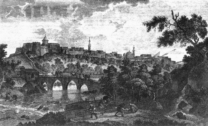
Plate I. View of Erevan in 1796 by G. Sergeevich. Courtesy of Aram Arkoun.
iii. THE MODERN CITY
Situated at one of the lowest points on the Armenian Plateau at an altitude of 983 m above sea level, Erevan lies at the easternmost edge of the Ararat Plain at the juncture of the Getar and the Hrazdan (Zanga) Rivers, 21 km north of the latter’s juncture with the Arax and 51.50 km north of Mt. Ararat. The city encompasses some 250 sq km with an elevation averaging just over 1,000 m.
Made the center of their rule in Eastern Armenia by the Persians in the sixteenth century, Erevan has remained the capital of Eastern Armenia ever since. It was the administrative center of the Armenian province (Armyanskaia Oblast’) following the Russian annexation in 1828 and served as the capital of the Erevan Governate (Erevanskaia Gubernia) created on 9 June 1849. After the Bolshevik revolution and the ensuing civil wars in Russia and the establishment in 1918 of the Armenian Republic, with Erevan as its capital, the city became the center of all Armenian hopes for the next two and a half years. The fall of the Armenian Republic and Sovietization made Erevan the center of the new Soviet Armenia, which became part of the Transcaucasian Federation until 1936. Erevan became a major technical, education, research, and industrial center of the Caucasus. It also became the center of Armenian national movements as well as cultural and political revival during the Gorbachev era. Since the fall of the Soviet Union and the establishment of the second Armenian Republic, Erevan has renewed its age-old ties with Persia. An Iranian embassy exists in the capital and an Armenian embassy has been opened in Tehran. Trade has been opened and a number of delegations of one kind or another have been exchanged between the two countries. There is a Center for Iranian Studies at the University of Erevan, as there are programs in Armenian studies at the Universities of Tehran and Isfahan.
Due to centuries of warfare, by 1804 Erevan’s population had been reduced to 6,000. It began to rise once again during the tenure of the last khan, and in 1827 it exceeded 20,000, with the Armenians forming barely twenty percent of the population. Following the Treaty of Torkamānčāy and the Armenian immigration from Persia and Turkey, the Armenian population rose to 40 percent of the total. The overall population, however, decreased to some 12,000, as the Persian forces and administration. emigrated. Although the capital, the city of Erevan in the tsarist period was thus a smaller place than nearby Alexandropol, having in 1890 about 15,000 inhabitants against twice as many for the latter. Despite new Armenian immigration from the Ottoman Empire, Erevan’s population increased only to 30,000 between 1831 and 1913, with Armenians finally achieving a majority. Erevan’s loss of trade and strategic position precluded it from participating in the economic rise taking place in some other Transcaucasian cities. By 1926, however, Erevan’s population had doubled to 65,000; by 1939 it reached 205,000. Between 1939 and 1959 the population of Erevan more than doubled again, reaching 518,000. In 1970 the city had a population of 775,000, and in 1990 it was 967,200 (Haykakan sovetakan hanragitaran III, p. 549). The present population, including the newly-arrived survivors of the 1988 earthquake and refugees from Azarbaijan, is estimated to be more than 1.2 million.
Under Russian rule, Erevan remained essentially an oriental town of one-story, flat-roofed, adobe houses, set in adobe compounds presenting only blank walls to the streets (Lynch, I, chap. 15). According to Harry Luke, the older quarters on the slopes of the hills, with attractive houses and gardens, contrasted sharply with the dreary basalt buildings constructed during the Russian period in the lower parts of the city (p. 199). The town itself was clouded with dust and plagued by flies, and in the heat of the summer the entire population not wealthy enough to retreat to the country villages around the town (Kʿanakʿer, Avan, etc.), still slept on the roofs at night. The city suffered terribly during the period of the First World War and was described by one traveler as “the saddest town I have ever seen” (Luke, p. 200).
Despite the restrictions imposed by the regime, Erevan, as the capital of a province, did have the right to an ecclesiastical seminary. Under this name the Armenian Church was able to maintain an important Armenian school in the town attached to the church of Saint Sargis and dispensing both elementary and secondary education. In Lynch’s time (ca. 1895), a girl’s school served two hundred pupils. Erevan also possessed a well-appointed, state-supported Russian secondary school of the German type known as a gymnase (Lynch, I, p. 218). According to Lynch, the population of the Erevan in the early 1890’s was half-Armenian, half-Tatar (i.e. Azeri, although Lynch thought that many among the Muslims were actually Persians), with about 300 Russians largely employed in the administration or serving as carriage drivers (Lynch, I, p. 209). The Russians had plowed through the tangle of medieval alleys and lanes to lay out a “modern” street of one-story shops leading to a square faced by the government building. Badly paved with rough cobblestones, this thoroughfare, now Abovyan Street, was equipped with a streetcar system by the First World War. To the south of the square there was laid out a small anglisky žardin such as one might find in any Russian town. The former palace of the sirdar was in ruins, only his private pavilion remaining, and the fortress, wrecked in the war of 1827, was not maintained either. A rather large Russian Orthodox church crowned with domes was erected but demolished in the Soviet period. With the exception of a cognac distillery, a brick yard and a few small manufactories, Erevan had no industry until the Soviet period when a number of state enterprises (chemicals, textiles, etc.) were initiated that eventually turned the city into an industrial center of some importance (Mesrobian, pp. 7-15; Haykakan sovetakan hanragitaran III, pp. 557-58)
Under Soviet rule (1920-91), the first attempt was made to develop the Erevan into a “modern” city. Working from plans developed by the architect Alexander Tamanyan in the 1920s, a number of broad boulevards were constructed and spacious plazas laid out (see Haykakan sovetakan hanragitaran, XII, p. 393). Following traditional architectural styles that Tamanyan and his school adapted to modern purposes, and using the traditional local building materials, tufa and basalt, a number of handsome public buildings and apartment blocks were constructed, especially after the Second World War (Mesrobian, p. 39). The original plan for the city, drafted by Tamanyan in 1924, envisaged an ultimate population of 150,000; but as it increased to nearly one million, plans for the future development of the city had to be revised a number of times (Mesrobian, p. 39; Haykakan sovetkan hanragitarian III, p. 549). In the course of these constructions, the face of Erevan was totally changed; almost all of its earlier buildings were demolished. The city was electrified in the 1930s, sewers were built, running water was introduced, streets were paved, the Getar Steam was embanked with stone, and the ruined fortress, dilapidated Sirdar’s palace, and picturesque open bazaar were cleared away. Erevan, half surrounded by an arch of barren hills, was long subject to frequent dust storms but these were brought under control by the reforestation program that planted the surrounding hills with trees in the 1950s. As the city grew beyond its original limits, it engulfed the nearby villages, which became the first suburbs of the city. As it continued to expand, however, a number of planned suburbs were constructed as a means of channeling growth. The most important of these are, clockwise from west to east: Noragiugh, Nor Kilikia, Nor Malatia, Nor Sebastia, Shahumyan, Spendiaryan, Anastasavan, Davitʿashēn, Nor Arabkir, Nor Zeytun, Nor Norkʿ, Nor Marash, Saritagh, Nor Butania, Vardashēn, Nor Aresh, noragavit, Nerkʿin Shēngavit, and Verin Charbakh. A recently developed suburb was named Bangla Desh. The ancient villages of Kʿanakʿer and Avan lying to the northwest of the city may be considered outlying suburbs today (map in Haykakan sovetakan hanragitaran III, p. 553.)
Erevan rapidly became the focal point of everything in Armenia. Almost a third of the Armenian population lives there, and it is the center of political, industrial, educational, artistic, literary, theatrical, musical, scientific, intellectual, and cultural life, as well as of publication. The major institutions of higher education include the Erevan State University, founded in 1921, and now possessing more than thirty buildings, with departments of medicine, law, engineering, sociology, pedgogy, etc.; the Erevan Polytechnical Institute (formerly named for Karl Marx), the Medical College, the Abovyan Pedagogical Institute, the Komitas Conservatory of Music, the Institute for Physical Culture, and the new American University of Armenia (AUA) founded in 1991 with funds provided by the American General Benevolent Union of America and supported by the expertise of the University of California at Los Angeles (UCLA) with which the institution is affiliated. The Miasnikyan State Library founded in 1921 (now the National Library) is the largest in the Republic with over four million volumes (Mesrobian, pp. 80-82). In a category by itself is the Mesrop Mashtotsʿ Institute of Manuscripts (the Matenadaran). Housing the largest collection of Armenian manuscripts in the world, some eleven thousand volumes, it contains almost as many manuscripts in other languages (Persian, Turkish, Arabic, etc.). The Institute consists of three sections devoted respectively to collection, preservation and publication. The Matenadaran has its own library as well as a small but rich museum of illuminated texts, and publishes an occasional journal, the Banber Matenadarani (Bulletin of the Matenadaran). The most important of the twenty or more museums in Erevan is the State Museum of History located in the old tsarist government center, which received a handsome new facade in the 1950s and was later enlarged by the construction of a number of additional stories. Opened in 1921, it contains sections devoted to archaeology, ethnography, numismatics, historical architecture, and modern Armenia (Mesrobian, pp. 46-53) The Museum of Erevan, housed in the old Gök Jāmeʿ, contains one room devoted to the excavations of the Urartian fortress at Arinberd (located within the limits of the present city), a second to the finds at Erebuni, and a third to the period of Persian rule. Subsequent exhibition halls detail the tsarist period, the revolutionary era, the sovietization of the country, and developments under Soviet rule (Mesrobian, pp. 62-65). The chief theater of Erevan is the Spendiaryan Opera and Ballet Theater, designed by Tamanyan and opened in 1931. A boldly conceived structure of gray granite with twin auditoriums, it is one of the oldest modern structures in the city and was greatly enhanced by the later construction in front of its eastern facade of a small but beautiful park set with a lovely lake. The Opera Square became famous in the years 1988-90 when it was the center of mass demonstrations demanding the return to Armenia of Qarābāḡ.
Erevan has been adorned with a remarkable number of monuments, large and small, most of them beautifully designed. These include the monument to Stepʿan Shahumyan, founder of the Armenian Communist party, and the nearly twenty statues commemorating among others the writers Khachʿatur Abovyan, Michael Nalbandyan, Avetis Isshakyan, and Ełishē Charentsʿ; the dramatist Shirvanzade (Šarvānzāda); the composer Spendiaryan; the architect Tamanyan; the revolutionaries Lukasyan and Azizbekov; the composer-troubadour Sayat Nova; the folk hero David of Sasun; and the monument to Armenian-Italian friendship. Statues of Mesrop Mashtotsʿ, Ananias of Shirak, and Gregory of Narek stand on the terrace of the Matenadaran. Especially interesting is the Pantheon, a grove in one of the old cemeteries of the city where the great Armenian authors, poets, and actors are buried.
At the outset of the Soviet period, Erevan possessed ten nondescript churches built between the 17th and 19th centuries. In the 1930s, most of these were demolished in the course of widening streets, etc. One was replaced by a cinema; another by a school. The belfry of the old 12th century cathedral, now in the courtyard of the Historical Institute, narrowly escaped demolition. In the 1970s, Saint Sargis, built in 1853 and then hidden behind a large Soviet era apartment building, was handsomely rebuilt, perhaps the only church erected anywhere in the Soviet Union. All of the mosques of the city were closed during the Soviet period, and with the departure of most of the Muslim population since 1991 it seems doubtful that any new ones will be opened. There is, however, a joint Armeno-Iranian archaeological project under way to restore the Gök Mosque. In April 1997 the cornerstone was laid for a new cathedral dedicated to St. Gregory the Illuminator, to be completed by 2001 in time for the commemoration of the 1700th anniversary of the traditional date of the conversion of Armenia to Christianity.
(for cited works not given in detail, see “Short References”):
Anonymous, “Notice de la ville d’Érivan, capitale de l’Arménie russe,” Journal Asiatique, ser. 2, 12, 1833, pp. 256-62.
M. Atkin, Russia and Iran, 1780-1828, Minneapolis, Mn., 1980.
J. Baddeley, The Russian Conquest of the Caucasus, London, 1908.
M. Elliot, Beginning Again at Ararat, New York, 1924.
A. von Haxthausen, Transcaucasia: Sketches of the Nations and Races between the Black Sea and the Caspian, London, 1854.
T. X. Hakobyan, Erevani patmutʿyun (History of Erevan), 4 vols., Erevan, 1959-71.
Idem, Haykakan patmakan aßxarhagrutʿiwn (Armenian Historical Geography), 2nd. ed., Erevan, 1968.
Haykakan sovetakan hanragitaran (Armenian Soviet Encyclopedia), 10 vols., Erevan, 1974-83.
Haykakan SSR Atlas, Erevan, 1961. H. C. Luke, Anatolica, London, 1924.
H. F. B. Lynch, Armenia: Travels and Studies, I, London, 1901.
M. Matossian, The Impact of Soviet Rule on Armenia 1962.
P. Mesrobian, ed. and tr., Getting around Yerevan, Erevan, 1960.
V. Potto, Kavkazskaia voina (The Caucasian War), 4 vols., St. Petersburg and Tiflis, 1885-91.
M. Shaginyan, A Journey Through Soviet Armenia, Moscow, 1954 (in English).
I. Shopen, Istoricheskii pamiatniki sostoianiia Armianskoi oblasti (Historical Monuments of the Conditions of the Armenian Province), St. Petersburg, 1852.
Tavernier (London). C. Toumanoff, Manuel de généalogie et de chronologie de la Caucasie chrétienne, Rome, 1976.
A. Yeghenian, The Red Flag at Ararat, New York, 1932.