

CAUCASUS and Iran.
Physical Geography, Population, and Economy
I. Physical geography.
Relief and structure. The Caucasus range (the Great Caucasus in Russian terminology) is about 1,100 km long, extending from the vicinity of the Taman (or Anapa) peninsula to the Apsheron peninsula, on an axis oriented west-northwest to east-southeast. Its total area is about 145,000 km2, and it is 180 km wide in the region of Mount Elbrus. A dozen or so peaks surpass an elevation of 5,000 m. On its north side the range, which is generally interpreted as an enormous complex of anticlines (Gvozdetskiĭ and Mil’kov, pp. 356, 380; Gerasimov, pp. 228-39), rises gradually in a series of parallel chains above the Kuban and Terek plains, which are separated by the Stavropol sill; on the south side it towers over the basins of the Transcaucasia, two opposing triangles that open toward the Black Sea (the Colchian lowlands) and the Caspian Sea (the Kura and Araxes basins) respectively with their apexes meeting in the Surami sill. In addition to this dissymmetry between the northern and southern faces, the range is divided by Mounts Elbrus and Kazbek into three distinct regions on its southern side: the western, central, and eastern Caucasus.
The northern side of the range consists of a series of monoclinal folds, in the form of cuestas, with escarpments facing toward the main chain and the more gradual back slopes fanning out into plateaus of varying sizes, all inclining toward the north at angles of from 5 to 15 degrees. The northernmost ridge, the Neocene cuesta (Lesistyĭ, or “forested,” ridge), rises from the alluvial zones of the piedmont. The next (Pastbishchnyĭ, or “pastoral,” ridge), consisting of Upper Cretaceous limestones, rises to 1,200-1,500 m (the Burgustan and Dzhinal spurs). The highest, the Skalistyĭ (“rocky”) ridge, so-called because of its imposing wall of Lower Cretaceous and Upper Jurassic limestones, reaches an elevation of 3,646 m. It has undergone glaciation in the Quaternary, and its plateaus contain numerous karstic forms. A series of longitudinal depressions has developed along the bases of these cuestas, but only the Jurassic northern depression south of the Skalistyĭ ridge is of significant size. Even there, however, the trough is not continuous, and the component basins are clearly distinct from one another. Each monoclinal fold is steeply cut by the deep gorges of cataclinal rivers (e.g., the Kuban, Baksan, and Terek). In the eastern Caucasus, particularly in Dagestan, the flat lands are much more extensive and part of a more complex structure, in which synclinal plateaus are developing on top of the Jurassic and Cretaceous limestones that dominate the Koysu gorges. Farther upstream the Middle and Upper Jurassic schists have been intensely eroded. The Samur valley and the upper basin of the Koysu constitute a single longitudinal depression.
Figure 5. Relief map of the Caucasus (after Kavkaz 1966)
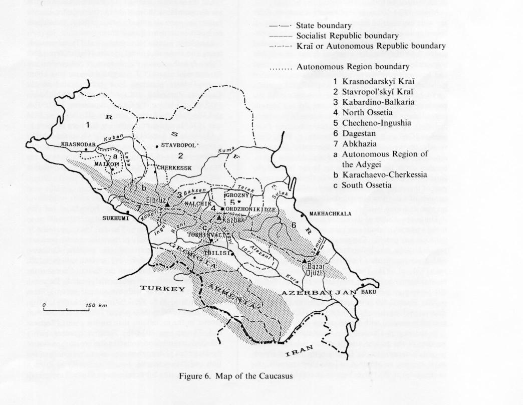
Figure 6. Map of the Caucasus
The backbone of the Caucasian orographic system (Gvozdetskiĭ and Mil’kov, p. 380) is composed of principal and lateral chains, which mark the watershed. The principal chain is in the central part of the Caucasian anticlinorium. It consists of horsts of primary crystalline rock (schists and gneiss with granitic intrusions), which rise above 4,000 m. The highest peaks are in the lateral chain; they include the volcanic cones of Mount Elbrus (5,642 m) and Mount Kazbek (5,033 m), which rest on foundations of crystalline and Jurassic rock respectively. It is in this axial zone of the central Caucasus that the most beautiful high-mountain topography is found and that glaciation is most extensive. In the western Caucasus the elevations gradually diminish, and the crystalline foundation disappears under Jurassic, Cretaceous, and Paleocene deposits. Several peaks in the eastern Caucasus rise above 4,000 m (Mount Tebulos Mta 4,493 m, Bazar Dyuzi, 4,466 m, Shakh Dag 4,260 m); although glaciation is minimal in that region, erosion has been particularly severe because of the presence of Jurassic schists.
The steep, narrow southern face of the range, which measures barely 20 km from the crest of the principal chain to the Alazani valley, consists of a series of individual ridges and troughs reflecting repeated longitudinal fractures and displacements toward the south. Along the western section of the mountains, in Abkhazia, an important karstic network has developed among the rectangular folds of the Upper Jurassic and Cretaceous limestones. In the extreme west the range plunges directly into the Black Sea. Farther east the southern slope of the Surami sill is prolonged by the ancient Dzirulo massif, which links it to the mountain system of the Lesser Caucasus, separating the Colchian lowlands from the Kura basin.
Both these lowland areas are deep depressions partly filled by enormous deposits of Tertiary sediment (several kilometers thick) and Pliocene and Quaternary alluvia (up to 700 m thick in the Colchian lowlands; Gvozdetskiĭ and Mil’kov, p. 394). Equally large deposits occur in the shallower Kuban and Terek basins flanking the Stavropol sill in Northern Caucasia, where, in the region of Pyatigorsk, the foundation emerges in a series of laccoliths (e.g., Mount Beshtau).
These broad structural assemblages were established in the Miocene and Pliocene (Gerasimov, pp. 234-39), with the formation of the monumental Caucasian anticlinal folds and the basins of the Black and Caspian seas and the concomitant sinking of the Scythian plate and the Transcaucasian basins. These movements have continued in the Quaternary, accompanied by powerful volcanic activity; according to Soviet authors, the present formations, especially the transversal gorges, are mainly the results of tectonic shifts in the Holocene. Recent measurements (Lilienberg) have permitted estimates of the lift during the 20th century; 0-2 mm a year in the northwestern Caucasus, 10-13mm a year in the central and eastern Caucasus, 5-8 mm a year in the extreme southeast. Conversely, the Terek basin is sinking 2-3.5 mm a year. These shifts are accompanied by major seismic activity. Several earthquakes registering higher than 8 on the Richter scale have struck Dagestan in recent decades (1948, 1966, 1970, 1975). Shemakha in Azerbaijan has been destroyed several times. The upper Terek valley and the Kuban plains have also experienced earthquakes of great magnitude in the course of the 20th century.
Climate. The Caucasus is situated on the boundary between the temperate and subtropical climatic zones, and the orientation and height of the range reinforce the contrasts between the two. At sea level the average annual temperatures are approximately 10° C in Northern Caucasia and 16° C in Transcaucasia. The differences are more pronounced in winter, when Northern Caucasia is subject to thermal anticyclones from Russia, bringing average January temperatures of -5° C on the Kuban plains and an absolute minimum of -35° C, whereas in the more sheltered Transcaucasia the January average is 3° C in the west and 6° C in the east, with an absolute minimum close to -20° C on the plains. In summer the temperatures are very similar in all parts of the Caucasus, though slightly higher in the east at noon, owing to more continental location (23-24° C in the west, 25-29° C in the east). Winters are not much more severe in the mountains than on the piedmont because the cold air remains stationary at lower elevations; in the Klukhor pass in the central Caucasus (elevation 2,037 m) average January temperatures range from -8° to 4° C (absolute minimum -31° C; Radvanyi, 1977, pp. 22-28). The summers are hot, averaging 16.5° C at Klukhor in August, with an absolute maximum of 32° C. In July the zero-degree isotherm reaches elevations of 3,700-4,000 m.
In addition, the Caucasus is also the region of translation between humid Atlantic and Mediterranean winds, on one hand, and dry continental air currents, on the other. On the plains the transition occurs on the Stavropol and Surami sills and in the mountains between Mounts Elbrus and Kazbek. West of this line the Kuban depression in the north receives 400-800 mm of precipitation, the mountains more than 1,500mm (up to 4,000 mm on certain peaks), the Colchian lowlands in the south 1,500-2,000mm. To the east of the line it is dry: Less than 1,000 mm of precipitation falls in the mountains, the basins in the interior lowlands of Dagestan are semiarid (250 mm at Botlikh, elev. 1,300 m), and less than 200 mm falls on the Apsheron peninsula. Precipitation comes from the west, in storm systems that are replenished over the waters of the Black Sea, which explains the contrasts between the eastern and western ends of the Caucasus range and also between the well-watered Colchian face and the dryer northern slopes. In the western Caucasus maximum rainfall occurs in winter, in the central and eastern Caucasus in summer. Furthermore, the depth and duration of the snow cover also vary between the western and eastern sections of the range. At an elevation of 1,900 m the western Caucasus receives an average of 1,200 mm of solid precipitation between November and March, compared to only 395 mm at the same elevation in the eastern Caucasus (Kotlyakov and Krenke, p. 248). These figures can vary considerably, however; for example, 10 m of snow fell on the Krestov pass in January 1987. The permanent snow line rises in parallel fashion: from 2,900-3,100 m in the western Caucasus to 3,200-3,500 m in the central Caucasus and 3,600-3,900 m in the eastern Caucasus.
There are 2,047 glaciers in the Caucasus range, covering a total of 1,424 km2. More than half (1,110) are situated in the central Caucasus; they cover an area of 1,033 km2, that is, 72.5 percent of the total glaciated surface in the entire range. There are 565 glaciers in the western Caucasus and 372 in the eastern Caucasus, with surface areas of 278 km2 and 113 km2 respectively. The total volume of ice in the 1980s was estimated at 118.6 km2 (Kotlyakov and Krenke, pp. 246-47). Between 1880 and 1960 it had shrunk about 25 percent, but it appears that now the glaciers are receding more slowly and are even becoming stabilized in certain basins (Kotlyakov and Krenke, p. 261).
The large rivers—the Kuban, Baksan, Terek, Sulak, and Samur on the northern slope and the Inguri, Rioni, Aragvi, and Iori on the southern slope—are fed by the glaciers, and the period of high water thus begins in March, when the snow melts, and lasts into July and August. The greatest volume occurs in summer, when the silt content of the streams is considerable. It is even greater in the east, where there is less vegetation cover: 200 g/m3 in the Kuban, 1,925 g/m3 in the Terek at Ordzhonikidze, 6,570 g/m3 in the Samur at Usukhchaĭ (Radvanyi, 1977, pp. 31-32). These figures attest the strength of the erosion process. In addition, there are frequent sels (mudflows or freshets laden with mud) during prolonged periods of rain and melting snow.
Vegetation and soils. The geographical position of the Caucasus provides favorable conditions for a great range of flora. More than 6,000 species have been enumerated in the region (Zimina and Saint Giron, p. 331). The distribution of flora, which is determined by the terrain and climate, permits identification of several distinct regions, each with its own sequence of zones of elevation.
In the western and central Caucasus the lower forest zone consists of deciduous trees on gray or brown forest soils; oaks (Quercus petraea and Quercus robur on the northern slopes, Quercus iberica in western Georgia and on the Pontic slopes) predominate, along with hornbeams (Carpinus betulus). The zone of transition to piedmont vegetation distinguishes the Kuban regions on the north from the Colchian slopes in the south. In the former these oak and birch forests yield to a wooded steppe, which gradually gives way to the steppe proper, or chernozem. On the other hand, the hornbeams, chestnuts, and oaks of the vestigial Colchian forest, including Castanea sativa, Carpinus caucasica, Celtis caucasica, which shelter a thick undergrowth of perennials (Rhododendron ponticum, Hedera colchica) mingled with several species of liana (Smilax excelsa), predominate up to elevations of 500-600 m, on brownish-yellow or carboniferous soils.
Above 900-1,100m in the western Caucasus there are wide expanses of beech trees (Fagus orientalis) on brown soils, the most common formation in the mountains. On the moist southern slopes they are succeeded above 1,500-1,600 m by a mixed forest of conifers (spruces and pines, Picea orientalis, Abies nordmanniana) and beeches on brown podzolic soils, often succeeded in the upper mountain zone by a forest of dark conifers up to 2,000-2,200 m. In the more arid valleys on the northern slopes beeches and spruces do not appear; instead above the oak trees there is a zone of pine trees, including Pinus silvestris, Pinus sosnowskvi, and Pinus hamata (Grebenshchikov and Ozenda, p. 345). Conversely, on the southern face of the central Caucasus, especially on the north side of the Alazani basin, beeches cover the entire slope up to the limit of the forest zone (Radvanyi, 1977, p. 47), though the upper part of this zone, between 1,800 and 2,500 m, generally consists of a mixture of small deciduous trees (birches, maples, and even beeches).
The lower reaches of the alpine zone (2,000-2,500 m) in the western Caucasus are characterized by tall grasses (Altherbosa), notably Campanula lactiflora and Campanula latifolia, which stand taller than a man, mingled with flowering shrubs (Rhododendron caucasicum; Livret, 1974, pl. 13). These high meadows grow on brownish-gray mountain chernozem (Livret, 1974, p. 40) or spongy peat soils (Gvozdetskiĭ and Mil’kov, p. 388). From 2,500 m up to the snow line (3,200 m in the western Caucasus, 3,600 in the central Caucasus) the ground is covered with alpine grasses and wild grains.
In the eastern Caucasus the vegetation is different because of the greater aridity, which is hospitable to mountain xerophytes. In Dagestan the semiarid piedmont steppes, on chestnut or light-chestnut soils, rise to elevations of 500-700 m. Vegetation consists especially of artemisias (Artemisia lercheana, Artemisia taurica). The forests, which have been largely destroyed by lumbering, extend up the outer slopes, where a few oak trees (Quercus petraea) and occasional stands of beeches (Fagus orientalis) survive. On the northern inner slopes of the range there are pines (Pinus sosnowskyi) and birches (Betula raddeana; Radvanyi, 1977, p. 286; Livret, 1982). In the zone between 500-700 m and 2,000-2,500 m the most characteristic formations are the shibliak and mountain steppes. The shibliak is a loose formation of Mediterranean semixerophilous caducifoliate shrubs (on limestone surfaces Rhamnus pallasii, Ephedra procera, and the like, otherwise Paliuris spina-Christi, Lonicera iberica, Berberis vulgaris, and so on). They grow on chestnut soils, usually the products of forest decay. The plateaus are covered by dry mountain steppes on mountain chernozem, which occurs in several variants, with xerophilous graminaceae (Festuca sulcata) and andropogons (Gvozdetskiĭ and Mil’kov, p. 390). The alpine zone, from 2,500 to 3,600 m and higher, is equally impoverished in comparison with the western and central Caucasus; it consists entirely of xerophytic meadows (Festuca varia).
On the interior southern slopes the characteristics are comparable to those of the northern slopes, but the forests are more abundant and the shibliak and steppes do not constitute a separate zone.
In order to protect the vegetation and fauna, notably bears and endemic animal species (Capra Severtzovi, Capra cylindrocornus, Prometheomys Schaposhnikovi, Lyrusus mlokosiewiezi, Tatraogallus Caucasicus), about twenty nature preserves have been created in the Caucasus. The oldest, at Lagodekhi, was established in 1912, the two largest (the Caucasus preserve, 266,000 ha, and the Teberda-Arkhyz preserve, 83,400 ha) in 1924 and 1936. In addition, lumbering has been restricted.
Owing to its natural features, the Caucasus exhibits a degree of biogeographical continuity with the northwestern regions of Persia, but its mountainous terrain has served as an important obstacle to population movements between the two areas.
II. Population
The population within the boundaries of the Caucasus range has been estimated at 1.25 million in an area of 103,000 km2 (Thorez, 1983, pp. 661-62), that is, an average density of more than twelve per km2. In fact, a large part of the western Caucasus is almost uninhabited, as are several valleys in the central Caucasus, whereas in the eastern Caucasus the population density is often extremely high: In Dagestan in 1970 it rose along with the altitude up to 1,500 m (below 500 m: 26.8, 500-1,000m: 28.3, 1,000-1,500 m: 42.1, 1,500-2,000 m: 36.0, above 2,000 m: 3.7) and was greater in the mountains than on the plains (Reparaz and Thorez, pp. 103-04). These differences partly reflected natural conditions like the broad expanses of the Dagestan plateaus but even more the history of the 19th and 20th centuries.
The population has experienced and is still experiencing the effects of the Russian conquest of the northern piedmont. For example, after their defeat in 1864 the Circassians were driven from the mountains; this displaced population has been estimated at about half a million (Pokshishevskiĭ, pp. 514-28). The western Caucasus remains almost entirely uninhabited because no group has come to replace the Circassians. In the central and eastern Caucasus colonization of the piedmont by the Cossacks drove the Caucasians into the mountains. Then, when the Cossacks went to war in 1914, their departure was followed by massive migrations of mountain dwellers into the abandoned stanitsas(Cossack villages; Khristianovich, pp. 61-67).
After the establishment of Soviet power there was an administrative reorganization, based primarily on national and linguistic criteria (Radvanyi, 1985, p. 26). The Caucasus today is thus partitioned among three federated republics (Russian Soviet Federated Socialist Republic, Azerbaijan Soviet Socialist Republic, Georgian Soviet Socialist Republic), five autonomous republics (Kabardino-Balkarian Autonomous Soviet Socialist Republic, North Ossetian Autonomous Soviet Socialist Republic, Checheno-Ingush Autonomous Soviet Socialist Republic, Dagestan Autonomous Soviet Socialist Republic, Abkhazian Autonomous Soviet Socialist Republic), and three autonomous oblasts(Adygei Autonomous Oblast, Karachayevo-Cherkess Autonomous Oblast, and South Ossetian Autonomous Oblast). All these entities also include territory outside the mountains. Their capitals are located on the piedmont and, except for Tbilisi in Georgia and Baku in Azerbaijan, have long been inhabited mainly by Russians, a circumstance that for a considerable time slowed the exodus of the mountain people, who were hesitant to leave their auls (mountain villages) and settle in a milieu unfamiliar to them (Thorez, 1983, pp. 673-74). Subsequently, however, new villages were founded on the plain and large-scale migrations organized. In the 1920s the populations of twenty-two Karachai villages were transplanted to the plain, 30,000 mountain dwellers from North Ossetia came to settle in fifteen new villages, and 12,000 Chechen families were also involved in these mass migrations. The situation was different in Georgia, where Georgians are the main component of the population, both in the urban centers of the piedmont and in the mountains. The latter was rapidly depopulated to the benefit of the piedmont, where living conditions are much less difficult (Dzhaoshvili, 1968, p. 295). Between 1942 and 1945 many inhabitants of the Caucasus were evacuated or deported; Balkars, Chechens, Ingush, and Karachai even lost their national rights for a time (Wixman, pp. 126-36). Although a number of them returned to their lands after 1956, the population density has never reached its prewar level.
Today the population of the mountains remains almost exclusively rural. The upper limit of permanent habitation is at an elevation of 2,400 m, in the aul of Kurush in Dagestan. Forms of settlement vary with the region. In the damp climate of the western Caucasus no trace of the old wooden villages of the Circassians survives. The fields of the very large agricultural villages on the piedmont, each with several thousand residents, are laid out along the streams in almost continuous strips. At higher elevations they yield to occasional pastoral and forest villages; the higher the elevation the more widely spaced these villages are and the smaller the number of inhabitants. There are no permanent settlements above 1,300 m in this part of the Caucasus. The houses are built of stone and set in gardens, so that they are separated from one another. The region of aulsbegins east of the Baksan and Kodori rivers. The aul is a village of several dozen to several hundred inhabitants, in which the houses abut each other and the lanes are defined by dry stone or mud-brick walls. Depending on the terrain, the house may adjoin the stable or sheepfold or be placed above it. The traditional rooftop terraces are gradually being replaced by tiled roofs, and new houses are proliferating on the outskirts. This type of village, which is particularly characteristic of Dagestan, also occurs in the central Caucasus, where the houses are larger and often roofed with flat stones. The celebrated towers of Svanetia, used as granaries and places of refuge, are attached to houses consisting of single rooms shared by humans and animals; they are now classified as historic monuments.
New constructions are more homogeneous throughout the Caucasus, despite the variety of materials used in different regions (e.g., dry stone or mud brick). They are cubical in farm, with a ground floor of tamped earth or concrete, which serves for threshing and stabling. The second story, usually reached by an outside staircase, is reserved for living quarters. It is divided into several rooms and surrounded by a balcony or porch. The roof, often covered with metal sheets, but sometimes with flat tiles, is two-paneled in the north central Caucasus and four-paneled on the southern slopes and in the entire eastern Caucasus.
The predominantly rural character of the Caucasian population partly accounts for the high natural growth rate in the eastern Caucasus, though it is declining. Despite the exodus to the piedmont, which was accelerated in the 1960s, the mountain population continued to grow until the beginning of the 1980s, at least in Dagestan and Azerbaijan. Fertility is still high in those regions, in contrast to the western and central Caucasus, where the population has aged and the birth rate declined as a result of the exodus. In those parts of the mountains the most isolated villages are seasonally depopulated, and many are eventually totally abandoned. Beside the traditional migrations associated with transhumance, new forms of temporary migration have appeared; many of those who have left the villages to work in the cities return in the summertime to help with the haying, and young men who have been hired for Siberian work crews come home after several months or even two or three years. In some instances the abandonment of villages is accelerated by natural catastrophes. The exceptionally heavy snowfalls and floods in the Georgian Caucasus during the winter of 1986-87 caused the departure of 2,800 families—about a third of the inhabitants—from Svanetia (Dzhaoshvili, 1988, p. 64).
There are also a few larger towns scattered in the mountains. Most often they are characterized by single economic activities (e.g., extractive industries at Tyrny Auz, Sadon, and Chiatura; tourism at Teberda; hot springs at Tskhaltubo). Small urban centers located in proximity to the mountains, like Karachayevsk, Kuba, Shemakha, Ambrolauri, Tsageri, and Oni, have more diversified functions, notably commercial, administrative, and service.
III. Economy
For reasons of geography (e.g. peripheral location within the U.S.S.R. and constraints of the physical environment), history (e.g., relatively late conquest by the Russians), and ethnic composition (e.g., the presence of many national minorities), the Caucasus, especially its eastern regions, remained far a long time and, despite recent efforts, still remains poorly integrated into the Soviet economy and has been only slightly affected by the changes that have transformed the latter (Durbiano et al., p. 118). Income in the mountains is lower than on the plains; in Georgia individual productivity in the mountains is two or three times lower than the average for the republic as a whole (Kobakhidzhe, p. 58). Economic and social structures have been modified on the same pattern as in the rest of the country, though sometimes only rather late; for example, collectivization of the land did not begin in Svanetia until 1940. Nevertheless, the systems of production have changed little in the mountains, and the Caucasus is still primarily characterized by an agricultural and pastoral mountain economy. More than half the working population is employed in the agricultural sector (Mekhraliev and Salmanov, p. 107).
Production is organized within a tripartite framework, consisting of kolkhozes (collective farms), sovkhozes (state farms), and the auxiliary domestic sector. Each collective farm encompasses several villages. In the central and eastern Caucasus, where transhumance is common, there are cultivated lands near the auls, high summer pastures on the axial chain of the mountain range, and winter pastures and irrigated cultivation on the piedmont (in particular, the Kizlyar and Shirvan steppes). The private sector has for a long lime been limited to parcels of land of 0.25-0.50 ha for personal use and flocks of twenty to fifty sheep. Since 1982 such private endeavor has been encouraged, however, and since 1985 new forms of relationship between the collective and private sectors have been developed, with the introduction of family contracts and the allotment of land, livestock, and means of production to the contractors.
The specific nature of agricultural activities is determined by the zone of elevation, and there are also differences between the western Caucasus, where cattle raising predominates, and the rest of the range, where sheep and goats are the main livestock. Cattle breeding plays an essential economic role, accounting for 40-90% of the income of the mountain people. Cattle raising in the more humid west requires seasonal shifts between villages and summer farms. To improve the milk yield of the small native breeds, which produce only 1,200-2,000 liters a year per cow, crossbreeding has been introduced, and artificial insemination is becoming common. On the other hand, milking barns have been constructed near villages to limit the necessity for moving lactating cows. In the central and eastern Caucasus flocks of several thousand head of sheep and goats are herded in a pattern of inverse transhumance over hundreds of kilometers, sometimes through several republics. The animals are sheared twice a year, when they return to the villages before and after the alpine pasturing. The simple rustic (tushinskiĭ “grazing”) Caucasian species yield modest amounts of wool and meat, but they are very sturdy and inexpensive to raise. As for sheep’s milk, commercial production has only begun.
In the high mountains a much smaller proportion of the land is cultivated; thus, in the mountainous region of Dagestan, crops occupy only 5.4 percent of land for agriculture, hay meadows 15.3 percent, and pastures for flocks 77.9 percent (Durbiano et al., p. 115). In the high valleys crops, mainly a few potatoes, are grown only on the private plots. At medium elevations they are more important, and the total area devoted to them is increasing as specialized crops are introduced or expanded, at least in the eastern Caucasus (Thorez, 1987, pp. 356-60). In addition to cereals (rye and corn), which are grown on the plateaus or, in Dagestan, on slopes divided into strips and terraces, such forage crops as beets have been developed; in the valleys of the eastern Caucasus legumes, fruit trees (e.g., apricots and pears), and grapes are grown on irrigated plots. Private farmers are beginning to install small fences, and slowly mountain agriculture is being transformed.
The industrial sector is dependent on local resources and agricultural products, a sign of underindustrialization. There is a rich handicraft tradition in the eastern Caucasus (See carpets xv. caucasian carpets). The goldsmiths and silversmiths of Kubachi and the weavers of Khuchni and Akhty have been celebrated for centuries, and their work is well known outside the Caucasus. In the Soviet period masters and journeymen have formed craft cooperatives, and this sector, which has been able to maintain a high level of production owing to the Soviet market, has remained vital to the present day. Few industries have been established in the mountains; the primary exceptions are mining (for wolfram and molybdenum at Tyrny Auz, manganese at Chiatura, and polymetallic minerals at Ardon) and quarrying. In the populated eastern region, where the work force is underemployed, small factories (e.g., for preserves and clothing) are beginning to be established.
Industrialization is hampered, however, by inadequate infrastructure, though all the permanently inhabited villages have now been electrified. At first small hydroelectric plants or groups of generators were used, but gradually the distribution grid has been extended. The piedmonts are supplied by large dams and powerful hydroelectric plants, for example, the plant at Chirkeĭ (800 mw) on the Sulak river, which powers several large factories in the valley (Durbiano and Nicod, p. 128), and those at Zhinvali on the Aragvi river and at Dzhvari (1,640 mw) on the Inguri river (Gruzinskaya, p. 122). In the high mountains, on the other hand, where power plants must occupy arable land, the necessary equipment was installed only rather late, for technical reasons arising particularly from the frequency of earthquakes. There are no good roads in the Caucasus. The main axial roads bypass it, and it can be crossed only by the Georgian military road through the Krestov pass or by the Mamison pass. The transverse valleys in the north (e.g., those of the Kuban and Baksan rivers) are accessible, but many villages can be reached only by stony roads. Construction of paved roads was speeded up after 1975, and a Transcaucasian railroad is already under construction between Tbilisi and Ordzhonikidze via the Aragvi and Terek valleys.
The difficulties of travel have also slowed the development of tourism, for which the Caucasus is otherwise well suited. Certain regions (like Svanetia and the interior of Dagestan) are blessed with architectural riches and many picturesque villages, virtual open-air museums (Dzhaoshvili, p. 62). Although springs are abundant, they are still only partially exploited as thermal spas. The largest resorts (e.g., Kislovodsk) are outside the mountains or on their periphery (Radvanyi and Thorez, pp. 187-91). Excursions into the mountains are organized from these and other large resorts on the Black Sea coast (Sochi, Gagra), but available lodgings are insufficient to accommodate many such groups. Since the 1970s winter-sports resorts have been established at Teberda-Dombay, Tseĭ, and Gudauri. Because of growing urbanization on the piedmonts an increasing number of people have second homes in the mountains, often original family homes that have been preserved after migration to the lowlands.
In the depopulated areas of the Caucasus the primary problem today is how to support the remaining population and increase tourist activities. In the eastern Caucasus ways must he found to diversify the economy and introduce new activities that will mobilize an underemployed population.
Bibliography:
C. Durbiano and J. Nicod, “Aménagements hydrauliques dans le Caucase oriental et en Crimée,” Méditerranée 2-3, 1987, pp. 125-32.
C. Durbiano, J. Radvanyi, and O. Kibalchich, “Les transformations contemporaines de l’économie des montagnes de Crimée et du Caucase oriental, comparison avec les Alpes du sud,” Méditerranée 2-3, 1987, pp. 111-23.
V. S. Dzhaoshvili, Naselenie Gruzii, Tbilisi, 1968. Idem, “Puti osvoeniya resursov gornykh territoriĭ SSSR,” Izvestiya AN SSSR, Geographic series 2, 1988, pp. 56-65.
I. P. Gerasimov, “Structure géologique et relief du Caucase,” Revue de géographie alpine 69/2, 1981, pp. 225-39.
O. S. Grebenshchikov and P. Ozenda, “Principaux traits de ressemblance et de différence de la couverture végétale,” Revue de géographie alpine 69/2, 1981, pp. 333-51.
O. S. Grebenshchikov et al., “Les écosystèmes naturels et leur étagement dans le Caucase,” Revue de géographie alpine 62/2, 1974, pp. 169-90.
A. A. Grossgheim, Rastitel’nyĭ pokrov Kavkaza, Moscow, 1948. Gruzinskaya sovetskaya entsiklopediya, Tbilisi, 1981.
N. A. Gvozdetskiĭ and F. N. Mil’kov, Fizicheskaya geografriya SSSR, Moscow, 1976.
Kavkaz, Moscow, 1966.
V. P. Khristianovich, Gornaya Ingushiya, Rostov, 1928.
E. D. Kobakhidzhe, Sotsial’no-ekonomicheskie i ekonomicheskie problemy gornykh raĭonov Kavkaza, Tbilisi, 1985.
V. M. Kotlyakov and A. N. Krenke, “Glaciation actuelle et climat du Caucase,” Revue de géographie alpine 69/2, 1981, pp. 241-64.
V. I. Kozlov, Natsional’nosti SSSR, Moscow, 1965.
G. M. Lappo and V. S. Dzhaoshvili, “Le peuplement dans le Caucase oriental. Formes traditionelles et actuelles,” Méditerranée 2-3, 1987, pp. 85-93.
D. A. Lilienberg, “Particularités morphostructurales du Caucase oriental et du Daghestan,” in Livret guide Caucase orientale 1982, Moscow, 1982.
Livret guide Caucase 1974, Tbilisi, 1974. Livret guide Caucase oriental 1982, Moscow, 1982.
E. K. Mekhraliev and A. A. Salmanov, “Nekotorie problemy zanyatosti naseleniya i rekreatsionnogo khozyaĭstva gornykh raĭonov Azerbaĭdzhanskoĭ SSR,” Izvestiva AN AzSSR, Nauki o Zemle series 6, Baku, pp. 105-10.
A. A. Mints et al., Geografiya khozyaĭstva respublik Zakavkaz’ya, Moscow, 1966.
V. V. Pokshishevskiĭ, “Geography of the Prerevolutionary Colonization and Migration Processes in the North Caucasus,” Soviet Geography, September 1984, pp. 514-28.
J. Radvanyi, L’influence de l’homme sur la végétation du Caucase, Paris, 1977.
Idem, “Milieux naturels et occupation du sol dans le Caucase oriental," Bulletin de l’Association de géographes français 456-57, 1978, pp. 281-91.
Idem, Région et pouvoir en URSS, Paris, 1985.
Idem and P. Thorez, “Le tourisme dans le Caucase,” Annales de géographie 468, 1976, pp. 178-205.
A. de Reparaz and P. Thorez, “La population et le peuplement dans le Caucase oriental et dans les Alpes du sud, formes traditionnelles, formes contemporaines, différenciations régionales,” Méditerranée 2-3, 1987, pp. 95-110.
P. Thorez, “Population et peuplement dans le Grand Caucase,” Annales de géographie 514, 1983, pp. 660-90.
Idem, “L’aménagement de l’espace et l’occupation de la population dans le Caucase oriental,” Bulletin de la Société languedocienne de géographie 3-4, 1987, pp. 345-62.
S. A. Vodovozov, Problemy razvitiya i razmeshcheniya proizvoditel’nykh sil Severnogo Kavkaza, Moscow, 1975.
R. Wixman, Language Aspects of Ethnic Patterns and Process in the North Caucasus, Chicago, 1980.
R. P. Zimina and M. C. Saint Giron, “Biogéographie comparée des Alpes et du Caucase,” Revue de géographie alpine 69/2, 1981, pp. 329-32.
(Pierre Thorez)
Originally Published: January 1, 2000
Last Updated: January 1, 2000
This article is available in print.
Vol. V, Fasc. 1, pp. 84-91