

CASTLES, primarily fortified country manors but also permanently inhabited defensive installations, maintained by the authorities along important land routes, and urban citadels, which functioned as administrative centers and places of refuge for inhabitants under siege, particularly in prehistoric and early historic times. The Old Persian word for “castle, fortress” is didā (Kent, Old Persian, p. 191). Middle Persian has diz, whence New Persian dez, as well as the archaizing form dež. In New Persian kalāt “(mountain) fortress” (especially in Khorasan) and Arabic qaḷʿa “castle” are more commonly used.
Citadels were usually erected inside walled settlements as part of the fortification process. Most castles stand on exposed heights, with steep slopes or cliff faces serving as natural defenses against approaching enemies. They have panoramic views over the surrounding land or the roads to be defended and are often within sight of neighboring castles. In Iran they are always provided with wells or springs, except for those that are surrounded by water, for example, a castle at Safīdrūd north of Rūdbār or the Dutch and Portuguese fortresses on islands in the Persian Gulf and the straits of Hormuz (Kleiss, 1983).
Early Iranian castles. From the beginning of human settlement it was necessary to defend inhabitants from enemies and wild animals. Already in very early prehistoric times there were settlements in which individual houses were connected by walls in such a way as to create a defensive perimeter. Each settlement had only one entrance, which would later develop into a gateway, but as yet there were no towers projecting at regular intervals on the exterior so that defenders could harass an attacking force from the sides.
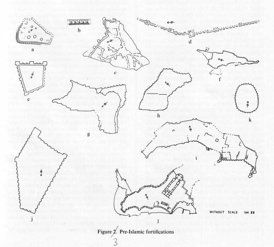
In Iran such fortified settlements and fortress complexes were understood as early as the 3rd millennium B.C. For example, in Azerbaijan it has been possible to take measurements at the fortress of Bolūrābād (Figure 3a), on the northern edge of the Qarā Żīāʾ-al-Dīn plain north of Ḵᵛoy (Kleiss, 1975). The outer walls of this fortress can be traced on a rock platform at the base of a mountain rising high above the plain; the obviously unfortified settlement area, with several partly rounded residential ground plans, was located on the plain itself. The fortress was 90 m long and 65 m wide, and its rounded triangular plan conforms to the shape of the site. The original fortress wall, consisting of a rubble core faced with large unworked boulders, was 3 m thick; no lime mortar was used as bonding agent. There were no projecting towers on either the interior or the exterior. Within the walls the ruins of some circular buildings are recognizable. In a second building phase the most vulnerable portion of the fortress wall, on the northeast, north, and northwest, was strengthened by the addition of a kind of chambered construction: About 3 m in front of the original defensive wall a second wall, about 1 m thick and also without towers, was erected; a series of cross walls were bonded to it but merely abutted the inner wall. The small chambers thus defined were filled with stones and earth, an economical way of strengthening and heightening the defensive perimeter. Both building phases of Bolūrābād can be ascribed to the 3rd millennium B.C. on the basis of ceramic finds. This type of chambered construction was already known in the 5th millennium B.C. at Zāḡa (Saqqezābād; Figure 3b) on the plain south of Qazvīn, where the temenos wall of a temple precinct was reinforced by means of such a secondary construction.
The fortified settlement of Rāvāz (Figure 3c) southwest of Mākū is 258 m long and 185 m wide, laid out on a triangular basalt platform above two converging tributaries; it also was established in the 3rd millennium B.C. and contained round houses typical of the residential and settlement forms of the time. The individual farmyards were linked only by walls along the edge of the platform. On the east side, where there were no natural defenses, a defensive wall, of unmortared rubble 4 m thick below and of mud brick above, was built with several niches, and there was also an outer ward 15 m long with an entrance gate. In the 3rd or 2nd millennium B.C. the wall was reinforced through the addition of massive, boldly projecting semicircular towers and corner buttresses. This innovation reflected advances in defensive techniques, particularly the tactic of subjecting attackers to crossfire from the sides.
From this developmental stage on, wall towers continued to be used and through the centuries were greatly developed. At the citadel of Ḥasanlū IV (Figure 3d), dated to the period of the so-called “burned buildings” in the early 1st millennium B.C. (before 800 B.C.), the line of the wall was occasionally jogged to create rectangular projections that looked very much like towers.
Urartian castles. In the 9th and 8th centuries B.C. Urartian builders made fundamental contributions to the development of fortress architecture in the Near East. They adapted Mesopotamian fortification methods to the landscape of their own settlement area, the so-called Armenian highlands, but a further advance can also be observed. In this early period Urartian fortresses were erected without regard to the natural terrain, according to a predetermined plan, so that heavy walls and high terraces were frequently necessary. Plain facades predominated, buttressed and defended by massive towers at the corners and along the walls, as at Qaḷʿa-ye Sīāh (Figure 3e), a castle constructed on a flat lava field 36 km east of Māku (Kleiss, 1973). Spaced at regular intervals along the wall between the projecting rectangular towers (which looked somewhat like bastions) there were flat pilasters, which had no defensive or structural function but served only the esthetic purpose of articulating the wall surface. Architectonic devices were thus combined with purely military features, so that even very early Urartian fortresses possessed an undeniable artistic power, underscoring their significance as “royal buildings.” The largest Urartian fortress on Iranian soil, Rusa-i Uru.Tur (Bastam, Besṭām, q.v.), built in the 7th century B.C., is a typical example of later Urartian fortress architecture. The plan (see BEṢTĀM; Figure 3f; cf. Kleiss, 1977b, I, pp. 14-15), which underwent three main building phases in only about fifty years, was entirely determined by the terrain. This Urartian fortress functioned as both religious and economic center for the region and as the seat of provincial government, with the related function of royal residence. Nevertheless, its primary purpose was as a strong castle, encompassing a graduated series of defensive terraces. The massive old Urartian towers with intervening narrow pilasters had developed at Besṭām into a series of equally spaced projections, which also served to articulate the walls. The site has been almost entirely excavated, and it is thus possible to distinguish the functions of the individual sections of the castle. The lower citadel, with the southern entrance, served the military garrison and included a guest house, as well as equipment storerooms and stables. The somewhat higher middle citadel contained reception rooms, the area of the Haldi temple, and extensive storerooms. The upper citadel, on the pinnacle of the mountain, was the governor’s residence and the last refuge in an attack.
The castle at Besṭām was the last major Urartian construction. In the 6th-5th century B.C. a different kind of defensive system made its appearance in Iranian fortress architecture, with the introduction of the zigzag wall without towers. The remains of Qaḷʿa-ye Gavūr (Kleiss, 1978b, pp. 34ff.; Figure 3g), southwest of Ḵᵛoy, include, in addition to Urartian and medieval building phases, a noteworthy phase dating from the 6th-5th centuries B.C., which is perhaps to be connected with the Medes.
Achaemenid, Parthian, and Sasanian castles. The Achaemenid method of building castles can still be recognized in its most coherent form at Persepolis (Figure 3h). The significant architectural and sculptural features of the palace have been thoroughly studied, but Persepolis was also a strong fortress, and this aspect is very little known. The fortifications have been partly excavated, and a detailed plan of the outer walls has been prepared (Kleiss, 1971). The section of the wall along the Kūh-e Raḥmat follows an irregular line conforming to the contours of the terrain. It was constructed largely of mud brick incorporating different levels of the cliff, just as the early Urartians had incorporated cliffs into the foundations of their structures. Large rectangular towers, modeled on those of the stone foundation of the palace terrace, project strongly from the wall. The walls contain passages, and there are rooms in the towers. With the massive rectangular towers and their projecting articulations, the entire structure is imposing, clearly meant to be recognized as a royal fortress. Rectangular towers continued to predominate until the late Achaemenid period, but in about the 4th century B.C. they began to be displaced by semicircular towers, reflecting a further advance in defensive techniques, eliminating to some extent the “blind spots” created by corners.
In contrast to this “royal” type of Achaemenid fortress are the castles in the countryside, the earliest of which were built at the end of the Achaemenid period or, more probably, in the Seleucid period after the downfall of the Achaemenid empire. In this interval, during which Hellenistic culture and architecture penetrated Iran, the more “modern” semicircular tower seems to have definitively replaced the old Mesopotamian rectangular tower. The development is clear at Qaḷʿa-ye Gavūr (Kleiss, 1976; Figure 3i) on the Araxes river east of Jolfā, where a fortress originally constructed on the Urartian system was completely reconstructed in the Median-Achaemenid period (6th century B.C.) with rectangular bastions and, finally, a short time later was provided with heavy round towers, which provided better protection against such highly developed attack weapons as catapults.
The old system of articulating the wall surface by means of projections and large corner towers nevertheless continued into the early Parthian period, as in the fortress at old Nisa in the Russian Transcaucasus of the 3rd century B.C. (Figure 3j).
Sasanian fortress plans generally include heavy, strongly projecting semicircular or parabolic towers spaced closely around the walls and serving both as defenses and to underscore the invulnerability of such structures. At Taḵt-e Solaymān (Naumann, 1977, II, Beilage 2; Figure 3k), a fortified temple in Azerbaijan, the heavy walls follow the natural configuration of the land, whereas the later Sasanian fire temple and lakeside structures at the same site follow predetermined plans.
Fortification with heavy round towers continued to develop in the Sasanian period, as did the “chamber” system, especially in earlier Sasanian structures like Qaḷʿa-ye Doḵtar near Fīrūzābād (Huff, 1976; Figure 21), the wall of which also followed an irregular line.
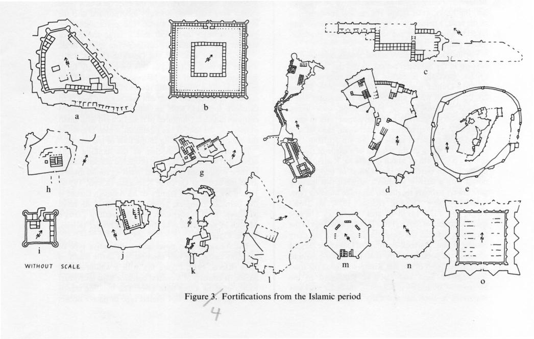
Early medieval castles. Fortification with heavy round towers appears in more developed form in early medieval Armenian castles in Azerbaijan, like Qaḷʿa-ye Ḥājestān, a medieval castle of the 4th-5th/10th-11th centuries standing on the remains of a castle of the 6th century B.C. north of Mākū (Figure 4a; Kleiss, 1979a, pp. 290ff.). In particular the method of building the portal with a narrow approach between two massive gale lowers strongly recalls the Sasanian building type.
Qaḷʿa-ye Sīj-e Dokkān (Kleiss, 1974, pp. 215ff.; Figure 4b), 152 x 151 m in area, overlooks a crossroads southeast of Sar(-e) Pol-e Ḏohāb; it belongs to the transition between the Sasanian empire and the early Islamic period. The rock-cut tomb of Dokkān-e Dāwūd stands at the point where the road from Qaṣr-e Šīrīn to Kermānšāh (part of the Silk Route) intersects the road from Qaṣr-e Šīrīn and Qaḷʿa-ye Yazdegerd to the Saymara valley and on to Ḵūzestān; the latter road was important in Sasanian and early Islamic times, as is attested by remains of large bridge constructions in the Saymara valley. The construction methods and vault types at Qaḷʿa-ye Sīj-e Dokkān conform to Sasanian building practices, but the almost square plan with its single entrance portal corresponds to that of an early Islamic robāṭ (fortified hospice), exemplifying adaptation of the robāṭ system to military architecture. Ceramic finds do not permit a precise determination of period.
Throughout the Middle Ages castles and citadels continued to be built in Iran. Examples of the former were to be found throughout the countryside, along the more important connecting roads, for example, and guarding important river crossings. Among citadels those in the cities of Kermān, Ḵorramābād, and Shiraz are particularly noteworthy.
Assassin castles. Among the largest and also, from the point of view of fortifications, most interesting castles are those of the Ismaʿili followers of Ḥasan Ṣabbāḥ, the so-called Assassins. The command center of this Shiʿite sect, on the peak of Alamūt (q.v.; Kleiss, 1982; Figure 4c) in the Alborz range, is largely ruined, but the system of fortifications, which is typical of the 5th-7th/11th-13th centuries, is still recognizable. The inner fortress consisted essentially of three complexes, which were linked by courtyards.
One of the best-preserved Assassin castles is Lamasar (Kleiss, 1982; Figure 4d) north of Qazvīn near Šāhrūd. There it is clear that the Assassins’ castles were in no sense residences for the gentry but were rather purely military installations with barracks for the garrisons. Natural features of the cliffs on which these castles were built were carefully incorporated into the design of the defensive works. The portals were especially strongly defended, and a large number of cisterns helped to make the castles secure against siege.
The Assassin castle on the Gerdkūh (Kleiss, 1981;Figure 4e) west of Dāmḡān was very strongly fortified and, as is clear from historical events, held out against Mongol attacks until the middle of the 7th/13th century. A prominent steep cliff outcropping had been carefully fortified, with an especially well-defended entrance passage; connected to it was a ward with small outposts at the foot of the mountain, which prevented the enemy from advancing to the foot of the citadel.
For more effective defense of the flanking walls occasional sections of the wall projected perpendicularly; these projections culminated in strong round towers, as at the castle at Qāʾen in Khorasan (Kleiss, 1977a; Figure 4f). A striking feature of all Assassin castles is the barracks complex, consisting of series of small rooms encircled by corridors, as at the castle of Ṭabas-e Masīnā in Khorasan near the Afghan border (Kleiss, 1977a; Figure 4g).
The Assassins also developed a distinctive type of barracks castle; the best example is a castle south of Sāva (Kleiss, 1972; Figure 4h), with a well-preserved palace. It consists of a central corridor with individual rooms opening along both sides. The building stands on a high foundation. A similar type of palace occurs in the Assassin castle at Šamīrān on the Safīdrūd west of Manjīl.
Castles on caravan routes served to defend and guard travelers and their merchandise. Such strong defensive points were located in the desert near caravansaries like the 12th-13th/18th-19th century example at Elāhābād, on the road from Yazd to Ṭabas (Kleiss, 1981a; Afšār, p. 187; Figure 4i). Located about 40 km southwest of Robāṭ-e Pošt-e Bādām, it stands with one rear tower on a steep cliff; as it is much taller than the others, it served as a watch tower.
A much older large castle on the old caravan route from Varāmīn to Qom, Qaḷʿa(-ye) Gelī near Kaj (Kleiss, 1981a, pp. 103ff.; Figure 4j), has massive rectangular towers defending the main portion of the castle. It can be recognized as of Sasanian type, but nevertheless it was built no earlier than the early Islamic or even the Saljuq period, as was the neighboring caravansary of Robāṭ-e Qaḷʿa(-ye) Sangī. In the later Islamic period a second wall was added at the foot of the mountain section; parts of it are still preserved.
The castle of Balada (Figure 4k) in the Nūr valley also guarded a caravan stop, Pā-Kabūd-Balada, where the east-west road running through the valley intersected a road from Tehran that crossed the mountains via the upper Lār valley and continued north to the coast of the Caspian Sea near Maḥmūdābād. This castle is built on a steep cliff outcropping, and its portal structure is extremely well defended, both from the ward outside and from the passage between the ward and the main fortifications.
From the early Islamic period in the 1st/7th century until the modern period fortified castles in Iran have generally been adapted to new developments in weapons and defensive techniques; larger, more closely spaced round towers were built, and devices for preventing assault were built farther forward, in order to make it more difficult for attackers to reach the walls with scaling ladders.
Strong fortresses were also frequently built to guard important river crossings. For example, the fortress of Qaḷʿa-ye Doḵtar (Kleiss, 1969, pp.74ff.; Figure 3l), east of Mīāna in Azerbaijan, guarded a bridge over the Qezel Ozon (Qızıl Uzun; Pol-e Doḵtar or Pol-e Qāflānkūh). Here the massive cliff was incorporated into the plan of the fortress walls with consummate skill (Figure 4l). On the highest point of the fortress stands a palace that can be compared with the corresponding structures in the castles of the Assassins at Sāva and Šamīrān on the lower course of the Qezel Ozon, which suggests that Qaḷʿa-ye Doḵtar near Mīāna was probably also an Assassin castle. It would thus have belonged to a series of related constructions located between the center of the sect in the Alamūt valley and the Ismaʿili castles in Syria.
In the Safavid period in the 11th/17th century an octagonal castle, Mīānqaḷʿa (Kleiss, 1981, pp. 139ff.; Figure 4m) was built on the Astarābād peninsula in the Caspian Sea; it has large, octagonal towers, in which European influence can be recognized, as also in the towers of Faraḥābād (Kleiss, 1982), the summer residence of Shah ʿAbbās on the Caspian Sea. On the other hand, an eight-sided castle at Qūščī (Figure 4n), on the western shore of Lake Urmia 43 km north of the town of Urmia (Reżāʾīya) must be dated on the basis of ceramic finds to the Il-khanid period (654-754/1256-1353). It is octagonal in plan but with normal semicircular projecting towers.
Finally, at the beginning of the 13th/19th century bastions were introduced into Iran by European military advisers, and the walls of larger cities—most notably Tehran and Ḵᵛoy—were provided with them, as were a few fortresses in the countryside, among others Qaḷʿa-ye Kohna (Kleiss, 1980, pp. 174ff.; Figure 4o northwest of Kermānšāh and a castle south of Ahar (Kleiss, 1982, pp. 389ff.). At Qaḷʿa-ye Kohna an inner walled building is combined with outer earthworks and acute-angled bastions, a military plan based on European practice. Qaḷʿa-ye Kohna is nevertheless considered to be an example of Iranian fortress architecture constructed according to modern, that is, imported, ideas, in contrast to the Portuguese fortresses on the road from Hormoz and the Dutch fort on Ḵārg island.
Bibliography:
Ī. Afšār, Yādgārhā-ye Yazd I, Tehran, 1348 Š./1970.
D. Huff, “Ausgrabungen auf Qaḷʿa-ye Dukhtar 1975,” AMI, N.S. 9, 1976, pp. 157-73.
W. Kleiss, “Bericht über zwei Erkundungsfahrten in Nordwest-Iran,” AMI, N.S. 2, 1969, pp. 7-119.
Idem, “Die Felsabtreppungen von Persepolis,” Mitteilungen der Deutschen Orient-Gesellschaft 103, 1971, pp. 69-76.
Idem, “Bericht über Erkundungsfahrten in Iran im Jahre 1971,” AMI, N.S. 5, 1972, pp. 135-242.
Idem, “Planaufnahmen urartäischer Burgen in Iranisch-Azerbaidjan im Jahre 1972,” AMI, N.S. 6, 1973, pp. 81-89.
Idem, “Die Festung Qaleh Seidj Dukkan bei Sarpol-i Zohab in West-Iran,” AMI, N.S. 7, 1974, pp. 215-21.
Idem, “Bolurabad. I. Die Architektur,” AMI, N.S. 8, 1975, pp. 15-20.
Idem, “Zwei Plätze des 6. Jahrhunderts v. Chr. in iranisch Azerbaidjan. A. Die Bauten,” AMI, N.S. 9, 1976, pp. 107-16.
Idem, “Burganlagen und Befestigung in Iran,” AMI 10, 1977a, pp. 23-52.
Idem, Führer zu archäologischen Plätzen in Iran, 2 vols., 1977b.
Idem, “Hügelgräber in Nordwest-Azerbaidjan,” AMI 11, 1978, pp. 13-18.
Idem, “Urartäische Plätze. A. Architektur,” AMI 11, 1978b, pp. 27-59.
Idem, “Früharmenische Burgen in Nordwest-Azerbaidjan. A. Architektur,” AMI 12, 1979a, pp. 289-98.
Idem, “Ravaz und Yakhvali, zwei befestigte Plätze des 3. Jahrtausends. A. Architektur,” AMI 12, 1979b, pp. 27-34.
Idem, “Europäische Befestigungsarchitektur in Iran vom 16. bis zum 19. Jahrhundert,” AMI 13, 1980, pp. 167-78.
Idem, “Mittelalterliche Burgen im Zentraliranischen Hochland,” AMI 14, 1981a, pp. 95-116.
Idem, “Die safavidische Festung Meyan-Qaḷʿeh in Mazanderan,” AMI 14, 1981b, pp. 139-42.
Idem, “Mittelalterliche Burgen im Elburzgebirge und südlich von Qom,” AMI 15, 1982a, pp. 237-85.
Idem, “Die safavidische Sommerresidenz Farahabad am Kaspischen Meer,” AMI 15, 1982b, pp. 347-60.
Idem, “Inselfestung im Sefid Rud nördlich Rudbar,” AMI 20, 1987, pp. 323-25.
S. A. Matheson, Persia. An Archaeological Guide, 2nd ed., London, 1976.
C. O. Minasian, Shah Diz of Ismai’li Fame. Its Siege and Destruction, London, 1971.
R. Naumann, Führer zu archäologischen Plätzen in Iran, II, Berlin, 1977.
L. Vanden Berghe, Bibliographie analytique de l’archéologie de l’Iran ancien, Leuven, 1979; with E. Haerinck, Supplément 1: 1978-1980, 1981; Supplément 2: 1981-1985, 1987.
P. Willey, The Castles of the Assassins, London, 1963.
(Wolfram Kleiss)
Originally Published: December 15, 1990
Last Updated: December 15, 1990
This article is available in print.
Vol. V, Fasc. 1, pp. 65-70