


BRIDGES (Pers. pol, Mid. Pers. pohl, Av. pərətu-)
ii. Bridges in the Islamic period.
Bridges may have existed in the Iranian highlands as monuments of vernacular architecture since prehistoric times; they were probably constructed, as they still are today, of timber girders or even suspended between abutments consisting of piled-up stones. There seem to be traces of an early bridge across the Araxes at the Urartian site of Veraḵram (Kleiss, 1974, pp. 84f.). The use of boat bridges is reported by Herodotus (7.5ff., 36ff.), who mentions those that Xerxes had laid across the river Strymon and the Hellespont.
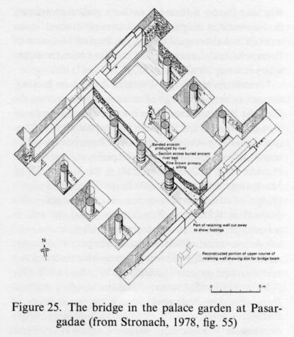
Substantial archeological evidence of bridges in Iran begins in the Achaemenid period, however. The model may have been the bridge across the Euphrates at Babylon, which was built in the time of Nabupolassar (625-605 b.c.) or Nebuchadnezzar (604-562 b.c.; Plate xxi); it consisted of a wooden superstructure on stone piers (Koldewey, p. 193; Wetzel, pp. 54, 77-78, pl. 51). A bridge was excavated in the palace gardens at Pasargadae, where it crossed a canal ca. 2 m deep. Three rows of five stone columns each carried a platform probably built of wood; each span was ca. 3.90 m, the total length 15.65 m, and the width nearly 16 m. The dimensions indicate that it was intended as something more than a simple crossing. It has been dated to the late Achaemenid or even post-Achaemenid period (Stronach, 1965, p. 29; idem, 1978, p. 113; Figure 25). There are several barrages on the Kor west of Persepolis that are thought to be of Achaemenid date. Bard-e Borīda II near Dorūdzan is a causeway, pierced by five openings for water to pass through, each 1.50 m wide and 1.85 m high; the corners are rounded and faced with long blocks of stone in order to facilitate the flow. A road 5.50 m wide ran on this causeway to a bridge that is now destroyed; it probably consisted of stone piers and a wooden superstructure. The stone-cutting technique and details of the metal clamps used to join the blocks suggest a 5th-century B.C. date.
Some distance upriver are remains of the sluice gate for an ancient canal; the structure is known as Band-e or Sang-e Doḵtar. It has two openings with sharply pointed arches ca. 3 m wide and 2 m high cut through a natural spur of rock; the superstructure is built of stone blocks. Socket holes and grooves show that originally there was an apparatus for opening and closing the gates. The structure has been dated to the Achaemenid (Bergner, p. 1; Tilia, 1972, p. 69; idem, 1978, p. 73), Sasanian, and even Islamic (Nicol, pp. 254-63) periods. During removal of the monument to another site it was observed that the bridge abutment contains stone blocks worked in the Achaemenid manner, either in original or reused context (Tilia, 1978, p. 73). There is also evidence of a paved Achaemenid road running west from Persepolis across Bard-e Borīda II. Other barrage constructions on the Kor, like Bard-e Borīda I, have been almost completely destroyed. An enigmatic structure of dressed stone worked in Achaemenid technique, located 3 km west of Persepolis, may have provided passage for water within a larger complex (Tilia, 1978, p. 84, figs. 33ff.).
Material evidence for Parthian bridges is lacking, though an arched bridge of stone and brick across the Tigris at Parthian Ctesiphon is mentioned by medieval authors, whereas the Sasanian bridges connecting Ctesiphon and Beh-Ardašīr are said to have been wooden constructions, probably on stone piers, or boat bridges (Streck, 1900, p. 269; idem, 1917, p. 37; Fiey, p. 11; cf. Markwart, Provincial Capitals, p. 72, mentioning a bridge of about twenty boats across the Masroqān channel in Ḵūzestān). Extensive imperial, as well as private, programs of constructing bridges, dams, and canals are attested for the Sasanian period. Already Ardašīr I (a.d. 224-41) was renowned for his irrigation and drainage projects (Nöldeke, p. 47). Bahrām V Gōr (420-38) is reported to have used the building material from churches destroyed during his persecution of Christians in the construction of aqueducts and bridges over canals (Hoffmann, p. 40) and Ḵosrow I (531-79) to have repaired every bridge of wood or stone that had been damaged during the Mazdakite revolution (Nöldeke, Geschichte der Perser, p. 164). After the emperor Valerian’s army was defeated and captured by Šāpūr I in 260, Roman prisoners of war were employed for construction work in Ḵūzestān and had an influence on Iranian civil-engineering techniques that was unparalleled in any other branch of architecture (Nöldeke, Geschichte der Perser, p. 32; Masʿūdī, Morūj I, p. 227; Šāh-nāma, ed. Mohl, V, p. 393; Ṯaʿālebī, Ḡorar, pp. 494, 527; Nozhat al-qolūb, ed. Le Strange, p. 107).
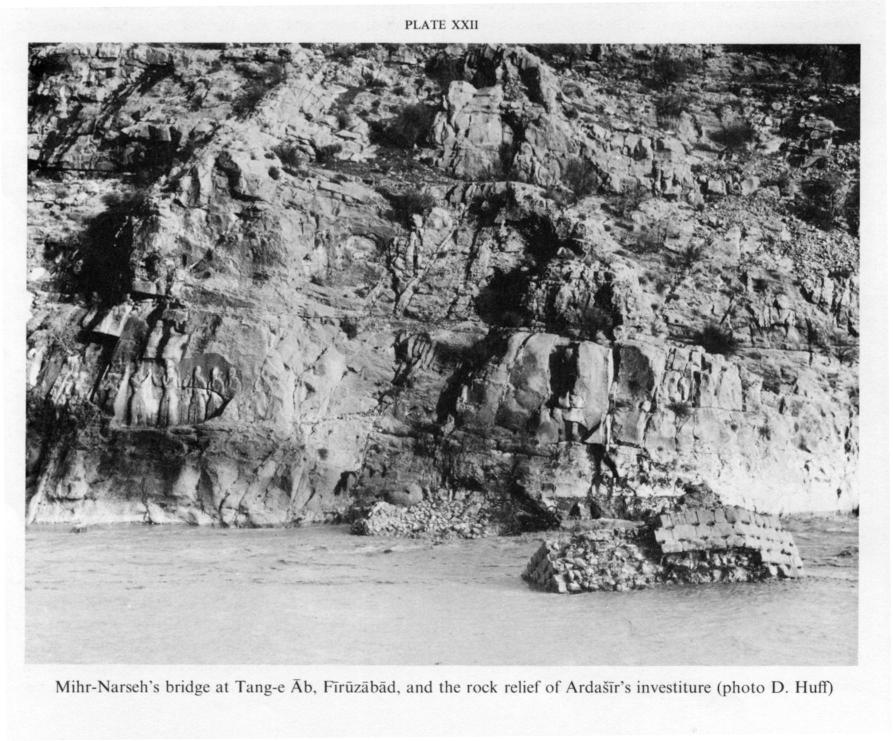
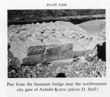
The bridge of Roman type at Fīrūzābād (Ardašīr Ḵorra), which was long thought to date from as early as the time of Ardašīr I, has turned out to belong to the first half of the 5th century. A corrected reading of its foundation inscription shows that it was built at the order of Mihr-Narseh, wuzurg-framadār (grand vizier) of Yazdegerd I (399-420), Bahrām Gōr (420-38), and Yazdegerd II (438-57). The text suggests that endowment of a bridge was regarded as an act of religious and social merit (Forṣat-al-Dawla Šīrāzī, p. 121, fig. 14; Ghirshman, 1947, p. 5; Henning, pp. 98f.; Bier, 1986, p. 263). Mihr-Narseh’s bridge crossed the Tang(-e) Āb on the main access road to Ardašīr-Ḵorra, below the fortress of Qaḷʿa-ye Doḵtar and immediately beside the rock relief of Ardašīr’s investiture (Plate xxii). One pier is preserved, partly tipped over, in the river. Its pentagonal plan consists of an approximate square 6.35 by 6.50 m and a triangular cutwater pointing upstream, for a total length of ca. 9.70 m. The material is rubble concrete of stones and lime mortar faced with cut blocks well embedded in the core and held together by leaded iron clamps. About 18 m away, on the sandy bank below Qaḷʿay-e Doḵtar, traces of a causeway and bridge abutment are visible; on the opposite bank, 15 m away, a shapeless mass of concrete is attached to the precipice wall by means of iron clamps bedded in the living rock. There is no trace of intermediate piers. Arches of stone and brick may therefore be assumed. As the bridge is built perpendicular to the side of the gorge, the road must have made a 90-degree turn and descended on an artificial ramp, passing directly below the investiture relief of Ardašīr. Mihr-Narseh must have chosen this site for his bridge, with its accompanying inscription, deliberately in order to rival this relief, for there are more convenient points at which to cross the river. Two piers and a weir construction, known as Pol-e Bandar, are preserved some kilometers downstream. The dimensions of the piers are nearly identical with those of Mihr-Narseh’s bridge; the masonry, however, is much inferior and not joined by clamps. A Sasanian date is possible, though not certain (Huff, p. 155). A third bridge of definitely Sasanian date that crosses the river immediately before the northwestern gate of the round city of Ardašīr-Ḵorra, had been badly damaged by floods already in ancient times (Plate xxiii). It was overbuilt by another bridge with hexagonal piers in later Sasanian or, more probably, Islamic times reusing ancient material. At Bīšāpūr the southeast-northwest axis of the city was extended across the Šāpūr river outside the city gate by a bridge supposedly on two arches. Only the mutilated cores of its abutments still stand on the riverbanks; they are made of stone rubble and lime mortar. This bridge obviously belongs to the original plan of the city and can thus be dated to the reign of Šāpūr I (241-72; Ghirshman, 1971, p. 30).
In Ḵūzestān, bridges like those at Šūštar, Dezfūl, Pā-ye Pol, and Ahvāz have long been of special interest because of their impressive dimensions and historical implications. The rather schematic documentation shows that they all have piers on a pentagonal plan, similar in shape and construction to those of the Fīrūzābād bridges. All were barrages or weirs of several arches, used both for the passage of water and for irrigation. Those at Šūštar and Dezfūl are still in use, having undergone extensive repairs or reconstructions over the centuries, and scarcely any trace of the original superstructures is preserved (Dieulafoy, V, p. 105; Roggen, p. 166; Kleiss, 1981, p. 146; Stein, p. 171). A water tunnel was bored through the foundation embankment of the bridge at Jondīšāpūr, obviously in order to carry water to the city from the distant Dez river under the bed of the intermittent Sīāh Manṣūr. The eight piers of this bridge have wedge-shaped cutwaters like the earlier ones, but with rounded or faceted projections downstream, demonstrating a hydrodynamic improvement that had already been achieved in the bridge at Babylon. A late Sasanian date has been suggested (Adams and Hansen, p. 59). Yaʿqūbī (tr. Wiet, p. 361) reports a bridge of boats in 3rd/9th-century Jondīšāpūr; it may, however, have been located on the Dez.
A considerable number of supposedly Sasanian bridges has been reported from the Zagros provinces bordering Ḵūzestān on the north and east. In the north the Ṣaymara river was crossed at two points by bridges that are now badly ruined: the Pol-e Ḵosrow next to the Safavid bridge at Gowmīšān and, farther upstream, the Pol-e Āb-borda. The famous Pol-e Doḵtar on the tributary Kāšgān river is certainly of the early Islamic period but had an obvious predecessor nearby, for which even a pre-Sasanian date has been discussed (Stein, pp. 182, 190, 212). Farther upstream there is a barrage with twenty-six piers on the southern outskirts of Ḵorramābād. The piers have cutwaters on a triangular plan on both the upstream and downstream sides. The six preserved pointed arches are considered to be medieval reconstructions (Kleiss, 1975, p. 136). To the east, near Behbahān, several bridges and barrages of supposedly Sasanian origin are reported at Ḵayrābād-e Pāʾīn (lower bridge), Ḵayrābād-e Bālā (upper bridge), and Arrajān (Pol-e Doḵtar). Farther up the Shiraz road, at the spectacular Tang-e Bārīn crossing, the uppermost of three bridge ruins may be Sasanian as well. The same dating is accepted for constructions like the Pol-e Mūrd between Ardakān and Fahlīān, whereas the second bridge at Pātāva near Yāsūj, in view of its small-scale type masonry, its mason’s marks, and the obviously original inscription of “yā ʿAlī,” is likely to be Islamic (Stein, pp. 15, 48, 70, 80, 140; Gaube, pp. 178, 187, 210, 211; Kleiss, 1981, pp. 20, 148, 153). The location and reconstruction of the legendary Qanṭara Ḵorrazād on the road from Īḏa/Malāmīr to Isfahan, which has been attributed to a Sasanian queen, are still hypothetical (Schwarz, Iran, p. 338; Hansman, p. 46).
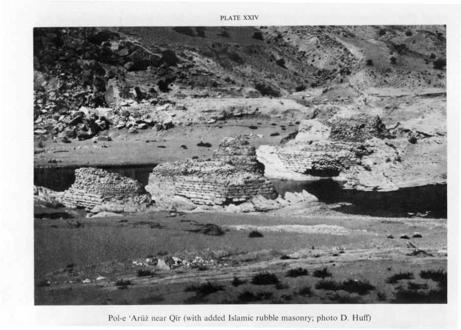
At Bīsotūn, on the Iranian plateau, there is an obviously late Sasanian bridge, Pol-e Ḵosrow, across the Gāmāsīāb, its date being certain because of its connection with the extensive construction program at the site. Nine piers of rubble concrete faced with cut stone have cutwaters on a triangular plan on both upstream and downstream sides, a technical step forward from the early Sasanian bridge type at Fīrūzābād, which can also be observed on the Pol-e ʿArūż at Qīr (Plate xxiv) and the bridge at Ḵorramābād as well. The superstructure is, as usual, missing (Golzārī, p. 70; Matheson, p. 152, fig. 49a; Luschey).
Altogether the number of definitely Sasanian bridges is rather limited and the documentation scarcely sufficient to establish a valid inventory of stylistic and technological features. The use of cut stone blocks for facing the piers was not limited to the Sasanian period, and, despite the general opinion that Sasanian bridges were more solidly constructed, there is not enough detailed information on masonry to permit it in all cases to be taken as a diagnostic feature. Metal clamps seem to have been abandoned after the Sasanian period, but there is no certainty that they were obligatory even in Sasanian structures. As gypsum mortar, which was preferred in Iranian architecture, is soluble in water, lime mortar would normally be expected as the bonding agent in bridges, it is reported from Bīšāpūr and Ḵorramābād, and chemical analysis of mortar from Mihr-Narseh’s bridge at Fīrūzābād showed consistent use of lime with normal impurities for the piers, whereas gypsum was used for the causeway (Technical and Soils Laboratory of the Iranian Ministry of Roads, Tehran, April 1976). Piers on a pentagonal or hexagonal plan, with triangular cutwaters pointing upstream and, in later examples, on both sides, seem to be typical of Sasanian bridges, though they can be found on later examples as well; on the other hand, rounded projections and buttresses on a semicircular plan seem to appear only in the Islamic period.
Although the superstructures have largely vanished, wooden girders have been suggested for most Sasanian bridges, for example, those at Jondīšāpūr and Ḵorramābād, because of their rather short spans. Taking into account the scant supply of good timber in Iran, on one hand, and the knowledge of advanced vaulting techniques, on the other, it seems more probable that stone or brick vaults were commonly used to span the piers. An important aspect of early Iranian bridges in general is the part that barrages or weirs played, owing to the need for irrigation. The relative rarity of bridges designed solely for traffic may be explained by such interrelated factors as the almost exclusive use of pack animals, rather than carts, for transport and the fordability of most rivers during most of the year.
Bibliography
R. M. Adams and D. P. Hansen, “Archaeological Reconnaissance and Soundings in Jundi Shapur,” Ars Orientalis 7, 1968, pp. 53-73.
K. Bergner, “Bericht über unbekannte achaemenidische Ruinen in der Ebene von Persepolis,” AMI 8, 1936-37, pp. 1-4.
L. Bier, “Notes on Mihr Narseh’s Bridge at Firuzabad,” AMI 19, 1986, pp. 263-68.
M. Dieulafoy, L’art antique de Perse V, Paris, 1889.
J. M. Fiey, “Topography of al-Madāʾin,” Sumer 23, 1967, pp. 3-36.
Mīrzā Moḥammad-Naṣīr Forṣat-al-Dawla Šīrāzī, Āṯār-e ʿAjam, Bombay, 1314/1896.
H. Gaube, Die südpersische Provinz Arrağan/Kuh-Giluye von der arabischen Eroberung bis zur Savawidenzeit, Vienna, 1973.
M. Golzārī, Kermānšāhān-e bāstān az āḡāz tā āḵer-e sada-ye sīzdahom-e hejrī-e qamarī, Kermānšāh, n.d.
R. Ghirshman, “Firuzabad,” Bulletin de l’Institut français d’archéologie orientale 46, 1947, pp. 1-28. Idem, Bichapour I, Paris, 1971.
J. Hansman, “Three Topographical Problems in the Southern Zagros,” BSOAS 36, 1973, pp. 43-54.
W. B. Henning, “The Inscription of Firuzabad,” Asia Major, N.S. 4, 1954, pp. 98-102.
G. Hoffmann, Auszüge aus syrischen Akten persischer Märtyrer, Leipzig, 1880.
D. Huff, “An Archaeological Survey in the Area of Firuzabad,” in Proceedings of the 2nd Annual Symposium on Archaeological Research in Iran, Tehran, 1974, pp. 155-79.
W. Kleiss, “Planaufnahmen urartäischer Burgen und Neufunde urartäischer Anlagen in Iranisch-Azerbaidjan im Jahre 1973,” AMI, N.S. 7, 1974, pp. 79-114.
Idem, “Vorislamische Ruinen im nördlichen Zagros,” AMI, N.S, 8, 1975, pp. 133-40.
Idem, “Safavidische und qadjarische Brücken in Iran,” AMI 14, 1981, pp. 143-60.
R. Koldewey, Das wiedererstehende Babylon, Leipzig, 1913.
H. Luschey, in EIr. IV/2, p. 294.
S. Matheson, Persien. Ein archäologischer Führer, 2nd ed., Stuttgart, 1980.
A. Neuburger, Die Technik des Altertums, Leipzig, 1919.
M. B. Nicol, “Rescue Excavations near Dorūdzan,” East and West 20, 1970, pp. 245-84.
T. Nöldeke, “Geschichte des Artachširî-Pâpakân,” Bezzenbergers Beiträge 4, Göttingen, 1878, pp. 22-69.
A. U. Pope, “Islamic Architecture. M: Bridges, etc.,” in Survey of Persian Art II, 1939, pp. 1226-41.
O. Reuther, “Sasanian Architecture,” in Survey of Persian Art I, 1938, pp. 493-578.
G. van Roggen, Notices sur les anciens travaux hydrauliques en Susiane, MDAFI 7, Paris, 1905.
Sir M. Aurel Stein, Old Routes of Western Iran, London, 1946.
M. Streck, Die alte Landschaft Babylonien nach den arabischen Geographen, Leiden, 1900.
Idem, Seleucia und Ktesiphon, Leipzig, 1917.
D. Stronach, “Excavations at Pasargadae. Third Preliminary Report,” Iran 3, 1965, pp. 9-40.
Idem, Pasargadae, Oxford, 1978.
A. B. Tilia, Studies and Restorations at Persepolis and Other Sites of Fars, 2 vols., Rome, 1972, 1978.
F. Wetzel, Die Stadtmauern von Babylon, Leipzig, 1930.
(Dietrich Huff)
ii. Bridges in the Islamic Period
Bridges constructed in Iran during the Islamic period, from the 1st/7th to the beginning of the 14th/20th century, will be treated here; modern steel and reinforced-concrete bridges will, however, not be considered.
The dating of Iranian bridges is in most instances very difficult, for usually neither historical texts nor building inscriptions are extant. In particular, it has been impossible so far to distinguish clearly between Sasanian and Islamic bridges. Old bridges are often rashly designated as Sasanian in the literature, especially if they stand on piers faced with well-dressed stone blocks joined by clamps (Matheson, p. 136). Two examples are Pol-e Doḵtar on the road from Ḵorramābād to Andīmešk and the bridge near Ḵorramābād. Frequently local vernacular seems to suggest a Sasanian foundation date that can certainly not be applicable to the total structure. Pol-e Doḵtar has thus sometimes been dated to the Sasanian period because it is also popularly known as Pol-e Šāpūr and it has been assumed that the bridge was erected by Šāpūr I (mid-3rd century). Remains of an older bridge a short distance downstream from Pol-e Doḵtar may well be a construction of Šāpūr I, but the portions of Pol-e Doḵtar that are still standing were certainly built in the 3rd-4th/9th-10th century, as the vaults over the piers clearly reveal. Massive piers like those on the bridge at Ḵorramābād may belong to the Sasanian period, but such dating cannot be demonstrated with certainty. Samples of mortar taken from the piers and vaults are of quite different consistency, hardness, and color; nevertheless, such differences allow no basis for dating, as they naturally reflect different requirements for parts of the bridge that have to withstand the flow of water and those that do not. Care must thus be exercised in suggesting Sasanian dates for old bridges in Iran, especially those that clearly carry Islamic superstructures.
Bridges in Iran can be divided according to two different construction systems: those on tapered piles and those carried on continuous embankments. The choice depends on the nature of the ground. On rocky or firm soil, gravel piles were used; on sandy soil, bridges were as a rule carried on embankments or dykes as protection against undermining and washouts. Both types go back to the Sasanian period and continued to be used into the 13th/19th century. Often the crossing was laid over an irrigation dam. The oldest example in Islamic Iran is the Band-e Amīr east of Shiraz, which was built by the Buyid ʿAżod-al-Dawla Fanā-Ḵosrow in the 4th/10th century (Kleiss, 1972, pp. 226f.)
Older bridge structures can also be categorized according to arched or girder construction; suspension bridges (on ropes) were used only on minor roads. Girder bridges played a subordinate role in Iran, occurring only in areas of the northwest that are relatively rich in wood. They were supported on stone piers and constructed of several layers of logs, each layer projecting farther toward the center of the span between piers; when completed, these structures could support continuous beams the full length of the bridge (Figure 25). Arched bridges were, however, by far the most common type constructed in the Islamic period in Iran until the 14th/20th century, when modern steel and reinforced-concrete truss bridges were introduced. The predominant arch form was the pointed arch, which in the early Middle Ages had a slightly parabolic profile (Figure 26). Early Islamic arches spanned only narrow intervals between piers, as at Pol-e Kāšgān, Somāq (dated by an inscription ca. 4th century/1000; A. Stein, pp. 271f., fig. 81), and Pol-e Kalhor inscribed in the 4th/late 10th century (Herzfeld, pp. 72ff., pl. ix). In subsequent centuries the intervals between piers tended to become wider and to be spanned by lower arches (Figure 26), as in Pol-e Qāflānkūh near Mīāna of the late 9th/15th century (Kleiss, 1983, pp. 363ff.).
In the 10th-11th/17th century bridge arches (Figure 26) echoed the general arch form of the period, with strongly curved haunches and somewhat flattened crowns, as in the bridges at Isfahan (Würfel, pp. 175ff.). This form did not change during the early and middle Qajar period. Only in the late Qajar period, in the early 14th/beginning of the 20th century, did pointed bridge arches approach more and more closely to rounded arches (Figure 26), obviously owing to European influence and modern methods of casting reinforced concrete. At approximately the same time, in the late Qajar and early Pahlavi periods, the basket-handle arch was introduced (Figure 26) in order to lower the total height of bridges to accommodate modern truck traffic (Kleiss, 1987).
In Iran there were a variety of constructions for carrying water across stream beds or other breaks in the terrain. They were built in the same way as bridges; for example, the aqueduct at Tang-e Dalūn in Fārs carries fresh water from a spring across the river to a caravansary on the stretch of road from Lār to Bandar-e ʿAbbās (Kleiss, 1986, fig. 14).
The forms of bridge piers were quite varied. They included piers on a rectangular plan flush with the sides of the bridge, without cutwaters. Cutwaters, facing either upstream or in both directions, were, however, more common. In Safavid bridges semicircular cutwaters are frequently found on both faces of the piers. A number of variations on all these pier plans was possible. In most bridges the weight of the piers was lessened by means of openings above the normal water line. When the streams were in flood, these tubes also permitted water to flow through, thus lessening the pressure of masses of water on the bridge structure. Especially in big bridges the load on the piers and the bridgeheads was lightened still further by means of hollow chambers set into the spandrels between the arches. These chambers, which were often on two levels, ran the full width of the bridge; they were joined to one another by staircases and served, when the water level was normal, as places for travelers to spend the night. Several bridges had rooms in the bridgeheads to accommodate travelers, as at Pol-e Anbū between Qazvīn and the Caspian coast (Kleiss, 1985, pp. 205ff.). On the bridgeheads of older bridges the parapets terminated at each end in brick-faced pillars the main function of which was to serve as fenders. Whether constructed of baked brick, rubble, or even occasionally of dressed stone blocks, bridges were very rarely articulated architectonically by niches on the wall facades or by single or multiple offsets framing the arches. Whether large or small, however, they were quite harmoniously proportioned.
E. Herzfeld, “Bericht über archäologische Beobachtungen im südlichen Kurdistan und in Luristan,” AMI 1, 1929-30, pp. 65-75.
W. Kleiss, “Bericht über Erkundungsfahrten in Iran im Jahre 1971,” AMI, N.S. 5, 1972, pp. 135-242.
Idem, “Pol-e Qaflan Kuh bei Mianeh,” AMI 16, 1983, p. 363.
Idem, “Brücken aus safavidischer und qadjarischer Zeit im nördlichen Iran,” AMI 18, 1985, pp. 205-40.
Idem, “Safavidische und qadjarische Brücken in Iran II,” AMI 19, 1986, pp. 313-38.
Idem, “Brücken aus safavidischer und qadjarischer Zeit in Südwest- und in Nordiran,” AMI 20, 1987 (forthcoming).
S. Matheson, Persien. Ein archäologischer Führer, 2nd ed., Stuttgart, 1980.
R. Pohanka, “Die historischen Bauwerke der Stadt Lar,” AMI 16, 1983, pp. 347-48.
M. A. Stein, Old Routes of Western Īrān, London, 1940.
Survey of Persian Art III, pp. 1226-41; VIII, pls. 491-93.
K. Würfel, Isfahan, Zurich, 1974.
Plate xxi. Bridge on the Euphrates at Babylon (from Wetzel, pl. 78.2)
Plate xxii. Mihr-Narseh’s bridge at Tang-e Āb, Fīrūzābād, and the rock relief of Ardašīr’s investiture (photograph D. Huff)
Plate xxiii. Pier from the Sasanian bridge near the northwestern city gate of Ardašīr-Ḵorra (photograph D. Huff)
Plate xxiv. Pol-e ʿArūż near Qīr, with added Islamic rubble masonry (photograph D. Huff)
Figure 25. The bridge in the palace garden at Pasargadae (from Stronach, 1978, fig. 55)
Figure 26. A girder bridge (above) and arch forms on bridges of different dates in the Islamic period