


BALUCHISTAN
i. Geography, History, and Ethnography
This article is divided into the following sections: 1. introductory review of problems in the history and ethnography of the Baluch, i.e., the present-day inhabitants of Baluchistan; 2. geography; 3. the origins of the Balōč, i.e., the people who brought the name into the area; 4. the early history of the area between Iran and India (Baluchistan); 5. the eastward migrations of the Balōč; 6. the establishment of the khanate in Kalat; 7. the autonomous khanate, 1666-1839; 8. the period of British dominance, 1839-1947; 9. the Baluch in Pakistan, Iran, and Afghanistan since 1947; 10. the diaspora; 11. ethnography. [Note: place names in Pakistan have not been transliterated.]
1. Introduction.
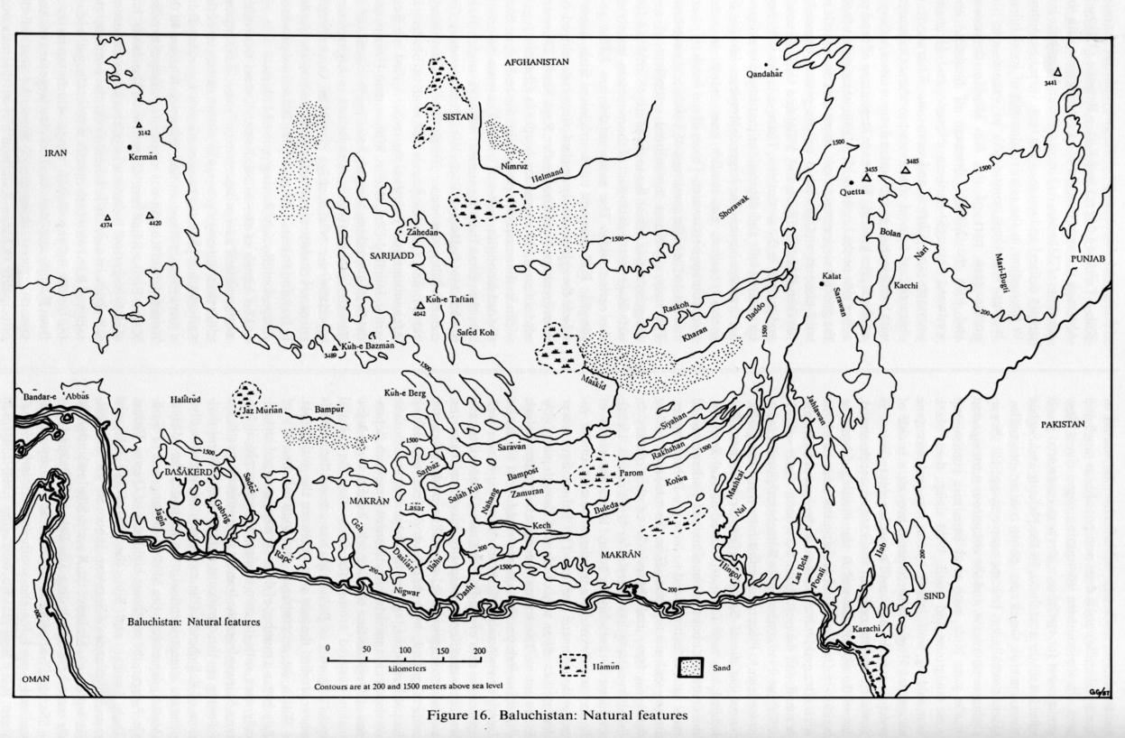
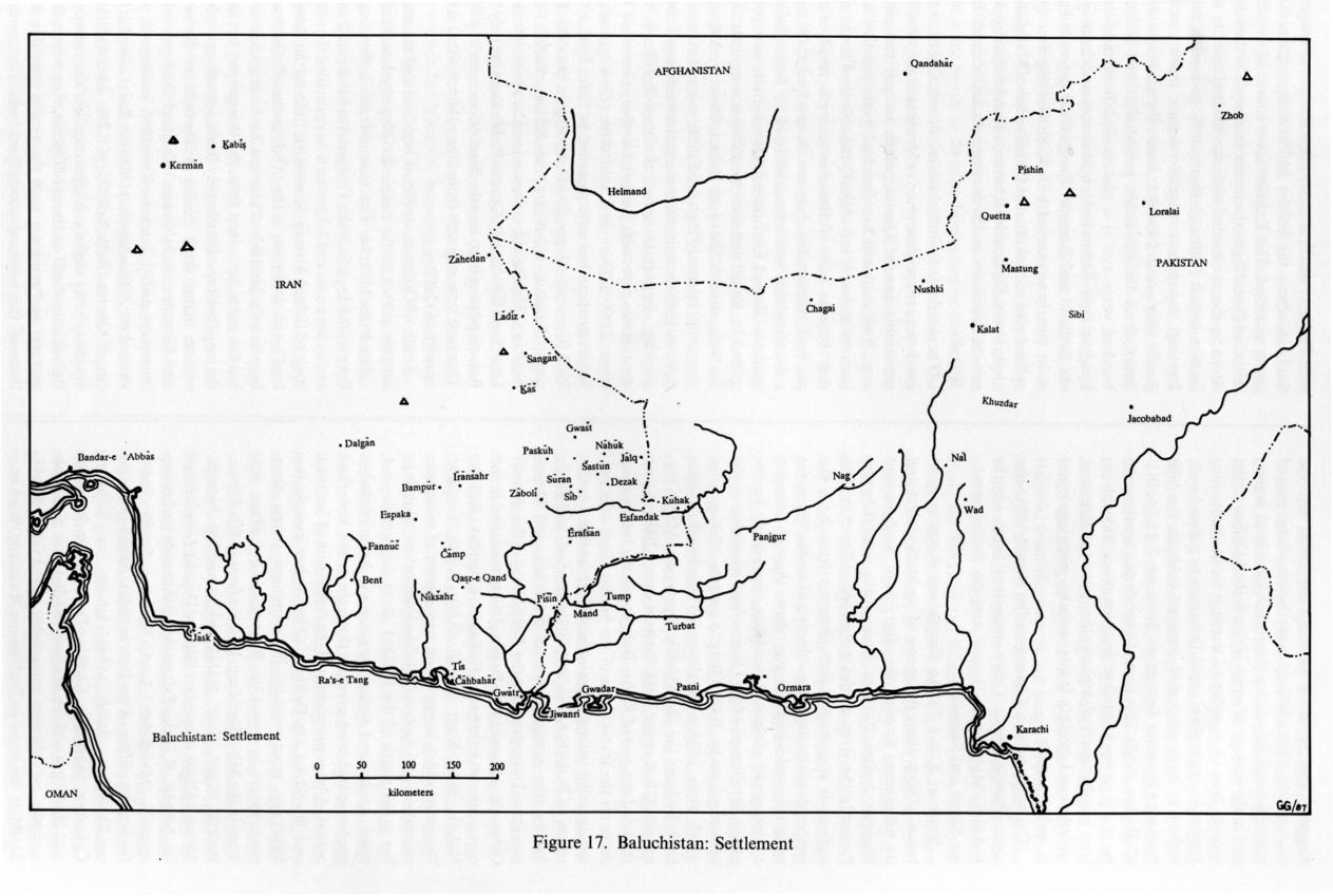
The total number of Baluch in Baluchistan (in Afghanistan, Iran, and Pakistan), the Arab states of the Persian Gulf, and elsewhere in Asia and Africa is variously estimated at between three and five million. Their history up to the time when they were drawn into Western colonial history in the 19th century is poorly known. A copious literature has been produced on them since then, especially in English, but also in Persian and several other European and regional languages. But so far there has been no attempt to synthesize and interpret all the available material (FIGURE 16, FIGURE 17).
Baluchistan is generally understood by the Baluch and their neighbors to comprise an area of over half a million square kilometers in the southeastern part of the Iranian plateau, south of the central deserts and the Helmand river, and in the arid coastal lowlands between the Iranian plateau and the Gulf of Oman. Its boundaries are vague and not consistent with modern provincial boundaries. It appears to have been divided throughout history between Iranian (highland) and Indian (lowland) spheres of influence, and since 1870 it has been formally divided among Afghanistan, Iran, and India (later Pakistan). It is unclear when the name Baluchistan came into general use. It may date only from the 12th/18th century when Naṣīr Khan I of Kalat during his long reign in the second half of the 12th/18th century became the first indigenous ruler to establish autonomous control over a large part of the area.
The origins of the Balōč and of their name are similarly unclear. They appear to have lived in the northwestern part of the area (southeast of Kermān) at the time of the Arab conquest. But their activities may even at that time have extended a considerable distance to the east. They appear to have migrated farther east, and beyond Makrān, beginning around the time of the arrival of the Saljuqs in Kermān in the 5th/11th century, and continuing intermittently for the next five centuries, up to the spread of Safavid power in the 10th/16th century, with major movements probably in the 6th/12th and 9th/15th centuries.
How and when the Balōč arrived in the region of Kermān is unknown. Their claim (in their epic poetry; see baluchistan iii) to be Arabs who migrated from Aleppo after fighting at Karbalāʾ cannot be taken at face value. The various inconclusive theories concerning their origins are reviewed by Dames (1904, pp. 7-16).
The scanty evidence for them between the Arab conquest and the arrival of the Saljuqs is also difficult to evaluate, partly because of the authors’ characteristic urban prejudice against nomadic tribes. But it suggests that they numbered in the tens of thousands at most; that they were pastoralists, herding sheep and goats; and that, like other Middle Eastern pastoralists, they were highly mobile, if not entirely nomadic, living in tribal communities (in the sense that they construed their social relations according to genealogical—patrilineal—criteria); and that they were poorly integrated into the settled polity, which they continually harassed.
In terms of general cultural values and world view, the Baluch in recent times resemble neighboring Muslim tribal populations in both the historical and the ethnographic records. What has emerged as distinctively Baluch, beside the language, Baluchi, is the structure of their social and political relations. But this structure is more likely to be a product of their recent pluralist experience in Baluchistan than a heritage of their earlier history. (It has not yet been changed significantly by their incorporation into modern state structures.) Baluch identity in Baluchistan has been closely tied to the use of the Baluchi language in intertribal relations. Modern Baluchi has a clear pedigree, with a number of grammatical features and vocabulary of the “Northwest” Iranian type (see baluchistan iii). But Baluch ethnicity today cannot be so clearly defined. On the one hand, many communities generally recognized as Baluch by themselves and by others are of alien origin and have been assimilated over the last four centuries. On the other hand, there is no evidence that all the considerable number of scattered communities known as Baluch in other parts of Iran, Afghanistan, and Soviet Turkmenistan (most of which are not presently Baluchi-speaking) are in fact historically related, or, if they are related, that they separated from each other in Baluchistan.
Within Baluchistan the population is not ethnically homogeneous. Some communities are identified (by themselves and others) as Balōč (see 10 below), with the implication that they are descended from those who entered the area as Balōč; while others, though considered members of Baluch society now and identifying as Baluch in relation to the outside world, are known within Baluch society by other tribal (e.g., Nowšērvānī, Gīčkī, Bārakzay) and subethnic (e.g., Brahui, Dehwār, ḡolām, Jaḍgāl, Mēd) designations, with the implication that they have adopted Baluch identity relatively recently—but not that they are for that reason in any way outsiders. Some of these “Baluch” predate the arrival of the Balōč. Others (e.g., the Bārakzay, q.v., who are of recent Afghan origin) postdate them. There are also remnants of what were (under autonomous Baluch rule, as well as under the British, 1666-1947) larger non-Muslim communities, mostly Hindu, Sikh, Ismaʿili, or Bahai traders, who are not considered Baluch. The Baluchi language was the language of interethnic as well as intertribal relations. Although participation in Baluchi intercourse generally seems to have led to assimilation, being Muslim appears to have been a necessary precondition. However, the Baluch in the Makrān who became Ḏekrī (Zikri) in the 10/16th century did not for that reason cease to be Baluch. The Baluch generally claim that all Baluch are Hanafite Muslims, although, apart from the Ḏekrīs (who are known but rarely discussed), there are some small Shiʿite communities on the northwestern fringes of Iranian Baluchistan, a fact which is unknown farther east.
The vast territory of greater Baluchistan has been divided historically into a number of areas, among which Makrān (in the south), Sarḥadd (in the northwest), and the area known earlier as Tūrān that includes the modern towns of Kalat and Khuzdar (Qoṣdār/Qozdār; in the east), have been the most significant. Stronger Iranian and Indian political centers to the west, north, and east (particularly, Kermān, Sīstān, Qandahār, Delhi, Karachi), and even the sultan of Oman to the south, have intermittently claimed suzerainty over parts of these areas, and considered them as their legitimate hinterland. The idea of one Baluch community in a politically unified Baluchistan may have originated in Naṣīr Khan’s successes in the 12th/18th century. His successors were unable to maintain control of the part of the area he claimed to rule as khan, let alone continue to pursue what appear to have been his ambitions to incorporate all the Baluch into one nation. But the policy of indirect rule pursued by the British, who began to encroach in the area during the following generation, and maintained the khan irrespective of internal processes that would either have destroyed or transformed the khanate, kept alive the idea of a unified Baluchistan—against considerable odds—at least up to the borders that the British negotiated with the Qajar government in Iran, and the Afghan government in Kabul in the second half of the 13th/19th century. By 1947, the idea of Baluchistan was too firmly established to be superseded or transcended by the new concept of Pakistan. The political activities of the Baluch in Pakistan (who constitute probably two thirds of the total Baluch population) reinforce and confirm Baluch identity in Iran, Afghanistan, and elsewhere.
The Balōč appear to have become culturally dominant in the area in the late medieval period, along with the spread of Baluchi as a lingua franca—though the details and causes of each process are unclear. It was not until much later that the majority of the population of the area came to identify themselves as Baluch, probably as a result partly of the success of Naṣīr Khan’s policies, and partly because of the later British administrative classification. The assimilation of almost the whole population to Baluch identity and the dominance of Baluchi (at least for public, political purposes) is difficult to explain, since the tribesmen who established the khanate of Kalat (and therefore also the political autonomy and identity of the area) in the mid-11th/17th century spoke not Baluchi, but Brahui, and conducted their administration in Persian by means of a bureaucracy recruited among the Dehwār, who were Tajik peasants. Immigrant Baluchi speakers (Balōč) were probably not numerically dominant except in non-agricultural parts of the area.
Baluchistan remains a palimpsest of cultural and linguistic discontinuities. Although the existing literature is much greater than for other comparable tribal areas of the Iranian world, the underlying heterogeneity raises a number of problems for any systematic account of Baluchistan and the Baluch. These problems cannot yet be definitively treated. Far more historical and ethnographic research is needed. What follows is only a preliminary synthesis.
2. Geography.
Baluchistan has received relatively little attention from geographers. Apart from the initial descriptions provided by scholars like Vredenberg for the Gazetteers, and by Harrison for the Admiralty Handbook (Persia), Snead worked along the Makrān coast in 1959-60, and Vita-Finzi worked in western Makrān in the mid-1970s—both geomorphologists—and Scholz, a cultural geographer, conducted short studies from Quetta. The standard work on the geography of Afghanistan (Humlum) devotes a few pages to the Baluch areas in the southwest of the country. The following description is based mainly on the Gazetteers and the author’s field notes.
Throughout most of Baluchistan the topography is extremely broken and mountainous, varying in altitude from 1,500-2,000 m (the steppe on the edge of the Iranian plateau, at the base of mountains) to over 3,500 m in the north and northeast and to sea level on the coastal plain. In the part that is now southwestern Afghanistan, and here and there in the 500 km-wide zone between the Afghan border with Pakistan and the coast, the land opens out into vast expanses of featureless semidesert and desert. Temperatures are continental in the highlands with bitterly cold winters and extreme diurnal and seasonal ranges; the lowlands and coastal areas are subtropical. Extremes of summer heat (with high humidity during the monsoon) occur at low altitudes away from the coast in the Kacchi-Sibi plain and the larger Makrān valleys. High winds are also regularly recorded, related to the well known bād-e sad o bīst rūz phenomenon in Sīstān.
Rainfall varies mainly according to altitude. Though rare in summer on the Iranian plateau, it may come at any season, but may fail altogether for several years in succession, especially at the lower altitudes. The highlands and high mountains in the east and northeast receive up to 400 mm, even more in places on the eastern escarpment. Most of the rest sees an average of 100 mm or less—though averages are misleading because of wide annual fluctuations. Rain falls mostly in winter (as snow at high altitudes). The monsoon brings summer humidity and occasionally significant rain to the coast and lowlands. For example, in 1964 it rained heavily every day for two weeks in August over a large area of Makrān (see below, on baš). Sometimes such weather edges up the escarpments and marginally affects the Iranian plateau. Summer rain can be torrential and in the mountains flash floods may cause sensational damage. Heavy rain turns the coastal plain into a morass of clayey mud, impassible for human, animal, or motorized traffic until it dries out, possibly as much as a week. In the southern mountains some rivers flow continuously for stretches; elsewhere occasional pools often last till the next flood. In the Nahang and Sarbāz rivers some of the deeper pools contain crocodiles. (Game generally has become scarce except for ibex in the higher mountains, and the ubiquitous partridge and smaller game birds, such as chikara, sisi, pigeon, and some sandgrouse and quail. Wild sheep, deer, black bear, wild pig, wolf, jackal, hyena, fox, and porcupine also occur.) Here and there pools provide a trickle of water to irrigate a nomad’s garden plot. Water is nowhere abundant or (with few exceptions) perennial, but in the mountains soil is the limiting factor for agriculture. On the coastal plain on the other hand, the soil is often good but there is no water except from rain or runoff, and the ports have no reliable water supply.
The history of settlement in Baluchistan is reflected in its toponymy. Place names fall into three categories: Names that are of Baluchi origin, or have been Baluchized, are used for most minor natural features: rivers, streams, rocks, mountains; old settlements and major natural features tend to have pre-Baluch names; and new settlements, dating from the middle of the last century in Iran, and the middle of this century in Pakistan generally have Persian or Urdu names. Urban settlement in Baluchistan today is all the result of Persian and Pakistani administrative and (more recently) development activity. The Baluch have never developed an urban way of life, and though many now live in towns, the towns are essentially non-Baluch (Iranian or Pakistani) in character. Most of the major Baluch agricultural settlements, however, have developed on the sites of pre-Baluch towns, known from the time of premedieval prosperity, that was based on investment in agriculture, as well as trade. Since the medieval period, both before and since the Baluch became dominant, up to the beginning of modern development, agricultural settlement has been dependent on the protection of rulers who lived in forts. A few traders clustered around the forts. But the cultural center of gravity of Baluch life was among the nomads who controlled the vast areas between the settlements.
Within the geographical and cultural diversity of Baluchistan a number of districts have emerged historically, each with its own distinctive geographical features. Starting from the Iranian plateau in the north, the following are the significant natural and cultural divisions of Baluchistan (the modern administrative divisions are almost identical): the Sarḥadd, the Māškīd (Maškēl) depression, the Māškīd drainage are of Sarāvān-Panjgur, the northeast highlands of Quetta, Pishin, Zhob, Loralai, and Sibi, the Mari-Bugti hills, the eastern highlands of Sarawan-Jahlawan, the Jāz Mūrīān depression, Makrān, the Kacchi-Sibi lowlands, and the coastal plain including Las Bela and Daštīārī.
“Sarḥadd” appears to have come into use in the medieval period for the southern “borderlands” of Sīstān. It is a high plateau, averaging 1,500-2,000 m in altitude and dominated by the two volcano massifs, Kūh-e Taftān (4,042 m) and Kūh-e Bazmān (3,489 m). Although it is now thought of as coterminous with the šahrestān of Zāhedān, its historical boundaries were not strictly defined and usage of the term varied according to fluctuation in the relative strength of local rulers: It was sometimes considered to extend into the northeastern part of the Jāz Mūrīān depression and into the Māškīd drainage of Sarāvān, and westward through southern Nēmrōz and Helmand provinces and Chagai and even into Kharan. It is characterized by cold winters and moderate summers, with precipitation concentrated in the winters, as snow on the higher ground. There are large areas of sand on either side of the border with Afghanistan. Apart from the general steppe vegetation, there are relict stands of wild almond and pistachio on the plains, especially between Ḵāš (also Ḵᵛāš, Bal. Vāšt) and Gošt (Gwašt), and juniper in the mountains. The area is characterized by isolated hills and depressions that function as internal drainage basins. The larger depressions, hāmūn, are generally saline; the smaller ones, navār, in some cases contain sweet water. Traces of old bands (q.v.) are evident on the plain southwest of Taftān and elsewhere. The only significant agricultural settlement of any antiquity is Ḵāš, which lies to the south of Taftān. A few old villages nestle at the foot of the mountain, mainly on the eastern side. The most notable are Lādīz and Sangān. Ḵāš depends upon irrigation from qanāts, which though probably ancient were redeveloped by entrepreneurs from Yazd under Reżā Shah. There are also a few qanāts across the border in Chagai.
Since the medieval period the Sarḥadd has been divided among a number of tribes. The most important are the Esmāʿīlzay (renamed Šahbaḵš under Reżā Shah), Mīr-Balūčzay, Rīgī, Yār-Moḥammadzay (renamed Šāhnavāzī under Reżā Shah), Gamšādzay, Nārūʾī, and Gūrgēč. Across the modern borders in Afghanistan and Pakistan the major tribes are Sanjarānī, Jamāl-al-Dīnī, Bādīnī, Moḥammad-Ḥasanī, and the Brahui-speaking Mengal. Some ten thousand out of the estimated ninety thousand Baluch in Afghanistan, especially the Nārūʾī, Rīgī, Sanjarānī, and Gūrgēč tribes, are closely related to the groups across the border in Iran and Pakistan. Most Afghan Baluch are presently refugees in the neighboring part of Pakistan.
The hāmūn of the Māškīd river lies on the southwestern side of a large depression of some 15,000 square miles that, although geographically an extension of the Sarḥadd, has generally been controlled separately from a fort on its northeastern side, known as Kharan. In the British period Kharan was a separate principality under Kalat. Earlier it had been dependent on Qandahār. It is mostly desert and includes a large area of sand dunes on the southern side. It is bounded on the north by the range of Raʾskoh which divides it from Chagai, and on the south by the Siahan range which separates it from Panjgur and Makrān. There is a large area of thick tamarisk forest downstream from the seat of the principality (Kharan-Kalat) on a river that was once dammed and supports annual cultivation. On the western side of the Māškīd hāmūn there is a large area of rather poor quality date palms which have been important in the ecology of some of the Sarḥadd tribes to the west in Iran. A number of massive stone dams, now known in the archeological literature as gabar-bands, appear to have supported terraced fields in the hills bordering the main depression (Stein, pp. 7, 15-34, 145-47; Raikes, 1965). This type of engineering continues to be practiced on a small scale throughout Baluchistan (and in other parts of Afghanistan, Iran, and Pakistan; see below and ābyārī). It was probably more important in earlier periods.
The ruling tribe in Kharan are the Nowšērvānī, who claim Persian origin. Other important tribes are the Raḵšānī, Moḥammad-Ḥasanī, and the Brahui-speaking Sāsolī and Samalārī.
South of Kūh-e Taftān the plateau drops away to below 1,000 m along the course of the Māškīd river and its tributaries, forming the districts of Sarāvān and Panjgur, before it turns back north into Kharan. Presently the river carries water only after rain. The ecology is transitional with elements from both the temperate plateau and the subtropical south. Where the main tributaries join, the river flows through a deeply eroded gravel plain and peneplain, completely barren except for clumps of pīš (Nanorrhops ritchiana) in the occasional wadis. Kūh-e Berg, a narrow 2,500 m ridge which runs 150 km northwest to southeast, divides Sarāvān from the Jāz Mūrīān depression. Magas (renamed Zābolī under Reżā Shah) at over 1,200 m below the southern end of Kūh-e Berg grows the best quality dates on the Iranian side of the border. East of it two long parallel valleys contain the old agricultural settlements of Paskūh, Sūrān and Sīb in the first, and Gošt, Šastūn (the modern town of Sarāvān), and Dezak (renamed Dāvarpanāh under Reżā Shah) in the second. Other old settlements lie farther downstream and in the mountains on either side: Kallagān, Esfandak, Kūhak, Nāhūk, Jālq, Kant, Hīdūč, Āšār, Afšān, Ērafšān. Bampošt, which is one of the major areas of mountain nomadism and āp-band (āb-band; see below) farming, lies to the south of the Māškīd. Both districts depend upon qanāts and settled populations have probably predominated over nomads throughout the historical period. A large proportion of the cultivators of Sarāvān and Sīb-Sūrān are Dehwār. Other tribes include the Bārakzay, most recently the dominant group, their predecessors in power the Bozorgzāda (of whom one branch, the Mīr-Morādzay, held the forts in Sīb, Sūrān, Paskūh, Kant, Gašt, Hūšak; while another branch, Neʿmat-Allāhī, controlled Jālq and Dezak), Nowšērvānī (in Nāhūk, Kūhak, Esfandak), Ṣāḥebzāda (who are sayyeds), Malekzāda, Lorī, Nātūzay, Sepāhī (who formed the militia of the Bozorgzāda), Arbāb (who are smallholders), Balōč tribes known as Sīāhbor, Čākarbor, ʿAbdolzay, Čārīzay, Dorrazay (in Bampošt and Hīdūč), Kord (in Magas); the Balōč in Salāhkoh and the neighboring mountains are Āskānī, Porkī, Sēpādak; the šahrī in Ērafšān are Raʾīs and Watkār.
In Panjgur, which in many ways is a mirror image of Sarāvān across the border in Pakistan, settlement is more restricted. The Raḵšān has a course of over 150 miles but from Nāg at the northeastern end of the valley down to the confluence with the Māškīd close to the Iranian border (although there are large areas of flood farming) it supports irrigation (either directly or by qanāt) only around Panjgur itself. Remains of a dam dating from the pre-Balōč period were still visible a hundred years ago at a place called Bonestān below Panjgur. Sarāvān has been most closely associated with the Sarḥadd and Bampūr. Panjgur has generally been most closely associated with Kech and therefore considered part of Makrān, but the influence of Makrān has always been disputed by Kharan, which has managed to remain dominant in the border area in Esfandak and Kūhak.
The districts of Zhob, Loralai, Pishin, Quetta in the northeast are based on river valleys that drain out of the mountains around Quetta, which include two peaks over 3,400 m. Until two hundred years ago they had been more closely related to Qandahār than Kalat, and they became part of Baluchistan as a result of the political relationship between Kalat and Qandahār, a situation that was later reinforced by British border interests. Except for Loralai these districts were never settled by Balōč and their population remains mainly Pashtun, unassimilated to Baluch identity. Although they enjoy relatively high rainfall they remained mainly pastoral until the recent commercial development of fruit growing. Important areas of forest survive in the mountains, especially juniper (Juniperus excelsus) between 2,000-3,000 m and wild olive (Olea cuspidata). Major earthquakes were recorded in 1888, 1892, 1900, 1902 (Gazetteer V, pp. 30-31), and again the 1936. The major Pashtun tribes are the Kākaṛ, Tarīn, Panī, Acakzay. The Baluch tribes in Loralai are the Buzdār, Lēgarī and Ḡōṛčānī. In Quetta-Pishin there are only few Baluch pastoralists, mostly Rind (Gazetteer V, p. 77). There are now migrants from many Baluch tribes in the vicinity of Quetta.
South of Quetta a tongue of highland and mountain extends almost to the coast, dividing the lower Indus valley from Makrān. The main rivers are the Hingol, Porali, Baddo, and Hab. This was the medieval Tūrān, and as Sarawan and Jahlawan it has provided the center stage of Baluch history. Sarawan is literally the “above-land” and Jahlawan is the “(be)low-land” (Jahlawan becomes Jhalawan in Pakistani Urdu nomenclature), but the terms derive not from the topography but from the two divisions of the largely Brahui-speaking confederation living there. Kalat is the seat of Sarawan and Khuzdar of Jahlawan. Nal and Wad are other important tribal centers. The 1936 earthquake destroyed the Aḥmadzay fort (Mīrī) in Kalat as well as the city of Quetta (Baluch, 1975, p. 121). Although these districts have slightly higher rainfall than most of Baluchistan south and west of Quetta, they were mainly pastoral and nomadic until the recent extension into them of the national power grid, which encouraged investment in wells and pumps and settled agriculture and led to neglect of the traditional qanāt and band technology (see below). Pastoral transhumance to the lowlands of Kacchi on the west, which was the basis of the political preeminence of the area, remains important. The major tribes are the Raʾīsānī, Šahvānī, Bangalzay, Lēhrī, Langaw, Rostamzay, Mengal, Bīzenjō, Kambarānī (Qambarānī), Mīrwarī, Gorgnārī, Ničatī, Sāsolī, Ḵedrānī, Zārakzay, and the Zēhrī (of which only the last is Baluchi-speaking).
East of Sarawan and Jahlawan the terrain drops almost to sea level within some 20 km. This is the piedmont plain of Kacchi (the northern part of it belongs to the district of Sibi that extends up the valleys into the high mountains east of Quetta). Kacchi is about 2,000 km2, sloping from an elevation of about 150 m at Sibi in the north to 50 m at Jacobabad in the south. Since the introduction of a canal from the Indus in the 1930s the southern part has become the most productive agricultural part of Baluchistan. The majority of the year-round population are Jats. Cultivation in Kacchi depends on harnessing the floods that arrive in July and August from the monsoon on the hills—there is less than 100 mm of rain on the plain. The main rivers are the Bolan and the Nari. Seasonal river discharge onto the agricultural land of Sibi, Kacchi, Las Bela, Bāhū, and Bampūr was traditionally managed in the same way (though on a smaller scale than) the discharge of the Helmand into the delta lands of Sīstān. (The annual rebuilding of the barrages in Sīstān is described in Tate, 1909, pp. 224-226.) It was the most important event of the year, using all available labor. Crops include sorghum, pulses, and sesame. There is a nāʾeb for each village, appointed by the khan. The Jats construct huge embankments across the dry riverbeds to catch and divert the torrential floods. As the fields are flooded, they break one dam and let the water rush down to the next. The Nari has more than fifteen such dams. Most of them require repair or reconstruction during winter, for which the labor is provided by the nomads. Nomads also provide the labor for harvesting. The traditional organization has been modified recently by administrative changes (N. Swidler, p. 102). The major tribes are the Rind, Magasī, Dumbkī, Omrānī, Bulēdī, Ḵōsa, Jātōī, Kēbārī, Mugārī, Dīnārī, Čālgrī, Marī, and Būgṭī.
South of Loralai an isolated area of hill country extends southward to the banks of the Indus, bounded on the east by the southern end of the Sulaiman range. These are the Mari-Bugti hills, called after the tribes that have controlled them with a considerable degree of autonomy into the modern period. They consist chiefly of narrow parallel ridges of closely packed hills, which form the gradual descent from the Sulaiman plateau into the plains, intersected by numerous ravines and generally barren and inhospitable. But here and there are good patches of grazing, and a few valleys which have been brought under cultivation. The Marī are the largest Baluch tribe and were estimated at 60,000 (Pehrson, p. 2). They are Baluchi-speaking and identify strongly as Baluch, claiming to be descended from a branch of the Rind tribe. But they speak a distinct dialect of Baluchi, and have always jealously guarded their autonomy from the larger Baluch polity, especially as represented by Kalat. In their political organization they display features that are reminiscent of their Pashtun neighbors, such as tribal councils.
To the northwest the historical boundary between Baluchistan and Kermān is a vague no-man’s land in the Jāz Mūrīān depression. The Jāz Mūrīān is a large hāmūn, about 300 km long and 70,000 km2 in area, into which the Bampūr river drains from the east and the Halīlrūd from the west. A low range separates it from Narmāšīr and the Dašt-e Lūt to the north. A large area of dunes impedes communication on the southeast side, and there is a thickly wooded area, mainly tamarisk, along the banks of the Bampūr river below Bampūr. Most of the rest, except for a varying amount of shallow water in the center, is flat desert, with high summer temperatures, but an open gateway to Kermān in the winter. There is a score of rich agricultural villages around Īrānšahr (previously Fahraj, Baluchi Pahra) and Bampūr (of which the largest is Aptar) depending partly on qanāts and partly on a dam above Bampūr, which is the site of the largest fort in western Baluchistan. The agricultural population is mainly low-status tribesmen and gōlāms. 100 km west of Bampūr, on the northeast edge of the central depression, is the center of the Bāmerī tribe, who breed the best fast riding camels. They engage in a small amount of cultivation based on shallow wells from which they raise the water by means of long counterbalanced poles (Arabic šādūf).
South of the Jāz Mūrīān and Sarāvān the Makrān mountains extend in a 150-220 km wide zone from Bašākerd in the west to Mashkai in Jahlawan in the east. There is a number of parallel east-west ranges and valleys that resemble steps from the Iranian plateau down to the coast. They are rugged and difficult to traverse, though the peaks rarely exceed 2,000 m. The most important rivers are the Jāgīn, Gabrīg, Sadēč, Rāpč, Sarbāz, Kech, and its tributary Nahang. The western rivers cut through the mountains in deep gorges, of which Sarbāz is the most spectacular. In the east the major river is the Kech, which runs 150 km due west between two ranges before joining the Nahang and turning south through a gap to the sea. Rainfall is scanty and irregular, and summer temperatures are high, but the monsoon brings humidity and occasional rain that reduces the temperature and resuscitates the vegetation. The Makrān mountains are the home of Balōč nomadic pastoralists. Natural vegetation is sparse, and they divide their time between their animals (mainly goats) and their āp-band. Where valleys open out and contain soil but no water, a band is built round a terrace of good alluvial soil to catch occasional rain, or water channeled from the river after flood. The few permanent settlements are riverine and small. Most are situated in the sweep of a bend or where a river issues onto desert plains. The main centers are Bent, Fannūj, Geh (renamed Nīkšahr under Reżā Shah), Qaṣr-e Qand, Bog, Rāsk, Čāmp, and Lāšār, Espaka, Mand, and Tump. There are over 50 villages on either side of a long gorge in the Sarbāz river, and an almost continuous string of oases lining the banks of the Kech river with fields and date plantations irrigated from both kārīz and cuts (Bal. kawr-jō; kawr is Baluchi for “river”) taking off from large pools in the river bed. Tump and Mand enjoy similar conditions. Kolwa is an 80-mile natural continuation of the Kech valley to the east separated by an almost imperceptible watershed. It contains by far the greatest dry crop area of the Makrān. The Dasht valley carries the united Kech-Nahang through the coastal range to the sea, irrigating important agricultural land on either side. The Buleda valley north of Turbat has some agriculture, as do some spring-irrigated areas in the Zamuran hills north of the Nahang river. Otherwise, apart from Parom and Balgattar which are saline flats, Makrān supports only pastoralism. The crops in the mountains are rice and dates, though a wide range of fruits and vegetables are grown in small quantities, and mangoes deserve special mention. Dates are par excellence the crop of the Makrān; 109 cultivated (nasabī) varieties are listed in the Makrān Gazetteer, apart from wild (kurōč) varieties. Pīš is the most typical of all Makrān plants. It grows on rocky ground up to 1,000 m, and provides a famine food, as well as fiber. The main tribes of the Makrān mountains are the Gīčkī, Bulēdī, Hōt, Bīzenjō, Nowšērvānī, Mīrwārī, Rind, Raʾīs, Lāndī, Kattawār, Kēnagīzay, Mullāzay, Šīrānī, Mubārakī, Lāšārī, Āhurānī, Jaḍgāl, Sardārzay. The Šīrānī hold Geh, Fannūj, and Bent; the Mubārakī, who are a branch of the Šīrānī, hold Čāmp and Lāšār. The Bulēdī held forts in Rāsk, Qaṣr-e Qand, Bog, and Hīt and their warrior zāt was the Bar. Katrī and Bāpārī are non-Baluch merchants. The cultivators in Makrān are mostly landless.
The coastal plain varies in width from almost zero to as much as 100 km in Daštīārī and more in Las Bela. It contains no reliable supplies of fresh water, but supports considerable forest and woodland of Prosopis, Zyziphus, and Acacia spp. The coastline is deeply indented with bays, which provide good anchorages for Čāhbahār (formerly Tīs, a little to the north of it) and Gwadar, among other ports. In the west the plain is mostly low and swampy or sandy, but farther east there are hills near the coast and headlands. Bare sandstone has weathered into fantastic shapes. At their seaward base some of them have deteriorated into badlands and are difficult to traverse. The main rivers, which only flow after heavy rain, pass between the sandstone massifs, providing the only passages inland. A line of mud volcanoes extends along the coast, of which the largest, Napag (10 miles north of Ras Tank/Raʾs Tang), has a cone built up to 50 m by constant eruptions of greenish mud (Persia, p. 141). There are extensive mangrove swamps intersected by creeks in the Gwatar bay and the rivers to the west. The rivers contain quicksands. The soil in Daštīārī and Bela, like Kacchi and some parts of Makrān such as Parom and along the Dasht river, has unusual moisture-retaining capability. After one good rain it will hold water long enough to obtain a crop of sorghum. Daštīārī relied on the Kājūkawr and Bāhū on the Mazankawr (the continuation of the Sarbāz river) for irrigation. But about a hundred years ago both of these rivers cut back so that except in exceptional floods the water was out of reach of the agricultural land. In both Daštīārī and Las Bela dams were built seasonally from earth and trees, as in Kacchi. Small fishing communities of Mēd live here and there on the beach. Scattered along the plain are mobile villages and camps of Balōč who are mainly pastoral, but practice a little cultivation after rain. All these populations have traditionally depended on rain and rain-filled ponds as the only source of water.
3. The origins of the Baluch.
The earliest extant source (Šahristānīhā ī Ērān-šahr, a Pahlavi text written in the 2nd/8th century, though probably representing a pre-Islamic compilation; see Markwart, Provincial Capitals, pp. 5, 15, 74-76) lists the Balōč as one of seven autonomous mountain communities (kōfyār). Arabic writers in the 3rd/9th and 4th/10th centuries (especially Ebn Ḵordāḏbeh, Masʿūdī, Eṣṭaḵrī, Moqaddasī) mention them, usually as Balūṣ, in association with other tribal populations in the area between Kermān, Khorasan, Sīstān, and Makrān. All these tribes (of which only the Balōč survive in name) were feared by the settled population. The sources also add some detail, but the implications are unclear. The Balōč appear to have had a separate district of Kermān, but they also lived in two districts of Sīstān (Eṣṭaḵrī) and appeared in a tract some distance to the east of Fahraj (the eastern border of Kermān), probably modern Kharan (Ḵārān) or Chagai (Ebn Ḵordāḏbeh). Eṣṭaḵrī also records them as peaceful, though Moqaddasī claims they were more troublesome than the Kūč, with whom they are often paired (for references see Dames, 1904b, pp. 26-33, who also provides a more detailed discussion).
The Balōč are generally considered to have arrived in Kermān from the north (e.g., Dames, 1904b, pp. 29-30). The evidence for this assumption depends on two arguments: the classification of Baluchi as a “Northwest Iranian” language and the fact that in Ferdowsī’s Šāh-nāma (composed at the beginning of the 4th/10th century on the basis of earlier works now lost) they are mentioned in conjunction with Gīlān. According to Ferdowsī (see, e.g., Dehḵodā, s.v. Balōč) the Sasanian kings Ardašīr and Ḵosrow I Anōšīravān fought the Balōč and the Balōč fought for several other Sasanian kings. It has also been argued that the Balōč left traces of their language in the oases of the central deserts of the Iranian plateau as they migrated south (Minorsky, 1957; Frye, 1961). Some of this evidence (e.g., place names), if pertinent, could be the result of later raiding activities on the part of small numbers of Baluchi-speakers. (Such activities have been recorded as late as the 13th/19th and early 14th/20th centuries.) There is no other evidence that could be used either to date or to corroborate the theory of a southward migration by the Balōč.
It is clear that the desert areas east and southeast of Kermān have been generally insecure throughout much of the historical period. The early Muslim writers were preoccupied with the unpredictability of populations not controlled by the government, and by the danger to travelers. Their descriptions tell us little more about the populations of these areas than we might expect. They kept flocks and lived in goat-hair tents. Their native language was not Persian. They seem to have been concentrated in the more fertile mountains southeast of Kermān and to have plundered intermittently on the desert routes to the north and northeast.
The situation with regard to the security of travel apparently deteriorated, because in 361/971-72 the Buyid ʿAżod-al-Dawla (q.v.) considered it worthwhile to conduct a campaign against them. The Balōč were defeated, but they continued to be troublesome under the Ghaznavids and the Saljuqs. When they robbed Maḥmūd’s ambassador in the desert north of Kermān between Ṭabas and Ḵabīṣ, Maḥmūd sent his son, Masʿūd, against them (Dames, 1904b, pp. 32-33). Although the eastward migration of the Balōč appears to have intensified soon after this, there are still Balōč in eastern Kermān province.
It is important to note that the sources do not mention any leaders. It is likely that the Balōč at this period were a series of tribal communities not sharing any feelings of common ethnicity. In fact, the name Balōč (Balūč) appears to have been a name used by the settled (and especially the urban) population for a number of outlaw tribal groups over a very large area. The etymology is unclear, as is that of Kūč (also written as Kūfeč, Kōfč or—arabized—Qofṣ), a name generally taken to refer to a comparable neighboring tribal community in the early Islamic period. The common pairing of Kūč with Balūč in Ferdowsī (see, e.g., Dehḵodā, s.vv.) suggests a kind of rhyming combination or even duplication, such as is common in Persian and historically related languages (cf. tār o mār). The Balōč may have entered the historical record as the settled writers’ generic nomads. Because of the significance of their activities at this period they would gradually have become recognized as the nomads par excellence in this particular part of the Islamic world. It is possible, for example, that Balūč, along with Kūč, were terms applied to particular populations which were beyond the control of settled governments; that these populations came to accept the appellation and to see themselves in the cultural terms of the larger, more organized society that was established in the major agricultural territories; but they remained, then as now, a congeries of tribal communities of various origins. There is also ethnographic evidence to suggest that Balūč, irrespective of its etymology, may be applied to nomadic groups by the settled population as a generic appellation in other parts of eastern and southern Iran. The other tribal populations recorded in southeastern Kermān in the early Islamic period, which did not survive in name, may have assimilated to the Baluch identity. An important feature of the history of the Baluch up to the 14th/20th century has been their ability to assimilate numerous and diverse elements. Their history may have begun in the area east and southeast of Kermān around the time of the Arab conquest and their ethnogenesis may have been a product of the insecurity of a vast desert area which the governments of the period did not care to control despite their need for secure communications across it. It must be remembered, however, that such a theory of the origin of the Baluch leaves open the question of how and when the language spread to become the lingua franca (though not the mother tongue) of all assimilated Baluch.
4. The early history of the area.
Throughout its history the area between Iran and India has been strongly affected by influences from the more fertile areas surrounding it, particularly Kermān, Sīstān, Qandahār, Punjab, Sind, and Oman. Sea traffic connected it to the Indian Ocean and the Persian Gulf. Little historical research has yet been focused on it, and the relevant syntheses so far available derive coincidentally from the pursuit of answers to questions arising from primary interests in the civilizations to the east and west.
What is now Baluchistan has long interested scholars as the hinterland of the settled societies of the Indus valley, the Iranian plateau, and Mesopotamia. A number of important archeological sites have yielded evidence of human occupation extending back to the fourth millennium (see baluchistan ii). Archeologists and philologists have sought evidence of overland connections between the early civilizations of the Indus valley and Mesopotamia. Between 3000 and 2000 b.c. Sumerian and Akkadian records indicate trade relations between the Tigris-Euphrates valley and places called Dilmun, Makan, and Melukhkha, which, though their exact location has been a matter for debate, were obviously situated down the Persian Gulf and beyond. Makan is generally assumed to be related to Makrān which in later historical periods is the name of the southern half of the area, the coast, and its hinterland (Eilers, Hansman). Whether or not Makan always included this area, in the early periods the name seems to have applied mainly to the southern shores of the Gulf of Oman. This connection is significant, since it has continued into the present (though in more recent times the close relationship between the populations of what are now Baluchistan and Oman has been reduced by the apparatus of modern nation-states).
From the mid-1st millennium onward the area was divided into named provinces of the Persian empires. Maka and Zranka appear in the inscriptions of Darius at Bīsotūn and Persepolis. Maka here is certainly modern Makrān (the southern half of Baluchistan), and Zranka (NPers. Zarang), the Zarangai of Herodotus, Drangiane of Arrian, etc., was Sīstān, which appears then and later to have included most of the northern parts of the area and sometimes even to have extended into Makrān. More specific information is provided by Greek authors who began to be interested in the Persian Gulf as a result of the Persian wars (Herodotus, 3.93). Alexander’s expeditions beyond the Persian empire late in the 4th century generated more detailed writing. This was further encouraged by commercial interest in the sources of various luxury commodities, mainly spices and dyestuffs, which were already reaching the eastern Mediterranean from the Indian Ocean.
The province Alexander traversed on his return to Iran from India was named Gedrosia. The experience of his army and fleet given by Arrian is interesting because it suggests that (contrary to the assessments of modern ecologists) the natural conditions of Baluchistan have not changed significantly over the past 2,300 years. There were ports in Sonmiani Bay, northwest of modern Karachi, and at Gwadar (Badara) and Tīs (Tesa; earlier Talmena). Population was generally sparse, partly Indian, including the Arbies and Oreitae, partly Iranian, including the Myci (assumed to be related to Maka). Water and provisions were difficult to find without good guides. In the inland valleys agriculture was facilitated by sophisticated engineering of small-scale irrigation, based mainly on the yield from summer rains. The most fertile area was the Kech valley, which was densely settled. A highway to the Indus ran from the capital Pura, probably modern Bampūr, which is the largest area of fertile watered land, though it could have been in Kech, the next largest, or possibly even in one of the narrower river valleys, such as the Sarbāz. Indians, both Hindu and Buddhist, lived in Pura; through it both land and sea trade could pass onto the arterial route to Kermān.
Alexander founded an Alexandria at the principal settlement of the Oreitae in modern Las Bela. As he proceeded westward he was forced to strike inland by the difficulty of the coastal terrain. Between Bela and Pasni was the worst stretch of the whole expedition. Apart from intolerable heat and lack of food, water, and firewood, at one point a flash flood swept away most of the women and children following the army and all the royal equipment and the surviving transport animals. From Pasni they proceeded along the flat coastal plain to Gwadar, then inland to Pura. The experience of the fleet under Nearchos was similar. The daily search for food and water rarely produced more than fish meal and dates, sometimes nothing. Along the beach they found communities of Ichthyophagi (fish eaters), hairy people with wooden spears who caught fish in the shallows with palm bark nets and ate them raw or dried them in the sun and ground them into meal, wore fish skins, and built huts of shells and bones of stranded whales (Arrian, Anabasis 21-26, Indica 23-33).
The next significant information comes from the Sasanian period, when the area was once again integrated into a provincial administration. A king of Makrān paid homage to Narseh (son of the Sasanian Šāpūr I) at Narseh’s accession, who during the reign of his father bore the honorific (?) title of “king of Sakastān, Tūristān, and Hind up to the shore of the sea,” and later Bahrām’s son is called King of Sakas in the Paikuli inscription, which suggests that it was a not insignificant province (Skjærvø, III/2, pp. 10-11). Šāpūr I named four administrative entities within the area—Tugrān (later Tūrān, and presently Sarawan or Kalat), Pāradān (probably modern Kharan), and Hind (presumably Sind, or the land watered by the Indus), as well as Makrān—as appendages of Sakastān (Sīstān). The eastern boundary of the Sasanian province of Kermān was set at the port of Tīs on the coast, and at *Pohlpahraj (Fahraj), modern Īrānšahr, just beyond Bampūr at the far side of the irrigable area of the Jāz Mūrīān depression. Beyond that the kingdom of Makrān stretched along the coast to the port of Daibul at the mouth of the Indus. The kingdom of Pāradān stretched eastward from Bampūr to Tūrān. The kingdom of Tugrān probably extended from Kīzkānān (modern Kalat) and the Bolan pass (that connected Walishtan, modern Quetta, with the Sibi and Kacchi lowlands) through the Budahah district and the Pab and Kirthar ranges to a vague border with Makrān and Hind near Daibul. It appears to have been well populated by people who spoke a non-Iranian language, possibly Brahui as today. The main town was called Bauterna (modern Khuzdar). (For references and more detailed discussion see Brunner, pp. 772-77; Chaumont, pp. 130-37.)
Toward the end of the caliphate of ʿOmar, Makrān was invaded by the Arabs (23/644), who found it as unattractive as most outsiders appear to have done both before and since. After defeating the local ruler and marching almost to the Indus, they reported back to ʿOmar that it was an unattractive region, with the result that ʿOmar ordered that the Arabs should not cross the Indus. A similar sentiment is attributed to another commander: that the water in Makrān was scanty, the dates poor in quality; that a small army would be swallowed up in the deserts and a large one would die of hunger (Bosworth, 1968, pp. 1-25).
After the Arab conquest most of the area soon returned to its more characteristic condition of internal autonomy under alien hegemony. In particular it continued to serve as a refuge for people who had been displaced from the more fertile conditions of Iran and India. Especially, in the next few centuries, since Sīstān was a major center of Kharijite sentiment, many Kharijites found their way into Makrān (Bosworth, 1968, pp. 37-41 ).
In the early 5th/11th century the Ghaznavid empire established a pattern which has continued into more recent history. The geopolitical interests of the Ghaznavids, centered to the northeast of the area, complemented the decline of Sīstān, and brought Qoṣdār (Khuzdar), and through it much of Makrān, into dependency on Qandahār. Since then, although the governments of the western plateau (modern Iran) continued (until the establishment of Zāhedān as the administrative capital of the Iranian province of Baluchistan under Reżā Shah) to see Makrān as an extension of Kermān, governments on the eastern plateau (modern Afghanistan) have seen it as a southward extension from Qandahār.
Over the next three centuries, when first the Saljuqs and then the Mongols ruled in Iran, Iranian influence did not extend very far beyond Kermān, and Makrān became relatively autonomous again. In the 7th/13th century Marco Polo calls it Kesmacoran (Kech-Makrān), suggesting that the agricultural settlements along the Kech river were the most flourishing part of the area. Food was abundant and good (he mentions the full range of staples: rice and wheat, meat and milk). Kech had its own ruler (malek), and the people, who included non-Muslims and lived by commerce as much as agriculture, trading both overland and by sea in all directions, spoke a language Polo did not recognize. It is also worth noting that he identified the kingdom of Kesmacoran as the last in India, rather than the first in Iran (II, pp. 401-03). During this period Balōč migration intensified and the area began to take on the character of Baluchistan, absorbing a succession of immigrant groups, of which the Balōč were neither the first nor the last. But the history of the area cannot be understood as a refuge area or backwater. It is a borderland between India and Iran and a bridge between the Iranian plateau and the Arabian peninsula. Political and economic influences from both Iran (including what later became Afghanistan) and India continually affected the political economy, and local leaders have generally looked in both directions for potential sources of external support in their internal conflicts.
5. The eastward migrations of the Balōč.
Although many Balōč moved into and through Makrān starting in the 5th/11th century, others were probably already present in the general area east of Kermān. Evidence for the migration is sparse. There are two major types: the corpus of traditional Baluchi poetry and later Mughal histories.
The poems claim that the Balōč are descended from Mīr Ḥamza (Mīr is a Baluchi title for leaders, Arabic amīr), the uncle of the Prophet; that they fought with the sons of ʿAlī at Karbalāʾ, whence they migrated to Baluchistan. There are two possible interpretations of this epic history. First, tribal populations in the Muslim world have typically traced their genealogies back to the time of the Prophet as a way of legitimizing their Islam in their own tribal (i.e., genealogical) terms. Second, there are a number of ways in which Arab groups could have found their way into the heterogeneous tribal population that eventually assimilated Baluch identity east of Kermān, whether or not their forebears had fought at Karbalāʾ. Some of the original Arab invaders may have remained in the area, and there is evidence of migration across the Persian Gulf from Arabia into the Kermān region in the early centuries of Islam.
The poems tell of arrival in Sīstān and of the hospitality of a king named Šams-al-Dīn. A ruler (malek) by that name claiming descent from the Saffarids is known to have died in 559/1164. After a time another ruler called Badr-al-Dīn (of whom we have no independent record, unless he was a Ghurid) persecuted them and drove them out. Little else of any significance is identifiable, except the occasional place name in Makrān (see discussion in Dames, 1904b, pp. 35-36). It seems likely that this sort of eastward progress was determined by the use that various minor rulers may have had for a mercenary force.
The first record of movement into Sind is from the 7-8th/13-14th centuries. The main divisions of the Balōč tribes described in the poems presumably reflect events during this period. According to the poems a Mīr Jalāl Khan who was leader of all the Balōč left four sons, Rind, Lāšār, Hōt, and Kōraī, and a daughter named Jātō, who married his nephew Morād. These five became the eponymous founders of the five main tribes of the poems, the Rind, Lāšārī, Hōt, Kōraī and Jātōī. The poems tell of forty-four tribes (called tuman or bōlak), of which forty were Balōč, and four were servile tribes dependent on them. Other important names that have survived to the present are Drīšak, Mazārī, Dumbkī, Khōsā. The Hōt seem to have been in the area earlier than the others. It may be significant that some names are derived from known place names in Baluchistan. Many of the prominent tribes of today are not mentioned in the poems, such as Būgṭī, Bulēdī, Buzdār, Kasrānī, Lēgarī, Lund, Marī. Since these tribes were probably there in the 9th/15th century, the absence of their names in the poems suggests that either they are later branches of the old tribes, or they were not then Balōč and have been assimilated since.
In the 9th/15th century another wave carried the Balōč into southern Punjab. This was the period of Mīr Čākar (Čākor) Rind, the greatest of Baluchistan heroes. Some groups from the Rind tribe migrated from Sibi to Punjab, and spread up the valleys of the Chenab, Ravi, and Satlej rivers. Meanwhile, the Dōdaī (probably a Sindhi tribe assimilated during the previous 200 years) and Hōt moved up the Indus and the Jhelam. Bābor, the first Mughal emperor, found Balōč in Punjab in 925/1519. He hired them, as did his successor, Homāyūn. The first actual settlement of Balōč in Punjab appears to have been made in the reign of Shah Ḥosayn in Multan 874-908/1469-70-1502, who gave them a jāgīr (probably in return for military service)—an act which attracted more Balōč into the area. In Punjab many Balōč turned to settled agriculture in the 10th/16th century. (The references for this period are listed and discussed in more detail by Dames, 1904b, pp. 34-43.)
Although large numbers of Balōč moved into the Indus valley, there has never been any question of moving the boundaries of Baluchistan eastward to incorporate them. Balōč who settled in the lowlands, with the exception of Kacchi, tended to assimilate linguistically with the surrounding population, and lose their ties with kin in the highlands, though many (we cannot know what proportion) have retained their Balōč identity.
6. Events leading to the establishment of the Baluch khanate of Kalat. The 10th/16th century saw the rise of Safavid power in Iran and of Mughal power in India, and the arrival of European ships in the Sea of Oman and the Persian Gulf. The interests and conflicts of these three outside powers could not fail to affect the internal politics of the Balōč and other communities that lay between them. The major events that form the basis of Baluchi epic poetry, remembered as the wars between the Rind and Lāšārī tribes, occurred during this period and were obviously conditioned by the opportunities and incentives afforded by the larger geopolitical context.
The Safavids reestablished some Iranian control in Makrān, mainly from Bampūr, Dezak, and Sīstān (Röhrborn, pp. 12, 74, 82-83). In 1515, Shah Esmāʿīl (who had no navy) was forced to accept the Portuguese occupation of Hormoz, and concluded a treaty with the admiral, Alfonso de Albuquerque (q.v.), on terms that included the provision that the Portuguese would assist the shah in suppressing a revolt in Makrān. However, this collaboration, which would have been the first of its type with a European force in the area, proved abortive because of Albuquerque’s death. In 1581, for reasons that are unclear, the Portuguese destroyed the ports of Gwadar and Tīs, (Lorimer, I/1A, pp. 7-8).
The Dutch arrived in Hormoz at the beginning of the 11th/17th century and the British appeared soon afterward. In 1613 Sir Robert Sherley, who stopped at Gwadar on his way to Isfahan as ambassador, was nearly killed when a group of Baluch made a surprise attack on his ship. But afterward he wrote to the East India Company (established in 1600) in London recommending that they set up a factory in Gwadar, because it was autonomous, tributary to Iran, safe from the Portuguese, and promised “the richest traffic in the world.” In 1650 a Baluch guard defended Muscat (Masqaṭ) on behalf of the Portuguese (though the Imam of Muscat ousted the Portuguese later in the same year; see Lorimer, I/1A, p. 39). All the Europeans readily took on various groups of Baluch as guards and mercenaries. The Baluch did not display any solidarity in relation to these non-Muslim aliens. Baluch and foreigner cooperated or fought, according to local interests and animosities.
At this time the overland traffic was still taxed by the ruler (malek) of Kech, who also controlled Gwadar, and according to Pietro della Valle was on friendly terms with the Persian government. But around 1029/1620 Kech was taken over by the Bulēdī tribe, who appear to have been followers of the Ḏekrī (Zikri) heresy (see 11 below: ethnography), and dominated the whole of Makrān up to Jāsk until 1740 (Lorimer, 1/2, pp. 2150-51).
The prevalence of heresy in Makrān during this period may have separated it more than usual from the events of the highlands. Qandahār and the Quetta-Pishin area to the north changed hands between the Safavids and Mughals more than once, but although the Safavids eventually retained Qandahār and claimed the highlands down to Kalat (Röhrborn, p. 13), the Mughal influence was more significant in the history of the Baluch. Homāyūn is reputed to have given Shal (Quetta) and Mastung to a Baluch named Lawang Khan (Gazetteer V, p. 34). A Mīr Qambarānī (Kambarānī) used Mughal support to drive out the Jats from the Jahlawan district to the south, though his son, Mīr ʿOmar, was confronted with the Arḡūns of Qandahār. When Bābor took Qandahār (1522), Shah Bēg Arḡūn had moved to Sind, and Mīr ʿOmar seized an opportunity to take Kalat. He was driven out and killed by Rind and Lāšārī Balōč from Makrān, who included the figures celebrated in the heroic ballads, Mīr Šayhak Rind, his son Mīr Čākar Rind, and Mīr Gwahrām Lāšārī. But the Baluch did not stay; they moved on to Kacchi, leaving Mīr Čākar’s father-in-law, Mīr Mandō, in Kalat. Mīr Čākar appears to have remained in the area of Sibi and the Bolan Pass. In 1556 shortly before he died he is said to have acknowledged the suzerainty of the Mughals. In Kalat Mandō was soon overpowered by Brahui tribesmen under Mīr Bijjar, the son of ʿOmar. After Mīr Bijjar, Kalat was again taken by the Mughals, though they never managed to control the surrounding tribes. But with the loss of Qandahār the Mughal hold on the highlands weakened and the Brahui under Mīr Ebrāhīm Khan Mīrwārī managed to regain Kalat. Mīr Ebrāhīm declined to rule, and the khanate was offered to Mīr Ḥasan, his brother-in-law. Mīr Ḥasan was the first “khan of the Balōč.” The term Baluch (as used in this article) applies to participants in the polity that developed under his rule and that of his successors.
Mīr Ḥasan died without issue shortly after acceding to the title, the government passed to Mīr Aḥmad Khan Qambarānī, who became the eponymous founder of the Aḥmadzay dynasty of the State of Kalat (Ratuch, pp. 69-75; Rooman, pp. 28-29).
7. The Aḥmadzay khanate of Kalat up to the intrusion of British power (1666-1839).
The major factors in the history of Kalat in this period (before the encroachment of the British and the reawakening of Persian interest in the area) were the expansion of Kalat territory under the early khans, the effects of Nāder Shah’s activities with regard to India, and the Persian Gulf; the power of Nāder Shah’s successor in Qandahār, Aḥmad Shah Abdālī; the decline of the khanate after the death of Mīr Naṣīr Khan I in 1795; the ambitions of Moḥammad Shah Qājār, and the development of British interest. The uplands and the lowlands continued to have distinct political histories, though the success of Naṣīr Khan I in the second half of the 12th/18th century integrated them to some extent for the duration of his reign. From this period onward the history of the area has been seen in relatively exclusive terms as the history of Baluchistan (though its exact boundaries were often vague). Outside interest in the area, such as that of Oman (in Gwadar) and of Afghanistan (in “Pashtunistan”), have been seen as intrusive. However, a deeper historical perspective makes it clear that up until this period the area was neither an exclusive nor an integrated political or cultural unit; rather it formed part of a larger area that included Qandahār and Sīstān to the north and Oman to the south, and lay between the political poles of Iran and India. Within Kalat the highlands and lowlands were only loosely related: The lowlands were closely related to Oman, and the highlands were an extension of Qandahār. The subsequent history of the area is easier to follow when seen in these larger geopolitical terms. (This section is based on the more detailed discussions in Baluch, Lockhart, Rooman, the Gazetteers, and the author’s unpublished ethnohistorical research.)
Continuity of authority in Kalat dates from the accession of Mīr Aḥmad Qambarānī in 1666. Mīr Aḥmad ruled for thirty years and became an ally of the Mughal emperor Awrangzēb ʿAlamgīr I. He spent his life fighting the Bārōzay Afghans to the north and the Kalhora rulers of Sind to the south in order to preserve and expand his territory. He finally succeeded in controlling both Sibi and the Quetta-Pishin area. But his son, Mīr Meḥrāb Khan I, was still obliged to fight the Kalhoras. He defeated them in 1695, though he died in the battle. Mīr Samandar Khan, Meḥrāb’s brother’s son and successor, continued to keep the Kalhora family in check and also defeated a military expedition from Iran under Ṭahmāsb Bēg, who planned to annex western Baluchistan to Iran. Samandar was rewarded for these services by the Mughals with the port of Karachi and other gifts.
The acquisition of power by a local leader, who was able to establish the framework for dynastic succession in Kalat, transformed the political economy of the area, and set the scene for the later development of Baluch society. During the two centuries up to the time when the British took over the affairs of Kalat the general pattern of the khan’s external relations was accommodation with the political power in Qandahār and in Delhi, hostilities with Sind, and disorder in relations with Kermān. Baluch tribes in western Makrān and the Sarḥadd often raided into Iran—especially during the reign of Shah Sultan Ḥosayn, the last Safavid monarch 1105-35/1694-1722 (Lorimer, I/2, p. 2152). In 1721 the British and Dutch factories at Bandar-e ʿAbbās (q.v.) were attacked by a force of four thousand Baluch on horseback, who (apparently encouraged by the Afghan invasion of Persia) overran the province of Kermān and raided westward into Lorestān.
The rise of the Ḡelzay under Mīr Ways in Qandahār early in the 12th/18th century changed the political climate in Baluchistan. Quetta and Pishin were reattached to Qandahār in 1709. Mīr Aḥmad Khan II, the son of Mīr Meḥrāb Khan, whose profligacy displeased the Baluch sardars, was killed by his younger brother Mīr ʿAbd-Allāh Khan who then succeeded him. ʿAbd-Allah (r. 1714-34), who was known as Qah(h)ār Khan, was one of the stronger Aḥmadzay rulers, and remained relatively free to pursue his military and political ambitions during the period immediately preceding Nāder Shah’s appearance at Qandahār. He managed to conquer Kacchi in the south, Harand and Dajil in the northeast, Panjgur, Kech, and even Bandar-e ʿAbbās to the west, and Shorawak in the northwest. The last brought him into more direct conflict with Shah Ḥosayn Ḵaljī (r. 1725-38) of Qandahār, who joined forces with the Kalhoras in Sind in an attempt to defeat him. They were successful, and the khan tried to punish the Kalhoras again, but was defeated and killed in Kacchi.
Though the Aḥmadzay’s alliance with the Mughals had served them well, their enforced accommodation with the highland power of Nāder Shah and his successor in Qandahār, Aḥmad Shah Abdālī, served them even better. The conflict between Nāder Shah and the Mughals allowed the Aḥmadzay to establish themselves to the point where the British would later decide to rule through them, despite their declining abilities.
In concentrating his attention on the south, Mīr ʿAbd-Allāh Khan had served the Mughals too well and incurred the wrath of Nāder Shah. Nāder had named ʿAbd-Allāh his governor of Baluchistan and required him to move against the ʿAbdālīs in Qandahār from the south, while he, Nāder, moved in from the west. Owing to his entanglement with the Kalhoras, which led to his death in battle, ʿAbd-Allāh had failed to respond. Before Nāder was able to punish Kalat, ʿAbd-Allāh’s son, Mīr Moḥabbat Khan, was found unsatisfactory by the Baluch sardars, and replaced by his brother Mīr Ahltāz Khan. However, the sardars soon found Mīr Ahltāz no better and reinstated Moḥabbat (though Ahltāz seems to have retained some power among the Dehwār in Mastung). Nāder sent Pīr Moḥammad, the beglarbegī of Herat, against Kalat. In 1149/1736, rather than fight, both Moḥabbat and Ahltāz went to Qandahār and submitted to Nāder Shah, who took the elder, Moḥabbat, into his service and appointed him governor of Baluchistan including Makrān. Nāder also gave them the lowland plains of Kacchi (then ruled by the Kalhoras of Sind) as blood compensation for the death of Mīr ʿAbd-Allāh Khan. As a result the khanate now controlled both highland and lowland grazing and more land for cultivation throughout the year. Their resource base was greatly increased and the stage was set for further internal political development.
Following the assassination of Nāder Shah in 1160/1747, Aḥmad Shah Abdālī, later known as Dorrānī, who was heir to Nāder Shah’s paramountcy over Kalat, deposed Moḥabbat and put in his place another younger brother, Mīr Naṣīr Khan, who with his mother had been a hostage in Nāder’s camp since 1737. Naṣīr was historically the most significant of the Aḥmadzay rulers. He ruled for nearly half a century, and established the organization of the state of Kalat for the remainder of its existence. He was the only khan who successfully transcended tribal loyalties.
Of the land that had accrued to the state of Kalat up to this time half was reserved for the Aḥmadzay as crown land and the other half was divided among the tribes that made up the fighting force from Sarawan and Jahlawan. The khan allocated land to the tribes in two categories: gām lands and jāgīr lands. Gām lands were allocated according to the number of fighting men supplied by each tribe, with the stipulation that the land be used to raise crops to support the fighting force in the field. Since it was communal property of each tribe, it could not be alienated. One-twelfth of the income was gathered by the leader of each tribe and submitted to the khan as revenue. Unlike the jāgīr this land could be confiscated by the khan if the tribe failed in its obligations. It is interesting to note that this communal tenure originated with the khan and was not generated by the tribal community itself, as is often assumed. The khan’s crown lands were worked by Dehwār, whereas the tribes used Jat cultivators.
Naṣīr set about building his fighting force in three “regiments”: the Sarawan regiment, the Jahlawan regiment, and a special regiment directly under his own command. He chose one tribe each from Sarawan and Jahlawan (which may have laid the basis of the later ranking of the tribes) to lead and to be responsible for recruitment from their respective areas. He also formed a bureaucracy, by creating offices of government: a wazīr was given charge of internal and foreign affairs; a wakīl was made responsible for the collection of tribute and blood compensation, and the revenue from crown lands; a dārōḡa was put in charge of the organization of the Dehwar cultivators on crown lands, and worked through Brahui nāʾebs (deputies). Finally, a šāh(ā)qāsī (after Nāder’s ešīk-āqāsī was given direction of darbārs and the seating arrangement for leaders according to their rank. Beside these officers, he created two councils. Membership in one of the councils (majles-e moṣāḥebīn) was by his own nomination, and primarily from among his close kinsmen, but it also included the two leaders of the tribes of Sarawan and Jahlawan. The second was a council of sardars (majles-e mošāwarat). Members of the first council, or their representatives, had to remain at Kalat continuously along with one-twelfth the number of soldiers raised by each tribe (gāmē paškar). Judicial powers were vested in the sardars who were subject to guidance by qāżīs (judges) according to the religious law (Šarīʿa), except that local custom took precedence in matters of adultery and murder. The written language for state business was Persian, and bureaucratic positions were recruited from the Persian-speaking Dehwār peasant community.
Quetta had come under Nāder Shah when he took Qandahār, and he assigned it to Naṣīr and his mother during the time that Mīr Moḥabbat Khan held Kalat. Aḥmad Shah is said to have finally given it to Kalat after receiving assistance from Naṣīr in a campaign in eastern Iran in 1751—as a kind of šāl (lit. present of a shawl) for his mother, Bībī Maryam. But Pishin remained under the Dorrānīs.
Kalat was still subordinate to the Abdālī court of Qandahār. The treaty between them called for an annual payment of Rs 2,000 from Kalat to Qandahār, and the provision and maintenance of 1,000 soldiers in Qandahār. An apparent act of insubordination on the part of Naṣīr, who failed to respond when summoned to Qandahār, led to the negotiation of a new treaty after Aḥmad Shah Abdālī failed to defeat him outright.
Because Aḥmad Shah needed Naṣīr’s support elsewhere, the new treaty was more equal. The khanate no longer paid tribute or maintained a force at Qandahār. Instead, Kalat provided a fighting force only when the Afghans fought outside their kingdom, and then the khan would be provided with money and ammunition. The new treaty was sealed by a pledge of loyalty to Qandahār and the marriage of the khan’s niece to Aḥmad Shah Abdālī’s son. In the settlement with Qandahār the final accommodation was that the shah gave Naṣīr the title of beglarbegī while the khan recognized him as suzerain.
With the security and freedom of action afforded by the new treaty with Qandahār and the resulting stabilization of the northern and eastern border, Naṣīr was able to move against the neighboring territories of Kharan, Makrān, and Las Bela. The Gīčkī (who had become dominant in Makrān in 1740) and most of the Bulēdī were Ḏekrī. Naṣīr made nine expeditions against them. The struggle was ended, apparently before 1778, by a compromise under which the revenues of the country were divided equally between the Gīčkī leaders and the khan, with the direct administration remaining in the hands of the Gīčkī, who were divided into two branches, a senior branch in Panjgur and a junior one in Kech and Gwadar.
Naṣīr led some twenty-five military expeditions during his rule. Beside the Gīčkī in Makrān, he fought against Las Bela, Kharan, the Marī, and the Baluch Tālpūr family that had succeeded the Kalhoras in Sind. All these accepted his suzerainty. He also fought with the Sikhs of Punjab and with ʿAlī Mardān Khan of Tūn and Ṭabas in eastern Iran. At the end of his rule his authority extended over an area not very different from the later Pakistani province of Baluchistan, though it did not extend so far to the north or northeast, and only the central parts were directly administered.
Meanwhile, the course of events in the Makrān lowlands had been changed by activities in Oman and by the interest Nāder Shah had taken in the Persian Gulf—although Nāder’s officers were incompetent and corrupt and were defeated by the Gīčkī. The imam of Oman continued a practice, possibly originated by the Portuguese, of recruiting Baluch from Makrān into his service. At least one exclusively Baluch community on the Omani coast today dates from this period. In 1740 Aḥmad b. Saʿīd, governor of Sohar, conducted a coup and founded the Āl Bū Saʿīd dynasty. Being a merchant and shipowner, he was unable to rely on tribal connections and was obliged to recruit Baluch and African slaves as mercenaries. In 1784 a pretender to the government of Oman, named Sayyed Solṭān b. Aḥmad, sought refuge in Makrān. According to local traditions Solṭān came first to Zik, a fortified village of the Mīrwārī tribe in Kolwa, and thence, having been joined by Dād-Karīm Mīrwārī, proceeded to Kharan, where his cause was espoused by Mīr Jahāngīr, a Nowšērwānī leader. The group then paid their respects to Mīr Naṣīr Khan at Kalat. Naṣīr at first seems to have undertaken to help the supplicant to establish himself in Oman, but in the end only gave him Gwadar. At the time Gwadar had declined in prosperity and was an insignificant fishing village. There is no record of Naṣīr’s intention. He appears to have given no thought to the interests of the Gīčkī. Later Oman claimed that the gift was intended to be in perpetuity—which later khans denied but were generally unable to contest. The situation was contested by the Gīčkīs, who argued that Naṣīr could alienate only his own half of the revenue, not the half that belonged to them. Until 1792, when Solṭān finally became ruler of Oman, he appears to have made Gwadar a base for expeditions against the Omani coast. After establishing himself in Oman he made Gwadar a dependency and sent a representative with troops to occupy it and build a fort. He then sent a force to Čāhbahār, which (with the aid of the Ismaʿili merchant community) entered the harbor under the pretext of fishing, and then took the town by surprise. Čāhbahār had been under a Bulēdī, named Šafīʿ Moḥammad, who paid a quarter of his revenue to Mīr Sobḥān, the Jaḍgāl ruler at Bahu, though he had for some time also paid another quarter to Oman. Čāhbahār seems to have been lost to Oman on the death of Solṭān in 1804, but to have been recovered again after a short interval. Its revenue in 1809 was Rs 5,000 per year, which still went entirely to the Sultan of Oman. Little more is known of Gwadar and Čāhbahār until the encroachment of the British attracted the interest of the Persian government in the 1860s, except that it rapidly overtook the neighboring ports, Pasni and Jiwanri, in prosperity. The rulers of the major Makrān settlements were in continuous contact with Oman with regard to the status and security of the ports.
Mīr Naṣīr Khan was a strict Muslim. He protected the Hindu traders in his territory, and felt an obligation to combat the heresy of the Ḏekrīs (Zikris) in Makrān. The half-century of political stability he provided had significant economic results. Both agriculture and trade increased. Some sections of the Nārūʾī in Kharan, Chagai, and southern Sīstān turned to agriculture. But after Naṣīr’s death the decline was rapid. He was succeeded by his eldest son, Maḥmūd, who was still a minor aged seven. Almost immediately the influence of Kalat ceased to be felt in Makrān and the area became divided among the local leaders. The circumstances of the succession are unclear. But it appears that it was disputed by a grandson of Moḥabbat, called Bahrām. Bahrām took Karachi, but was defeated by the regent acting in the name of Maḥmūd, with assistance from Shah Zamān, the ruler of Qandahār.
When he came of age, Maḥmūd proved inadequate to the task of rebuilding his father’s state. Seeing his lack of aptitude for the position, the peripheral territories all reasserted their independence. In 1810 Henry Pottinger, one of the first English travelers to visit Baluchistan, found the sardars acting independently. Maḥmūd’s son, Mīr Meḥrāb Khan II, stopped the decline for a while. He regained Kech, but had trouble with his ministers, which caused him losses in the north and east.
For this period immediately preceding British intervention in the area, there is for the first time some relatively detailed economic data. The khan had crown lands in most of the provinces of the state, but most of the revenue was consumed by the agents who collected it. Most of his income was drawn from Kacchi, which was the most productive of his provinces. His revenue from this source was estimated at Rs 300,000 per annum. Kalat had earlier (as Kīzkānān) been an important entrepôt for merchandise from Khorasan, Qandahār, Kabul, and India, but by the 1820s its trade was insignificant (Waaltyer, II, p. 528; Masson, II, pp. 122-23). The entire income of Baluchistan and its dependencies in 1810 was estimated at no more than Rs 200,000 (Schefer, p. 7). Ḥājī ʿAbd-al-Nabī (who according to Leech undertook a secret reconnaissance of Makrān in 1838) traveled part of the way from Mastung toward Panjgur with the khan’s šāh-qāsī, who was on his way to collect the revenue with a body of 300 horse, foot, and camelry. The revenue is later stated to be 2,000 Kashani rupees, plus a proportion of the crop. The same traveler reported that at Kharan, which was independent of Kalat and under the suzerainty of Qandahār, there were five or six ironsmiths, one Hindu trader, many carpenters, and sixty weavers. At Dezak in the west he found at least 1,000 cotton weavers and fabrics exported in all directions, and a hundred Hindu traders. He continues to give figures for many of the settlements of the Sarḥadd and the Makrān, with many interesting political and economic details and accounts of his adventures. Beyond the authority of the khan of Kalat and the sultan of Oman the territory—most of what is now Baluchistan within Iran—was generally divided into miniature republics based on forts in the agricultural settlements. Pottinger in 1810 found that Persian authority was held in contempt by the ruler of Bampūr. The Persian claim to the whole of Baluchistan up to India had continued since the Achaemenids, though in the medieval period only Nāder Shah Afšār sought to enforce it. It was finally the activity of the rebellious Āqā Khan (q.v.) between 1838 and 1844 that led Moḥammad Shah Qājār to send forces into the area.
During the same period the eastern part of Baluchistan appears to have had more trade. We are told that Bela had about 300 houses, one third occupied by Hindus. Wad in Jahlawan was a small town, comprising two groups of mud houses about 100 yards apart, the western group containing about 50 houses mainly inhabited by Hindu traders, the eastern group containing 25-30 houses of Muslims including sardars of the Mengal tribe, ʿĪsā and Walī Moḥammad. Nal, the seat of the Bīzenjō tribe, 15 miles to the west, was roughly the same size but had a fort. Khuzdar had a ruined fort and several small hamlets of 2-3 houses each, perhaps 60 houses altogether, only three of Hindus, though there had formerly been 30. Kalat itself had as many as 800 houses, many inhabited by Hindus, and two outlying settlements inhabited by the Bābī tribe of Afghans in exile (Masson, II, pp. 121-23).
Early in the 19th century the British in India began to take a more serious interest in the interior because of their concern about their northwestern frontier. In 1809, when the first Englishman, a Captain Grant, set out to explore whether a European army might enter India from that direction, the British resident in Muscat (Captain Seton) advised him that the whole area was unsettled. Gwat(a)r, where Grant landed, belonged to Mīr Sobḥān, a Jaḍgāl leader who ruled from Daštīārī and Bāhū and was the strongest ruler in Makrān (Lorimer, I/2, p. 2154). From there he marched to Čāhbahār, then to Nigwar, the coastal plain to the east of Čāhbahār, where he met Mīr Sobḥān and was well received. At the end of February he reached Qaṣr-e Qand, where he found an independent ruler, Shaikh Samandar. He waited there for Moḥammad Khan, the ruler of Geh (now Nīkšahr), under whose protection he was to travel into the interior. Geh was second only to Kech in local power. From Geh he marched to Bampūr. The ruler in Bampūr was unreliable, and Grant returned to Qaṣr-e Qand, Geh, and Čāhbahār, and then along the coast to Jāsk, and on to Bandar-e ʿAbbās. Grant reported that his journey was possible only because of the letters of introduction he carried from the British resident in Muscat to Mīr Sobḥān. Grant also carried letters of credit from Muscat, and there was plenty of trade between Muscat and Čāhbahār. He traveled in European clothes and found everyone “more civil and hospitable than they had been represented.” Like Pottinger, he found no Persian influence in Makrān.
In 1839 the failure of a British diplomatic mission to Kabul and the arrival there of a Russian envoy led to the British viceroy’s decision to invade Afghanistan and reinstall Shah Šojāʿ in Kabul (see anglo-afgan wars, i). In order to ensure safe passage of the army to Qandahār, it was necessary to control Baluchistan. Leech, the first Englishman formally dispatched to conclude an agreement with the khan, failed. Later Sir Alexander Burnes was sent and an agreement was arrived at in March, 1839, which guaranteed the sovereignty and borders of Kalat and made the khan responsible for the safe passage and provisioning of the British troops in return for Rs 15,000 in addition to the cost of provisions (Aitchison, XI, p. 209). This agreement marked the end of the autonomy of Baluchistan.
8. The British period, 1839-1947.
The next hundred years saw an explosion of publications on the Baluch and Baluchistan. The information was produced through the interest of the neighboring powers, who finally achieved a definitive division of the area into three separate provinces of the adjacent nation-states.
Early in the 19th century the British set about gathering and organizing information on the whole of India, which they eventually published in the form of district gazetteers. The district gazetteer series for Baluchistan (1906-08) comprises eight volumes. Each gazetteer deals with an administrative district or group of districts and is organized into four chapters: basic geographical description, including an historical review of the social situation; a statement on the economic condition (agriculture, rents, labor and prices, weights and measures, forests and other natural resources, trade and transportation); an account of the administration (revenue, justice, police, public works); and finally miniature gazetteers describing individual settlements. The Baluchistan series is an extraordinary compendium of information, and ranks among the best of all the Indian gazetteers (Scholberg, p. 49) as well as other literature of the same type. This section is based on information taken from the gazetteers, the Persian syntheses by Taqīzāda and Jahānbānī, and the author’s unpublished ethnohistorical research except where otherwise noted.
The extension of British interest westward through Makrān stimulated Persian interest in pursuing ancient claims to the area. As they sought to reestablish their authority the Persians also began to gather information. Early efforts resulted from the interest of governors-general of Kermān under Nāṣer-al-Dīn Shah (see Farmānfarmā, Wazīrī, Sepehr). Later and more detailed efforts followed on the pacification of the area under Reżā Shah (see Jahānbānī, Kayhān, Razmārā, Taqīzāda). The Russians began to explore Persian Baluchistan around the turn of the century (see Rittikh, Zarudnyĭ). Other Europeans, especially Germans, also took an interest (e.g., the Austrian Gasteiger), though they published little new information.
From 1839 to 1947 the greater part of Baluchistan was—formally or informally—under the British Empire, whose interest was essentially in securing and protecting its North-West Frontier Province from both Afghanistan and Iran. At a particular stage in this endeavor the British negotiated formal international borders through the territories of Baluch tribes with both Iran and Afghanistan, roughly according to the effective sphere of influence of the khan of Kalat, but with some attention to the interests of local leaders. They then sought to control the administration of the state of Kalat, at first through the khan, later in the name of the khan, and they gradually took on the direct administration of buffer areas between them and Afghanistan as well as some other especially troublesome areas such as the eastern districts of the Marī and Būgṭī tribes. The British intervened in the life of the Baluch mainly in order to bolster the authority of the khan and the subsidiary rulers in Makrān, as a means of maintaining peace and internal security, to establish the frontier, to lay the telegraph line, and (after some delay) finally to abolish the slave trade. The government of Afghanistan paid little attention to its Baluch population. But the Persian government sought to control as much as possible of Baluchistan by exploiting the ambitions and animosities of the local rulers; it did not establish a functioning administrative structure for the area until later.
The agreement between the British and Mīr Meḥrāb Khan in 1839 soon ran into trouble. Many of the sardars opposed it, and some of them sabotaged it by waylaying Burnes on his way back from Quetta, stealing the document and making out that they were acting on the instructions of the khan. The British were deceived, and resolved to punish the khan. In November of the same year they invaded Baluchistan and attacked Kalat. Mīr Meḥrāb Khan was killed in the action. Determined to control the route into Afghanistan, the British then installed in Kalat a great grandson of Mīr Moḥabbat Khan, the fourteen-year-old Mīr Šahnavāz Khan, with a Lieutenant Loveday as regent, and dismembered the khan’s dominions. Mastung and Quetta were given to Shah Šojāʿ, though the British continued to control them in his name. Kacchi was placed under the political agent for Western Sind. However, Meḥrāb’s son, whom he had named Mīr Naṣīr Khan II, was able to rally the tribes and retake Kalat in the following year (Rooman, pp. 41-43). Benefiting from a wave of popular support Naṣīr was able soon after to regain Quetta, Mastung, and Kacchi. Local skirmishes continued till 1842, when the British retired from Baluchistan because of more pressing problems in Afghanistan and elsewhere. As a condition of their withdrawal, Sibi remained under the British and Pishin was reoccupied by the Afghans, though Quetta remained with Kalat. The British undertook to help Naṣīr in case of outside attack, while Naṣīr accepted Shah Šojāʿ and the East India Company as suzerain powers who could station their forces anywhere in Kalat in emergency. The khan further agreed to act under British advice, refrain from any engagement without their previous sanction and to fix a pension for Mīr Šahnavāz and his family (Aitchison, XI, pp. 210-11). Essentially, the khan had secured British support for local Baluch autonomy under conditions similar to his historical relationship to the Afghans. The new ingredient was the role the British now played in Afghan interests. Shortly afterward the British also contrived to control the Marī through the khan, though the relationship did not last. The British annexed Sind in 1843, and Punjab in 1849. In 1854 the situation was formalized by a treaty in Khangarh (later Jacobabad) which included an annual subsidy to the khan of Rs 50,000 (Rooman, p. 44).
The state of Kalat was now incorporated into the British colonial system. Even the Baluch who were not controlled by Kalat were deeply influenced by the British connection. The khan was essentially a paid official, an intermediary between the British and the sardars (who continued until recently to hold real authority with the tribes). As a result the khan gradually lost his authority with the sardars (N. Swidler, p. 49), and the British were obliged to an increasing extent to work directly with, and to subsidize, each sardar. This practice was later extended into western Baluchistan (Iran) with the construction of the telegraph in the 1860s.
Naṣīr was succeeded in 1857, on his death, by his stepbrother Mīr Ḵodādād Khan, aged sixteen. Ḵodādād ruled until 1893—a period marked by serious conflicts with the sardars. Ḵodādād appears not to have understood the significance of the colonial power, which continually frustrated his efforts to rule, while not only he but many of the sardars were dependent on British subsidies. For a while the British were content simply to contain events through diplomacy and subsidies. But in 1875 in response to the Russian advance into Turkestan they decided to construct a railway and a telegraph link to Baluchistan. They sent Captain Robert Sandeman to Kalat to develop the basis for a more positive “forward” policy. Sandeman succeeded in composing outstanding disputes between the khan and the sardars, and designed a way of administering the tribes through their own chiefs in accordance with tribal custom but under British supervision, which later became well known as the Sandeman system of indirect rule (Thornton). In the following year Sandeman concluded the Mastung Settlement, according to which the Treaty of 1854 was renewed and enhanced: the khan was to have no independent foreign relations, a permanent British garrison was to be posted in Kalat, the khan was to send a representative to the government of India, the British were to be the sole arbiters in disputes between the khan and the sardars, and the projected railway and telegraph were to be protected in the interests of both parties. The khan’s annuity was raised to Rs 100,000, beside Rs 25,000 for the construction of more outposts and for ensuring the security of transport and communications. The trade rights of the khan with Afghanistan and India were also transferred to the British for another Rs 30,000 per year (Aitchison, XI, pp. 215-18).
The subsidies paid to the sardars were contingent upon their loyalty to the khan and the maintenance of internal peace. The sardars were still encouraged to settle disputes by traditional procedures, through sardar circles for intratribal cases, and jirgas when disputes were intertribal. However, all jirga decisions were subject to review by the British political agent. In general, the British system seemed to fit the tribal system well (N. Swidler, p. 53). The sardars and the British agents understood each other’s conception of authority and were able to work together. But in the long term the British system had the effect of dividing the Baluch into numerous personal fiefdoms based on individual sardars, and elevated the khan to an exclusively ceremonial status.
In 1877 Sandeman occupied Quetta, and with the khan’s consent established the administrative center of the Baluchistan Agency. Quetta was used as a base for the second Afghan War (q.v.) in 1878 (brought on by increasing British fear of Russian influence in Afghanistan). The war was concluded by the Treaty of Gandamak in 1879, which ceded Pishin to the British. One after another all the districts along the border with Afghanistan were leased to the British in return for an annual payment and incorporated into the province of British Baluchistan. Kalat was sealed off from all territories that were of strategic interest to the British. The Quetta cantonment soon surpassed Kalat and Mastung both as an administrative and as a commercial center. Although Baluchistan remained a relatively isolated area, peripheral to the Indian economy, the social effects of British investment should not be underestimated. Gash crops were introduced close to the major routes. A certain amount of sedentarization took place as new villages were built. Some sardars were knighted, and British Indian dress and pomp began to appear in Baluchistan (N. Swidler, p. 51).
Mīr Ḵodādād Khan did not accommodate to the changing situation. Gradually his position became untenable, and in 1893 he was forced to abdicate. He was succeeded by Mīr Maḥmūd Khan II, who ruled until 1931. Maḥmūd identified himself with British interests and received strong British support, but at the price of continued erosion of the power of the khanate. In 1899 a treaty was signed which leased out Nushki in perpetuity for Rs 9,000 per year (Aitchison, XI, pp. 224-25). Another treaty in 1903 added the perpetual lease of Nasirabad for Rs 115,000. In 1912, as one of a series of bureaucratic reforms, a state treasury was established with branches at Mastung, Khuzdar, and other provincial centers. A veterinary hospital was opened at Kalat. A road was built to Wad and to Panjgur, and some schools were opened. The khan also made a nominal contribution to the British war effort, but the sardars were beginning to react to his subservience and the British were forced to intervene more than once to put down a revolt.
After the death of Maḥmūd in 1931, Mīr Aʿẓam Jān, the third son of Ḵodādād, who ruled for two years, showed some sympathy for local anti-British sentiments. He was succeeded in 1933 by Mīr Aḥmad-Yār Khan, who ruled for the remainder of the British period. On the accession of Mīr Aḥmad-Yār Khan the state of Kalat was comprised of Sarawan and Jahlawan, Kacchi, with Kharan, Las Bela, and Makrān as client principalities. Chagai, Nushki, Nasirabad, Zhob and Loralai and the Mari-Bugti district constituted the British province of Baluchistan under British political agents; Dera Ghazi Khan was part of Punjab, and Jacobabad was in Sind.
Although not entirely unaffected by British influences from the east, the western Baluch had fared very differently. After the death of Nāder Shah in 1160/1747, what is now Persian Baluchistan had for a time been under the Dorrānī rulers of Afghanistan, but after 1795 it was divided among local rulers. Although for a short time the khans of Kalat, and especially Mīr Naṣīr Khan I, were able to extend their hegemony into parts of it, the rulers of the small agricultural settlements scattered throughout the area, and of the nomadic groups, continually rebelled against any imposition of taxes or other exaction, and even relationships based on marriage alliance were never reliable for long. There was always a tendency to play off one leader against another, and Qandahār competed with Kalat for the allegiance of local leaders.
Persian interest was re-aroused in 1838 when the Āqā Khan (q.v.), head of the Ismaʿili sect, fled to India after rebelling against Tehran. In 1843 he was given asylum by the British in Karachi, which they had recently occupied. At the end of the same year, his brother, Sardār Khan, took 200 horsemen with him by land to Čāhbahār, where the small Ismaʿili community provided a base from which he was able by intrigue to gain possession of Bampūr. He was soon defeated by the governor-general of Kermān on orders from Tehran. But from then on the Persians took a more serious interest in Makrān, and began to pursue a policy of encouraging the local rulers to compete for formal titles in return for the obligation to levy and remit annual taxes (Lorimer, I/2, p. 2157). A garrison was established at Bampūr (which has always been the major agricultural district in western Baluchistan) and military expeditions were mounted periodically toward the east and southeast. Bampūr was occupied on a permanent basis in 1850, and one by one the local rulers of Dezak, Sarbāz, Geh, and Qaṣr-e Qand acknowledged the obligation to pay taxes to the governor, Ebrāhīm Khan (Taqīzāda). In 1856 Moḥammadšāh Khan of Sīb rebelled, trusting in the impregnability of his fort, which (judging by the almost contemporary description given by Sepehr, and what could still be seen in 1965) was probably at least as high and strong, if not as large as the Bampūr fort. But the Sīb fort was taken by a force from Kermān.
The British telegraph project changed the geopolitical balance of relations in the area (Saldanha). A report to Bombay in 1861 by a Rev. G. P. Badger (who had experience as British chaplain and interpreter in Persia and the Persian Gulf) explained clearly the British problem of having to deal with both the local chiefs, the sultan of Oman, and the Persian government. They dealt with the problem by respecting the authority of each wherever they found it in force, and resolving conflicts among them as and when they arose. They made agreements for the passage and protection of the line with Kalat, Las Bela, Pasni, and Kech. When construction began in 1863 Ebrāhīm Khan, the governor in Bampūr, threatened the Omani representatives in the ports, and incited Rind tribesmen to harass communities on the outskirts of Gwadar, though he did not molest the telegraph working parties. Tehran actually repudiated his efforts, though official communications continued to emphasize that both Gwadar and Čāhbahār were part of Persia. British plans to build the telegraph had reawakened in the Persians their ancient territorial consciousness and determined them initially to claim the whole of Makrān up to the British frontier in Sind. At the same time they desired the security of a formal agreement. They therefore bargained hard and actively from a position of relative weakness. The Persian envoy who visited Kalat in 1862 declared that Persia had no designs on Kech or Makrān, and requested negotiation of the boundary. Similarly, Ebrāhīm Khan, the governor of Bampūr, wrote to the political agent at Muscat in April, 1863, saying that Gwadar was not under his authority. The British meditated on the problem for two years and finally demurred; they had nothing to gain, and they stood to lose the good will of the local rulers without gaining the protection of the Persian government (Lorimer, I/2, p. 2163). The Persian government continued its policy of playing off the local rulers one against another with the aim of reducing their authority and establishing its own as far as possible, and gave out that they were planning an attack on Kech (ibid., p. 2157). During this period the principal rulers in western Makrān were Mīr ʿAbd-Allāh Bulēdī of Geh who controlled the coast from Jāsk to Čāhbahār, and Dīn-Moḥammad Sardārzay in Bāhū who beside Daštīārī controlled the coast from Čāhbahār to Gwadar. They were related by marriage, but they were potential rivals, since both accepted payment from the sultan of Oman to protect the ports. (Protection was essential both against local disorder and against the claims of Kalat: In 1847 Faqīr Moḥammad, the khan’s nāʾeb in Kech and the principal power in eastern Makrān, had attacked Gwadar with 1,000 men in order to extort from Saʿīd Ṯowaynī, the regent of Oman, a supposedly customary annual present which had been withheld for two years in succession, but was unsuccessful. The khan of Kalat continued to claim Gwadar, and periodically sent similar expeditions.) ʿAbd-Allāh and Dīn-Moḥammad had both acknowledged Persian suzerainty, but now that the telegraph was coming they let it be known that they would work with the British. Around 1866 Shaikh ʿAbd-Allāh who ruled Qaṣr-e Qand and Sarbāz had recently been murdered, and the Persians had recognized his son as ruler of Qaṣr-e Qand, but had given Sarbāz to the head of another family, who was devoted to the Persian interest.
The telegraph line was finally continued in 1869 to Jāsk and Hanjām Island, and in 1870 the British were obliged to set up a tripartite commission (with representatives of Persia, Kalat, and Britain) for the definition of the frontier (Lorimer, I/2, p. 2034). From 1863 a British assistant political agent was stationed at Gwadar, and from 1879 a native agent took his place. They reported to the director of Persian Gulf Telegraphs in Karachi. Beginning in the 1870s yearly subsidies for the protection of the Indo-European Telegraph line were paid by the British to the khan of Geh (Rs 1,000), to eleven elders of the Baluch communities of the oasis of Geh (Rs 1,600), to the leader of the Nārūʾī tribe (Rs 600), to the sardar of Daštīārī (Rs 600), to three elders of Baluch communities of the oasis of Daštīārī (Rs 400 each), to the sardar of Bāhū Kalāt (Rs 100), among others (Pikulin, p. 123). The subsidy to the ruler of Geh was reduced from Rs 3,000 to Rs 1,000 in 1899, the remainder being distributed among minor chiefs along the line; Daštīārī and Bāhū then received Rs 1,000 each. In 1864 the protection of Čāhbahār devolved upon two local chiefs, Dīn-Moḥammad Jaḍgāl of Daštīārī, and Mīr ʿAbd-Allāh of Geh, who received Rs 900 and 200 respectively per year from the revenue of 7,000. In 1868 or 1869 Dīn-Moḥammad quietly occupied it, and it was never recovered for Oman. But a period of struggle and negotiation ensued between Oman, Dīn-Moḥammad, and Persia, in the course of which the Persian governor-general of Kermān appeared in Qaṣr-e Qand. In 1869 Ebrāhīm Khan occupied Čāhbahār, but in 1871 the Persians waived all claim to Gwadar (ibid.). In 1872 Ebrāhīm Khan annexed Čāhbahār permanently to Persia, initially under the protection of Ḥosayn Khan of Geh. Its thriving commercial community soon dispersed apparently with the encouragement of Ebrāhīm Khan, much of it to Gwadar (Lorimer, loc. cit.; Goldsmid, p. lii). Despite Ebrāhīm Khan’s efforts the British Sandeman system of indirect rule with the aid of subsidies had extended into western Makrān, and when he died it was the major power in the area.
In the meantime, a division of influence between Kalat, Afghanistan, and Persia had been worked out and legitimized for the time being by the boundary commissions. But the Persians (working through Ebrāhīm Khan) both preempted and disputed some details of the commission’s findings. They took Pīšīn (east of Rāsk; not to be confused with Pishin north of Quetta) in 1870, and Esfandak and Kūhak in 1871—directly after the commission had awarded it to Kalat. In the north Ebrāhīm Khan also defeated Sayyed Khan Kord, known as sardar of the Sarḥadd, in Ḵāš (Sykes, 1902, p. 106). From then on Ebrāhīm controlled most of the settlements of the Sarḥadd and Makrān up to the present border by a combination of force, threats, and the posting of minor officials, but he was not able to control the tribes of the Sarḥadd (see Pikulin, p. 122; Zarudnyĭ, p. 164; Galindo, p. 251), and Baluch raiding remained a problem on both sides of the Iran-Afghanistan border (Ferrier). Ebrāhīm Khan was the son of a baker from Bam, and had achieved almost total subjugation of western Baluchistan. He died in 1884, after three decades in the position. His son died a few months later, and Zayn-al-ʿĀbedīn, his son-in-law, became governor, but in 1887 he was replaced by Abu’l-Fatḥ Khan, a Turk. Abu’l-Fatḥ Khan was, however, dismissed, and Zayn-al-ʿĀbedīn Khan reappointed.
During the remainder of Nāṣer-al-Dīn Shah’s reign the pattern of Persian exactions continued unchanged, with consequent hostilities between competing chiefs. Around 1883 ʿAbdī Khan Sardārzay, son of Mīr Dīn-Moḥammad was put in charge of Gwatar. In 1886 the population of Gwatar moved across the frontier to avoid his exactions, but returned in 1887 on the death of Mīr Hōtī in Geh. In 1896 it was reported that 2,000 people had emigrated from the district, and the British Indian traders of Čāhbahār who had reestablished themselves complained that their trade was ruined. Nāṣer-al-Dīn Shah agreed to a new Perso-Baluch boundary commission because of unrest on the border (Sykes, 1902, p. 225). Minor revisions were made to both the Persian and the Afghan borders in the mid-1890s.
During this period the Bampūr governors had been encouraged in their aggressive treatment of the local Baluch rulers by the governors-general in Kermān who made frequent winter visits to Bampūr. In 1891, after an absence of two years, the governor-general revisited the district, making solemn promises that he would imprison nobody, but the promises were broken, and several Baluch leaders were seized and detained for several years (Sykes, 1902, p. 106).
After the death of Nāṣer-al-Dīn Shah in 1313/1896, the Baluch thought there was no new shah, and the absence of a Persian force fostered this delusion. Because of fear of the Kermān governor-general (Farmānfarmā) there was no rebellion until he left Kermān. But in 1897 the Acting Superintendent in the Indo-European Telegraph Department at Jāsk was robbed and murdered while camping on an annual tour of inspection near the Rāpč river east of Jāsk. In the same year Sardār Ḥosayn Khan attacked Fahraj (Sykes, p. 132; Zarudnyĭ, p. 200) and led a general rebellion against the Persian government in the Sarḥadd, Sarāvān, and Bampūr, demanding reduction of taxes. This was refused and the revolt spread to Sarbāz, Dezak, Lāšār, and Bampošt. Ḥosayn Khan occupied Bampūr, Fahraj, and Bazmān and other places which had small Iranian garrisons, and controlled most of the northern part of the province, and several Baluch groups which had hitherto remained neutral in troubles between ruling families and the “Qajars” (as the Baluch now called Persians) joined him. A large Persian force sent from Kermān to restore order in 1897 was defeated. The uprising lasted about three years and finished only when Ḥosayn Khan was given the governorship—a major precedent. Now a Baluch leader, the head of a principal family, officially had the right and duty to collect the taxes of the whole of Baluchistan within Iran. In return for the added legitimacy of the title the Baluch leader had acknowledged all Persia’s claims. Up to this time the Baluch seem not to have acknowledged such claims, though they expected to have to deal continually with the claims of outside powers, including Persia, Oman, Qandahār, and Delhi. On the other hand, in this new arrangement the Persian government appeared to acknowledge the local autonomy of the Baluch. It might be expected that in this situation unless there was a strong governor in Kermān no taxes would leave Baluchistan, and in fact from this time until 1928 Persian control of Baluchistan was once again only nominal (Pikulin, pp. 123-26).
In January, 1898, in consequence of the murder of Graves and the generally unsettled state of the country, 150 rifles of the Bombay Marine Battalion under two British officers, of whom 100 were to be located at Čāhbahār and 50 at Jāsk, were dispatched from India. No objection was made by the Persian government. In April the Čāhbahār detachment was reduced to 50 rifles and Indian officers replaced the British. As the presence of these guards had an excellent effect in giving confidence at both places, they were maintained after the troubles subsided, and permanent barracks were built at Jāsk and Čāhbahār. However, away from the ports there were other difficulties. In 1903 two despised communities, one of Mēds (fishermen) on the coast and another of Lattis (mixed farmers) inland, were driven out of Bāhū. They moved across the border to Jiwanri and Paleri. Around the same time Moḥammad Khan Gīčkī of Kech had fled across the border in the other direction when his uncle, Shaikh ʿOmar, was expelled from the fort of Turbat by the khan of Kalat’s nāʾeb in Kech. Increasing disorder in Makrān, along with Russian and French activity in the Persian Gulf, caused anxiety among the British, who by now were concerned to protect Indian trade interests in the Persian Gulf, as well as the telegraph, beside their general interest in border security. The Persian government was unable or unwilling to meet the British halfway by matching British power on their side of the border. The British, therefore, tried to protect their interests unilaterally. In 1901 they asked permission to set up a vice-consulate at Bampūr for the protection of British subjects. Persia opposed it, but allowed them to set one up in Bam instead. Later Persia allowed the British to lead a punitive expedition against Magas and Ērafšān.
On the death of Ḥosayn Khan, Saʿīd Khan, his son, succeeded to the forts of Geh, Bent, and the ports. He also inherited Qaṣr-e Qand from his mother. He decided to expand, and took Sarbāz. Next, he joined up with Bahrām Khan Bārānzay (from a tribal group also known as Bārakzay, apparently from the Afghan Bārakzay [see bārakzī], who had entered the area from Afghanistan early in the 19th century, though by this time they were fully assimilated as a Baluch and Baluchi-speaking) who ruled Dezak, and they took over Bampūr and Fahraj in 1907 when there was no governor in residence. An army was sent against them from Kermān in 1910. Saʿīd submitted. But Bahrām resisted. Saʿīd was made governor of Baluchistan, but the real power in the province remained with Bahrām Khan (Jahānbānī, pp. 35-38).
Early in 1916 German agents extended their activities to the Sarḥadd and endeavored to raise the tribes there against the British. Seeing their supply lines in danger, the British sent a Colonel R. E. H. Dyer to organize the Chagai levies. At this time the Gamšādzay under Halīl (Ḵalīl) Khan held the area around Jālq and Safēdkoh. West of them were the Yār-Moḥammadzay under Jīānd Khan (an elderly man who had been informal overlord of the Sarḥadd for many years). West of Ḵāš were the Esmāʿīlzay under Jomʿa Khan. Each tribe had around a thousand families, or one to two thousand fighting men each. Dyer succeeded in his task with the help of a small local tribe, the Rīgī, and the conventional British strategy of subsidizing the local leaders for their efforts to enforce order.
Mīr Bahrām Khan died in Bampūr in 1921. Having no son, he was succeeded by his nephew, Dūst-Moḥammad Khan. The Bārakzay family had become the most powerful government in Persian Baluchistan, by virtue of personal control over both Fahraj-Bampūr and Saravan and marriage alliances with the rulers of the major settlements of Makrān. Dūst-Moḥammad made considerable progress in consolidating the power of his predecessor, mainly through more strategic marriage alliances.
In March, 1924, the control of the tribes of the Sarḥadd district of Persian Baluchistan (who had enjoyed conventional British subsidies since the occupation of the country in 1915-16 under Dyer) was formally surrendered by the British to the Persian government, which undertook to continue the payments. Not surprisingly, the Persians failed to keep this undertaking, and disturbances broke out in the Sarḥadd during the summer of 1925 and again in 1926, owing partly to the high-handed methods of certain of the military officials and partly to discontent due to loss of the subsidies. The disturbances were quelled, without serious fighting, after further assurances had been given by the Persian government (Aitchison, XIII, p. 37; cf. Pikulin, p. 200).
In 1928, however, the new Pahlavī government of Iran was sufficiently well established to turn its attention to Baluchistan. Dūst-Moḥammad Khan refused to submit, trusting in the network of alliances he had built up over the whole of the province south of the Sarḥadd. However, as soon as Reżā Shah’s army under General Amīr Amān-Allāh Jahānbānī arrived in the area, the alliances dissolved. Dūst-Moḥammad Khan was left with a relatively small force and few allies of any consequence. The Persian army had little difficulty in defeating him. Once again Baluch political unity proved highly brittle. Dūst-Moḥammad eventually surrendered and was pardoned on condition he live in Tehran. After a year, he escaped while on a hunting trip. In due course he was recaptured, and having killed his guard in the escape was hanged for murder. In the meantime the rest of the Bārakzay family sought refuge in British territory, and the leading members of the family were given allowances there so long as they remained. The Persians continued to govern through local rulers. They recognized Jān-Moḥammad Bulēdī as sardar of Qaṣr-e Qand; Meḥrāb Khan Bozorgzāda as sardar of Jālq, returning to him the property which he had lost to Dūst-Moḥammad Khan; Moḥammadšāh Mīr-Morādzay as sardar of Sīb; and Šahbāz Khan Bozorgzāda as sardar of Dezak (Baluchistan, pp. 30-33).
Intermittent outbreaks of disorder continued in Baluchistan throughout the remainder of Reżā Shah’s reign. They were due to a number of factors, including the zealousness or corruption of Persian officials, and Baluch inability to understand why the Persian officials should be interfering in their affairs. Major examples were the rebellion of Jomʿa Khan Esmāʿīlzay in the Sarḥadd in 1931, who was subdued and exiled to Shiraz; and a rebellion of a number of tribes in Kūhak in 1938, demanding reduction of customs duty on livestock, in which 74 were shot under orders from General Alborz (Jahānbānī; Pikulin, p. 140).
No account of this period would be complete without some mention of slavery (see bardadārī), which was allowed to continue in Baluchistan (as in other parts of the Persian Gulf) long after it had been prohibited internationally. In the mid-13th/19th century along the Makrān coast there appears to have been both an export trade and an import trade in slaves. Unsuspecting Baluch tribesmen (probably from the despised groups such as the Mēd) were picked up in raids along the coast and sold to merchants, who shipped them from isolated western coastal settlements, such as Galag and Sadēč. It is not clear how late African slaves were still arriving in Makrān. Gwadar and Čāhbahār were excluded from the British agreement with Oman for limiting the slave trade in 1839, when Pasni was set as the western limit of prohibition. Baluch tribesmen were still indignant in the 1960s about the prohibition on slavery. On several occasions between the 1880s and 1930s groups of Rind tribesmen at Mand caused trouble over British attempts to restrict their use of slaves (Lorimer, I/2, p. 2475). Slavery was abolished officially in Persian Baluchistan in 1929 (Pikulin, p. 144), but the status of black slaves in western Makrān barely changed until well into the second half of this century.
9. The modern period.
Since the end of World War II great changes have occurred for all Baluch throughout Baluchistan—gradually at first, accelerating since 1970 because of the changed political economy of the Persian Gulf. At the same time Baluch history has diverged. Since the state of Kalat became an integral part of the new independent state of Pakistan, three separate national governments, none of which included Baluch representation, have sought to integrate and assimilate them into national life at minimum cost. In Afghanistan the major factors affecting the Baluch have been the Helmand river development schemes, the government’s Pashtunistan policy, and (most recently and drastically) the Soviet occupation of Afghanistan. In Iran the successive Pahlavi governments attempted to neutralize the sardars and at the same time suppress any activity among the Baluch that could lead to ethnic consciousness or solidarity. Their tactics were similar to those of the Qajars, and the tactics of the Islamic Republic since 1979 have not differed significantly. However, the significance of these tactics and the relative power of the government of Iran to control the area have changed in important ways. In Pakistan, where ethnic awareness has been most developed, the political discourse has revolved around the general objective of reestablishing the autonomous Baluch polity, the khanate, in something resembling its mid-13th/19th-century form, independent of Afghan (local Pathans or Pashtuns), Persian, or Punjabi (in the guise of Pakistani bureaucracy) interference, though probably connected in some form of federation with Pakistan. Failure to achieve this objective led to fighting with the Pakistan army in 1973-74 and isolated guerrilla activity before and since. Overall, as a result of increased literacy and access to the outside world, this period has seen the growth of ethnic and cultural awareness among all Baluch, which should be evaluated in the context of similar phenomena in other parts of the world during the same period.
The Baluch in Afghanistan have received the least attention from their national government. The main effect on their lives of the Helmand project that began in 1948 and continued in various forms until the end of the Dāwūd regime in 1978, was that it brought a steady stream of outsiders into an otherwise isolated part of the country. The declaration of the Afghan government for a “Pashtunistan,” which (though left purposely vague) was inspired by the idea of restoring to Afghan rule the areas lost to Kalat and the British which were ruled from Qandahār in some cases as late as the mid-13th/19th century, similarly barely affected them. Until 1978 many Baluch in Afghanistan related more closely to their kin in Iran and Pakistan than to the rest of Afghanistan.
Soon after the coup in April, 1978, however, officials of the new government entered the area and attempted to reconstruct community life in accordance with Marxist principles. The Baluch reacted strongly, especially to measures that interfered with their ideas of gender relations, property, and authority. Since the Soviet occupation in 1980, most of the estimated ninety thousand Afghan Baluch have moved into Iran or Pakistan. A relatively small number are engaged in resistance activity inside Afghanistan, with medical and other support from relatives mainly in Iran. Generally, the great majority of the Baluch of all three countries have avoided commitment either for or against the Kabul regime, because of their rivalry with the Pashtuns and the Punjabis in Pakistan and with the national government in Iran.
One policy of the Ḵalq regime in Afghanistan (1978-79) deserves special notice. Immediately after the coup, Baluchi (along with Uzbek, Turkman, Nūrestānī) was added to Pashto and Darī in the list of official languages of Afghanistan. Baluchi, therefore, became a language of publication and education in Afghanistan. However, there is currently no evidence that the policy continues, or that books or periodicals in Baluchi continue to be published.
In Iran the Baluch were barely the majority of the population in the province of Balūčestān o Sīstān. There were no institutions that could serve as a focus for the development of a Baluch ethnic or cultural awareness. Publication in Baluchi was illegal. Education was in Persian only. Baluch dress was not allowed to be worn in school or in any official activity.
The Bārakzay, who returned to Iran after the departure of the British, campaigned successfully for the return of the ḵāleṣa lands which had been their main support up to 1928. Government policy was to provide a livelihood for the old ruling families throughout the province in order to make them dependent and coopt them into the national system. They also used them for local positions such as town mayors. The policy worked in the long term, and with few exceptions in the short term as well. On the other hand, the province was barely touched by the economic and social reforms that were carried out at the national level. For example, no Baluch owned enough land to be affected by the land reform law. The province was still not entirely quiet, but serious incidents were rare. Minor revisions were made to the border with Pakistan in 1958.
Several members of the old ruling families, especially the Bārakzay and the Sardārzay in Sarāvān, Sarbāz, Qaṣr-e Qand, and Daštīārī, showed an interest in a Free Baluchistan movement beginning in the 1960s. They had a small but loyal following among the nomads in the Makrān mountains and connections with Baluch of a similar mind in the émigré communities across the Persian Gulf. Through these connections they developed contacts with the government of Iraq, which was always ready to stir up Baluch in Iran in retaliation for the shah’s interference among the Kurds in Iraq. Mīr ʿAbdī Khan Sardārzay was the major figure in this movement, but he eventually submitted and was pardoned by the shah on condition he live the rest of his life in Tehran, which he did. Another figure in the movement was Amān-Allāh Bārakzay, who took up the cause again after the revolution of 1357 Š./1978-79.
The most significant events in Baluch history since the departure of the British have occurred, as might be expected, in the area they vacated. They left behind a significant degree of confusion about the status of the princely states, such as Kalat, in relation to the successor governments of India and Pakistan. Kalat, in addition, had made it clear that its position was different from that of other princely states, because it was not “Indian.” On August 15, 1947, the day after the creation of Pakistan, the khan accordingly declared the independence of Kalat. But he offered to negotiate a special relationship with Pakistan in matters of defense, foreign affairs, and communications. His offer was rejected. The strategy pursued by the government of Pakistan in the following decades was conditioned partly by Afghanistan’s Pashtunistan policy and partly by the imperative need to build a viable state. We still do not know to what extent international interests in the stability of the region, especially on the part of the British and the Americans, may have played a role. In March, 1948, the khan was persuaded by Mohammad Ali Jinnah (the founder of Pakistan; 1876-1948) to bring Baluchistan into Pakistan, despite the fact that the sardars had not agreed to the move. Less than a month later the Pakistani army annexed Baluchistan (Baluch, Inside Baluchistan, pp. 150-66).
A major factor in the opposition of the Baluch sardars to straightforward accession to Pakistan was the fact that Pakistan had insisted on perpetuating the separate status of the three “leased” Baluch territories (Las Bela, Kharan, and Makrān) that had been detached by the British (Harrison, p. 24). But the use of coercion was mitigated by its action a few years later in constituting the Baluchistan States Union within West Pakistan (1952-55), which provided for substantial autonomy and postponed final integration (Wirsing, p. 10). The final blow to Baluch aims came in 1955 when Baluchistan along with all the other provinces of West Pakistan were incorporated into One Unit. (Gwadar remained with Oman until it was purchased by Pakistan for 3 million sterling [$8,400,000] in 1958.)
To begin with, the biggest problem of the Baluch was lack of strong leadership. As resistance built up during the One Unit period (1955-70), three men gradually began to stand out as potential modern leaders. These were Khair Bux Marri (Ḵayrbaḵš Marī), Ghaus Bux Bizenjo (Qawsbaḵš Bīzenjō), and Ataullah (ʿAṭāʾ-Allāh) Mengal (Harrison, pp. 40-69). When the One Unit was dissolved in 1970 the Baluch reacted cautiously. In the following general election, Bhutto’s Pakistan People’s Party (PPP) won no seats in Baluchistan, only 2 percent of the vote, and no seats in the provincial assembly. The National Awami Party (NAP) emerged with three seats in the National Assembly and eight seats in the Baluchistan provincial assembly. The NAP was headed by Khan Abdul Wali (ʿAbd-al-Walī) Khan, a Pashtun who was the son of the veteran Pashtun nationalist Khan Abdul Ghaffar (ʿAbd-al-Ḡaffār) Khan, and was basically a regionalist alliance of Baluch and Pathans. It had been founded in 1957 and was to some extent a descendant of a pre-independence anti-partition movement. Within days of the election Bhutto attempted to set aside the results by appointing one of his own supporters among the Baluch, Ghaus Bux Raisani (Qawsbaḵš Raʾīsānī), as governor of Baluchistan. Under pressure, however, he agreed to let the NAP, in coalition with the conservative Jamiat-ul-Islam (Jamʿīyat-al-Eslām) party (JUI), form a government. Mir Ghaus Bux Bizenjo was appointed governor of Baluchistan in April, 1972. The NAP-JUI parliamentary coalition in the Baluchistan Provincial Assembly elected Sardar Ataullah Khan Mengal as its leader, who thus became chief minister of the province. In February, 1973, Bhutto replaced both governors, and dismissed the government of Baluchistan on the pretext that the NAP-JUI government had allowed and even encouraged the spread of lawlessness and violence throughout the province, and that it aimed at independence. A cache of Soviet arms was discovered in the Iraqi embassy, supposedly destined for Baluchistan. Bhutto then appointed Akbar Khan Bugti, the leader of the Būgṭī tribe and hostile to NAP, as governor. But Bugti was forced to resign in less than a year, and the disorder and violence spread. Ghaus Bux Bizenjo and Ataullah Khan Mengal, as well as Khair Bux Marri, who was the president of NAP in Baluchistan, were arrested. Between 1973 and 1977 eastern Baluchistan became the scene of a major tribal rebellion against the government of Pakistan. At its height in 1974 an estimated 55,000 Baluch were engaged, mainly from the Mengal and Marī tribes. The number of Pakistani troops has been estimated at 70,000. Iran, which continued to fear Baluch separatism, sent a number of helicopters. Many Baluch fled to Afghanistan. As many as 10,000 Marī remained there in 1986. The major part of the fighting was over in 1974, when the government of Pakistan published its view of what had happened in a white paper, but hostilities continued intermittently until the end of Bhutto’s regime in 1977. In April, 1976, Bhutto announced the abolition of the “sardari system” in a speech in Quetta, making illegal the traditional tribal system of social control and revenue. (Ayyub Khan had already attempted to abolish it, without success.) In 1977 the martial law administration released the NAP leaders and hostilities ceased (Wirsing, p. 11).
Meanwhile, in Pakistan Baluchi had been given the status of an official language for both publication and education. Two academies were established for the promotion of Baluchi and Brahui languages and cultures. (It was in the government’s interest to see Brahui develop as a distinct identity, which would weaken Baluchistan solidarity.) Quetta radio became the major producer of programs in Baluchi. (Radio Zāhedān and Radio Kabul had less than ten hours a week each.) Baluch writers published magazines and books in Baluchi, English, and Urdu. Beginning in the 1960s an increasing number of Baluch writers have published on the history and culture of the Baluch.
In Pakistan Baluch nationalism continues to be a political factor at the national level. It has been suggested that the idea of Baluch nationalism began with Dūst-Moḥammad Khan’s resistance to Reżā Shah in Iran in 1928 (Harrison, p. 3). But it is doubtful whether the combination of general ethnic awareness, interest in political unity, and potential for strong leadership, which are necessary for a successful nationalist movement, existed in a significant proportion of the Baluch anywhere before the 1960s at the earliest. Since then it has motivated an increasing number of young Baluch in Pakistan, Iran, and the Persian Gulf. In February, 1981, Khair Bux Marri and Ataullah Mengal were persuaded to help create a London-based coalition of Baluch émigré groups called the World Baluch Organization, the purpose of which is to raise money for the Baluch cause.
10. The diaspora.
Beside the Pakistani province of Baluchistan, the Iranian province of Balūčestān o Sīstān, and the neighboring corner of Afghanistan, Baluch communities extend into neighboring areas in each country—Sind and Punjab in Pakistan, Farāh, Herat, Bādḡīs, Fāryāb, Jūzjān (Jawzjān) in Afghanistan, and Kermān, Khorasan, Semnān, and Gorgān in Iran. They also extend into neighboring countries—Soviet Turkmenistan, India, the countries of the Persian Gulf, Oman, Kenya, and Tanzania (especially Zanzibar).
Very little has been published about these diaspora communities, and it is difficult to obtain reliable information about them. They tend not to be encouraged to develop their ethnic identity. In Iran, those in Gorgān moved in from Sīstān as migrant labor in the 1960s. Others, in Khorasan and Semnān, have been there longer, in some cases much longer. Many of them have lost their language, some within living memory. Those to the north of Baluchistan are all pastoralists, or have been until recently. As for the carpets that are known as Baluch in international trade see baluchistan v, baluch carpets, below. The best Baluch rugs were made before the middle of this century in Baluch communities living among Turkmen on either side of the current border between Afghanistan and Soviet Turkmenistan. Their handicraft is derivative of the Turkmen product, though distinctive in both design and texture. The Baluch in Soviet Turkmenistan include Shiʿites. They all came from Sīstān, some from the Afghan and some from the Iranian side of the border. There were three main waves of migration. The first arrived in the late 19th century; the second between 1917 and 1920; and the last and largest between 1923 and 1928. In 1959 they numbered 7,842, but had increased to 18,997 in 1979 by natural fertility. They live in the Mary oblast’ on kolkhoz and sovkhoz. There are also small groups of Baluch in Tajikistan but these have already assimilated linguistically to the Tajik. Small groups of Brahui in Turkmenistan still speak Brahui but are rapidly assimilating to Baluchi. The Soviets seem to favor the ethnic survival of the Baluch (Bennigsen, pp. 120-21), probably for reasons similar to the Pakistani encouragement of the Brahui. The Baluch of Ḏahīra in Oman have been there so long that they are now classed as an Omani tribe. They retain no direct connection with the Baluch on the Bāṭena coast or elsewhere in Oman. Another group is located some ninety miles to the south of Boraymī in the interior. In Zanzibar the Baluch had established themselves in the service of the Muscadine empire. After the coup in 1963 they lost their privileged status and, in order to avoid being ruled by an African government which did not respect their separate identity, some of them wrote letters to distant relatives in Makrān, attempting to make arrangements to return. In 1965 a Baluch from Kenya enrolled as a foreign student at Tehran University.
There are records of migration out of Makrān since about 1800, and most of the diaspora seems to have occurred in the 12th/18th and 13th/19th centuries. But some moved out as early as the 9th/15th century, while others may have followed different itineraries from earlier points of dispersal in Iran, and may hold clues relevant to some of the problems treated in the first section of this article. They moved mainly for economic reasons, and worked in the pearl industry before the oil industry. They have wandered as soldiers of fortune possibly since Sasanian times. Many of the émigré communities have assimilated in language and other respects to the surrounding society, but still retain their identity. Many more may have assimilated and lost their identity. It is characteristic of areas of low biological productivity such as Makrān that they are net producers of people.
11. Ethnography.
The gazetteers provided a data base for the study of the habitat and society of British Baluchistan, and the states of Kalat, Las Bela, Kharan, and Makrān, which is unique for the Iranian area. Since the middle of this century a handful of contemporary scholars have sought to build on this base by applying modern theoretical approaches in new field studies, often asking new questions.
Modern ethnographic work began with Pehrson, who worked among the Marī for six months before he died in 1955. Barth visited the same group briefly in 1960 while editing Pehrson’s work for publication.
Pehrson’s work deals mainly with the social relationships of everyday life in herding communities, including gender relations. From 1963 to 1965 N. and W. Swidler worked among Brahui-speakers in Sarawan and Kacchi. W. Swidler established the connection between ecological conditions, the technological requirements of herding and pastoral production, and the social dynamics of camp and herding groups. N. Swidler reconstructed the political development of the khanate on the basis of a combination of ethnographic observation and a reading of the historical sources. In 1963-67 Spooner conducted a series of studies in Sarāvān and Makrān (Iran). He also worked briefly in the Baluch areas of Afghanistan in 1965, and later in 1982-83 he was able to make several brief tours of Pakistani Baluchistan. He focused on the ecology of pastoralism and the dynamics of leadership in what was effectively a mixed, pluralist society, especially the function of the ḥākom (Ar. ḥākem). His main concern was to work out to what extent ecological explanations might illuminate the history of the Baluch. Salzman worked among the Yār-Moḥammadzay (renamed Šahnavāzī under Reżā Shah) of the Sarḥadd (Iran) in 1967-68, 1972-73, and 1976. He showed how nomads may rely not only on pastoralism but on a variety of unrelated resources and use their mobility to exploit each geographically separate resource at the appropriate season. He has also explored the relationship between ecological adaptation and political organization and the conditions under which nomads might modify their ecological adaptation and become settled farmers, and he applied an evolutionary approach to the analysis of variation in political organization, and investigated under what circumstances a state structure might develop out of tribes and settled life out of nomadism. In addition to pursuing similar interests C. and S. Pastner also investigated gender relations in Panjgur in 1969 and in a Baluch coastal village outside Karachi in 1976. In 1976 also Bestor described a community of Kord during a brief stay at the foot of Kūh-e Taftān in the Sarḥadd (Iran), and Orywal worked for a season among the Baluch in Afghanistan in 1976-77. This final section gives basic information on traditional Baluch society, culture, economy, and habitat, based on the works of the above scholars and the unpublished field notes of the author.
Baluch society is stratified. There are four social classes, which are essentially hereditary and occupational: ḥākomzāt, Balōč, šahrī, and ḡolām; convenient glosses for these terms are aristocracy, nomads, cultivators, and slaves. Ḥākom is the Baluchi pronunciation of ḥākem, the Qajar term for ruler; ḥākomzāt are the extended families of sardars who were able to establish a direct relationship with the governor in Bampūr or otherwise usurp that status. (Nawab and sardar carry similar connotations in Pakistani Baluchistan.) Balōč are those nomads, or descendants from nomadic tribes, who are considered to have been the original Balōč who brought the name and the language into Baluchistan. Šahrī (from Baluchi šahr “cultivated area”) signifies settled cultivator. Ḡolām entered Baluch society as slaves (other terms are also found, such as darzāda, naqīb). Although there were slaves of various origins, physiognomies, and skin color, since abolition only those of African origin are unable to manage any change in their social status. They are now free according to the law of each country, but at least through the 1960s their status and options within Baluch society had changed little. Apart from African ḡolām, mobility across class boundaries is possible but it is relatively uncommon.
Secondary distinctions are also made within these classes on the basis of tribe (zāt), and the relative status of a Balōč and a šahrī varies in practice according to tribal affiliation and the experience of particular communities, since a šahrī community may accumulate wealth and cultivate honor over generations, and a Balōč community may lose its honor. There is a wide range of status within the šahrī category. Some are equivalent to helots. Many are probably descendents of pre-Balōč communities, and have retained relatively large holdings. Although all are now spoken of in tribal terms, it is very likely that this idiom derives from the cultural dominance of the tribally organized Balōč, and that before the Baluchization of the area the population was not tribal. Tribalism seems to have become the pervasive idiom of social organization with the arrival of the Balōč, whose leading families were able to take over some of the settlements and acquire a new basis of power (though they lost some of them to later immigrants). If this interpretation is valid, recent assessments of Makrān as a detribalized part of Baluchistan may be misinterpretations: it is possible that tribalism was always weak or nonexistent in communities that were originally not tribal but only adapted their discourse to the tribalism of their masters. But the tribal ideology, which is implicitly associated with the Balōč, pervades all communication.
Baluch tribal organization is not uniform. Some tribes follow a strict patrilineal reckoning of descent, give no inheritance to daughters, and in assessing social status ascribe little importance to the origin of the mother, while others reckon descent bilineally, give equal inheritance shares (of land) to sons and daughters, and ascribe equal importance to the origin of the mother in questions of social status. (Unlike Persian, Baluchi makes no terminological distinction between matrilateral and patrilateral kin.) The model of patrilineal genealogy is used to model links between groups and to represent political affiliation and legitimacy, and as a means of relating historical events to the present. Where the father is an important leader and it is likely that the eldest son will take his place, it is usual for the father to set aside an extra portion for him before the general division of the inheritance. This must be done with the consent of the other sons and daughters, and is known as mīrwandī.
The tribal ideology extends throughout Baluchistan and beyond, but each family belongs to one or another small community, whose size and stability is related to the local conditions of pastoralism or agriculture. These primary groupings are strung together in chains of hierarchical relations, which integrate the various types of larger grouping. Each community is encapsulated in an asymmetrical model of the larger society, which is rationalized in tribal terms. It may have little or no interest in lineage or genealogy to provide a framework for everyday social relations.
Each individual is identified by membership in a tribal group, and each tribal group belongs to one or other of the four classes. Many tribes, though now accepted as Baluch, are of known recent alien origin—from Iran (e.g., the Nowšērvānī), Afghanistan (e.g., the Bārakzay), Muscat (possibly the Bulēdī), or the Indus valley (the Gīčkī). Most tribes are small, a few hundred or at most a thousand or so families. (The Marī with a population of 60,000 are by far the largest.) Each is generally known as belonging to one of the four classes, and each family has a place in a chain of allegiance or fealty relationships which cut across class categories. Marriage between classes occurs (especially in the few cases where a tribe which is Balōč or šahrī has a branch which has become ḥākomzāt), but a woman should not marry down. In the case of mixed parentage the lowest status prevails. The settled and nomadic communities are closely interrelated economically, and interdependent. Names of the major tribes in each district of Baluchistan are given in the geographical section above. A fuller list may be found at the end of Baloch (1974) and Jahānbānī (1957).
The tribes of the khanate were ranked in two distinct groupings, one of Sarawan and one Jahlawan. The rank was symbolized in a number of ways: Seats in the khan’s council (majles, dīvān) were assigned. Those nearest the khan had the greatest prestige. The Sarawan sardar ranked first and sat on his right; the Jahlawan sardar sat on his left. Then the sardars from Sarawan and Jahlawan alternated according to rank. The presents given by the khan upon the succession of a new sardar also varied according to the position the tribe held in the rank order. The khan would formally recognize a new Zarakzay sardar by conferring on him a Kashmir shawl, a length of brocade, a horse with a silver harness, and a dagger with a golden hilt. A new Mengal sardar would receive the same with the exception of the dagger. A Bīzenjō sardar would receive only the shawl and brocade, plus a broadcloth coat. Similarly, the sum of money given by the khan at the death of a sardar or a member of a sardar’s family also varied according to rank. When a high-ranking sardar died, the khan would personally visit the bereaved family. The death of a middle-rank sardar called for a visit by the khan’s son or brother. For minor sardars the khan would send one of his officials (Gazetteer VI/B, p. 112).
Beside the classes there are other categories of tribe, such as Kord, Brahui, Dehwār, Jat (Jaṭṭ), Jaḍgāl, Lāsī, Lorī, Mēd. In some sense these categories were and are both Baluch and not Baluch, depending on the context, and some were high status while others were low. All these categories, however, as distinct from others that will be discussed briefly below, were essentially within Baluch society because they were incorporated into the political structure of the Baluch polity. While there is presently a tendency to emphasize the ethnicity of these terms, historically their meaning has probably fluctuated and there is some evidence that they have been somewhat elastic categories. It has been assumed generally that the Kord have migrated from Kurdistan, and the Kord themselves currently make the same assumption (for which there seems to be no evidence). The Kūfeč or Kūč of the early Islamic period were considered to be a kind of Kurds (Ebn Ḥawqal, p. 221.1). They are found today in two areas: around Kūh-e Taftān in the Iranian Sarḥadd, and in Sarawan (Pakistan). In status they are equivalent to Balōč. The Brahui are distinguished only by their language, which shares a large amount of vocabulary with Baluchi (which most Brahui also speak). The core of Brahui-speaking areas are Sarawan-Jahlawan, but scattered Brahui-speakers are also to be found in most of the northern districts, including Sīstān and Soviet Turkmenistan. The Dehwār speak a form of Persian, close to Darī and Tajik. They appear to have been the agricultural community of the plateau, in Mastung and Iranian Sarāvān, and could be the descendants of the pre-Islamic agricultural community, when these areas were controlled by the provincial ruler of Sīstān. They have been important in recent history as the ūlūs (Baluchi olos) of the khan, forming both his peasantry on the plateau and his bureaucracy. (Ūlūs, which has been used as the name of a Baluchi magazine, also includes Baluch who for one or another reason have lost their tribal connections.) The relationship between the khan and his ūlūs differs from that between a sardar and his tribesmen. In the latter case both are members of the same kawm (Arabic qawm), related by ties of kinship and the obligation to share in the common weal and woe (šādī-ḡam). No idiom of kinship or shared honor obtains between the khan and his ūlūs (N. Swidler, p. 151), and they were not subject to military service. Under the khan, therefore, the Dehwār had a separate non-Baluch status. Their status under the Bārakzay in Iranian Sarāvān may have been similar, but currently among the Iranian Baluch they enjoy a status similar to šahrī. Jat, Jaḍgāl, and Lāsī (assumed to be related to the Jats of India) all speak related forms of Sindhi. The Lāsī are the peasants (ūlūs) of the jām (hereditary ruler) of Las Bela. The Jaḍgāl are the population of Daštīārī. The Jat are the peasants (again, the khan’s ūlūs) of Kacchi. The Lāsī and Jat have a relatively low status within the ūlūs of the khan and the jām, but the Jaḍgāl of Daštīārī enjoy a higher status because of their local autonomy under their own ḥākom. Finally, the Lorī and the Mēd are despised and barely differentiated from the ḡolām. The Lorī are gypsies who wander throughout Baluchistan, entertaining and performing other services. The Mēd are the small fishing communities that live on the beaches of Makrān. There is some evidence that these sub-ethnic identities are not absolute even where they involve the use of different languages. Morgenstierne (p. 9) first noticed the evidence suggesting that some communities had switched back and forth between Baluchi and Brahui (a Dravidian language) at least once. In seems likely on linguistic grounds that the original Brahui probably migrated from south India around a thousand years ago (J. Bloch apud Morgenstierne, pp. 5-6, and Elfenbein, personal communication). Baluch and Brahui were not mutually exclusive identities (as has been claimed by some both among the Brahui and among writers such as Rooman). Similarly, we should not assume that the Jaḍgāl are necessarily descended from the Jat or Lāsī because of their language. The Mēd probably represent a pre-Islamic population that may be descended from the Ichthyophagi encountered by Alexander’s fleet. The Jat and Jaḍgāl (literally “Jaṭṭ-speakers”), and the Zott (referred to in early Islamic sources), could be descendents of the Yutiya or Outii of the Achaemenian empire, and represent an earlier settled population of Indian origin (cf. Brunner, p. 772). The remaining ḡolām were brought in through the Muscadine trade mainly in the 13th/19th and early-14th/20th centuries.
The relationship between the Baluch and the Pashtuns also deserves some attention. Pashtuns constitute a very large minority in the Pakistani province of Baluchistan. Most of them live in the northern districts, which were never occupied by Baluch, but there are also Pashtun entrepreneurs and traders elsewhere in the province. In the northeast there is some evidence that the Baluch-Pashtun relationship also is less absolute than at first appears. Barth (1964 explains the relationship by contrasting the structures of the two societies, Baluch and Pashtun. He shows that the cultural border between Baluch and Pashtuns in northeast Baluchistan (Pakistan) has moved slowly and intermittently northward at the expense of the Pashtuns, without any associated movement of population. Groups known to have been formerly Pashtuns and Pashto-speaking were, when he was there in 1960, Baluchi-speaking and fully accepted by themselves and others as Baluch. Others have suggested that the Marī may be of Pashtun origin because of similarities in their tribal organization. Although several factors suggest that the border would move in the opposite direction (e.g., relative population growth rates, comparative affluence and aggressiveness), this Baluch assimilation of Pashtuns could have been predicted on the basis of a comparison of the ways their social and political relations are organized. The structure of Baluchi-speaking society is better adapted to the problems of incorporating refugees. Owing to the disorder that had been chronic in the area for over a century before its incorporation into India, many whole communities disintegrated into bands of refugees. The model for the whole Pashtun system might be characterized as a group of brothers, each of which expects to be equal with the others. But Baluch society, though ostensibly derived from the same concepts of kinship and descent, is not based on an egalitarian council. Defense of honor is important among the Baluch, but the essential model for their society is the relationship between a father and his sons. In Baluch society, everyone knows implicitly where he stands in relation to everyone else—in terms of authority and loyalty, status and honor. Equality of authority and honor do not have to be upheld in every interaction. Refugees in Baluch society find a secure position by operating in Baluchi. By speaking and doing Baluchi they come to be assimilated into the Baluch polity. (Other explanations of the apparent assimilation of Pashtuns by Baluch are of course possible. For example, Pashtuns could have become Baluch simply as a result of being isolated from their main polity. The phenomenon of change of identity and its relation to change of language and change of social status requires more careful investigation.)
There are also other groups that live in Baluchistan and are not considered to be part of Baluch society or capable of assimilation. The most significant of these are Hindus, Sikhs, Parsis, Ismaʿilis, and Bahais, who have traditionally formed small trading communities around the forts of sardars and in the ports. In what is now Pakistan these were encouraged and protected by the British as well as the sardars. Partition saw a significant decline in these communities on the Pakistan side. In Iran the Bahais have been generally free from persecution in Baluchistan. There are also communities of Hazāras, especially in Quetta, who migrated from Afghanistan in the late 13th/19th and early 14th/20th centuries. Finally there are Persians (mainly Yazdis) and Pakistanis (mainly Punjabis) who moved to Baluchistan as civil servants and bought land and stayed.
The most important event in the life of a Baluch is marriage. Even in the relatively small number of cases where a man marries more than once, the first marriage is the most important socially. It gives him a new set of relatives, or (if the marriage is to a close cousin) rearranges his existing kin ties and establishes his social position for the rest of his (and her) life. The main prestation associated with the event is the Islamic mahr, which is high. It was rials 10,000 (about $130,00) for poor Baluch nomads in eastern Iranian Makrān in 1964. For ḥākomzāt it was reckoned as 75 percent of the expected patrimony of the groom, as a way of ensuring that at least three quarters of his property would be inherited by the bride’s children. However, in most Baluch communities divorce is rare.
Weddings are the classic celebration, among the Baluch (see Gabriel, 1935, pp. 233-61 for an example). Details vary from place to place but the following are standard practice for relatively affluent Baluch. The rite and the celebration take place in the bride’s community and are accompanied by music and dancing; by tās-gardēn, passing round the bowl to collect toward the expenses; by ceremonial washing of bride and groom, separately, the groom preceded by dancing musicians to a convenient stream; by ḥannā-gardēn, circulating the henna (with which the nails of the bride are tinted) for a collection for the bride’s nurse; by čam-dīdukānī, literally “eye-seeing,” a toll taken by the bride’s old nurse from the groom for the right to see his bride’s face as he enters the ḥejla (bridal chamber). (For examples of songs sung at each stage, see Morgenstierne, 1948, p. 278.)
Much of Baluch culture is not unfamiliar to students of other tribal populations in the Iranian world, but there are a number of distinguishing features. One of the more obvious distinguishing features of Baluch society is the high respect accorded to status and authority and especially to the authority of the sardar or ḥākom. Marī talk about the pāg-wāja (Pehrson, p. 26), the “turban-chief,” and to confirm a man in the position of sardar is to tie the turban on him. A sardar (and even more so a ḥākom or na(w)wāb, or the khan himself, who had managed to establish a supra-tribal status for themselves) was based in a fort in the main agricultural center under his control. His income depended more on what he could control than on what he owned. It consisted of the produce of land personally owned by him (worked by ḡolām who received their keep, or local šahrī who took a share of the harvest or some other compensation such as use of the ḥākom’s water for their own land); a tithe (dah-yak) on all agricultural produce of the šahrī whom he controlled (this included all in his center plus a hinterland which varied according to his strength and prestige); service (Baluchi srēnbandī) from all Balōč who acknowledged his position; tax (mālīyāt) from both šahrī and Balōč (originally tax due to Qajar, khan, or British representatives). These are Baluch revenue concepts—practice varied from place to place. Basically the ḥākom relied on the labor of his subject peasant population for income and on the allegiance of nomadic pastoralists for physical strength. The sardar is obliged to make himself available to his tribesmen, to hear disputes and petitions when they are brought to him. Informants talk about this in terms of mardomdārī. Each person has the right of direct appeal, and a good portion of each day the sardar is in residence is spent holding court (Swidler, 1977, p. 113). One of the more common words in Baluch usage is kamāš, which denotes senior. In any social situation someone is implicitly recognized as kamāš (whether inter pares or not), and there is never any doubt about who it is (except in cases of open conflict). The rulers of agricultural settlements vie with each other for the allegiance of the nomads. In their forts in the agricultural settlements they are able to store grain, which they can then use to finance a militia. Such militias were used to impose a tithe and other contributions on the agricultural or pastoral populations they could control. The nomads are egalitarian, but they are encapsulated in a hierarchical system.
The overwhelming majority of Baluch are Hanafite Muslims. Although there is wide variation in the degree of religiosity, being Muslim is for these an essential component of being Baluch. There are, however, two important non-Hanafite communities. The first of these is the Bāmerī community centered on Dalgān west of Bampūr, who are Shiʿite—probably as a result of their location, which put them in close contact with the Qajar authorities. (However, it is not known when they became Shiʿite, and it should be remembered that some of the early Islamic sources suggest that some of the Baluch were Shiʿite.) The second was in the 12th-13th/18th-19th centuries a relatively large community in Makrān, Māškay, and the coast of Las Bela, who called themselves Ḏekrī (Zikri, Bal. Zigrī). Zikrism appears to have begun as a branch of the Mahdawī sect which was established late in the 9th/15th century by Sayyed Moḥammad Kāẓemī Jawnpūrī (847-910/1443-1505, q.v.), who proclaimed himself mahdī. The leaders of the sect in Makrān are said to have books, including Ṣafā-nāma-ye Mahdī and Tardīd-e mahdawīyat. Moḥammad Jawnpūrī was expelled from Jawnpūr; went to Deccan where he converted the ruler, but on the outbreak of a religious rebellion he was driven out. Eventually with a small group of followers he arrived in Sind. Again he was expelled. He went to Qandahār, where Shah Bēg Arḡūn, son of Ḏu’l-Nūn Bēg is said to have become his disciple. But the people and mullas demonstrated against him there as well. Next he went to Farāh, where according to the Tardīd he died. However, the Makrān Ḏekrīs allege that he disappeared from Farāh and after visiting Mecca, Medina, Aleppo, and other parts of Syria traveled through Persia by way of Lār to Kech, where he settled on the Kūh-e Morād outside Torbat. He preached there for ten years, converted all Makrān and died. The sect appears to be the remnant of the Mahdawī movement which assumed a definite shape in India at the end of the 9th/15th century through the teaching of Sayyed Moḥammad but died out early in the 11th/17th century. It was most probably introduced into Makrān by his disciples. As noted above, there seems to have been some connection between the success of Zikrism and rise of Bulēdī power. At the beginning of the eighteenth century when Mollā Morād Gīčkī (who has a special place in Ḏekrī history) ousted the Bulēdī, Zikrism was advanced again. (There is no evidence of any connection between this and the supposed Sikh origin of the Gīčkī tribe in Makrān.) Mollā Morād may have introduced the idea of Kūh-e Morād as substitute for the Kaʿba, and he may have dug the well known as čāh-e zamzam in front of the Torbat fort. Naṣīr Khan I sought to wipe out the heresy, and attacked and defeated Makrān partly for that purpose during the rule of Malek Dīnār, the son of Mollā Morād.
The principal doctrines of Zikrism are: that the dispensation of the Prophet has come to an end and is superseded by the Mahdī; that the Prophet’s mission was to preach and spread the doctrines of the Qurʾān in their literal sense, but that it remained for the Mahdī to put new constructions on their meaning (the Mahdī is ṣāḥeb-e taʾwīl; ḏekr replaces namāz (ritual prayer); the fast of Ramażān is not necessary; the šahāda (confession of faith) is changed to “lā elāh ella’llāh wa Moḥammad Mahdī rasūl Allāh;” zakāt (alms tax) is replaced by ʿošr (tithe); and, finally, this world and the goods of this world should be avoided. Religious observance takes the form of ḏekr and keštī. Ḏekr is performed at stipulated times throughout the day, similarly to namāz which it replaces, and keštī is performed on specific dates. Ḏekr is repeated in two ways: ḏekr-e jalī, the formula spoken aloud and the ḏekr-e ḵafī formula is said silently. The ḏekrs are numerous, and each consists of ten or twelve lines. They are said six times a day: before dawn, early dawn, midday, before sunset, early night, and midnight. Keštī is held any Friday night which falls on the 14th of the month, and during the first ten nights of the month Ḏu’l-ḥejja, and the day following the ʿīd al-żoḥā. Principal keštī is held on the 9th night of Ḏu’l-ḥejja. It is also performed at births, circumcisions, and marriages, and in pursuance of vows. Performers form a circle, as for a typical Baluch dance. One or more women with good voices stand in the center, while the men circle round. The women sing songs praising the Mahdī and the men repeat the chorus. The ceremonies continue into the night. Ḏekr is held in places set apart as ḏekrāna. In settled communities the men and women are segregated, but not among nomads. There is no burial service. The Ḏekrī are said to hold their mullas in greater respect than Muslims (Gazetteer, VII, pp. 116-20). Since Naṣīr Khan’s crusades in the 12th/18th century, and more especially since the increased association of Islam with the ideas both of Baluch autonomy and of Pakistan, the number of adherents appears to have declined. The practice of taqīya makes it difficult to assess the number of adherents. In Iran it may have died out completely, but it appears still to be significant in Pakistani Makrān.
A number of factors seem to have led to an increase in Islamic consciousness among the Baluch in recent decades. The power of the sardars has suffered at the hands of the state in all three countries. The mawlawī (religious authorities educated in India) have taken the place of secular sardar authority in many communities—especially in Iran, where they also represent Baluch Sunni Islam, as distinct from the Persian Shiʿism. With the increase in Islamic awareness there has been an increase in the practice of secluding women among the higher classes in settled communities. However, the type of religious interest that made many Baluch susceptible to Zikrism is still in evidence in the widespread use of shrines (which may be developed out of graves or simply from natural features such as trees or hills), and the attention given to wandering dervishes (religious mendicants). It may be significant that dervishes wear their hair long, and it appears that it was customary earlier for all Baluch to wear long hair (see two photographs of Mīr Ḵodādād Khan, the tenth khan of the Baluch who ruled 1857-93 in Baluch, 1975, after p. 108).
The primary values of Baluch society are those of the pastoral Balōč, and Islamic precepts tend to be suppressed where they conflict. The Baluch are proud of their code of honor, which embodies the following principles: to avenge blood with blood; to defend to the death anyone who takes refuge in one’s dwelling; similarly to defend any article of property that is entrusted to one’s safekeeping; to extend unquestioning hospitality to any that seek it and to defend one’s guest with one’s life so long as he chooses to stay, escorting him to one’s borders (if necessary) when he chooses to leave (however, a guest who chooses to stay more than three days becomes a client and is required to explain his situation); never to kill a woman, a minor, or a non-Muslim; in a case of homicide or injury, to accept the intercession of a woman of the offender’s family; never to kill within the ḥaram of a shrine; to stop fighting if a mulla, a sayyed, or a woman carrying the Qurʾān on the head intervenes; to kill an adulterer. None of these principles differs essentially from the similar code held by the Pashtuns and by other tribal societies in southwest Asia. They are obviously not the principles of a society with a centralized system of social control.
Other values which are prominent in Baluch discourse about the ideal Baluch society include the principle that Baluch do not engage in trade and especially that though they may sell grain and meat that they produce, they would not sell fruit or vegetables. It is the right of any traveler to sate his hunger on growing crops as he passes by. The underlying principle of the relationship of the Baluch to his land is that this territory (that all outsiders despise as waterless mountain and desert) is the ideal country, and it is up to the Baluch to adapt themselves to it, to know its resources and enjoy them. The Baluch is first and foremost a warrior and a pastoralist, and serves his community by being unquestioningly loyal to his sardar; though he may take up many other activities, he does not forget what makes him Baluch. Many writers have remarked on Baluch inattention to matters of hygiene and prophylaxis—an attitude that may derive from these principles.
The idea that Baluch society is a society of travelers is highlighted by the importance given to the institution known as ḥāl. This is a ritual of greeting and exchange of information that is enacted in various degrees of formality whenever two or more Baluch meet, whether as host and guest or away from village and camp. In the classic case, two groups of riders whose paths cross in the desert, first dismount, shake hands, and sit facing each other. Then they determine who is kamāš, who ranks senior among them. Usually this is obvious to all, or can be accomplished by a nod. The kamāš then “takes the news”—presides over a session in which each asks after the health of the others and their families and recounts what is newsworthy in their recent experience. The ritual may or may not include real or important news. It is carried out even if both sides have met recently. It is often done in Baluchi, even by travelers who have another native language. Most of the phrases are stereotyped and given in a peculiar intonation. The right to take the news is the test of social rank in Makrān.
The code along with these other related values constitutes the ideal against which Baluch-ness is measured. In practice there is much deviation. In the case of vengeance killing it is interesting to see how some of those interested in establishing some degree of centralized authority in Baluch society (not only the khan) modified the code. The Marī tribal council recognized a graded scale of blood compensation for men: sardar or other member of ruling lineage, Rs 8,000; wadēra (leader of a section of the tribe), mukaddam (Ar. moqaddam, leader of a community), and other prominent men (muʿtabarē mard), Rs 4-7,000; kawmī mard (commoners), seyyāl (other Baluch, Pathans), Rs 2,000; women and non-Baluch, Rs 1,000. In western Baluchistan there was a traditional blood price alternative to vengeance killing, which varied from tribe to tribe, generally between twelve and eighteen thousand rupees earlier in this century. For instance, for the Rind it was Rs 12,000: if a Rind were killed by a man from another tribe Rs 12,000 would have to be paid to the dead man’s family to settle the feud. However, it was not usually paid in cash, and the interpretation in kind varied according to circumstances. Furthermore, before settlement could be made the two parties had to be brought together, which would be difficult unless both parties acknowledged the same sardar. If they did, the sardar would exact a fine from the offender (say 500 rupees) and attempt to bring them to agreement. For instance, in an area where donkeys were valued, a good donkey might be accepted as the first Rs 1,000. If the settlement was earnestly desired by the injured party, Rs 100 might be accepted for another thousand, and so on. If agreement could not be reached, the close relatives of the dead man (father, brother, son, uncle, or cousin, according to age and means) would seek to kill the killer, or, in some cases a comparable man from the same tribe. Such a second killing again would require settlement in the same way and negotiations would reopen. Once the settlement was made the offending party might give a woman (of suitable social status) in marriage to a close relative of the dead man to seal it. Alternatively, the killer would go to the home of the killed according to the refugee principle in the code of honor. But he would be likely to do this only if the killing had been accidental, or if he very much regretted it. He would normally take with him a shaikh (religious man) or other kamāš. The Bārakzay, who aspired to create a centralized Baluch state, claim that they had no hūn (Persian ḵūn “blood”); they would either kill or forgive.
The material culture and technology of the Baluch also differ little from those of their neighbors. The dress of men is wide baggy trousers drawn in at the ankle and tied at the waist, a long shirt, and turban. But women’s dress is distinctive—a full shift with a deep front center pocket. The women’s dress still (and the men’s dress previously) is distinguished by embroidery. It is not clear to what extent the ornateness of men’s dress until recently was a function of the pomp that developed around the khan of Kalat under the British, and may have been derived from India. But although they are generally geometrical (like, for example, those of the Turkmen) it is difficult to trace the designs of women’s embroidery to non-Baluch origins. Carpets (see v, below) do not appear to have been woven in Baluchistan until very recently. The only textiles of any significance produced traditionally in Baluchistan, other than clothing, were a coarse thick one-sided flatweave, and the dhurrie that was woven in Las Bela. Other handicrafts that deserve mention are the products of the ubiquitous pīš. Nomads weave the dried leaves into matting and elaborate basketry and even spoons and water pipes; they twist them into rope from which they make sandals (Baluchi sawās) and harnesses. There is also local pottery made by specialists in a few village communities. The subject of dwelling construction requires a special note. Beside goat-hair (black) and pīš-matting tents and mud-brick and adobe houses, there are a number of dwelling types in Makrān that are less mobile than tents and less permanent than mud. One of these is a frame constructed of date-palm leaf stems tied with pīš rope and covered with pīš matting in the shape of an egg cut lengthwise. Another type is domed; the dome is covered with pīš stems, the walls built of reeds or date palm stems, covered with mats and sometimes roughcast with mud, resembling a yurt. There are also flat-roofed shelters without walls (Baluchi kāpar, Persian kapar), and the water-cooled ḵār-ḵāna, in which an opening on the windward side is packed densely with camel thorn (Alhagi camelorum) and kept wet. Most of these types are also found elsewhere in southern Iran (see Gershevitch, 1959, passim, with illustrations).
The material culture and technology of Baluch pastoralism emphasize accommodation to the variation in natural conditions. Apart from their seasonal movement between pastures, and their movement from camp to camp in the continual reshuffling of camp-communities, nomadic Baluch are always on the move. They need to travel widely in order to cultivate small plots of land, to find stray animals, to keep up visiting obligations, to purchase grain and other nonpastoral commodities, to make pilgrimages, and to cultivate political connections. They live in a mētag or halk (ḵalq “camp”); typically they cooperate with kin and affines in the management of one or more flocks; they cultivate small plots which provide fruit and vegetables and sometimes a little grain or a fodder crop, and they have a reciprocal relationship with a farming community which allows them to participate in the date harvest in return for sharing their milk and dairy products in the spring. In the summer of 1964 a typical area for Makrān mountain nomads (Salāhkoh) contained 72 tents in an area of some 400 square miles. They were distributed in twelve encampments of two to nine tents each. The camps move irregularly according to rainfall. Rains produce various effects: a slow steady rain resuscitates the range, but does not produce runoff to irrigate a crop; a flash flood often alters the configuration and depth of a torrent bed and the subsequent availability of surface water, and affects rights to agricultural land. Beside different combinations of agriculture and pastoralism, the Balōč run varying numbers of camels, sheep, goats, cattle, and even water buffalo, with the addition of donkeys for transport, and in some parts mules or horses for prestige riding. Their nomadism allows them the flexibility not only to exploit the best pasture within reach, but to integrate other resources into their annual cycle. They think of their society in terms of a community of camps rather than a collection of separate camp communities. Although there has been a tendency toward sedentarization since the 1960s, it has been stronger in the Sarḥadd, Sarawan-Jahlawan, and the northeast than Makrān, where it continues to be possible for nomads to offset drought years with earnings in the Persian Gulf states.
The main fixed point around which the annual cycle revolves is āmēn (Persian hāmīn), the date harvest, when all (except a minimum number of shepherds who remain behind with the flocks) move off to the vicinity of a large date-growing area. For while the greater part of the date crop is probably grown by šahrī settlements, dates are of no less importance to the Balōč than to the šahrī. Āmēn is looked forward to as the axis of the annual cycle. Prophesies are made of the exact day when the dates will turn color (which happens a month before ripening). Everyone talks about how much fruit the palms will bear this year, and later how the season is progressing, and takes samples from community to community for comparison. There are no other essential agricultural or pastoral tasks. Āmēn is the season for visiting and all forms of celebration that do not have to be held at another time of the year.
Many nomads spend a disproportionate amount of their time on band cultivation. A band maximizes the use of irregular and ephemeral stream flow or runoff and at the same time accumulates and evens out soil deposits in mountainous or undulating terrain, where either soil or soil moisture would otherwise be insufficient for cultivation. It is a dry stone or earthen structure built across the course of drainage in order to hold the water while it drops its silt and sinks slowly through the accumulated deposit. As a low investment technology in isolated mountainous areas with sparse population such as Baluchistan, and especially Makrān, it provides them with the capability of raising small quantities of fruit and vegetables and supplementary crops of grain. It may have been more important in pre-Balōč times (Raikes, 1965).
Throughout most of Baluchistan direct rainfall is of negligible value for agriculture, but one of the most important sources of water for irrigation is the runoff and wadi flooding which are the immediate results of rainfall. With little assistance the runoff from a whole catchment is gathered by the nature of the terrain itself and directed onto prepared fields, along with its invaluable sediment. However, although a considerable volume of water is thus made available, the supply is extremely irregular, and will not generally support permanent settlement. In some parts wells are operated by hand by means of counterpoised water-lifts (see ābyārī). The most important example is probably in the Dalgān, west of Bampūr. In places where there is a shallow water table with a large catchment these can be reasonably reliable, but nevertheless do not provide enough water to justify permanent agricultural settlement. In the mountain ranges which cross the southern part of the area many of the larger river beds retain flowing water in parts throughout the year. Staple crops include wheat, barley, millet, sorghum, rice, beans, onions, and dates, but pomegranates, bananas, papaw, mango, and many other fruits and vegetables are also grown.
The conditions of irrigated agriculture in settled communities in Baluchistan are very different from the cultivation of nomads. Communities vary between a few hundred and a few thousand, but conform mostly to a recognizable pattern: The cultivation is done largely by serfs or helotized smallholders; in the center is a fort—often high and imposing; the fort was traditionally occupied by a ruler, who by means of various forms of taxation or ownership effectively commanded the greater part of the agricultural production, and used his position to build and rebuild networks of alliances with similar agricultural centers and with the nomads who controlled the expanses of mountain and desert between the settlements. Although most holdings in Baluchistan were small compared to the more fertile part of the plateau, some sardars accumulated considerable estates. The most significant were those of Mīr Aḥmad-Yār Khan Aḥmadzay, Ataullah Khan Mengal (the sardar of one of the largest tribes), Qaws Bux Bizenjo, Qaws Bux Raisani, Dōdā Khan Zārakzay, Nabī-baḵš Zehrī. Similarly, in Kharan the Nowšērvānī, especially Ḡolām Moṣṭafā Nowšērvānī; in Makrān the Gīčkī; in Sibi the Būgṭī, especially Nawab Moḥammad Akbar Khan Būgṭī, and the Marī, especially Nawab Khair Bux Mari, and in Chagai and Afghanistan the Sanjarānī, Jamāldīnī, and Bādīnī. In Iran the Bārakzay had by far the largest holdings, but the Bozorgzāda, Bulēdī, Sardārzay, and Šīrānī were also wealthy.
Despite these large holdings, Baluchistan is extremely arid, and for the most part suited to only the most extensive forms of resource use, such as goat or camel husbandry. Perennial irrigation on any significant scale has until recently been available only at Bampūr. Other historically important agricultural areas are Kolwa, Dasht, Las Bela, Daštīārī, and Kacchi (the last three of which have been developed recently to varying extents); but these depended traditionally on seasonal flood diversion and were less reliable. Otherwise, reliable cultivation is supported only in a certain number of well-defined locations, where cultivable soil and an accessible supply of water suitable for irrigation coincide, mostly in river valleys, especially the valleys of the Māškīd and its tributaries, the Kech and the Sarbāz. Investment in qanāts (Baluchi kahn; the standard term in Pakistan otherwise is kārēz) irrigation, which has always been important in the Māškīd and Kech basins, possibly from the earliest times, began to be expanded in the last century. Since the middle of this century irrigation has expanded again as a result of the availability of cheap energy for pumping ground water—diesel in Iran and the national electricity grid which has been extended into Sarawan in Pakistan. Kārēz building is being expanded again in Makrān, financed by remittances from the Persian Gulf.
Final remarks. Compared to most of the other tribal or ethnic minorities of the Iranian world the Baluch (in Iran, Afghanistan, and Pakistan) are probably more linguistically diverse and stratified and pluralistic. The nature of the topography has made communication difficult and the paucity and sparseness of natural resources have limited the size of settlements. Potential leaders have been unable to build up large confederacies or otherwise extend their authority beyond their immediate constituencies. Pashtuns, Punjabis, Sindhis, Bashkardis, Sistanis all experience natural conditions similar to those of their nearest Baluch neighbors. Apart from the use of Baluchi as a lingua franca and a particular hierarchical type of political structure, most Baluch cultural features are also shared by their neighbors. Similarly, the history of most parts of the world is to some extent a function of interference from outside. The geography and ecology are directly related to the settlement pattern, which places special constraints on political development and others particular opportunities to outside influence. The structural factors are a function of both the settlement pattern and the cultural history of the populations that came to the area. The final result could not have come about if the history of Iran and India had not led to particular types of interference and withdrawal at particular times. What distinguishes the Baluch (as distinct from the Balōč) from their neighbors is presumably, therefore, the peculiar combination of their geography, culture, and dependency which has led them to subscribe to a common language and set of political ideas.
Bibliography
Given its historical marginality, the size of the literature on Baluchistan is remarkable. But this is due to the interest of the neighboring and other powers that competed to control it as their hinterland—the Persians, Greeks, Arabs, Afghans, British and other colonial powers, Pakistanis, and finally in recent decades the Baluch themselves. The sources therefore fall into the following general categories: (I) pre-Islamic sources; (2) works by Muslim (Arab, Persian, and Mughal) historians and travelers before the arrival of the British in India; (3) works by British administrators, scholars, and travelers; (4) official publications of the government of India; (5) official publications of the government of Pakistan; (6) works by Pakistani scholars; (7) works by Western and Soviet scholars since 1947; (8) reports generated by U.N. and other international and bilateral development projects since 1950; (9) works by Baluch scholars since 1950. What follows is an alphabetical listing of the more significant and accessible sources, including those which have served as the basis of the present article.
Ḥājī ʿAbd-al-Nabī (Hajee Abdun Nabee), ed. Major Robert Leech (see below).
I. Afšār, “Bīst šahr o hazār farsang,” Yaḡmā 19, 1345 Š./1966, pp. 87-94, 255-62, 314-19.
C. U. Aitchison, A Collection of Treaties, Agreements and Sanads Relating to India and Neighbouring Countries XI, XIII, Calcutta, 1933.
Abu’l-Fażl ʿAllāmī, Āʾīn-e akbarī, ed. Blochmann. Arrian, Anabasis and Indica, ed. and tr. P. A. Brunt, London, 1983.
Ẓahīr-al-Dīn Moḥammad Bābor, Bābor-nāma, tr. A. S. Beveridge, London, 1922 (repr. New Delhi, 1970).
Mir Khudabux Bijarani Marri Baloch, The Balochis through Centuries. History versus Legend, Quetta, 1965.
Idem, Searchlights on Baloches and Balochistan, Karachi, 1974.
Mir Ahmad Yar Khan Baluch, Inside Baluchistan: A Political Autobiography of His Highness Baigi: Khan-e-Azam-XIII, Karachi, 1975.
Muhammad Sardar Khan Baluch, History of the Baluch Race and Baluchistan, Quetta, 1962 (repr. 1977).
Baluchistan: List of Leading Personages in Baluchistan, Government of India Central Publication Branch, Calcutta, 1932.
F. Barth, “Ethnic Processes on the Pathan-Baluch Boundary,” in Indo-Iranica. Mélanges présentés à G. Morgenstierne, Wiesbaden, 1964, pp. 13-20.
Idem, “Competition and Symbiosis in North-East Baluchistan,” Folk 6, 1964, pp. 15-22.
A. Bennigsen and S. Enders Wimbush, Muslims of the Soviet Empire, London, 1985.
Zulfikar Ali Bhutto, Prime Minister Zulfikar Ali Bhutto Abolishes Sardari System, from his speech at Quetta, 8 April 1976.
N. M. Billimoria, of Publications Relating to Sind and Baluchistan, Lahore, 1930 (revised 1977).
W. T. Blanford, Note on the Geological Formations Seen Along the Coasts of Baluchistan, etc., Records of the Geological Survey of India, Calcutta, 1872.
E. Blatter and P. F. Halberg, “Flora of Persian Baluchistan and Makran,” Journal of the Bombay Natural Historical Society 24, 1910.
H. Bobek, “Beiträge zur klimaökologischen Gliederung Irans,” Erdkunde 6, 1952, pp. 65-84.
C. E. Bosworth, Sistan under the Arabs, from the Islamic Conquest to the Rise of the Saffarids (30-250/651-864), Rome, 1968.
Idem, “The Kūfichīs or Qufṣ in Persian history,” Iran 14, 1976, pp. 9-17.
C. E. Bosworth, R. M. Burrel, K. McLachlan, and R. M. Savory, eds., The Persian Gulf States. A General Survey, Baltimore, 1980.
D. Bray, Life-History of a Brahui, London, 1913.
Idem, “The Jat of Baluchistan,” Indian Antiquary 54, 1925, pp. 30-33.
C. Brunner, “Geographical and Administrative Divisions: Settlements and Economy,” in Camb. Hist. Iran III/2, pp. 747-77. Cambridge History of India, Delhi, 1958-63.
M. L. Chaumont, “Ētats vassaux dans l’empire des premiers Sassanides,” in Monumentum H. S. Nyberg I, Acta Iranica 4, Tehran and Liège, 1975, pp. 133-46.
G. B. Castiglioni, “Appunti geografici sul Balucistan iraniano,” Rivista geographica italiana 67, 1960, pp. 109-52, 268-301.
B. D. Clark, “Tribes of the Persian Gulf,” in Bosworth et al., pp. 485-509.
G. F. Dales, The Role of Natural Forces in the Ancient Indus Valley and Baluchistan, Anthropological Papers 62, University of Utah, 1962.
Idem, “Harappan Outposts on the Makran Coast,” Antiquity 36/142, 1962, pp. 86-93.
M. L. Dames, Popular Poetry of the Baloches, 2 vols., London 1904a.
Idem, The Baloch Race, Asiatic Society Monographs 4, London, 1904b (quoting Elliot, History of India).
J. Dresch, “Bassins arides iraniens,” Bulletin de l’Association des géographes français 430, 1975, pp. 337-51.
Idem, “Cuvettes iranaises comparées: Djaz Murian et Lut,” Geography (Tehran) 1, 1976, pp. 8-19.
R. E. H. Dyer, Raiders of the Sarhad, Being an Account of a Campaign of Arms and Bluff against the Brigands of the Persian-Baluchi Border, London, 1921.
W. Eilers, “Das Volk der Maka vor und nach der Achämeniden,” in Kunst, Kultur und Geschichte der Achämenidenzeit und ihr Fortleben, ed. H. Koch and D. N. Mackenzie, Berlin, 1983, pp. 101-22.
J. Elfenbein, A Baluchi Miscellanea of Erotica and Poetry: Codex Oriental Additional 24048 of the British Library, AIUON 43/2, Suppl. no. 35, Napoli, 1983.
Mountstuart Elphistone, An Account of the Kingdom of Caubul, London, 1815.
A. T. Embree, ed., Pakistan’s Western Borderlands, Durham, 1977.
W. A. Fairservis, Preliminary Report on the Pre-Historic Archaeology of the Afghan Baluchi Areas, American Museum Novitates, American Museum of Natural History, New York, 1952.
Fīrūz Mīrzā Farmānfarmā, Safar-nāma-ye Kermān o Balūčestān, ed. M. Neẓām Māfī, Tehran, 1342 Š./1963.
K. Ferdinand, “The Baluchistan Barrel-Vaulted Tent,” Folk 2, 1960, pp. 33-50.
Ferešta, tr. Briggs. J. P. Ferrier, Caravan Journeys and Wanderings in Persia, Afghanistan, Turkestan and Beloochistan, London, 1857.
H. Field, An Anthropological Reconnaissance in West Pakistan 1955, Peabody Museum, New York, 1959.
E. A. Floyer, Unexplored Baluchistan. A Survey with Observations Astronomical, Geographical, Botanical, etc., of a Route through Mekran, Bashkurd, Persia, Kurdistan and Turkey, London, 1882.
R. N. Frye, “Notes on a Trip to Biyabanak, Sistan and Baluchistan in the Winter 1951-2,” Indo-Iranica 6, 1952, pp. 1-6.
Idem, “Remarks on Baluchi History,” Central Asiatic Journal 6, 1961, pp. 44-50. A. Gabriel, Durch Persiens Wüsten, Stuttgart, 1935.
Idem, “The Southern Lut and Iranian Balutschistan,” Geographical Journal 92, 1938, pp. 193-211.
Idem, Aus den Einsamkeiten Irans, Stuttgart, 1939.
E. G. Gafferberg, Beludzhi Turkmenskoĭ SSR, Institut Etnografii Miklukho Maklai, Leningrad, 1969.
R. E. Galindo, A Record of Two Year Wanderings in Eastern Persia and Baluchistan, Simla, 1890.
Y. Gankowsky, “Social Structure of Pakistan’s Brahui-Baluchi Population,” Journal of South Asian and Middle Eastern Studies 5/4, 1982, pp. 57-73.
A. Gansser, “The Taftan Volcano (SE Iran),” Ecologae Geologicae Helvetiae 64, 1971, pp. 319-44.
A. Gasteiger, Von Teheran nach Belutschistan. Reise-Skizzen, Innsbruck, 1881.
Gazetteer, Baluchistan District Series, ed. R. Hughes-Buller and C. F. Minchin, Bombay, 1906-08.
I. Gershevitch, “Travels in Bashkardia,” Royal Central Asiatic Society Journal 46/3-4, 1959, pp. 213-25.
F. J. Goldsmid, ed., Eastern Persia. An Account of the Persian Boundary Commission 1870-1872, London, 1876. Government of Pakistan, White Paper on Pakistan, Quetta, 1974.
N. P. Grant, “Journal of a Route through the Western Parts of Makran,” JRAS 5, 1839, pp. 328-42.
W. Haig, draft of unpublished book concerning the period 1913-1918 in Persia including Baluchistan, in Collection of Private Papers, St. Anthony’s College, Oxford. J. Hansman, “A Periplus of Magan and Meluhha,” BSOAS 36, 1973, pp. 553-86.
J. V. Harrison, “Coastal Makran,” Geographical Journal 97, 1941, pp. 1-17.
Idem, “The Jaz Murian Depression, Persian Baluchistan,” ibid., 101, 1943, pp. 206-25.
S. S. Harrison, In Afghanistan’s Shadow: Baluch Nationalism and Soviet Temptations, Carnegie Endowment for International Peace, New York, 1981.
R. B. Hetu Ram, Tārīḵ-eBalūčestān, Quetta, 1907.
A. Houtum-Schindler, “Notes on Persian Baluchistan. From the Persian of Mirza Mehdi Khan,” JRAS 7, 1877, pp. 147-54.
A. Jahānbānī, ʿAmalīyāt-e qošūn dar Balūčestān az Mordād tā Bahman 1307, Tehran, 1336 Š./1957.
Idem, Sargoḏašt-e Balūčestān, Tehran, 1338 Š./1959.
Kayhān, Joḡrāfīā. Kent, Old Persian. N. de Khanikoff, Mémoire sur la partie méridionale de l’Asie Centrale, Paris, 1864.
J. H. Lace, “A Sketch of the Vegetation of British Baluchistan,” Journal of the Linnaean Society 28, 1897, pp. 228-327.
Lambton, Landlord and Peasant. R. Leech, “Brief History of Kalat Brought down to the Disposition and Death of Nawab Khan Braho-ee,” JASB 12, 1843, pp. 473-512.
Idem, “Notes Taken on a Tour through Parts of Baloochisthan, in 1838 and 1839, by Hajee Abdun Nubee, of Kabul, Arranged and Translated by Major Robert Leech,” ibid., 13, 1844, pp. 667-706, 786-826.
L. Lockhart, Nadir Shah. A Critical Study Based Mainly upon Contemporary Sources, London, 1938.
Lorimer, Gazetteer. Markwart, Provincial Capitals. M. Maroth, “Sistan nach den arabischen geographischen Quellen,” in Studies in the Sources on the History of Pre-Islamic Central Asia, ed. J. Harmatta, Budapest, 1979, pp. 145-51.
C. Masson, Narrative of Various Journeys in Balochistan, Afghanistan and the Panjab, London, 1842.
S. B. Miles, The Countries and Tribes of the Persian Gulf, London, 1919 (repr. 1966).
V. Minorsky, “Mongol Placenames in Mukri Kurdistan (Mongolica 4),” BSOAS 19, 1957, p. 81.
G. Morgenstierne, Report on a Linguistic Mission to North-Western India, Oslo, 1932.
Erwin Orywal, Die Baluc in Afghanisch-Sistan, Kölner Ethnologische Studien 4, Berlin, 1982.
C. McC. Pastner, “A Social, Structural and Historical Analysis of Honor, Shame and Purdah,” Anthropological Quarterly 45/4, 1972, pp. 248-61.
Idem, “Cousin Marriage among the Zikri Baluch of Coastal Pakistan,” Ethnology 18, 1979, pp. 31-47.
C. McC. Pastner and S. Pastner, “Agriculture, Kinship and Politics in Southern Baluchistan,” Man 7/1, 1972, pp. 128-36.
R. N. Pehrson, The Social Organization of the Marri Baluch, ed. F. Barth, Viking Fund Publications in Anthropology 43, New York, 1966.
Persia, Geographical Handbook Series, Naval Intelligence Division, London, 1945.
M. Pikulin, Beludzhi, Moscow, 1959.
Marco Polo, The Book of Ser Marco Polo, the Venitian, Concerning the Kingdoms and Marvels of the East, tr. H. Yule, rev. and enl. H. Cordier, London, 1926.
H. Pottinger, Travels in Beloochistan and Sinde; Accompanied by a Geographical and Historical Account of Those Countries with a Map, London, 1816 (repr. Westmead, 1972).
R. B. Diwan Jamiat Rai, The Domiciled Hindus, ed. Denys Bray, Delhi, 1913.
R. L. Raikes, “The Ancient Ghabarbands of Baluchistan,” East and West, N.S. 15/1-2, 1964-65, pp. 26-35.
H. G. Raverty, Notes on Afghanistan and Baluchistan, Lahore, 1878.
Razmārā, Farhang. P. A. Rittikh, “Poezdka v Persiyu i Persidskiĭ Beludzhistan 1900,” Izvestiya Russkogo geograficheskogo obshchestva 38, 1902.
K. M. Röhrborn, Provinzen und Zentralgewalt Persiens im 16 und 17 J., Studien zur Sprache, Geschichte und Kultur des Islamischen Orients, Berlin, 1966.
A. Rooman, The Brahuis of Quetta-Kalat Region, Pakistan Historical Society, Memoir 3, Karachi, 1960.
E. C. Ross, “Memorandum of Notes on Mekran, together with Report on a Visit to Kej and Route through Mekran from Gwadur to Kurrachie,” Bombay Geographical Society 18, 1867, pp. 36-77.
J. P. Rumsey, “Some Notes on Leadership in Marri Baloch Society,” Anthropology Tomorrow (University of Chicago) 5, 1957, pp. 122-26.
J. Saldanha, Official History of the Mekran Telegraph Line from Karachi to Jask, n.p., 1895.
P. C. Salzman, “Adaptation and Political Organization in Iranian Baluchistan,” Ethnology 10/4, 1971, pp. 433-44.
Idem, “Multi-Resource Nomadism in Iranian Baluchistan,” Journal of Asian and African Studies 7, 1972, pp. 60-68 (also published in W. Irons and N. Dyson-Hudson, eds., Perspectives on Nomadism, Leiden, 1972).
Idem, “The Proto-State in Iranian Baluchistan,” in Origins of the State: The Anthropology of Political Evolution, ed. R. Cohen and L. R. Service, Philadelphia, 1978, pp. 125-40.
Idem, ed., When Nomads Settle, Processes of Sedentarization as Adaptation and Response, New York, 1980.
C. Schefer, tr., Histoire de l’Asie Centrale par Mir Abdoul Kerim Bouchary, Paris, 1876.
W. H. Schoff, tr., Periplus of the Erythraean Sea: Travel and Trade in the Indian Ocean by a Merchant of the First Century, New York, 1912.
H. Scholberg, The District Gazetteers of India. A , Inter Documentation Company AG ZUG, Switzerland, 1970.
F. Scholz, Belutschistan (Pakistan). Eine sozialgeographische Studie des Wandels in einem Nomadenland seit Beginn der Kolonialzeit, Göttinger Geographische Abhandlungen 63, 1964.
H. P. Schurmann, The Mongols of Afghanistan, The Hague, 1962.
Schwarz, Iran, pp. 260ff.
Mīrzā Moḥammad-Taqī Lesān-al-Molk Sepehr, Nāseḵ al-tawārīḵ, ed. J. Qāʾemmaqāmī, Tehran, 1337 Š./1958.
E. A. Shteĭnberg, “Vosstaniya v Beludzhistane i Khuzistane,” Novyĭ Vostok 25, 1921.
H. Humbach and P. O. Skjærvø, The Sassanian Inscription of Paikuli III/1: Restored Text and Translation, III/2: Commentary, Wiesbaden, 1983.
C. P. Skrine, “The Highlands of Persian Baluchistan,” Geographical Journal 78, 1931, pp. 321-40.
Idem, “The Quetta Earthquake,” ibid., 88, 1936, pp. 414-30.
R. E. Snead, “Active Mud Volcanoes of Baluchistan, West Pakistan,” Geographical Review 54, 1964, pp. 546-60.
Idem, Physical Geography of the Makran Coastal Plain of Iran, Albuquerque, New Mexico, 1970.
B. Spooner, Religious and Political Leadership in Persian Baluchistan, Ph.D. thesis, Oxford University, 1967.
Idem, “Politics, Kinship and Ecology in South-East Persia,” Ethnology 8/2, 1969, pp. 139-52.
Idem, “Notes on the Toponymy of the Persian Makran,” in Iran and Islam, ed. C. E. Bosworth, Edinburgh, 1971, pp. 517-33.
Idem, “Nomadism in Baluchistan,” in Pastoralists and Nomads in South-East Asia, ed. L. S. Leshnik and G. D. Sontheimer, Wiesbaden, 1975, pp. 171-82.
Idem, “Who are the Baluch?” in Qajar Iran, ed. C. E. Bosworth and C. Hillenbrand, Edinburgh, 1984, pp. 93-112.
Idem, “Weavers and Dealers: The Authenticity of an Oriental Carpet,” in The Social Life of Things: Commodities in Cultural Perspective, ed. A. Appadurai, Cambridge, 1986, pp. 195-235.
Sir A. Stein, An Archaeological Tour to Gedrosia, New Delhi, 1931 (repr. 1982).
A. W. Stiffe, “Mudcraters and Geological Structures of the Makran Coast,” Quarterly Journal of the Geological Society, 1874.
N. B. Swidler, “Brahui Political Organization and the National State,” in Embree, 1977, pp. 108-25.
Idem, The Political Structure of a Tribal Federation: The Brahui of Baluchistan, Ph.D. dissertation, Columbia University, New York, 1969.
W. W. Swidler, Technology and Social Structure in Baluchistan, West Pakistan, Ph.D. dissertation, Columbia University, New York, 1968.
Idem, “Economic Change in Baluchistan: Processes of Integration in the Larger Economy of Pakistan,” in Embree, 1977, pp. 85-108.
P. Sykes, “Some Notes on Journeys in Southern and South-Eastern Persia,” Journal of the Manchester Geographical Society 21, 1905, pp. 1-12.
Idem, Ten Thousand Miles in Persia or Eight Years in Iran, London, 1902.
Ḥ. Taqīzāda, in Jahānbānī, 1957, historical chapter. G. P. Tate, Kalat, Calcutta, 1896.
Idem, The Frontiers of Baluchistan, London, 1909.
T. H. Thornton, Colonel Sir Robert Sandeman: His Life and Work on Our Indian Frontier, London, 1895 (Quetta, 1977).
W. Tomaschek, “Zur historischen Topographie von Persien,” Sb. Wiener (Österreichischen) Akademie der Wissenschaften 102, 1883, pp. 145-231, 561-99.
Ya. R. Vinnikov, Beludzhi Turkmenskoĭ SSR, Sovetskaya ètnografiya, 1952, no. 1.
L. Virsa, Dera Ghazi Khan Field Staff Report, Islamabad, 1984.
C. Vita-Finzi, “Quaternary Deposits in the Iranian Makran,” Geographical Journal 141, 1975, pp. 415-20.
E. W. Vredenburg, “A Geographical Sketch of the Baluchistan Desert and Parts of Eastern Persia,” Memoirs of the Geological Survey of India 31/2, 1901, pp. 179-302.
Idem, “Geology of Sarawan, Jhalawan, Mekran and the State of Las Bela,” Records of the Geological Survey of India 38, 1909, pp. 189-215.
W. H. Waaltyer, A Geographical Statistical and Historical Description of Hindostan and the Adjacent Countries, London, 1820.
Aḥmad-ʿAlī Khan Wazīrī Kermānī, Tārīḵ-eKermān, ed. M.-E. Bāstānī Pārīzī, Tehran, 1340 Š./1961.
Idem, Joḡrāfīā-ye mamlakat-e Kermān, ed. M.-E. Bāstānī Pārīzī, Tehran, 1346-47 Š./1967-68.
A. T. Wilson, The Persian Gulf, London, 1928.
R. G. Wirsing, The Baluchis and Pathans, London, 1981.
N. Zarudnyĭ, “Tret’ya èkskursiya po vostochnoĭ Persii,” Zapiski Russkogo geograficheskogo obshchestva 50, 1916, pp. 1-448.