


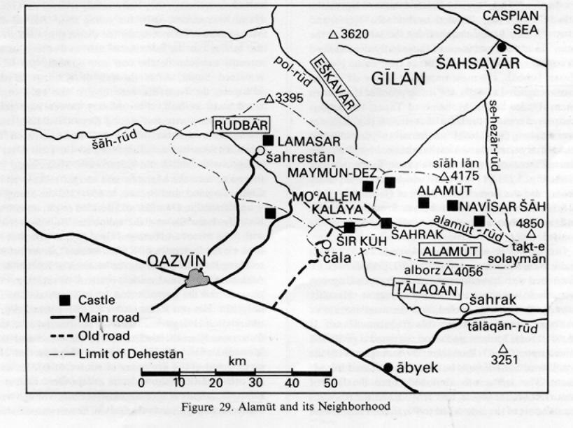
ALAMŪT, a high, isolated valley in the Alborz thirty-five kilometers northeast of Qazvīn; the center of an autonomous Ismaʿili state, the valley was defended by numerous fortresses, one of which bears the same name (Figure 29).
The valley. The valley of Alamūt in Daylam comprises the present dehestāns of Alamūt and Rūdbār, which meet in the baḵš of Rūdbār-e Alamūt in the šahrestān of Qazvīn, the center of which is Moʿallem Kalāya. In spite of its fame and allure, Alamūt was rarely visited before the 20th century by western travelers, though many of them mentioned it, including Marco Polo. In 1832 Colonel Monteith reached the region of Rūdbār, and in 1836 J. Shiel, coming from Ṭālaqān, visited the Alamūt valley and the ruins of the fortress; A. Eloy made the same trip the following year. In the 1930s the systematic studies resulting from the visits of L. Lockhart in 1928, F. Stark in 1930, and especially W. Ivanow beginning in 1928 became available. In spite of the relatively systematic but anecdotal archeological survey of P. Willey in 1960, the valley is still not well known except for its role in medieval history.
The powerful river of Alamūt originates on the western slope of Taḵt-e Solaymān (4,850 m); after joining the Rūd-e Ṭālaqān, it forms the Šāh-rūd, which traverses the central and eastern Alborz from east to west. The valleys of Rūdbār and Alamūt lie among the peaks of the Sīāh Lān (4,175 m) range to the north and the Alborz (4,056 m) and Qazvīn mountains to the south. For the most part the two valleys, which extend approximately 100 km, lie at an altitude lower than the 900 to 1,500 m range of the Iranian plateau. Although entirely surrounded by mountains, Alamūt enjoys a mild climate with Caspian influences; hence rice is cultivated, and malaria existed in Rūdbār up to a recent date. Snow remains on the heights for a long period but disappears rapidly in the valley, which receives an annual rainfall of between 300 and 500 mm. Like the neighboring valley of Ṭālaqān, Alamūt is formed of clayey conglomerates dating from the Miocene epoch. It is bordered in the south by mountains composed of volcanic “green rocks” of the Tertiary period, and in the north by high chains of a complex structure where limestones of the primary era predominate. The action of the rivers is strong, and catastrophic floods are frequent, often causing the collapse of roads and the devastation of fields. Although the valley belongs to the Caspian watershed of the Alborz, it conforms bio-climatically to the southern watershed with Artemisia and Astragalus on the steppe-like mountain slopes, hawthorn shrubs (Crataegus aronica) between 1,000 and 2,000 m, and no forest zone. Everywhere there are signs of the predatory activity of man. Three types of landscape are clearly distinguishable: in the upper part the small valleys of the cold high mountain of the dehestān of Alamūt, in the middle the high interior plains and the valleys of Rūdbār, and finally the narrow main valley, especially downstream where inhabitants are few.
Access to Alamūt is difficult because of the narrow gorges and surrounding mountains. The traditional mule trail from the plateau, a two-day trip from Qazvīn, crossed the Čāla pass, which rises above the confluence of the Alamūt and Ṭālaqān rivers. The automobile track constructed around 1960 along this trail has been replaced by a modern road farther west through the Qesṭīnlār pass (2,350 m). Downstream, a road enters the village of Šahrestān and the Rūdbār valley. Since 1973 tracks have gradually opened up most of the villages, which have been linked to Qazvīn by daily buses (fourteen in the dehestān of Alamūt in 1977); access to certain villages remains difficult because of the absence of a road along the river and the lack of bridges.
In 1345 Š./1966 there were slightly more than 40,000 inhabitants in the baḵš of Rūdbār-e Alamūt. The construction of roads has accelerated migrations toward the industrial zone of Tehran-Qazvīn; return visits are made only for summer vacations. Seasonal migrations for work to the Caspian plain were rare in this area. The villages grouped around Moʿallem Kalāya provide numerous commercial items and basic equipment, but they do not constitute a real business center. The other villages of more than 500 inhabitants (a total of fifteen) are almost totally lacking in businesses and services because of the former seclusion that favored self-sufficiency and domestic crafts (bread, clothes, shoes, tools, small carpets, gelīms, etc.). Commercial relations were active with the neighboring valleys to the south (Ṭālaqān, Čālūs, Karaǰ) and the north (Eškavar, Kalār-dašt, the region of Šahsavār). Muleteers, numerous in Alamūt before the opening of the roads, are still found in the more elevated villages, whose inhabitants regularly sell their products, make their purchases, and grind their wheat in the Ṭālaqān valley. Relations with neighboring valleys are facilitated by the similarity of the dialects. Apart from four Turkish-speaking villages higher up, the inhabitants of Alamūt speak Gīlakī and those of Rūdbār Tātī. There are numerous differences of detail, since these dialects all represent various intermediary forms between the Caspian languages and the colloquial Persian of Tehran, which is not well understood by everyone in the area. On the Qazvīn plain, most of the villages are Turkish. The ethnic relationship with the Caspian populations is apparent in certain villages of the valley (Šahrak, Moʿallem Kalāya), where many houses have two stories and covered galleries as in Gīlān. In the mountain villages, the houses are always flat-roofed and laid out in steps, without the inner court and veranda that often characterize the houses of Rūdbār. Throughout the valley roofs of sheet iron are extremely rare. In the dehestān of Rūdbār, many villages (e.g., Dīkīn, Vošta, Garmārūd) are inhabited, at least in part, by a little-known community known as the Marāḡī, who are completely isolated in terms of their mosques, public baths, costume, language, etc.; but who apparently live on good terms with the other inhabitants, whom they call Pašaʾī. The Marāḡī are officially Shiʿite like the other inhabitants of the region, but they seem to have maintained both Zoroastrian and Ismaʿili customs (see Ivanow, Alamut; Varǰāvand, Sarzamīn, pp. 468-73).
Until the agrarian reform, the villages of the valleys were dominated by large land-owners residing in Ṭālaqān, Qazvīn or Tehran; only the villages of shepherds at high altitudes belonged to their inhabitants. Most of the villages are situated on the slopes of the right bank of the valley, exposed to the south and sheltered from floods. The agricultural economy is still dominated by grains. Rice is grown in small plots at the base of the main valley below Šahrak (1,500 m) with water provided by small streams (the main river is difficult to use because of great variations in level). When water is scarce, wheat replaces rice. On the high terraces and the plateaus of the interior basin, wheat and barley are sown without irrigation in a two-year rotation; in alternate years the land is left fallow to be grazed by the communal cows. The large plots are often separated by hedges (talū) and sometimes dotted with hawthorn (zālzālak; Crataegus aronica), whose berries are eaten in autumn. A countryside of worn-out pasture land is especially apparent near Qesṭīnlār and Gāzorḵān. Tilling is done with swing-ploughs pulled by oxen; the sheaves of wheat are transported on the backs of men or donkeys to the threshing-floors located near the villages. Since the process requires a large amount of manual labor, this form of agriculture is gradually being abandoned. The grain is ground and consumed locally or sold to neighboring villages.
In the more elevated villages, the primary crops are vegetables, such as beans and onions, and increasingly fodder, potatoes, sugar beets, and fruit trees, such as hazelnuts and apples. In response to the expanding urban market for fruits, orchards are being planted in the valleys with a southern exposure (Eskīrīn, Hīr, Zavār-dašt). In general, Rūdbār and especially Alamūt are poor agriculturally, since they suffer from lack of water. The population lives primarily on bread, dried fruit, and milk products; rice is still a rare food.
Sheep raising (50 to 60,000 head) is a traditional occupation that fares better than agriculture. In the dehestān of Alamūt, the shepherds guard the animals in summer in high enclosures often at a distance of a four-hour march. In winter the herd is fed in the village with forage collected on the mountains and brought down by hand. In spring, and sometimes in autumn, many of the sheep are brought down to graze in the fallow fields of the Rūdbār river and Qazvīn plain. The shepherds of Alamūt are often hired by neighboring valleys (Ṭālaqān, Karaǰ, Nūr). Cattle play an important role in the grain producing villages of Rūdbār. The herd is kept collectively, guarded by a hired hand or the proprietors in turn. In summer, cows are kept near the village while calves and oxen are left unguarded in the high mountains; they are only brought down to the village to work at the threshing and to feed on the stubble fields.
A decline in both animal husbandry and agriculture is gradually being compensated for by the introduction of new crafts, such as the weaving of Qom and Nāʾīn carpets under contract, and the revival of traditional crafts, such as the weaving of local carpets and gelīms, which find a good market among the increasingly numerous tourists who come to visit the “castles of the Assassins.”
The Ismaʿili state (483-654/1090-1256). The valley of Alamūt formed part of Daylam, whose Buyid rulers (320-447/932-1055) conquered ʿErāq-e ʿAǰam before taking control of the ʿAbbasid caliphate in Baghdad. The invasion of the Saljuq Turks put an end to this “Iranian intermezzo” (V. Minorsky), but not to the seat of rebellion located in the Daylam mountains. Conquered by the Ismaʿilis, Alamūt became the center of an isolated Shiʿite state that was to last 166 years and pursue the objective of breaking the domination of the Sunni Saljuqs. Composed of communities scattered from Syria to Khorasan and protected by numerous fortresses, the Ismaʿili commonwealth was not a state in the economic and social sense, but rather a religious community directed by a dāʿī (“summoner,” the representative of the imam) and organized on a military basis; it has been compared with the chivalric orders of monks during the crusades. Living among hostile populations, the Ismaʿilis were often victims of massacres to which they responded with spectacular political assassinations. These “holy crimes” planned at Alamūt were carried out by fedāʾīs, who rarely survived and were thus considered martyrs. The use of terrorism, a tendency toward secrecy and esoterism, and a rigid hierarchy favored the development of romantic legends and earned the Ismaʿilis such pejorative epithets as bāṭenī or molḥed in Iran and ḥašīšīya (those who smoke hashish) in Syria; from the last derives the western world “assassin” (cf. EI2 III, pp. 267-68). The crusaders and Marco Polo were to immortalize the leader of the Assassins as “The Old Man in the Mountain.” Fear of the small state of Alamūt spread not only in the neighboring regions (Rūyān, Gīlān, Qazvīn) but also throughout the Muslim world. The library and astronomical facilities of Alamūt were famous; its fortresses were a haven for scholars and political figures who had fallen out of favor. This was in stark contrast to the less cultured Daylamite mountain dynasties of the preceding centuries.
The state of Alamūt was founded at the time of the progressive weakening of the Fatimid regime in Egypt that began in 468/1060 and put an end to any hope of Ismaʿili domination. The Ismaʿilis in Saljuq Iran were victims of increasingly severe repression that provoked a revolt led by the dāʿī of Isfahan, ʿAbd-al-Malek b. ʿAṭṭāš, at the end of the reign of Malekšāh (478/1080). In order to regroup their forces territorially and realize their dream of a society on the margin of the Muslim world, the Ismaʿilis captured many fortresses in Kūhestān, the south of Khorasan, Fārs, Qūmes, the Zagros, and Syria; in 483/1090, Ḥasan Ṣabbāḥ, ʿAbd-al-Malek’s lieutenant, took the castle of Alamūt in Shiʿite Daylam and made it the center of the movement. In 485/1092 a Saljuq counterattack was repulsed, and the death of Malekšāh gave the Ismaʿilis a respite to organize and buttress the new state; they supported, then annexed, the small local regimes that resisted Saljuq domination (e.g., Lamasar, taken by Bozorg-ommīd, Ḥasan Ṣabbāḥ’s lieutenant). In 487/1094, with the death of Mostanṣer, the Fatimid imam in Egypt, the title of imam was disputed by his sons Nezār and Mostaʿlī and finally acquired by the latter. But the Ismaʿilis of Iran and some of those in Syria continued to consider Nezār as imam; hence their name Nezārī. Ḥasan Ṣabbāḥ, the most important of the dāʿīs, was then recognized as ḥoǰǰa, the living proof of the hidden imam. Under Sultan Moḥammad Tapar, the Saljuqs recaptured some of the Ismaʿili fortresses (e.g., Šāh-dez near Isfahan, 500/1107); but for seven years Alamūt successfully resisted the attacks launched by Šīrgīr, the amir of Sāva, owing its final salvation to the death of Moḥammad (511/1118), after which the Saljuq army abandoned the siege. By the death of Ḥasan Ṣabbāḥ in 518/1124, the state of Alamūt was firmly established and many fortresses of the Alborz were under its control.
During the reigns of Bozorg-ommīd (d. 532/1138) and his son Moḥammad (d. 557/1162), periods of peace alternated with operations of defense or reprisal against immediate neighbors or the Saljuq regime. Hostility toward the Fatimids cooled, and the assassination of ʿAbbasid notables became less frequent. Ḥasan II (d. 561/1166), Moḥammad’s son, initiated a profound innovation: On 17 Ramażān 559/8 August 1164 he proclaimed himself ḥoǰǰa but in fact considered himself imam. The šarīʿa was abolished, since the Day of Resurrection, the qīāma, had arrived, and the Ismaʿilis formed part of the elite called to Paradise. Thus, Ḥasan II placed himself outside the Muslim community, though the spiritual qīāma implied that the traditional moral precepts of the šarīʿa would be followed in daily life. Those opposed to this new theology were numerous, and Ḥasan was assassinated. During the long reign that followed, Ḥasan’s son, Nūr-al-dīn Moḥammad II (d. 607/1210), consolidated the work of his father, whom he pronounced the true imam, the secret son of a descendent of Nezār who had hidden at Alamūt. The state continued to be involved in conflicts with Qazvīn, the rulers of Māzandarān, and, at the end of Moḥammad’s rule, with the Ḵᵛārazmšāhs, whose power was increasing while that of the Saljuqs declined. At the same time the Ismaʿilis of Kūhestān continued to war with the Ghurids, while those of Syria, led by Rašīd-al-dīn Senān, were nearly independent of Alamūt.
The decline of Alamūt began with the versatile Jalāl-al-dīn Ḥasan III (d. 618/1221), who succeeded Moḥammad II in 607/1210. He proclaimed himself Sunni, restored the šarīʿa, and undertook a policy of reconciliation that was interpreted as the opening of a new age of concealing the faith (satr). He established friendly relations with the Ḵᵛārazmšāhs, who controlled most of Iran and then with the caliphate. Along with Ūz-beg of Azarbaijan he made several temporary conquests (Zanǰān, Abhar), before returning to Alamūt, where his theological revolution had been accepted at least outwardly. About the time when refugees fleeing the advance of the Mongols began to arrive in the Ismaʿili territory of Kūhestān, Ḥasan III became the first Iranian sovereign to offer them his submission, though they had scarcely crossed the Oxus. Ḥasan was succeeded by his young son, ʿAlāʾ-al-dīn Moḥammad III. Once again the qīāma prevailed over the šarīʿa, but the doctrine of satr was refined in an attempt to reconcile the two and officially the state remained Sunni. After the fall of Ḵᵛārazm to the Mongols, the Ismaʿilis were almost the only organized state in Iran, their military power reinforced by numerous fortresses, among them Gerd Kūh near Dāmḡān; a number of learned men gathered in Alamūt’s security, including Naṣīr-al-dīn Ṭūsī. After a struggle with Jalāl-al-dīn Ḵᵛārazmšāh, Moḥammad III turned to face the Mongols and sought allies even in China, England, and France. In 650/1252 the Mongols were installed in Dāmḡān and decided to put an end to both the Ismaʿilis and the caliphate. Hülegü arrived with fresh troops and besieged Gerd Kūh in vain; but he took all the fortresses of Kūhestān and Qūmes before reaching Ray and attacking the bastions of Rūdbār and Alamūt. Moḥammad made a pretense of resisting, but panic seized his generals and he was assassinated in 653/1255. His son Rokn-al-dīn Ḵᵛoršāh opened negotiations, but Hülegü demanded the destruction of all the fortresses. Ḵᵛoršāh tried to evade the issue and the Mongol leader laid siege to him at Maymūn-dez. He surrendered at the beginning of winter, 654/1256, and the other citadels followed suit, except Gerd Kūh and Lamasar, in spite of Ḵᵛoršāh’s instructions. Though well treated at Hülegü’s court in Qazvīn, he was assassinated the following year on his return from a visit to the court of Möngke Khan that he had made at his own request. Shortly thereafter the Ismaʿilis of Iran were systematically massacred by the Mongols with the approval of the Sunnis. Since then, with the exception of a brief period of Ismaʿili reconquest in 673/1275, the region of Alamūt has never been a politically autonomous region within Iran, and the Nezārī Ismaʿilis have remained dispersed.
The fortresses of Alamūt. Each of the Ismaʿili fortified sites in Rūdbār and Alamūt is perched on rocky heights and was well-equipped to withstand long sieges, thanks to a vast capacity to store provisions and an elaborate system of cisterns, qanāts, and canals. The fortress of Alamūt as such, where Ḥasan Ṣabbāḥ resided, is located near the village of Gāzorḵān and gave its name to a particular region of Rūdbār; it has often been described (see the works of Ivanow and Willey). According to legend, an eagle indicated the site to a Daylamite ruler; hence the name, from aloh (eagle) and āmū(ḵ)t (taught). Rūdbār was the traditional seat of the Jostanid kings of Daylam, one of whom is said to have constructed the fortress of Alamūt in 246/860. Later the fortress was in the hands of Zaydī ʿAlids, until its capture by the Ismaʿilis, who reinforced it. The castle was erected at an altitude of 2,000 m on a rocky crest accessible only by a narrow grass turf bank. It has never been taken by force; Ḥasan Ṣabbāḥ seized it by trickery and the Mongols took it only after it surrendered without combat. The headquarters and symbol of Ismaʿili resistance to Sunnism, it was partially dismantled by the Mongols and its famous library burned except for a few “non-heretical” works saved by the historian Jovaynī. Restored under the Safavids to serve as a prison, the castle was gradually destroyed by time and local inhabitants searching for hidden treasure. However, the existing ruins are sizable.
The castle of Maymūn-dez, discovered in 1960 by Willey, is situated near Moʿallem Kalāya. Constructed by Bozorg-ommīd in 520/1126, it consists of a number of natural and man-made caverns on an elevated and practically inaccessible cliff. The exterior fortifications have almost totally disappeared. Other caverns of the same type are found near Andaǰ several kilometers to the east. The largest and most complex of the castles is Lamasar. Built on a hill to the north of the village of Šahrestān, thirty kilometers downstream from Alamūt, it was taken over by the Ismaʿilis shortly after their conquest of Alamūt, and its fortifications were reinforced. Its ruins are well preserved. With the exception of Semīrān, which overlooks the pass to Manǰīl far from Alamūt, the remaining fortresses of Rūdbār and Alamūt are of smaller size and were specifically designed to guard the roads to the castles. Šīr Kūh was constructed on the rocky banks of the confluence of the Alamūt and Ṭālaqān rivers. Navīsar Šāh farther upstream controlled the hills toward Kalār-dašt and the Caspian, as did Elān, situated more to the west. The ruins of a large number of other fortresses are found in the Alborz; many of them probably belonged to the Ismaʿilis, but the historical research necessary to establish this has not been carried out.
Bibliography
The basic work on the history is G. S. Hodgson, The Order of the Assassins, The Hague, 1955, which contains a full bibliography; the same author reviews and corrects this work in “The Ismaʿili State,” Camb. Hist. Iran V, pp. 422-82.
Archaeology: W. Ivanow, Alamut and Lamasar, Tehran, 1950.
P. Willey, The Castles of the Assassins, London, 1963.
M. Sotuda, Qelāʿ-e Esmāʿīlīya, Tehran, 1345 Š./1967.
General: S. de Sacy, “Mémoire sur le dynastie des Assassins et sur l’origine de leur nom,” Mémoires de l’Institut Royal 4, 1818, pp. 1-85 (Mémoires d’histoire et de littérature orientales, Paris, 1818, pp. 322-403).
J. von Hammer, Geschichte der Assassinen, Stuttgart, 1818.
Monteith, “Journal of a Tour through Azerbijan and the Shores of the Caspian,” JRGS 3, 1833, pp. 1-58.
J. Shiel, “Itinerary from Tehran to Alamut and Khurrem Abad in May 1837,” JRGS 8, 1838, pp. 430-34.
A. Eloy, Relations de voyages en Orient de 1630-1838, Paris, 1843, p. 774.
L. Lockhart, “Hasan-i Sabbah and the Assassins,” BSOAS 5, 1930, pp. 675-96.
W. Ivanow, “The Dialect of Gozärkhon in Alamut,” Acta Orientalia 9, 1931, pp. 352-70.
F. Stark, The Valley of Assassins, London, 1934.
V. Minorsky, “La domination des Dailamites,” Iranica, Tehran, 1964, pp. 12-30.
B. Lewis, The Assassins, a Radical Sect in Islam, London, 1967.
P. Varǰāvand, Sarzamīn-e Qazvīn, Tehran, 1349 Š./1970.
J. Calmard, “Le Chiisme imamite en Iran à l’époque seljoukide,” Le Monde Iranien et l’Islam I, Paris and Geneva, 1971, pp. 43-67.
R. N. Annels et al., Explanatory Text of the Qazvin and Rasht Quadrangle Map 1/250 000°, Geological Survey of Iran, 1975.
Figure 29. Alamūt and its Neighborhood