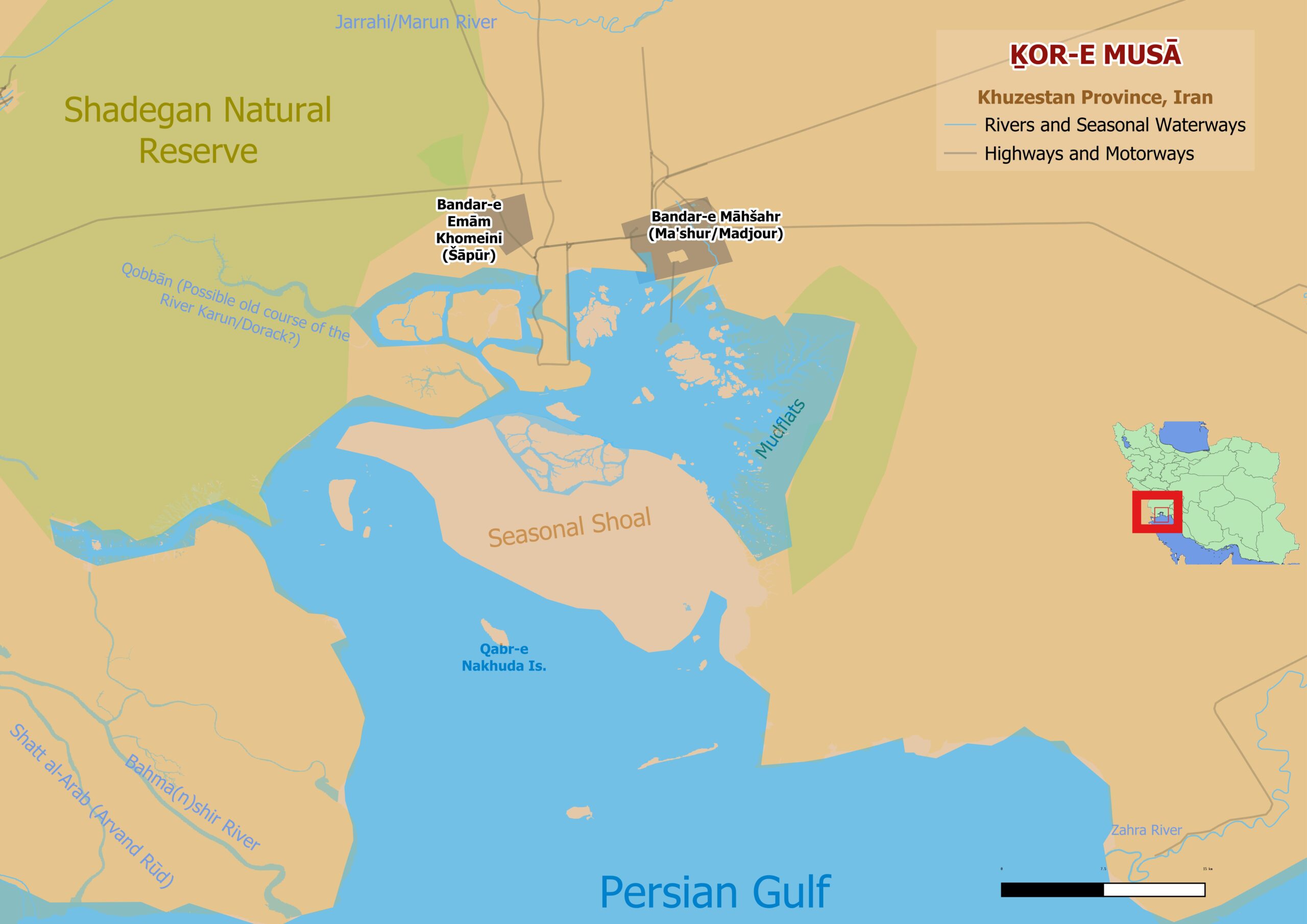


Figure 1. The Bay of Ḵor-e Musā and its surroundings.
(Ḵowr-e Musā; Khor Musa; Musa Bay), a north-south running, tidal inlet about 64 km long, situated north of the Persian Gulf and approximately 48 km east of the mouth of the Shatt al-Arab (Leader, 1929, 244), and a village at the head of it, within the province of Khuzestan (N 30° 05′ 20′′ E 48°59′08′′). The Karun, or “Dorack” river (Horsburgh, 1817, 421) debouched into it until its course changed in 1766 to flow into the Shatt al-Arab (Harrison, 1942, 45). Fresh-water springs once bubbled up and emptied into it (Harrison, 1942, 51). It has also been known as “Khor Musu,” “Khor Moosa,” “Moï Allah” (Ainsworth, 1888, 183- 85), and “Kore Moosah” (Horsburgh, 1817, 421). It is divided in two by a shoal called Kaseir bint Sisuan (Qassār bin Siswān) and the narrow bank that extends south of it. The area to the west, on the side of Khor Bahmishir [Ḵor-e Bahmanšir], is low and swampy” (Constable and Stiffe, 1890, 293). It also appears as “Chôr Maʿšûr” (Ḵor-e Māhšahr) on some naval charts (Sachau, 1916, 966). The Nahr Buzi, a branch of the Jarrāḥi river, also empties into the Persian Gulf at Ḵor-e Musā (MacGregor, 1871, 196), creating a large tidal fan (Walstra et al., 2010, 274) that was covered with water at high tide but formed a vast area of mud-flats at low tide with many small islands (Leader, 1929, 244; Bourke-Burrowes, 1931, 41). Soundings taken during marine surveys in the 19th century determined that depths in Ḵor-e Musā ranged from 4 to 18 fathoms (Brucks, 1856, 581; MacGregor, 1871, 247). Describing his visit to Ḵor-e Musā in 1902, Rear-Admiral Henry Boyle Townshend Somerville (1863-1936) wrote that “there stretched on all sides of us a brown sandy plain, flat, smooth, devoid of life, reaching everywhere to the horizon” (Somerville, 1920, 818). Commander Walter Sinclair (1905) and Commander Charles William Shearme (1907) both authored reports on their marine surveys of Ḵor-e Musā. In times of extreme flooding the Shadegan Marshes (Bāṭlāq-e Šādegān) empty into Ḵor-e Musā (Walstra et al., 2010, 269).
Ḵor-e Musā has sometimes been identified with the ancient Mosaios river (Gk.: Μώσαιοϛ, Cl. Ptolemy 6.3.2; see e.g., Vincent 1797, 394; Ainsworth 1890, 116; Wilson 1929, 510). Wilhelm Tomaschek identified the Pylodes kolpos (χόλποϛ Πηλώδηϛ) of Ptolemy and Illodes of the Cosmographia of Ravennas Anonymous with the marshy area on the west side of Ḵor-e Musā (Tomaschek, 1890, 75; Potts, 2018, 62). Derah (Dārā) island in Ḵor-e Musā has been identified with Margastana, “a small island” at the mouth (Arrian, Anab. II. Indica, 41.2; see Chesney, II, pp. 354-55; Potts, 2019a, 386) of “a lake, full of fish called Cataderbis” (Arrian, Anab. II., Indica 41.2; Tomaschek, 1890, 73; Wilson, 1929, 513; by the late 20th century commercial fishing in Ḵor-e Musā was greatly reduced; see Abbes and Farrugio, 1977, 9, 11). J. B. B. d’Anville identified Arrian’s Caterderbis with site of the “Bender Madjour” (Bandar-e Māhšahr) on the shores of the lake or inlet in the northern Persian Gulf mentioned in the Jehān-nomā (1732) of Kâtip Çelebi (1609-57) and thus inferred that Cataderbis denoted the Ḵor-e Musā (Bourguignon d’Anville, 1764, 169; Potts, 2019b, 342). Similarly, John Watson McCrindle (1825-1913), who identified the bay of Cataderbis as “that which receives the streams of the Mensureh and Dorak,” and at the entrance of which “lie two islands, Bunah and Ḍeri” (McCrindle, 1879, 218, n. 87), also implied its identification with Ḵor-e Musā.
By 1745, a geomorphological change to the Ḵor-e Qubbān (Ḵor-e Abu Ḵażayr), through which the Karun entered the Persian Gulf (Wilson, 1925, 233), prompted the Banu Kaʿb tribe, who had been resident at Ḵor-e Qubbān on the Persian Gulf, to move further north to Dawraq or Dawraq al-Falāḥiya (formerly a settlement in south-western Ḵuzestān, also called Dawraq al-Furs ‘Dawraq of the Persians’; Lorimer, 1908, 961; Floor, 2006, 281). With the death of Nāder Shah two years later, the Banu Kaʿb were able to oust the Afšārs from Dawraq while maintaining their hold over Ḵor-e Qubbān (Perry, 1971, 134-35). Ḵor-e Musā thus came under Banu Kaʿb control. In 1761, when Alexander Douglas, the British East India Company Resident at Bandar-e ʿAbbās, was on a tour of inspection to the Residency in Basra, ʿAli Āqā, the Ottoman-appointed governor there, prevailed on him to help organize a blockade of Ḵor-e Musā, using the Company’s brig Swallow and some smaller vessels in order to compel Shaikh Salmān, the Banu Kaʿb chieftain, to pay his taxes (Perry, 1971, 136-37). The effort failed as the Banu Kaʿb were able to retire inland to Dawraq (Perry, 1979, 163). The Banu Kaʿb found themselves claimed, for purposes of taxation, by both the Ottoman and Zand regimes, and March 1766 saw the start of a bootless East India Company naval campaign up the Ḵor-e Musā in response to the Banu Kaʿb seizure of three of its vessels, the Sally, the Fort William, and an unnamed yacht, the previous year (Lorimer, 1915, 140; Perry, 1971, 143-45; Floor, 2006, 285)
In 1902, fearful of Persia granting Russia permission to build a naval base in the Persian Gulf, contingency plans were drawn up and reconnaissance surveys were undertaken with a view to bolstering Britain’s position there. One of the coastal areas surveyed was Ḵor-e Musā (Somerville, 1920, 812-25; Busch, 1967, 254). The results of these surveys were published in the 1924 edition of the Persian Gulf Pilot (Wilson, 1929, 511). Already in 1906 Lord Ellenborough (1841-1915), a British Royal Navy officer and member of the House of Lords, raised the possibility of Ḵor-e Musā becoming the southern terminus of the Baghdad Railway, in preference to either Basra or Kuwait (Wilson, 1929, 512). The Khor Musa Agreement, whereby Ḵazʿal Khan, the chieftain of the Banu Kaʿb tribe of Ḵuzestān, entered into an agreement to give the British first refusal for the lease of land around Ḵor-e Musā, was signed in 1912 (IOR, File 240/1913). In 1924, an aerial survey was conducted of Ḵor-e Musā and the adjacent mud flats (Wilson, 1929, 513).
In 1927, American engineers surveyed, charted, and buoyed the deep channel leading into the Ḵor-e Musā from the Persian Gulf (Leader, 1929, 244). Writing in 1929, Arnold Talbot Wilson (1884-1940) noted the presence of only two landmarks, a small, ruined mud brick fort known as the Kut “of Mister Zubaid el Farangi” (al-Maʿqil, in Basra district) and the tomb of an unknown pilot, “Qabr-an-Nakhuda” (Qabr-e Nāḵodā) (Wilson, 1929, 512). When the Pahlavi dynasty (r. 1925-79) decided to construct a Trans-Iranian railway (Rāhāhan-e sarāsari-ye Irān; see RAILROADS i. THE FIRST RAILROAD BUILT AND OPERATED IN PERSIA), joining the Caspian Sea and the Persian Gulf, the village of Ḵor-e Musā (later Bandar-e Šāhpur, present-day Bandar-e Emām Ḵomeyni; for the name change see Field, 1939, 256) was chosen as its southern terminus (McClenaghan, 1931, 110). The site chosen had the virtue of not being located within the contested Shatt al-Arab, over which a dispute with the new nation of Iraq was then simmering, and of being as far from British India as possible.
Hence, political reasons (Melamid, 1959, 211) and nationalist concerns (Lemańczyk, 2013, 239) played a role in the choice of Ḵor-e Musā. The location, however, proved costly as it required the construction of a bridge across the Karun river at Ahvāz as well as a very long pier and causeway across swampy ground (Melamid, 1968, 355). In 1938- 39, an enquiry into the viability of the construction of an oil refinery and pipeline and tanker terminal on Ḵor-e Musā found that, with some dredging, the inlet could be made usable by tankers of up to 40,000 tons (Melamid, 1959, 211). The Second World War put a halt to those plans but by 1948 a new port, Bandar-e Māhšahr, was opened on Ḵor-e Musā “for the sole purpose of delivering Agha Jari [see ĀḠĀJĀRI] crude oil by gravity-flow pipeline to tankers” (Melamid, 1959, 213). Ḵor-e Musā is today dominated by the petrochemical and container port of Bandar-e Emām Ḵomeyni. The possibility of harnessing tidal energy to generate electricity in Ḵor-e Musā has been explored in recent years (Hashemi Aslani et al., 2017, 15-22).
Bibliography
Abbes, René and Henri Farrugio. Analyse des Activités de Pêche traditionnelle en Iran, entre Khoramshar et Busher et Résultats des Pêches experimentales effectuées dans le Golfe d’Oman. Mission du 28 février au 23 mars 1977. Nantes: 1977.
Ainsworth, William Francis. A Personal Narrative of the Euphrates Expedition, vol. 2. London: Kegan Paul, Trench, and Co., 1888
——.The River Karún, An Opening to British Commerce. London: W.H. Allen, 1890.
Arrian. Anabasis of Alexander, Volume II: Books 5-7. Indica. Translated by P. A. Brunt. Loeb Classical Library 269. Cambridge, MA: Harvard University Press, 1983.
Bourguignon d’Anville, Jean-Baptiste. “Recherches géographiques sur le Golfe persique et sur les Bouches de l’Euphrate et du Tigre.” Mémoires de Littérature, tirés des Registres de l’Académie Royale des Inscriptions et Belles-Lettres 30 (1764): 132-95.
Bourke-Burrowes, D.R.S. “Changes and development in Persia during the Pahlevi régime.” Journal of the Royal Central Asian Society 18 (1931): 39-49.
Brucks, George Barnes. “Memoir descriptive of the Navigation of the Gulf of Persia; with Brief Notices of the Manners, Customs, Religion, Commerce, and Resources of the People inhabiting its Shores and Islands.” Selections from the Records of the Bombay Government N.S. 24 (1856): 531-634.
Busch, Briton Cooper. Britain and the Persian Gulf, 1894-1914. Berkeley/Los Angeles: University Presses of California, Columbia and Princeton, 1967.
Chesney, Francis Rawdon. The Expedition for the Survey of the Rivers Euphrates and Tigris, Carried on by Order of the British Government, in the Years 1835, 1836, and 1837. Vol. 2. London: Longman, Brown, Green, and Longmans, 1850.
Constable, C. G., and A.W. Stiffe. The Persian Gulf Pilot, comprising the Persian Gulf, Gulf of Omán; and Makrán Coast, 3rd edition. London: The Hydrographic Office of the Admiralty, 1890.
Field, Henry. Contributions to the Anthropology of Iran. Anthropological Series, vol. 29, no. 1. Chicago: Field Museum of Natural History, 1939.
Floor, Willem. “The Rise and Fall of the Banū Kaʿb. A Borderer State in Southern Khuzestan.” Iran 44 (2006): 277-315.
Harrison, J.V. “The Shatt-el-Árab.” Journal of the Royal Central Asian Society 29 (1942): 43-51.
Hashemi Aslani, Zohreh, Mohammad Hossein Niksokhana and Masoud Montazeri Namin.
“Assessment of the Potential of Harnessing Tidal Energy in the Khowr-e Musa Estuary in the Persian Gulf.” Environmental Energy and Economic Research 1 (2017): 15-22.
Horsburgh, James. India Directory, or Directions for Sailing to and from the East Indies, China, New Holland, Cape of Good Hope, Brazil, and the Interjacent Ports, compiled chiefly from Original Journals at the East India House, and from Observations and Remarks, made during Twenty-one Years Experience navigating in those Seas, vol. 1, 2nd ed. London: W.H. Allen and Co., 1817.
[IOR] India Office Records and Private Papers, British Library, London, “Mohammerah Khoremabad Railway: The Khor Musa Agreement,” IOR/L/PS/10/332, File 240/1913, available at https://www.qdl.qa/ archive/81055/vdc_100000000419.0x0000e3.
Katip Çelebi (Ḥāji Ḵalifa). An Ottoman Cosmography: Translation of Cihānnümā. Edited by Gottfried Hagen and Robert Dankoff; translated by Ferenc Csirkés, John Curry, and Gary Leiser. Leiden; Boston: Brill 2022.
Leader, Convoy. “Persia’s New Seaport.” Journal of the Central Asian Society 16 (1929): 244-6.
Lemańczyk, Szczepan. “The Transiranian Railway – History, context and consequences.” Middle Eastern Studies 49 (2013): 237-45.
Lorimer, John Gordon. Gazetteer of the Persian Gulf, ’Omān, and Central Arabia, vol. II: Geographical and Statistical. Calcutta: Superintendent Government Printing, 1908.
——. Gazetteer of the Persian Gulf, ’Omān, and Central Arabia, vol. I: Historical, Part 1. Calcutta, Superintendent Government Printing, 1915.
MacGregor, C.M. Central Asia, Part IV: A Contribution Towards The Better Knowledge of The Topography, Ethnology, Resources, and History of Persia. Calcutta: Superintendent Government Printing, 1871.
McClenaghan, P.J.W. “A trip in North Persia, October, 1929,” Journal of the Royal Central Asian Society 18 (1931): 110-14.
McCrindle, John Watson. The Commerce and Navigation of the Erythræan Sea; Being a Translation of the Periplus Maris Erythræi, by an anonymous writer, and of Arrian’s Account of the Voyage of Nearkhos, from the mouth of the Indus to the head of the Persian Gulf. Calcutta: Thacker, Spink, and Co., 1879.
Melamid, Alexander. “The Geographical Pattern of Iranian Oil Development.” Economic Geography 35 (1959): 199-218.
——. “The Shaṭṭ al-‘Arab Boundary Dispute.” Middle East Journal 22 (1968): 350-7.
Perry, John R. “The Banū Ka‘b: An ambitious brigand state in Khūzistān.” Le Monde iranien et l’Islam 1 (1971): 131-52.
——. Karim Khan Zand: A History of Iran, 1747-1779. Chicago: University of Chicago Press, 1979.
Potts, Daniel Thomas. “The Persian Gulf in the Cosmographia of the Anonymous Geographer of Ravenna, c. 700 AD.” Dabir 5 (2018): 57-70.
——. “The Islands of the XIVth Satrapy.” In New Perspectives in Seleucid History, Archaeology, and Numismatics: Studies in Honor of Getzel M. Cohen, edited by Roland Oetjen, 375-396. Berlin: De Gruyter, 2019a.
——. “The Tools of an Enlightenment Geographer: Unmasking the sources in Bourguignon d’Anville’s 1758 treatise on the Persian Gulf.” In The Persian Gulf, an Archaeological Perspective, edited by Jabrael Nokandeh and Abdolreza Dashtizadeh, 325-361. Tehran/Qeshm: National Museum of Iran, 2019b.
Ptolemy, Claudius. Ptolemy, Geography Book 6: Middle East, Central Asia, China, Part 1: Text and English/German Translations. Edited and Translated by Helmut Humbach and Susanne Ziegler. Wiesbaden: Luwig Reichert, 1998.
Sachau, Eduard. “Von Christentum in der Persis.” Sitzungsberichte der Königlich Preussischen Akademie der Wissenschaften, philosophische-historische Klasse 39 (1916): 958-80.
Shearme, Commander C. W. Sketch Survey of Kannaka Creek, Khor-MusaI. Foreign Department Library, Shimla, India, No. 1384, 1907.
Sinclair, Commander W. F. “Rough Sketch Survey of Part of the Khor Musa and the Entrance to Hindian River.” Foreign Department Library, Shimla, India, No. 1383, 1905.
Somerville, Henry Boyle Townshend. “A Secret Survey I.” Blackwood’s Magazine 207 (1920): 812-25.
Tomaschek, Wilhelm. “Topograpische Erläuterung der Küstenfahrt Nearchs vom Indus bis zum Euphrat.” Sitzungsberichte der Kaiserlichen Akademie der Wissenschaften in Wien, philosophische-historische Klasse 121, no. 8 (1890): 1-88.
Vincent, William. The Voyage of Nearchus from the Indus to the Euphrates, collected from the original journal preserved by Arrian, and illustrated by authorities ancient and modern; containing an account of the first navigation attempted by Europeans in the Indian Ocean, London: T. Cadell, jun. and W. Davies, 1797.
Jan Walstra, Vanessa Mary. An Heyvaert, and Peter Verkinderen. “Assessing human impact on alluvial fan development: a multidisciplinary case-study from Lower Khuzestan (SW Iran.” Geodinamica Acta 23 (2010): 267-285.
Wilson, Arnold T. “The Delta of the Shatt al ‘Arab and Proposals for Dredging the Bar.” The Geographical Journal 65 (1925): 225-239.
——. “Khor Musa and Bandar Shapur.” Journal of the Central Asian Society 16 (1929): 510-13.