


GEOLOGY. This article is concerned with those aspects of the geology of Persia that are of immediate economic and cultural significance for the country and its inhabitants. The focus will therefore be on three aspects: (1) geological structure and orohydrographic differentiation of Persia; (2) geology and natural hazards; (3) geology and natural resources.
GEOLOGICAL STRUCTURE AND OROHYDROGRAPHY
FIGURE 1. Geological structural zones of Persia.
Put simply, Persia in a geological sense is characterized by the fact that on the one hand it belongs to the large Eurasian Tertiary mountain belt and, on the other, consists of the vast Iranian platform, resulting from the consolidation of a Precambrian basement which may be considered, according to some geologists, as an extension of the Precambrian Arabian Shield.
The juxtaposition of more or less stable remnants of Precambrian shield structures (“Median mass”) and geologically young elements such as the Tertiary mountain belts of the Alborz or Zagros are undisputed, but the interpretation of their development has undergone dramatic changes. Without going into details of the scientific history, one may summarize our present state of knowledge as follows:
a. Both in stratigraphy and structure, the Alborz and Central Persia are more closely interconnected than hitherto anticipated.
b. Palaeozoic orogeneses (between Upper Precambrian and Middle Triassic) are missing, which indicates that Central Persia must have experienced comparatively uniform continental to epicontinental conditions and more or less tectonic stability.
c. The Mesozoic and Tertiary areas are characterized by alpinotype orogeneses which cover all parts of Central Persia as well as its peripheries. In particular, peripheral fold belts such as the Kopet-Dag, the Makrān ranges, or the Zagros are included in geosynclinal developments, while the core of present-day Persia generally maintains its epicontinental character.
d. Contrary to other regions of the world, the Iranian mountain belts of Tertiary origin retain strong elements of their pre-Tertiary, even Precambrian orogeny.
e. New research indicates that the so-called “Median mass,” hitherto considered to be the already mentioned extensive remnant of an old Paleozoic basement, must probably be confined to only a small part of Central Persia, the so called “Lūt block.”
This oversimplified summary (for details, see bibliography) and the interpretation of the geological development of Persia are substantiated by the fact that no proof for Caledonian or Variscian orogeneses has so far been found. In addition, the sediments of Central Persia, on average 3,000 to 4,000 meters thick, are characterized by more or less homogeneous continental material of terrestrial origin with comparatively great uniformity. Moreover, these sediments are located over consolidated erosion surfaces of Triassic (or older) formations, sometimes even covering directly the Precambrian basement and erosion platforms.
Of special importance for the discussion of the geological development of Persia has been the theory of plate-tectonics. According to a number of geologists (Förster, Krumsiek, and others), Persia is seen as part of the old Gondwanaland. To them, paleogeographic and paleomagnetic data seem to indicate that according to this interpretation Gondwana-Iran was located somewhere between Somalia and present-day Persia. It is only since late and post-Cretaceous times that the Iranian plate has drifted into its present position. The collision of Arabian and Iranian plates is, according to this theory, the cause not only for the upfolding of the Zagros mountains, but also for the continuing volcanic and dramatic earthquake activities so characteristic of large parts of the country. In addition, the theory of plate-tectonics is potentially important for the understanding of mineral deposits, oil resources, etc.
The overall geological structure, according to Stöcklin (1968), can be differentiated into altogether nine structural zones: the plain of the Shatt-al-Arab; the folded belt of the Zagros; the Zagros thrust zone; the Sanandaj-Sīrjān ranges; central Persia (sensu stricto); the Alborz Mountains; the Kopet-Dag; the Lūt block; East Persia and the Makrān ranges.
The complexity and by no means uniform interpretation of the geological history and structure of Persia becomes apparent in the almost simultaneous analysis of the geology of Persia by Harrison (1970), who distinguishes altogether eight structural zones: (1) the Alborz system; (2) the Alborz foredeep; (3) the Ṭabas wedge; (4) the East Persian quadrangle; (5) the volcanic belt; (6) the complex belt; (7) the zone of normal folding; (8) the Makrān region (cf. also Figure 1).
Whatever the geological history of Persia may be in detail (see bibliography), one cannot deny the utmost importance of geology and tectonics for the orohydrographical and geomorphological development of present-day Persia. As indicated in earlier contexts (see ECOLOGY), Persia may be differentiated into five natural regions which have their very basis in the geology and geomorphology of the country: the Caspian lowlands; the Alborz system and mountain ranges of Khorasan; the Persian plateau; the Zagros system with the Makrān mountain ranges; and the lowlands along the Persian Gulf.
As pointed out above, the Caspian lowlands and the Alborz mountains have been extensively dealt with (including aspects of their geology) in their individual entries while the geomorphology and orohydrography of the Iranian plateau are a reflection of the overall geological structure. This holds especially true for the internal differentiation of drainage (q.v.) basins and watersheds.
The geological structure of Persia is decisively responsible for the fact that the Iranian plateau/central Persia is an endorheic basin that is entirely cut off from direct fluvial/hydrographic connections with the world oceans. The Alborz mountains and their eastward extensions in the north, and the Zagros-Makrān ranges in the west and south cause a geological-geomorphological barrier that secludes almost 50% of the land surface of Persia from direct access to and from the Indian Ocean. This huge land area of central Persia, which in the past and in a geologically simplified way was equated with the “Median mass,” is in fact an extremely complex geological structure.
A closer look at the geology of central Persia reveals its impact on the geomorphology and ecology of the country. In broad terms (for details cf. Harrison, 1970, pp. 127-42), the largest watersheds of the interior drainage basins are only understandable as a result of the geological development of central Persia and the structure of the Tertiary Alpine orogenesis: The folding and faulting have not only contributed to an extremely complicated juxtaposition of geological uplifts and depressions, but also to an overall highly fractured and fissured terrain and drainage system. The fact that neighboring interior basins such as the huge Great Kavīr with a size of more than 200,000 km2 and the Kavīr-e Lūt (166,160 km2) are not only located at different heights above mean sea-level, but are separated by folded mountain ranges of predominantly Tertiary origin speaks for itself.
GEOLOGY AND NATURAL HAZARDS
As indicated in other contexts (e.g., earthquakes, q.v.), the geology of the country is extremely important not only for the general topography and orohydrography of Persia, but also for a wide range of natural hazards. Among these, earthquakes are beyond doubt the most important, as shown by the extensive documentation of this feature under its own entry. Here the focus is on hazards resulting from earthquakes and associated geological events. Besides the basic fact that earthquakes occur very frequently in Persia, the sometimes devastating consequences are not restricted to tragic human and material losses, including the devastation of settlements and communication networks, but also to a great number of environmental consequences.
Mudflows, earthflows and other forms of mass movements are very common features of earthquake activities. As such they are most pronounced in earthquake-prone areas where slopes are formed by slippery silty clay soils and subsoils. Mudflows are prominent especially in volcanic ashes and in all forms of stratified deposits that are soaked with water and/or ice and that respond easily to seismic shocks such as earthquakes. This holds true especially for the somewhat humid areas of Northern Persia and its volcanoes (e.g., Damāvand), but is also valid for the highly vulnerable areas of salt diapirism of southeastern Persia.
Landslides are also caused by earthquakes and are favored by the existence of either thick regolith or by weak bedrock formations, especially where these are geologically fractured, heavily stratified, and intermitted by material that is soft, water absorbing and/or easily erodable.
Mudflows, earthflows, and landslides can cause much damage and destruction if the lower slopes or the valley floors are inhabited. Falling or slowly falling debris can also dam up streams in the valley bottom forming lakes, which eventually overflow or erode the dam and flood the valley below the slide.
GEOLOGY AND NATURAL RESOURCES
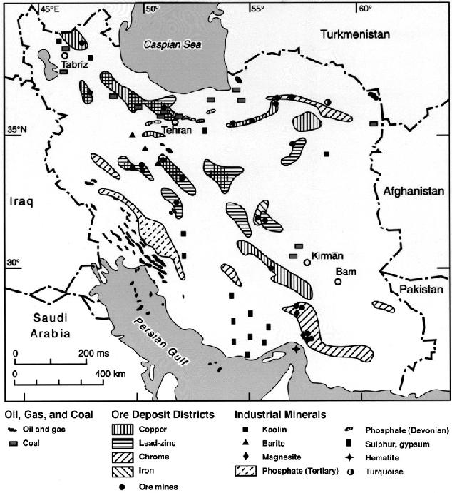
Figure 2. Distribution of mineral resources in Persia.
Persia is rich in minerals, and this richness is closely connected with its geological development and structure. Figure 2 indicates that these resources are spread all over the country. Quite a few of them are located in remote and isolated areas, others are only minor or low-grade deposits and economically not feasible. These handicaps may be one of the main reasons why, apart from coal, oil, and gas, mining is only of minor economic importance in most parts of the country.
Iron ore deposits (Figure 2) are a common feature in Persia and most of them are located between the southern slopes of the Alborz and within the Volcanic Belt or its fringe areas (cf. Figure 1). Although so far there has been little mining, some projects have been started or are under consideration: Čadoromlū, approximately 200 kms north east of Yazd, Gol-Gahar near Sīrjān and particularly the region of Kermān-Bāfq (with reserves of more than 1 billion tons) are considered promising iron ore deposits. The Bāfq mines are essential suppliers of the Isfahan Steel Mill. Also, copper (q.v.) deposits are widely dispersed in Persia and are mainly found in areas of Tertiary volcanic rocks (Bazin-Hübner, 1969) and even today many occurrences are only vaguely known and remain to be discovered. Very probably, the Čahār Gonbad district (Sjerp, Issakhanian, and Brants, 1969), about 110 km west-southwest of Kermān, and the region of Anārak are the most valuable and rich copper deposits, with the Sarčašma mine near Kermān being potentially one of the largest copper deposits in the world. Lead and zinc again, are concentrated in central Persia; however, both production plants in Zanjān province and near Bāfq are still at the stage of planning. Other mineral resources, all of them more or less economically unimportant and exploited (if at all) only at a local level, include chromite (q.v.; near Bāft, Sabzavār and close to Bandar-e ʿAbbās), magnesite (in the southern parts of Khorasan and Ardestān or manganese near Semnān and Bāfq.
Two mineral deposits deserve special mention: coal (q.v.) and phosphate. Coal is a common feature in many parts of Persia. The mining of coal has been a major business since the 19th century, especially near Tehran and in the Alborz. Although coal deposits have been known for centuries, their mining gained momentum from the 19th century onwards due to the exploitation of forests for charcoal production. Coal is still mined today in the Alborz and other locations near Tehran but increasingly, however, in Kermān province. Kermān and Zīrāb mines provide up to 800,000 tons of coal per annum, covering about 80 percent of the demand of the Isfahan Steel Mill. Phosphate, on the other hand, seems to be abundant with proven reserves of approx. 500 million tons. They are sufficient to meet the country’s annual phosphate fertilizer consumption of approx. 2.5 million tons. Phosphate deposits are located all over the country (Figure 2) with Bāfq in Yazd province being one of its major centers. Other deposits are located near Rāmhormoz, Behbahān, Dehdašt (in Ḵūzestān province), Šahrūd, Semnān, and near Tehran and Zanjān.
Natural gas and oil are of course the most important geological resources of Persia and of great national and international economic importance. In view of this it may suffice to say here that oil and gas reserves developed in connection with the upfolding of the Zagros mountain system. Centuries-old evidence of oil and gas seepage in Southwestern Persia in the foothills of the Zagros led to the discovery and development of these resources from the late 19th and early 20th centuries onwards and to the development of Persia’s highly important petroleum industry.
Bibliography
For a general bibliographical introduction see N. C. Rosen, of Geology of Iran, Geological Survey of Iran, Special Publication 2, Tehran, 1969.
The following bibliography contains mostly titles which have been published after 1969.
N. N. Ambraseys, “Historical Seismicity of North-Central Iran,” in J. S. Tchalenko et al., Materials for the Study of Seismotectonics of Iran: North-Central Iran, Geological Survey of Iran, Report 29, Tehran, 1974, pp. 47-96.
P. Bariand, V. Issakhanian, and M. Sadrzadeh, Preliminary Metallogenetic Map of Iran, Geological Survey of Iran, Report 7, Tehran, 1965.
H. Bazin-Hübner, Copper Deposits in Iran, Geological Survey of Iran, Report 13, Tehran, 1969.
M. Berberian, “Macroseismic Epicentres of Iranian Earthquakes,” in idem, ed., Contributions to the Seismotectonics of Iran, part III, Geological Survey of Iran, Report 40, Tehran, 1977, pp. 79-99.
Idem, ed., Contribution to the Seismotectonics of Iran, parts II-III, 2 vols., Geological Survey of Iran, Report 39-40, Tehran, 1976-77.
H. Bobek, “Die Salzwüsten Irans als Klimazeugen,” in Anzeiger Philosophisch-Historische Klasse Österreich, Akademie der Wissenschaften 3, Vienna, 1961, pp. 7-19.
M. D. Dimitrijevic, Geology of the Kerman Region, Geological Survey of Iran, Report Yu/52, Tehran, 1973.
J. Dresch, “Bassins arides iraniens,” Bulletin de l’Association de géographes français 430, 1975, pp. 337-51.
E. Ehlers, Iran: Grundzüge einer geographischen Landeskunde, Darmstadt, 1980, (esp. pp. 23-63).
N. L. Falcon, “Problems of the Relationship between Surface Structure and Deep Displacements, Illustrated by the Zagros Range,” in P. E. Kent et al., eds., Time and Place in Orogeny, Geological Society of London, Special Publication 3, London, 1969, pp. 9-22.
H. Förster, “Magmentypen und Erzlagerstätten im Iran,” Geologische Rundschau 63, 1974, pp. 276-92.
R. Furon, Géologie du plateau iranien, Musée national d’histoire naturelle, Memoires 7, n.s., fasc. 2., Paris, 1941, pp. 177-414.
A. Gansser, “Über Schlammvulkanismus und Salzdome,” Vierteljahresschrift der Naturforsch Gesellschaft 105, Zürich, 1960, pp. 1-46.
Idem, “The Large Earthquakes of Iran and Their Geological Frame,” Eclogae Geologicae Helvetiae 62, 1969, pp. 443-65.
Geological Survey of Iran, ed., Recent Phosphate Discoveries in Iran, Geological Survey of Iran, Report 10, Tehran, 1968.
J. V. Harrison, “The Saidmarreh Landslip, South-West Iran,” Geographical Journal 89, 1937, pp. 42-47. Idem, “Geology,” in Camb. Hist. Iran I, pp. 111-85.
J. V. Harrison and N. L. Falcon, “An Ancient Landslip at Saidmarreh in South-Western Iran,” Journal of Geology 46, 1938, pp. 296-309.
K. Krumsiek, “Zur Bewegung der Iranisch-Afghanischen Platte (Paläomagnetische Ergebnisse),” Geologische Rundschau 65, 1976, pp. 909-29.
A. Pilger, “Die zeitlich-tektonische Entwicklung der iranischen Gebirge,” Clausthaler Geologische Abhandlunger 8, Clausthal, 1971.
K. Scharlau, “Geomorphology,” in Camb. Hist. Iran I, pp. 186-94.
J. W. Schroeder, “Essai sur la structure d’Iran,” in Eclogae Geologicae Helvetiae 37, 1944, pp. 37-81.
N. Sjerp, V. Issakhanian, and A. Brants, The Geological Development of the Chahar Gonbad Copper Mine: A Study in Tertiary Copper Mineralization, Geological Survey of Iran, Report 16, Tehran, 1969.
A. F. Stahl, “Persien,” in Handbuch der regionalen Geologie V, Abt. 6, Heft 8, Berlin, 1911, pp. 1-46.
J. Stöcklin, “Structural History and Tectonics of Iran: A Review,” American Association of Petroleum Geologists Bulletin 52, 1968, pp. 1229-58.
Idem, Stratigraphic Lexicon of Iran, pt. 1: Central, North and East Iran, Geological Survey of Iran, Report 18, Tehran, 1971.
J. S. Tchalenko et al., ed., Materials for the Study of Seismotectonics of Iran: North-Central Iran, Geological Survey of Iran, Report 29, Tehran, 1974.
O. R. Weise, “Morphodynamics and Morphogenesis of Pediments in the Desert of Iran,” Geographical Journal 144, 1978, pp. 450-462.
A. K. Wells, “The Crush Zone of the Iranian Zagros Mountains and its Implications,” Geological Magazine 106, 1969, pp. 385-514.
G. J. Williams, ed., Contributions to the Geology of Mineral Resources in Iran, Geological Survey of Iran, Report 21, Tehran, 1973.