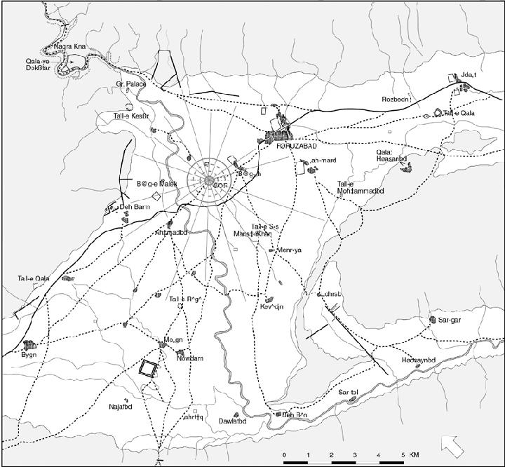


FĪRŪZĀBĀD, town and district (šahrestān) in Fārs, about 110 km south of Shiraz (lat 28° 50´ N, long 52° E, alt ca. 1,300 m; Gazetteer of Iran III, pp. 256-58, 292; Figure 1). The plain is 10 to 20 km wide and is abundantly watered by springs and the perennial Fīrūzābād river, the ancient Ḵonayfeqān or Borāza (Ebn al-Balḵī, pp. 134, 151; tr., pp. 39, 44). It is categorized by medieval geographers as belonging to the sardsīr (the cool climate) but on the border of the garmsīr (warm climate), hence regarded as especially agreeable. The main agricultural produce consists of grain, fruit, and vegetables. The partly wooded mountains are used for pasture. Until 1963, Qašqāʾī chiefs had their residence there with large traditional gardens, but it was later destroyed. There is a ruined qalʿa and a palace for the governor in the modern town, which lies 3 km east of the ancient city.
The name Fīrūzābād was bestowed by ʿAżod-al-Dawla (q.v.) in the 10th century, replacing the former names of Gōr (Jūr) and Ardašīr-Ḵorra. The rich literary tradition about the place pays special attention to the period of the downfall of the Arsacids and the emergence of the Sasanian empire in the early 3rd century C.E. The foundation of the city is ascribed to Ardašīr I in nearly all sources, including, inter alia, the Kār-nāmag (Nöldeke, 1879, pp. 47-48), Šahrestānhā ī Ērānšahr (Markwart, Provincial Capitals, p.19), Ḥodūd al-ʿālam (tr. Minorsky, p. 127), Ṭabarī (I, p. 820; Nöldeke, Geschichte der Perser, pp. 11 ff.), Eṣṭaḵrī (pp. 123-24), Ebn Ḥawqal (pp. 278-79; tr. Kramers and Wiet, pp. 274-75), Ebn al-Balḵī (tr., pp. 43-46), and Yāqūt (pp. 174-76). The attribution of its foundation to Pērōz by Ḥamd-Allāh Mostawfī (Nozhat al-qolūb, tr. Le Strange, p. 116) is obviously an arbitrary deduction from its later name. Although several chronicles give the impression that the town was founded after Ardašīr’s victory over Ardavān (see ARTABANUS), archeological and architectural-historical evidence prove conclusively the general correctness of Ṭabarī’s report, which dates it before the decisive battle and during Ardašīr’s struggle for supremacy. The Kār-nāmag, usually somewhat legendary, gives a short and seemingly realistic enumeration of Ardašīr’s activities concerning the place, among them the construction of water canals and a water tunnel cut through a mountain. Although embellished with legends later on, especially in Ebn al-Balḵī’s extensive report, these activities were essentially confirmed by archaeological observations. Information about the city itself and its plan are correct in general, and despite some confusion in the description of the main buildings they provide important detailed knowledge. The reference by Eṣṭaḵrī (p. 118) and Masʿūdī (Morūj II, p. 541) to a fire temple at a pond at Gōr gave rise to the incorrect interpretation of the great palace of Ardašīr in the plain as a fire temple (ātaškada).
The plain of Fīrūzābād has been inhabited since prehistoric times, with a major Chalcolithic site, Tall-e Rīgī, in the south (Stein, pp. 127ff.). Surrounded by precipitous mountains with few and easily defensible access roads, it was chosen by Ardašīr-e Bābakān as the key stronghold in his revolt against the last Parthian King. His building activities have made the area a unique monument of early Sasanian architectural planning. His founding of a city here, which he called Ardašīr Ḵᵛarra (Glory of Ardašīr) was a major violation of Parthian royal prerogatives and appears to have finally brought about his showdown with Ardavān in 224 C.E. (Nöldeke, Geschichte der Perser, pp. 5 ff.).
The plan of the old city was a perfect circle of 1,950 m diameter, divided into twenty sectors by a precise geometric system of twenty radial and several concentric streets. It was surrounded by a main wall of stamped clay, a ditch 35 m wide, and a fore-wall. Inside the town an inner wall set off the circular city center, which was probably the site for official buildings. The structures here and in the surrounding residential sectors must have been of mud brick, with two exceptions: The stone-mortar-masonry constructions of Taḵt-e Nešīn and the Ṭerbāl. The Taḵt-e Nešīn or Gonbad-e Kīrmān/Germān, which was erroneously understood as a čahārṭāq with open sides since its publication by Flandin and Coste (I, pls. 36-37; V, pp. 37-38), is actually the ruin of a cubical free-stone building with four rooms or ayvāns protruding from its four sides, the central room covered by a brick dome of 14 m in diameter (Huff, 1972) . It was probably Ardašīr’s fire temple, mentioned in the Kār-nāmag (Nöldeke, 1879, p. 48) and other sources. Some small Achaemenid-type column shafts nearby, often used as evidence for ascribing an Achaemenid date for the building, differ from each other and were certainly brought here for a secondary use. The tower-like Ṭerbālstands at the very center of the city. It is not clear whether the more ancient names of Ayvān Vekīāḵorra (Eṣṭaḵrī, p. 124) or Īrān Garda (Ebn al-Balḵī, p. 138; tr., p. 45) mentioned by medieval authors refer to this tower or to the Taḵt-e Nešīn, as both buildings are confused and described as one in the medieval sources. The Ṭerbāl is a pier of rough stone masonry 9 m square and more than 30 m high. It was the core of a stair-tower; with the width of the destroyed stairs and outer walls added, it must have been about 20 m long on a side. It was thought to have had a winding external stairway and to have been a descendant of the ziggurat, until Ernst Herzfeld recognized its true nature (Herzfeld, p. 255; Huff, 1969/70). It might have been part of a palace or government building and probably symbolized the divine and centralist kingship propagated by Ardašīr’s new state ideology. This need not have excluded practical use. The tower provided visual contact with the fortifications above the main access road to the plain in the gorge of Tang-āb, and, beside this military function, it must have been indispensable for surveying activities when the planning scheme of the town and plain was laid out. This scheme continues the concentric and radiant pattern of the town, at first up to an enclosure wall, forming a twenty-cornered polygon of nearly 8 km in diameter. Beyond this, the radials, consisting of traces of canals, paths, walls, and field borders continue up to 10 km distance from the central tower. The two perpendicular main axes of the scheme, determined by the axes of the tower and the four main gates, which are marked by four wide breaches in the city wall, lead to ruined constructions, which obviously belong to Ardašīr’s building program: a mud-brick ruin with a round moat and Sasanian surface pottery 9.5 km southeast of the city center was probably a fort, guarding the eastern entrance to the plain. Some 4.5 km northwest are traces of a garden designed with a circular pool and a building on a hill, also with Sasanian pottery. An arrangement of walls on a mountain plateau 6 km northeast could indicate a cemetery. About 10 km southwest, at the outlet of the river from the plain, are the remains of water conduits and of a single arched aqueduct. In an arid neighboring valley, beyond a mountain ridge, a wall, most probably of an aqueduct, runs exactly north-south in line with the tower beyond the ridge. The aqueduct was fed from springs in the eastern Fīrūzābād plain by a rock canal, penetrating the ridge by a rock tunnel (Huff, 1974, pp. 159-60, fig. 1). This is probably the actual background for the ancient and medieval reports about Ardašīr’s cutting through a mountain (Nöldeke, 1879, p. 48; Ebn Ḥawqal, p. 279; Ebn al-Balḵī, pp. 137-38, tr., pp. 44-45.).
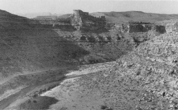
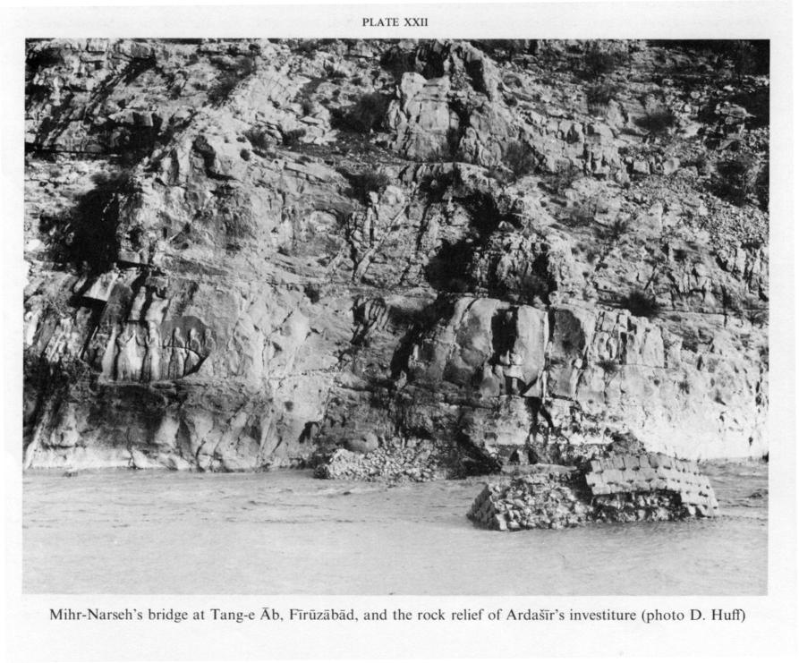
Qalʿa-ye Doḵtar, obviously Ardašīr’s first residence, built at the same time as the round city, is a palace of royal dimensions in an extensive fortification on top of a mountain plateau in a bend of the Tang-āb which dominates the main access to the plain (Plate I). The main palace rooms were arranged in a round donjon, standing in the main fortification line as another architectural symbol. The nearly inaccessible site, clearly chosen for its strategic qualities, coupled with cracks, which may have appeared before the building was finished and were due to the innovative type of vaulting, obviously led to the early abandonment of this castle and to the construction of the larger palace at a spring lake near the outlet of the gorge, erroneously called Ātaškada today. The structurally less ambitious and more solid building clearly proves this palace to be the later one; the lack of fortifications and its considerably more monumental layout indicates that it was built when Ardašīr had established his supremacy and military considerations were no longer necessary. Both palaces show the same architectural program although in differing arrangements: ayvān and square domed halls, 14 m wide, as royal audience halls; barrel-vaulted rectangular halls around a courtyard, probably for purposes of royal court-life; upstairs rooms as private living areas (Huff, 1972; idem, 1994). The Tang-āb gorge, blocked by a defensive wall north of Qalʿa-ye Doḵtar, contains the two rock reliefs of Ardašīr and the ruins of a bridge attributed to the 5th-century official Mehr-Narseh by a Pahlavi inscription (Henning; see BRIDGES i. PLATE XXII). Another early Sasanian bridge, rebuilt later, crossed the river immediately east of the round city. The date of an intervening third bridge is uncertain. A number of smaller fortifications, like Tall-e Ḵeżr, Tall-e Naqqāra-ḵāna, and Qalāt-e Ḥasanābād, show traces of Sasanian occupation, but some of them may be older (Huff, 1974). The piers of a čahārṭāq near Dawlatābād may indicate a fire temple of Sasanian or early Islamic date (Vanden Berghe, p. 166).
Although remaining a famous town and district into early Islamic times, Ardašīr’s residence had already lost its rank as the Sasanian capital when his son Šāpūr built his residence of Bīšāpūr 300 km to the west. Late Sasanian coins from Qalʿa-ye Doḵtar prove its importance as one of the last strongholds against the Arab invaders (Huff, 1978, p. 140). Fīrūzābād was favored by the Buyids, who may have carried out construction work at the great palace. Medieval chronicles compare the town with the three most beautiful places of the Islamic world (Schwarz, Iran, pp. 57-58.) and especially praise its roses, rose-water, and other essences. However, there are few noteworthy Islamic monuments. The mountain fortress of Qalʿa-ye Sohrāb (Sahāra in Ebn al-Balḵī, p. 158; tr., p. 75) was built by the Masʿūdī tribe of the Šabānkāra in the 11th century. The small castle of Naqqāra-ḵāna or Qalʿa-ye Pesar in the Tang-āb gorge north of Qalʿa-ye Doḵtar, and the traces of the eight-cornered, star-shaped Tell-e Qalʿa in the eastern exit of the plain, have early Islamic pottery. The important ruin of Emāmzāda Sayyed Dāwūd at Ḵerḵa seems to belong to the 12th-13th century; the abandoned but well preserved emāmzāda near Dawlatābād to the Safavid period. There are a number of high quality tomb-stones in the round city and in the plain, and a boulder with two Kufic inscriptions between the two reliefs in the Tang-āb riverbed. Surface pottery finds suggest that the round city was abandoned after the 14th century C.E. The modern town has grown up at the outskirts of the Sasanian enclosure wall on the plain. There is an 18-19th century gate to the governor’s palace-garden, exactly at the eastern corner of the twenty-sided polygon of the Sasanian master plan.
Bibliography
(for cited works not given in detail, see “Short References”):
Ebn al-Balḵī, Fārs-nāma, tr. G. Le Strange as Description of the Province of Fars, London, 1912.
E. Flandin and P. Coste, Voyage en Perse, Paris, 1834-54, I, pls. 34-44; V, pp. 36-45.
R. Ghirshman, “Firouzabad,” Bulletin de l’institut français d’archéologie orientale du Caire 46, 1947, pp. 1-28.
W. B. Henning, “The Inscription of Firuzabad,” Asia Major, N.S. 4, 1954, pp. 98-102.
E. Herzfeld, “Reisebericht,” ZDMG, N.S. 5, 1926, pp. 225-84.
D. Huff, “Zur Rekonstruktion des Turmes von Firuzabad,” Istanbuler Mitteilungen 19/20, 1969/70, pp. 319-38.
Idem, “Qal’a-ye Dukhtar bei Firuzabad,” AMI, N.S. 4, 1971, pp. 127-71.
Idem, “Der Takht-i Nishin in Firuzabad,” Archäologischer Anzeiger, 1972, pp. 517-40.
Idem, “An Archaeological Survey in the Area of Firuzabad, Fars,” Proceedings of the 2nd Annual Symposium on Archaeological Research in Iran 1973, Tehran, 1974, pp. 155-79.
Idem, “Fīrūzābād,” in Y. Kīānī, ed., Šahrhā-ye Īrān II, Tehran, 1366 Š./1987, pp. 75-117.
Idem, “Sassanidische architektuur,” in Hofkunst van de Sassanieden, Brussels, 1993, pp. 45-61; Fr. tr. in Splendeur des Sassanides, Brussels, 1993, pp. 45-61 (with several errors).
Idem, “Traditionen iranischer Palastarchitektur,” in Rezeption in der islamischen Kunst, Beiruter Texte und Studien 52, Stuttgart, 1998, pp. 137-56.
Idem and Ph. Gignoux, “Ausgrabungen auf Qal’a-ye Dukhtar bei Firuzabad 1976,” AMI 11, 1978, pp. 117-50.
Th. Nöldeke, tr., Geschichte des Artachšîr-i Pâpakân, Göttingen, 1879.
A. Stein, “An Archaeological Tour in the Ancient Persis,” Iraq 3, 1936, pp. 113-230.
L. Vanden Berghe, “Récentes décourvertes de monuments sassanides dans le Fars,” Iranica Antiqua 1, 1961, pp. 163-98.
Yāqūt, Boldān, part. tr. C. Barbier de Meynard as Dictionnaire de la Perse, Paris, 1861.