


KASHAN
v. Architecture and Urban Design
This sub-entry is divided into four sections:
The city of Kashan, similar to other older Iranian cities, preserved its traditional architectural features and urban design into the early 20th century. This traditional arrangement, which formed during the Saljuq and Safavid periods and continued through the Qajar era, drastically changed in the Pahlavi period and, more specifically, during the latter half of the 20th century (Narāqi, 1969).
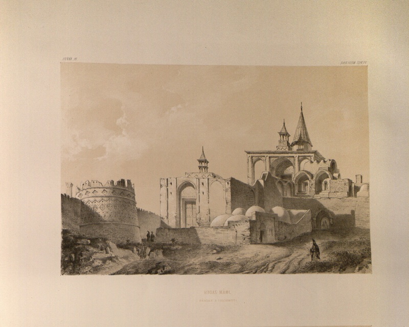
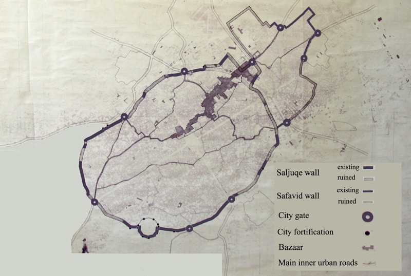
Urban design of the pre-modern town. The old town of Kashan was surrounded by walls that were in turn enclosed by, and via gates connected to, the cultivated lands in its immediate vicinity (see Figure 1). Within the city walls, the arrangement of the town followed the pattern of Iranian cities in the medieval Islamic era, which consisted of four urban spaces: the citadel (see arg), the bazaar, the mosques and madrasas (see education iv-vi), and the residential quarters (maḥallas; for the organization of Iranian urban life during the medieval Islamic period, see Ashraf, 1974, pp. 7-49). The Jalāli Citadel, which was constructed under the Saljuqid sultan Jalāl-al-Din Malekšāh, did not survive during the 18th-19th centuries, yet the city preserved its gates, fortified walls, and towers for much of the 19th century. During the Safavid period, at the height of its prosperity, Kashan boasted of five well-maintained gates: the Dawlat Gate (adjacent to the Royal Palace) towards the east; the Fin Gate, towards the town of the same name (see bāḡ-e fin) in the west; the Malek bād Gate (near Malek Palace) towards the northwest; the Isfahan Gate, towards the southeast (Figure 2); and the Qom Gate towards the northeast (Chardin, pp. 430-31). During the Zand period, the district governor, ʿAbd-al-Razzāq Khan, who had restored the town’s public spaces which had been seriously damaged after the severe earthquake of 1779, constructed two more gates for the town: the ʿAṭāʾ Gate on the southeastern section of the town’s fortification and Latḥar Gate, located between Jalāli Citadel Square (Maydān-e Qalʿa-ye Jalāli) and Isfahan Gate (Kalāntar Żarrābi, pp. 207-8; Narāqi, 1969, pp. 155-57; see Figures 2 and 3).
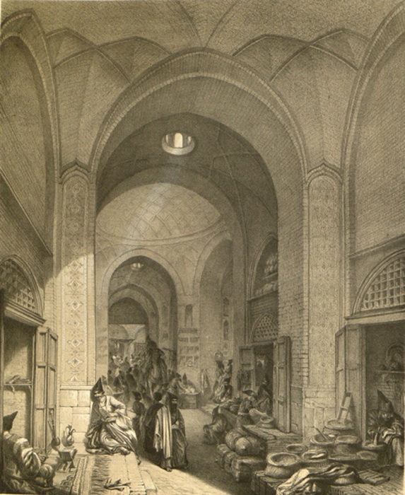
The bazaar was located in the central section of the town, while the urban quarters lay on two wings of the bazaar with mosques in major sections and the regional roads directed towards the bazaar caravansaries (Figure 3).
The bazaar of Kashan, which prospered during the Safavid era with a large number of craftsmen and transactions in large amounts of commodities, declined substantially during the Qajar period (see Ashraf, 1970). The introduction of European fabrics, rearrangement of foreign trade, and relocation of production from textiles to carpet weaving, which developed in the spaces outside of the bazaar in the Qajar era, led to the decline of industry and trade in the traditional marketplace. Nevertheless, the bazaar continued its commercial activities and extended towards the northeast, while the town incorporated the Pošt-e Mashad quarter within its eastern boundaries (see Figure 4). New additions to the bazaar included the Timča-ye Amin-al-Dawla caravansary, two prosperous madrasas, and a mosque (see 3, below).
The main features of the indigenous architecture and urban design of Kashan prior to the 1920s can be described as exhibiting a harmonious relationship with the natural, arid environment by (1) orienting the alleyways to direct favorable winds through the city, providing shade by creating narrow passages, and (2) conserving water by means of subterranean structures and transporting it through underground aqueducts (see kāriz) to public water tanks/ cisterns (see āb-anbār). These circulation networks, with covered alleyways inside and outside the bazaar, afforded residents ease of passage during the summer heat and winter cold. Other major characteristics included use of mud as well as baked brick in the construction of arches, vaults, and domes in all buildings; organized divisions of the city into residential quarters serviced by public facilities such as water cisterns, public laundries, baths, mosques, schools, neighborhood bazaars, and connecting streets and alleyways; and natural growth of the city over time with a harmonious continuity utilizing indigenous architectural and city planning principles.
Urban design in transition. With the introduction of the automobile and construction of vehicular roads and streets, Kashan began to grow without the hitherto strong attention to its historical character and indigenous way of life. The increasing communication with Tehran led to the removal of the northeast part of the city wall around 1920. Later, during the period 1925-35 the city witnessed the establishment of the Department of Records, a branch of the new national bank (Bank-e Melli), the first textile factory, and the construction of a road on the north and west side of the city which connected Kashan to the historical town of Fin. Furthermore, during 1935-45, due to the central government’s policy to increase means of transportation, the vehicular road between Kashan and Tehran was constructed, which in turn increased the rate of development along the two roads to Fin and Tehran. During this same period, the railroad reached the city, and a station was built on the east side of Kashan. As a result of this progress in the means of transportation, the surrounding agricultural villages of Mehzāb bād, Yaḥyā bād, and Jamāl bād were incorporated within the city boundaries.
In the next decade, 1945-55, the first vehicular city square incorporating a green park was built at the crossing of two new streets, which were aligned with the cardinal directions of the compass. In the following decades two of the villages (Ṣafi bād and Lathar) were joined into Greater Kashan, more textile factories were built in the hinterlands, and more branches of multiple new banks were established in the city. Around 1951, major vehicular avenues were built running through different neighborhoods, which broke the continuity of the fabric of the indigenous architecture of these areas. At the same time, communications with the surrounding towns and villages elevated Kashan to a central position in the sub-province. In the last 70 years (1940-2010), new settlements have emerged around the major roads leading out of the city with such rapidity that they have engulfed the historical city, giving the appearance of dispersed settlements.
The rise of incoherent urban design: 1960-2010. In spite of the construction of the inter-urban streets parallel to the cardinal directions of north-south and east-west, the old city mostly preserved its historical features and identity until the 1950s; the bazaar, major old buildings, caravansaries, historical open spaces, and the particular style of residential architecture, as well as the production of silk fabrics, carpets, and copper vessels, were all in evidence. The two major historical sites of Sialk Mound (5th and 6th century BCE) and the Garden of Fin (3 and 6 kilometers to the west, respectively) were absorbed into the territory of Greater Kashan. In the course of four decades from 1960, as a result of unprecedented development and construction of ring roads and expressways, the villages of Ḵoroq, Ṣāleḥ bād, Lathar, Ḥasan bād, Fin, and the town of Rāvand were also added to the city’s jurisdiction. The unchecked building practices of poor-quality developments within the city and its environs turned the city into a hodgepodge collection of low-income neighborhoods—provincial and newly constructed buildings which have enveloped and concealed the old city to such an extent that the historical value of its architecture and city planning is no longer apparent.
Urban planning. The first attempt at a city planning scheme for urban development was started in 1975, which lay down a plan for the controlled zoning of different functions and for establishing networks of streets and areas for land development, and in 1980 it clarified the path of future development for the city. However, rapid turnover in the management of the city administration, and the lengthy and cumbersome process of the passage of the urban development plan through the legislature, have impeded such plans from fruition.
During the 1990s, the rapid destruction of the historical quarter and the city officials’ indifference to it led to the formation of two separate plans for restoration. Unfortunately, these plans were not able to succeed in preserving the old fabric of the historical city and soon were forgotten. The increase of the city’s area from 660 to 8,680 hectares in thirty years (1975-2005; Table 1) reflects the lack of proper planning and management.
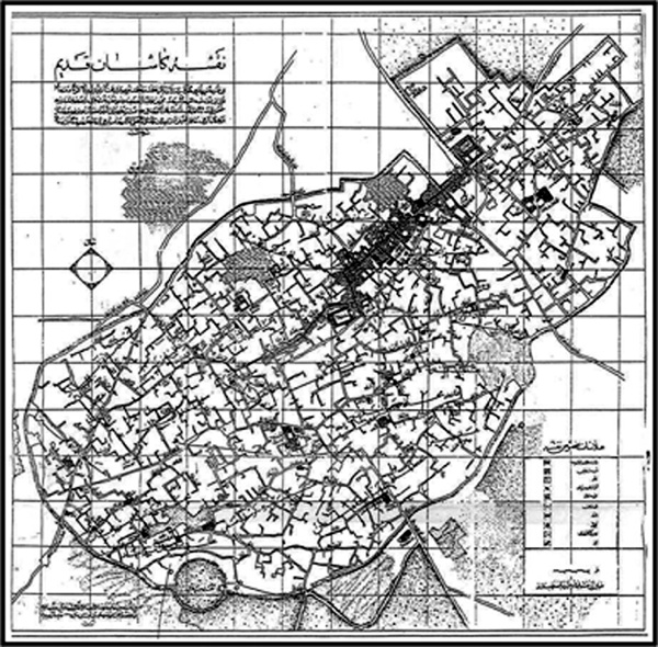
In 2005 a comprehensive and detailed plan for Greater Kashan was commissioned and prepared, but it has yet to be approved by the city planning authorities. In the absence of a comprehensive plan, the agricultural land has been parceled into small plots for housing construction without allocating open spaces, sidewalks, zoning for industry, infrastructure, and utilities. Currently undeveloped land is being sold for commercial/retail and residential developments. Circulation is provided only for vehicular access with disregard for pedestrian needs and proper and harmonious relationship with nature and the cultural heritage of the city. The original inhabitants of the old city quarters have either passed away or moved outside of the old quarters. The majority of the current inhabitants of the old city since the 1980s have been Afghan immigrants, who live in unfavorable conditions. The greater part of the city now is comprised of vehicular roads and newly built residential and non-residential buildings, and the historical elements of the city have been reduced to miniscule remnants. Among recognizable traces of the old fabric of the city there are Sang Square (Maydān-e Sang or Maydān-e Fayż) and the main city bazaar, which in the 1960s was surrounded and isolated by newly built streets while itself remaining relatively untouched. In the 1990s a newly constructed street parallel to the main backbone of the bazaar threatened the survival of this unique feature of the old city, since many adjoining neighborhoods had been destroyed in the process. The Cultural Heritage Foundation has registered a number of the buildings in an effort to save them from destruction. According to the registry, some 300 houses, 36 streets/alleyways, and more than 40 neighborhoods have been recognized as sites of historical importance (see Figure 5).
Throughout the 8,680-hectare city district, there is a multiplicity of the historical fabric of the old city, provincial elements, and organized and structured areas independently dispersed within the city boundaries. As of 2005, more than 30 percent of the land within the city remains undeveloped and barren. The city continues to grow within the framework of providing vehicular access and land for development. The character of architecture is moving toward boxlike, low-quality buildings with the use of improper materials and a disregard for harmony.
In city planning vernacular, Kashan was referred to as a ‘historical town’ prior to the 1950s. After the rapid growth of the city without incorporation of its indigenous heritage, it has been downgraded to one of ‘historical heritage.’ Since 2000, according to the legal parlance of the city planning authority, the original 660 hectares of the old city have been redefined as ‘eroded context.’