

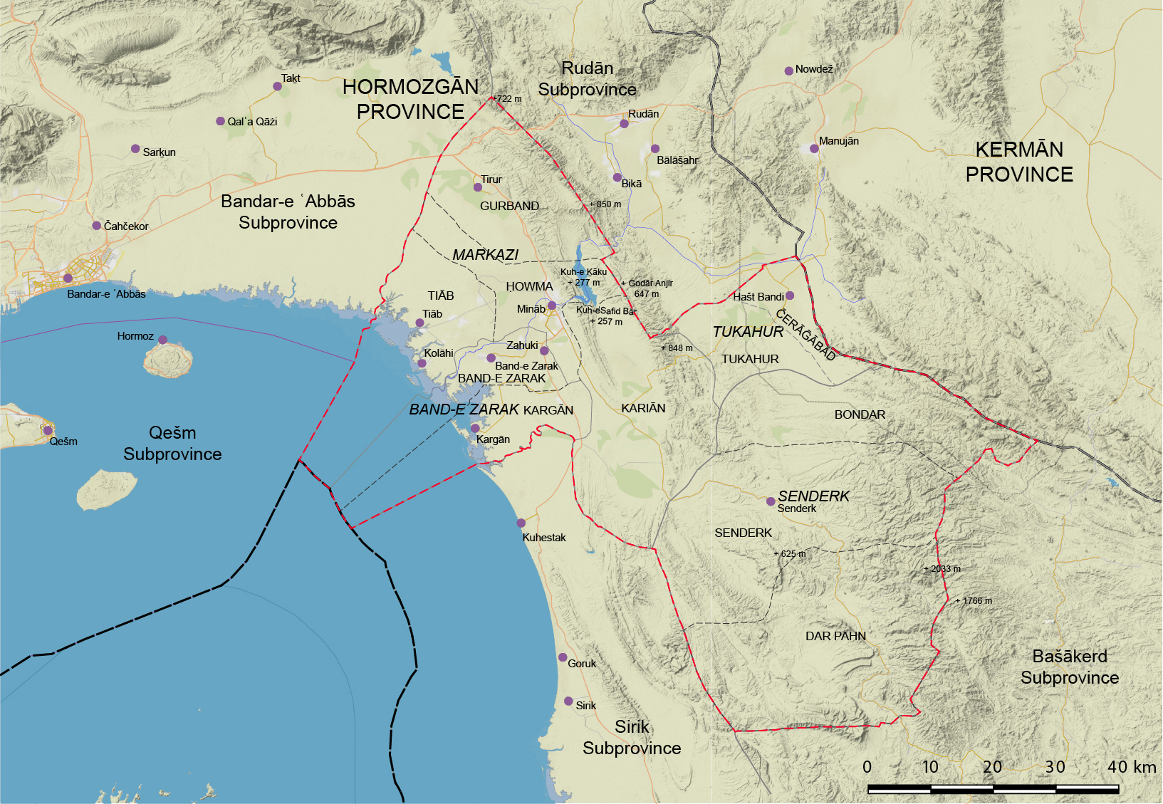
MINĀB, city and capital of Mināb subprovince (šahrestān) in Hormozgān province (ostān); the city is located at lat 27° 7′ 51′′ N, long 57° 5′ 13′′ E (Figure 1).
The name Mināb (also Minao, Minau, Minav, Minaw, Minnow in early European sources; Berghaus, p. 48; Lorimer, p. 1226) is derived from Qalʿa-ye Minā (Minā castle), one of seven castles mentioned in the Hormuz (q.v.) region (Yazdi, I, p. 578; see also Ḥakim, pp. 820-21). The town is situated about 25 km inland from the northern shore of the Sea of Oman (q.v.), 16 meters above sea level.
Mināb subprovince is located on the tip of the arch parallel to the Strait of Hormuz, and is bounded on the northeast by Manujān subprovince in the province of Kerman (q.v.), on the north by Rudān, on the west by Bandar-e ʿAbbās (q.v.), to the southwest by Sirik, and to the southeast by Bašākerd (q.v.) subprovinces of Hormozgān (q.v.) province. Its altitude rises from sea level at the coast to 1,500 meters in the highlands. North and northeastern parts of Mināb are mountainous, and central and western parts form a plain with an area of about 120 km2. The Godār Anjir, Kuh-e Safid Bār, and Kuh-e Ḵāku form the mountainous heights of Mināb. The river Mināb, 240 km long, rises in the Sarvestān heights, flows across the city of Mināb, and discharges into the Sea of Oman. There are also five minor seasonal rivers in the subprovince.
The city of Mināb has a warm, humid climate, with average temperatures ranging from 6° C in winter to 48° C in summer; the average annual rainfall is 253 mm (Sāzmān-e joḡrāfiāʾi, p. 15) which is, on average, 25 mm more than that received on the coast at Bandar-e ʿAbbās (Carls, p. 31). This accounts for the fact that, when Lieutenant Whitelock, an officer of the Indian Navy, visited the region sometime between the years 1821 and 1829, “during the hot months many of the better classes from Bandar-ʿAbbás and Kishm resort hither, when, in addition to its superior climate, they enjoy the luxury which its light and pure water affords” (Whitelock, p. 174; cf. MacGregor, p. 332). Indeed, Ernest A. Floyer, who visited Mināb in 1876, called it “the sylvan retreat of the merchants of the Bandar [ʿAbbās],” which “during the date harvest draws to itself all the able-bodied men of the country for a hundred miles round” (Floyer, p. 140). Flora consists of ḥarrā trees (probably Avicennia marina or mangrove) covering an area of some 20 km², gaz (q.v.; tamarisk), gavan (Astragalus gummifer), almonds, and tāḡ (saxual). Small quantities of chromate, sulfuric acid, magnesium, and iron-ore have been identified but not yet extracted (Afšār-Sistāni, p. 286; Sāzmān-e joḡrāfiāʾi, pp. 6-7, 23-25, 32). According to John Macdonald Kinneir (q.v.), who visited the area in 1810, “The country for forty-five miles round Minab is covered with villages, abounds in dates, and supplies all the neighbouring country with grain. Forage is so plentiful, that the cattle of the adjoining districts are sent in great numbers to feed there during the hot season” (Kinneir, p. 201). At this time it was tax-farmed by the Imam of Muscat (Kinneir, p. 201). Lewis Pelly, who noted a later treaty of lease, dating to 1856, for the Bandar-e ʿAbbās district, including “Minao,” for 16,000 tomans, or about £8,000 pounds, for a term of twenty years, observed that, “It is assumed that the revenue from dates collected at Minao covers the 16,000 tomans payable to the Shah,” while a further 13,000 tomans in outright income were cleared by subletting “the revenue and customs of these districts to a British Indian subject of the Khoja (q.v.) caste for about 25,000 tomans per annum” (Pelly, p. 247).
Although the first mention of Mināb in a Persian source appears to be in Moḥammad-Jaʿfar Ḥosayni Ḵvormuji’s (1810-84) 19th century Āṯār-e jaʿfari, under “Bandar ʿAbbās and its dependencies” (p. 160), human occupation in the region stretches back into deep prehistory. For example, stone tools of Middle Palaeolithic date, circa 200,000-250,000 BP, were identified at Mināb in the 1970s (Biglari and Shidrang, p. 163); ceramics of third millennium BCE date have been found in excavations at Tom-e Mārun, in Komiz, a village located in the Rudān subprovince (Amirhajloo, Ghorbani and Alimoradi, p. 42); Arsacid-Sasanian painted pottery is attested around Mināb (Sajjadi, p. 32); and early mediaeval occupation is extensive, with a high representation of East Asian ceramics attesting to long distance commercial ties with China and southeast Asia (Stein, p. 184; Morgan; Carls, pp. 83-112). All of this archaeological evidence indicates clearly that, while Mināb’s expansion may have post-dated the transfer of the capital of the kingdom of Hormuz to Jarūn (Hormuz) island (Floor, 2011a, p. 276) from the mainland locale often referred to as “Old Hormuz” (possibly the site K-103 identified during a survey in 1969-70 by Andrew Williamson; see Morgan, p. 67; perhaps identical to the site of Kalātun described by Sir Aurel Stein [q.v.] in 1937; see Stein, p. 184), Mināb and its environs had been settled for millennia. The fort there is attested in 1318 when the king of Hormuz took refuge “in the fortress of Minab, which name means ‘the Blue Fort,’” according to Turān Shah (Semler, p. 642), perhaps “from some blue-tiled building, or the water, therein or thereabouts” (Sinclair note to Teixeira, p. 171, n. 1). In 1397, Mināb fell to Tamerlane’s son, Solṭān-Moḥammad (Yazdi, I, p. 578; Mirḵᵛānd, VI, p. 1075; see also Ḥakim, pp. 820-21).
Following the Portuguese annexation of Hormuz, “Minao” appears as one of three “external territories” (birunāt) administered by a vizier in a revenue list from 1515 (Aubin, p. 107; Floor, 2011b, p. 91). Mināb served as a sanctuary for Portuguese and Iranian families when Hormuz was attacked by the Turkish commander Piri Reʾis, and an Ottoman fleet in 1552 (Floor, 2011a, p. 276). Mināb resisted Safavid (q.v.) control until 1602 when it was occupied by the Persians (Loureiro, p. 261; Floor, 2011a, p. 276). En route from Isfahan to Hormuz in 1621, Pietro Della Valle (q.v.) and his wife, Maʿani, visited Mināb, where she died (Chick, p. 290; Brancaforte, p. 194). Shortly thereafter, Edward Monox and Thomas Rastell of the British East India Company (q.v.) negotiated an alliance with Emāmqoli Khan, the governor-general of Fārs, at Mināb, whereby they were to act in concert with the forces of Shah ʿAbbās I (q.v., r. 1588-1629) to dislodge the Portuguese from Hormuz and Qeshm island (q.v.), sharing in the anticipated spoils (Chick, p. 259). By this time the mayor (kalāntar, q.v.) of Mināb, Shaikh Sayfi, was a staunch ally of the Safavid crown (Floor, 2011a, pp. 276-77; for a list of Mināb’s mayors from 1552 to 1892 see Floor, 2011a, p. 279).
In the later 17th century, loyal Minābi troops participated in Safavid campaigns against Baluchistan (q.v.), but the oppression of Nāṣer ʿAli Khan, governor of Bandar-e ʿAbbās, prompted the inhabitants of both Mināb and Bandar-e ʿAbbās to send delegations to the Safavid court complaining of his misrule (Slot, p. 206; Floor, 2011a, p. 277). When the Afghans overthrew the Safavid dynasty in 1722, the residents of Mināb appealed to their mayor, Mir ʿAbd-Allāh, for protection, and he in turn applied, unsuccessfully, to the Dutch for military aid in order to defend the fort of Mināb. In 1725, however, Mir ʿAbd-Allāh himself led a force of 500 men to help defend Bandar-e ʿAbbās. Two years later, pro-Safavid authorities continued to hold Qeshm and Hormuz, but Afghan forces entered Bandar-e ʿAbbās and Mināb (Slot, p. 263). Before the year 1729 was out, however, Amir Mehr-ʿAli entered both towns in the name of Ṭahmāspqoli Khan, the governor of Kerman (Slot, p. 272). Despite appealing to the Dutch and English authorities, little help was forthcoming. During the final weeks of Afghan rule, the mayor of Mināb, Shaikh ʿAbd-al-Ṣafi, sought accurate information on the state of play from the Dutch at Bandar-e ʿAbbās (Floor, 2009, p. 104). The Dutch were generally supportive of Nāder Shah (q.v.) but incurred a significant debt at Mināb for their trouble, which they found difficult to get repaid. In 1744, the economy of Mināb suffered greatly at the hands of Moḥammad-Bāqer Beg Lāri who despoiled the area, bringing both local agriculture and trade to an abrupt halt (Floor, 2009, p. 172). In the same year, in the wake of the mutinies under Moḥammad-Taqi Khan Širāzi, the commander of Fārs province, Nāder Shah temporarily gave the Dutch authority to rule over Bandar-e ʿAbbās and Mināb in his name (Slot, p. 316).
According to a Dutch report in 1756, “the Persian coast begins with Minauw. Its inhabitants live from agriculture and not from navigation (having only a few flat-bottomed vessels). Moreover, as they are completely Persian subjects one can not count them among the navigators of this Gulf” (Floor, 1979, p. 167). Seventeenth and eighteenth century maps (see GEOGRAPHY iv. Cartography of Persia) of the Persian Gulf (q.v.) render the name of Mināb variously, e.g., as “Mina” on maps by Robert Morden (1676), Pierre Mortier (ca. 1700), Hermann Moll (1710), Nicolas de Fer and Paolo Petrini (1717), John Senex (1720), Johann Baptist Hommann (1723/4), Guillaume Delisle (1724), Thomas Bakewell (1729), Isaak Tirion (ca. 1734), Matthäus Seutter (ca. 1735), Reiner and Josua Ottens (1730s-1740s), Emmanuel Bowen (ca. 1744) and Jean-Baptiste Bourguignon d’Anville (1758, publ. 1776), and “Minau” on Carsten Niebuhr’s map of 1765 (Couto, Bacqué-Grammont, and Taleghani, pp. 211, 217, 221, 279, 285, 295, 327, 347, 353, 359, 361, 397, 407).
Under the Zand dynasty (q.v.), Mināb continued to find itself in the crossfire, this time between Mollā ʿAli Ḥosayn of Bandar-e ʿAbbās and Nāṣer Khan of Lār, not to mention suffering ongoing depredation at the hands of Baluchi raiders (Floor, 2011a, p. 278). Around 1794, the Omanis gained control of Mināb, a situation that persisted, though not without conflict, for much of the 19th century (Floor, 2011a, pp. 279-80). In 1853/54 the merchant Moḥammad Raḥim Khan Širāzi became governor of the district that included Mināb, Bandar-e ʿAbbās, and Šamil (Fasā’i, p. 306). In 1855/56, a retreating Omani force that was being ousted from Bandar-e ʿAbbās by ʿAbd-al-Bāqi Mirzā captured Aḥmad Shah Minābi, the mayor of Mināb, and took him to Qešm (Fasā’i, p. 312). Shortly thereafter, the Imam of Muscat was confirmed in the governorship of Bandar-e ʿAbbās and its dependencies, including Šamil and Mināb, but in 1867/68 this was revoked and conferred upon Mahdiqoli Mirzā, governor of Lārestān (Fasā’i, p. 362). Five years later, the office was given to Aḥmad Šāh Minābi (Fasā’i, p. 377). Around 1873-88, Moḥammad Ebrāhim Kāzeruni speaks of Minā district (boluk), villages (qorāʾ), and port (bandar) (Kāzeruni, p. 125). Mināb belonged historically to the province of Kerman (see KERMAN i. Geography). In the late 19th century, Mināb had a “well supplied” bazaar outside of the fort (Constable and Stiffe, p. 207).
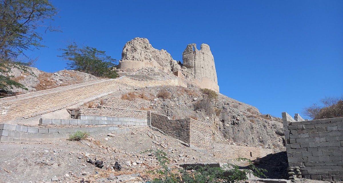
As this rapid historical survey has shown, throughout Mināb’s history its fort was a focal point (Figure 2). John M. Kinneir described it as “situated partly on a hill,” noting that it was “divided into the upper, centre, and lower forts” (Kinneir p. 201). According to Whitelock, it had “round towers at the corners, in which there are a few old guns, bearing inscriptions in Portuguese and Dutch. A draw-bridge, thrown across a moat, leads to a gate thickly studded with iron knobs and spikes on the south-western side” (Whitelock, p. 173; cf. MacGregor, p. 333). When Whitelock visited “Minaw” the walls of the fort were “strong,” the fort was “generally in good condition,” and its garrison consisted of “about 100 men, well appointed, who are obliged to be constantly on the alert, in consequence of the numerous marauding bands who rob and plunder the country” (Whitelock, p. 173; MacGregor, p. 333). By the late 19th century, the fort, built of sun dried mud brick, although “large and imposing, being built up the hill enclosing a space of 200 to 300 yards square,” and a “scarped ditch” on its southern side, was “very dilapidated” (Constable and Stiffe, p. 207).
Mināb’s economy is currently based on agriculture, fishing, and handicrafts. In the late 1990s, Mināb ranked as Iran’s second largest date palm oasis (Carls, p. 18). Currently it ranks first in the quantity of date palms in Iran (for the vocabulary of date palms in Minābi, see Barbera, 2006, pp. 321-34). Mangoes, bananas, lemons, wheat, and barley are its other agricultural products. Its handicrafts consist of gold embroidery, mat weaving, pottery, and various kinds of traditional mattresses. Food and lemon juice production are among the few modern industries in Mināb (ʿAbd-Allāhi, pp. 34-35; Sāzmān-e joḡrāfiāʾi, pp. 31-32, 44; Afšār-Sistāni, p. 287). The climatic conditions of Mināb are such that summer produce arrives between 40 to 50 days earlier than the national average (Afšār-Sistāni, p. 286), which is a remarkable economic advantage for Mināb. In the 1870s, high-quality gunpowder was manufactured at Mināb (Floyer, p. 31).
At the time of the 2016 national census, the population of the city of Mināb was 70,790 and that of Mināb subprovince was 259,221. As of 2022, the subprovince is divided into four districts (baḵš): Markazi (Mināb), Band-e Zarak, Senderk, and Tukahur. Its main ports are Tiāb, Kolāhi, and Kargān, each opening onto a small bay, locally called ḵawr (Afšār-Sistāni, p. 268; cf. the estuaries called ḵor, ḵowr, or ḵawr in Ḵuzestan, on which see KARUN RIVER i. Geography and Hydrology). Most of the population is Shiʿi, with a Sunni minority (Sāzmān-e joḡrāfiāʾi, p. 30).
The native dialect of Mināb (Skjærvø, pp. 113-28; Barbera, 2005; 2006) is closely related to the vernaculars spoken to its north in Manujān, Kahnuj, Rudbār, and Jiroft (see BAŠKARDI), which are, along with Mināb, districts historically belonging to the garmsir, warm zones (see GARMSĪR AND SARDSĪR), of Kerman province. These varieties form a dialect continuum that has been designated as the Garmsiri language type commensurate with their climatic arrangement (see KERMAN xvi. Languages).
(This article replaces an earlier entry by Jamšid Ṣadāqatḵiš and EIr.)
Bibliography
M. ʿAbd-Allāhi, “Az Bandar-e Jarun tā Bandar-e ʿAbbās,” Āmār-nāma, Tehran, 1998.
L. W. Adamec, Historical Gazetteer of Iran V: Zahidan and Southeastern Iran, Graz, 1976, pp. 304-17.
I. Afšār-Sistāni, Šenāḵt-e Ostān-e Hormozgān: majmuʿa-i az tāriḵ, joḡrāfiā, āṯār-e bāstāni, jāḏabahā-ye jahāngardi, Tehran, 1999.
S. Amirhajloo, H. R. Ghorbani and H. Alimoradi, “An Ethno-Archaeological Study on the Thin-Walled Ceramics based on the Production Techniques of the Contemporary ‘Jahleh’ Wares in Minab, Hormozgan, Iran,” Iranian Journal of Archaeological Studies 10/1, 2020, pp. 31-46.
J. Aubin, “Le Royaume d’Ormuz au début du XVIe siècle,” Mare Luso-Indicum: Études et documents sure l’histoire de l’Océan Indien et des pays riverains à l’époque de la domination portugaise 2, 1973, pp. 77-179.
G. Barbera, “Lingua e cultura a Minâb, Iran sudorientale: profilo grammaticale, testi e vocabolario,” Ph.D. diss. Università degli studi di Napoli L’Orientale, Naples, 2005.
Idem, “The Palm in Minâb,” in A. Panaino and R. Zipoli, eds., Proceedings of the 5th Conference of the Societas Iranologica Europæa held in Ravenna, 6-11 October 2003, vol. II: Classical & Contemporary Iranian Studies, Milan, 2006, pp. 317-34.
H. K. W. Berghaus, Geo-hydrographisches Memoir zur Erklärung und Erlaüterung der reduzirten Karte vom Persischen Golf, Gotha, 1832.
F. Biglari and S. Shidrang, “The Lower Paleolithic Occupation of Iran,” Near Eastern Archaeology 69/3-4, 2006, pp. 160-68.
E. C. Brancaforte, “The Italian Connection: Pietro Della Valle’s Account of the Fall of Hormuz (1622),” in D. Couto and R.M. Loureiro, eds., Revisiting Hormuz: Portuguese Interactions in the Persian Gulf Region in the Early Modern Period, Wiesbaden, 2008, pp. 191-204.
H.-G. S. Carls, “Das Hochmittelalterliche Seefernhandelszentrum von Hormoz,” Ph.D. diss. Julius-Maximilians-Universität Würzburg, Würzburg, 1999.
H. Chick, A Chronicle of the Carmelites in Persia: The Safavids and the Papal Mission of the 17th and 18th Centuries, I, London and New York, 2012.
C. G. Constable and A.W. Stiffe, The Persian Gulf Pilot: Comprising the Persian Gulf, Gulf of Omán; and Makrán Coast, London, 1883; 3rd ed., 1890.
D. Couto, J.-L. Bacqué-Grammont, and M. Taleghani, Atlas historique du Golfe Persique (XVIe-XVIIIe siècles) / Historical Atlas of the Persian Gulf (Sixteenth to Eighteenth Centuries), Turnhout, 2006.
A. Eqtedāri, Āṯār-e šahrhā-ye bāstāni-e sawāḥel wa jazāyer-e Ḵalij-e Fārs wa Daryā-ye ʿOmān, Tehran, 1969.
Ḥ. Fasā’i, Fārs-nāma, tr. H. Busse, as Fārsnāma-ye Nāṣeri: History of Persia under Qājār rule, New York, 1972.
W. M. Floor, “A Description of the Persian Gulf and Its Inhabitants in 1756,” Persica 8, 1979, pp. 163-86.
Idem, The Rise and Fall of Nader Shah: Dutch East India Company Reports, 1730-1747, Washington, D.C., 2009.
Idem, The Persian Gulf, Bandar Abbas: The Natural Trade Gateway of Southeast Iran, Washington, D.C., 2011a.
Idem, “Two Revenue Lists from Hormuz (1515, 1543),” in R. Mathee and J. Flores, eds., Portugal, the Persian Gulf and Safavid Persia, Louvain, 2011b, pp. 81-97.
E. A. Floyer, Unexplored Balūchistan: A Survey, with Observations Astronomical, Geographical, Botanical, etc., of a route through Mekran, Bashkurd, Persia, Kurdistan, and Turkey, London, 1882.
Moḥammad-Taqi Khan Ḥakim, Ganj-e
dāneš: joḡrāfiā-ye tāriḵi-e šahrhā-ye Irān, eds. M.-ʿA. Ṣawti and J. Kiānfar, Tehran, 1987.
Moḥammad-Jaʿfar Ḥosayni Ḵᵛormuji, Āṯār-e jaʿfari yā fārs-nāma, Tehran, 1860.
M.-E. Kāzeruni, Tāriḵ-e banāder wa
jazāyer-e Ḵalij-e Fārs, Tehran, 1988.
J. M. Kinneir, A Geographical Memoir of the Persian Empire, London, 1813.
J. G. Lorimer, Gazetteer of the Persian Gulf, ʿOman, and Central Arabia IIB: Geographical and Statistical, Calcutta, 1918.
R. M. Loureiro, “After the Fall of Hormuz: Naval Campaigns and Textual Battles,” in D. Couto and R. M. Loureiro, eds., Revisiting Hormuz: Portuguese Interactions in the Persian Gulf Region in the Early Modern Period, Wiesbaden, 2008, pp. 261-70.
C. M. MacGregor, Central Asia, Part IV: A Contribution Towards The Better Knowledge of The Topography, Ethnology, Resources, and History of Persia, Calcutta, 1871.
Moḥammad b. Sayyed Borhān-al-Din Ḵᵛāvandšāh Mirḵᵛānd, Rawżat al-ṣafā VI, ed. ʿA. Zaryāb, Tehran, 1994.
P. Morgan, “New Thoughts on Old Hormuz: Chinese Ceramics in the Hormuz Region in the Thirteenth and Fourteenth Centuries,” Iran 29, 1991, pp. 67-83.
L. Pelly, “Remarks on the Port of Lingah, the Island of Kishm, and the Port of Bunder Abbass, and Its Neighbourhood,” The Transactions of the Bombay Geographical Society 17, 1864, pp. 237-55.
J. R. Preece, Journey from Shiraz to Jashk, viâ Darab, Forg, and Minab, From
Supplementary Papers
of the Royal Geographical Society 1/3, 1885.
Ḥ.-ʿA. Razmārā, ed., Farhang-e joḡrāfiāʾi-e Irān: Kermān o Makrān, Tehran, 1953, pp. 404-5.
M. Sajjadi, “A Class of Sasanian Ceramics from Southeastern Iran,” Rivista di Archeologia 13, 1989, pp. 31-40.
Sāzmān-e joḡrāfiāʾi-e niruhā-ye mosallaḥ, Farhang-e joḡrāfiāʾi-e ābādihā-ye ostān-e Hormozgān, šahrestān-e Mināb, Tehran, 2004.
J. S. Semler, Uebersetzung der Algemeinen Welthistorie die in Engeland durch eine Geselschaft von Gelehrten ausgefertiget worden, XXII, Halle, 1761.
P. O. Skjærvø, “Notes on the Dialects of Minab and Hormoz,” Norwegian Journal of Linguistics
/Norsk Tidsskrift for Sprogvidenskap 29, 1975, pp. 113-28.
B. J. Slot, The Arabs of the Gulf, 1602-1784: An Alternative Approach to the Early History of the Arab Gulf states and the Arab Peoples of the Gulf, Mainly Based on Sources of the Dutch East India Company, Leidschendam, 1993.
M. A. Stein, Archaeological Reconnaissances in North-Western India and South-Eastern Īrān, London, 1937.
P. Teixeira, The Travels of Pedro Teixeira; with his “Kings of Harmuz,” and Extracts from his “Kings of Persia,” tr. W. F. Sinclair, London, 1902.
Lt. Whitelock, “Descriptive Sketch of the Islands and Coast Situated at the Entrance of the Persian Gulf,” The Journal of the Royal Geographical Society of London 8, 1838, pp. 170-84.
Šaraf-al-Din ʿAli Yazdi, Ẓafar-nāma: tāriḵ-e ʿomumi-ye mofaṣṣal-e Irān dar dawra-ye Teymuriān, ed. M. ʿAbbāsi, Tehran, 1957; repr. 1997.