


iv. THE HISTORICAL RECORD OF EARTHQUAKES IN PERSIA
Introduction. The Iranian plateau, characterized by active faulting, active folding, recent volcanic activities, and considerable elevation contrasts along the Alpine-Himalayan mountain belt, has been frequently struck by catastrophic earthquakes during recorded history. These earthquakes have resulted in great loss of life and, by rendering large numbers of people homeless and disrupting the agricultural and industrial bases of their lives, have wasted natural resources.
Archaeoseismicity. Large, destructive earthquakes are very infrequent. The dormant period between large-magnitude earthquakes on a particular fault or fault segment in Persia ranges from many centuries to millennia (Berberian, 1981, pp. 44-45; Ambraseys and Melville, 1982, pp. 158-62; Berberian et al., 1992, pp. 1728-31). The great length of the earthquake cycle for most active faults in Persia results in a paucity of historical (pre-1900) and instrumental (20th century) data from which to assess earthquake hazards or derive an understanding of the mechanism of faulting. Unlike instrumental and historical seismic records, the archaeological and geological records of earthquake activity extend many earthquake cycles into the past. Archaeological sites and historical monuments may yield direct or indirect evidence of earthquake activity. They may contain episodes of rebuilding or repairs following earthquakes.
Several archaeological sites and monuments have provided earthquake information on Persia: Sagzābād about the middle of the 3rd millennium B.C.E. (Negahbān, 1973, pp. 11-13; Berberian et al., 1993, pp. 100-102), Ak-Tapa of 4,000 B.C.E. (Golinsky, 1982, p. 519), Gowdīn-Tapa of 4,000-3,350 B.C.E. (Young, 1968, p. 160), Mārlīk of 3,000-2,000 B.C.E. (Negahbān, 1990, p. 146; Berberian et al., 1992, pp. 1728-31), Parthian Nesā of 10 B.C.E.-10 C.E. (Golinsky, 1982, p. 519), Kangāvar Anāhītā Temple of the 17th century B.C.E. and 224-642 C.E. (Kāmbaḵš-Fard, 1974, p. 47), Bīšāpūr city of 293-302 and 531-79 C.E., late 10th century (Sarfarāz, 1987, pp. 45, 56, 71, and personal communication, January 1994; Berberian, 1994, p. 221), Nīšāpūr of 1145 and 1270 (Wilkinson, 1975, pp. xxxv, xxxvi), and Masjed-e-Jāmeʿ of Qāen of 1066 (Nāderī, 1980, pp. 103-07 ). The decline of civilization in the following cities seems to have been partly, if not largely, due to large-magnitude earthquakes, some of which were associated with long surface faulting: Sagzābād, Mārlīk, Kūmeš (after the 856 earthquake), Zarang/Sīstān (around 734, 805, and 815 C.E.), Sīrāf (978 and 1008 C.E.; Ṭāherī), Nīšāpūr (1145, 1209, 1251, 1270, 1389, and 1405), and Jīzd (1336). (For more information, see Berberian, 1994, pp. 53-161.)
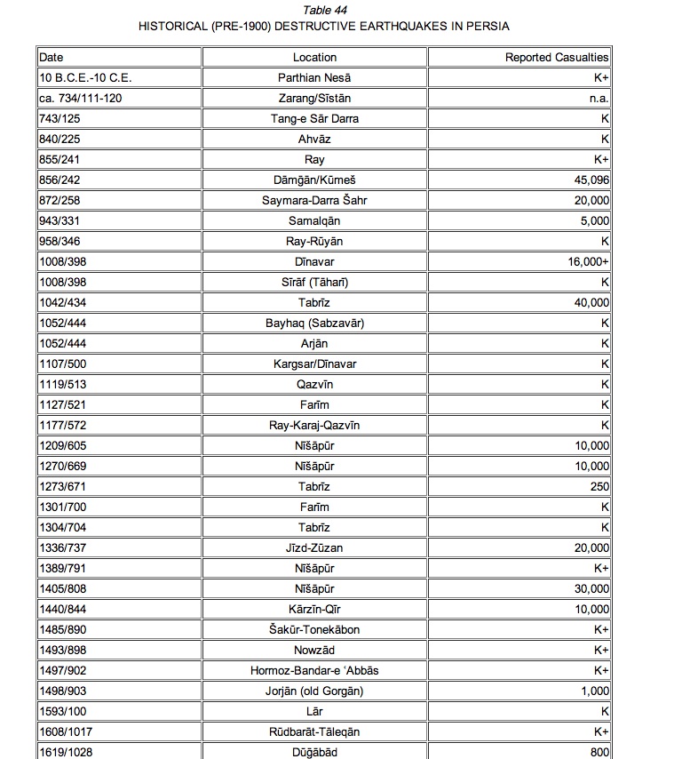
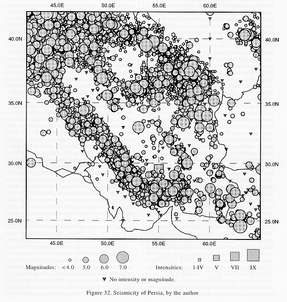
Historical (pre-1900) earthquakes. Historical records of catastrophic earthquakes have survived for centuries. At least nine destructive earthquakes in Nīšāpūr/Šādyāḵ have reduced the size and changed the location of the city several times (Melville, 1980, pp. 116-17). Ray has been devastated at least six times in its recorded history (Ambraseys, 1974, pp. 50-68; Berberian et al., 1985, pp. 221-30, 287). Almost all monuments in Tabrīz were destroyed or severely damaged by at least eight large-magnitude earthquakes, especially by the one on 29 Ḏu’l-Hejja 1193/7 January 1780, which reduced all buildings to rubble. Unfortunately, except for the Blue Mosque (Masjed-e-Moẓaffarīya) built in 870/1465, the city now has very few historical monuments (Ṭabāṭabāʾī-Tabrīzī, 1294/1877, p. 121; Berberian and Aršadī, 1976, pp. 397-418; Melville, 1981, p. 167; Golombeck and Wilber,1988, pp. 31, 407-409). Table 44 (Table 44a, Table 44b) lists the most important historical earthquakes in the Iranian plateau. (For more precise information, see Ambraseys and Melville, 1982, pp. 158-62; Berberian, 1994, pp. 11-413; Figure 32.)
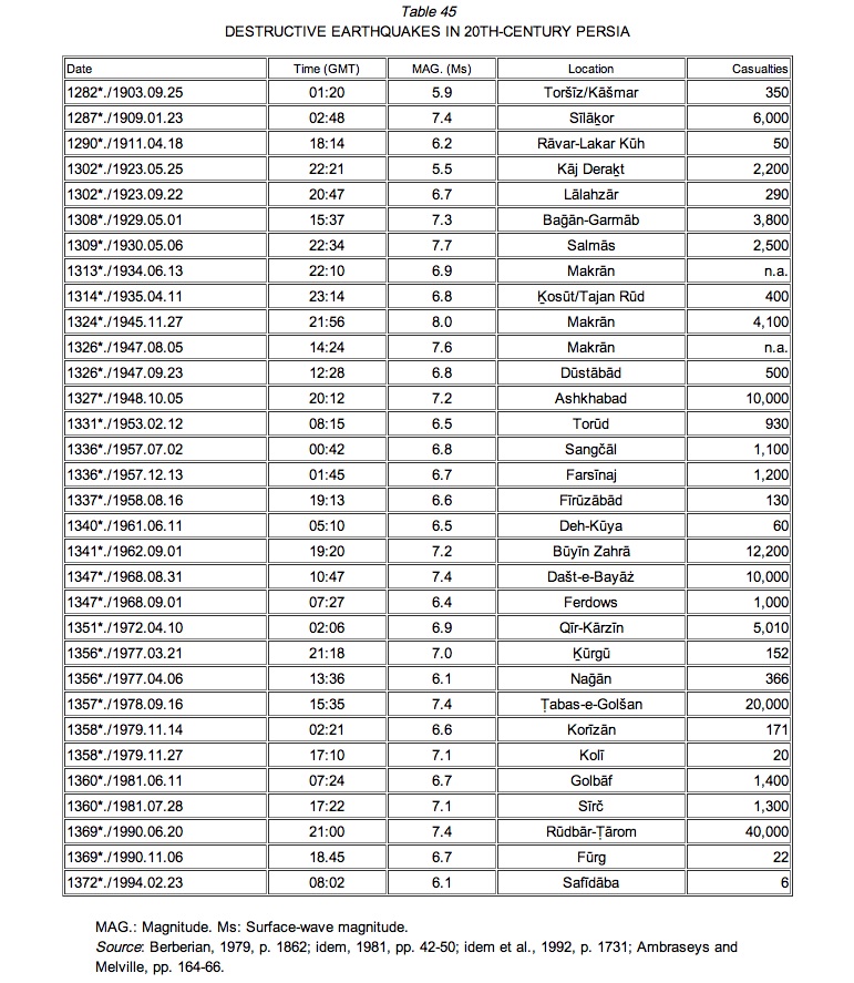
20th-century earthquakes. Since the beginning of this century at least 126,000 people have lost their lives in destructive earthquakes in Persia. These losses cannot be justified in light of existing scientific knowledge and expertise in disaster management. Table 45 lists the most important earthquakes in Persia since 1900.
The Ṭabas-e-Golšan earthquake of 25 Šahrīvar 1357/16 September 1978 (Ms=7.4; Berberian, 1979, pp. 1861-87; 1982, pp.449-530) and the Rūdbār-Ṭārom earthquake of 31 Ḵordād 1369/20 June 1990 (Ms=7.4; Berberian et al., 1992, pp. 1726-55) were the most catastrophic earthquakes to have occurred in Persia to date in the 20th century. The Ṭabas-e-Golšan earthquake destroyed or severely damaged about ninety villages, slightly damaged another fifty villages in the region, and completely demolished the oasis town of Ṭabas-e-Golšan, where 85 percent of the inhabitants (11,000 out of 13,000) perished. Total fatalities were more than 20,000 with thousands injured. This earthquake, strongly felt over an area of 1,130,000 square km, destroyed over 15,000 housing units and thirty qanāts in the epicentral region (Berberian, 1989, pp. 1861-87). The Rūdbār-Ṭārom earthquake, the largest in this century to affect an urban area in Persia, killed over 40,000 people, injured 60,000, and left more than 500,000 homeless. The earthquake destroyed three towns (Rūdbār, Manjīl, and Lowšān) and 700 villages and damaged another 300 villages in Gīlān and Zanjān provinces of northwest Persia, southwest of the Caspian Sea. Nearly 100,000 buildings were destroyed or badly damaged. Water supplies in 283 villages were destroyed or reduced by 70 percent, several thousand livestock were buried under debris, and farms and irrigation canals were seriously damaged. In addition, 1,200 km of rural roads now require repair or reconstruction (Berberian et al., 1992, pp. 1726-55). Economic losses caused by this earthquake have been estimated at $7.2 billion, constituting 7.2 percent of the GNP (UNESCO, DHA News, Department of Humanitarian Affairs, 1992, p. 30). The long-term effects of this catastrophic event, such as the disruption of major economic links between three large provinces, the resettlement of populations from at least three large towns and 700 villages, and the reconstruction of buildings according to modern standards will take decades to accomplish and will absorb a considerable part of the country’s resources.
Bibliography
N. N. Ambraseys, “Historical Seismicity of North-Central Iran,” Materials for the Study of Seismotectonics of Iran. North Central Iran, Geological Survey of Iran, Tehran, 1974, rep. no. 29, pp. 47-95.
N. N. Ambraseys and C. P. Melville, A History of Persian Earthquakes, Cambridge, 1982.
Ebn Marzbān Bahmanyār, Jām-e jahān-nomā, eds. ʿA. Nūrānī and M.-T. Dāneš-pažūh, Tehran, 1362 Š./1983.
M. Berberian, Contribution to the Seismotectonics of Iran, pt. II, Geological Survey of Iran 39, Tehran, 1976; pt. III, Tehran, 1977.
Idem, “Earthquake Faulting and Bedding Thrust Associated with the Tabas-e-Golshan (Iran) Earthquake of September 16, 1978,” Bulletin of the Seismological Society of America 69/6, 1979, pp. 1861-87.
Idem, “Active Faulting and Tectonics of Iran,” in H. K. Gupta and F. M. Delany, eds., Zagros-Hindu Kush-Himalaya Geodynamic Evolution, Geodynamics Series III, American Geophysical Union, Washington, D.C., 1981, pp. 33-69.
Idem, “The Southern Caspian: A Compressional Depression Floored by a Trapped, Modified Oceanic Crust,” Canadian Journal of Earth Science 20/2, 1983, pp. 163-83.
Idem, Continental Deformation in the Iranian Plateau (Contribution to the Seismotectonics of Iran, pt. IV), Geological Survey of Iran 52, 1983 (625 pp. in English; 74 pp. in Persian).
Idem, .Natural Hazards and The First Earthquake Catalogue of Iran; I: Historical Hazards in Iran Prior to 1900. UNESCO/IIEES publication during UN/IDNDR, Paris and Tehran, 1994.
M. Berberian and S. Arshadi, “On the Evidence of the Youngest Activity of the North Tabriz Fault and the Seismicity of Tabriz City,” Geological Survey of Iran 39, Tehran, 1976, pp. 397-418.
M. Berberian, J. A. Jackson, M. Qorashi, and M. H. Kadjar, “Field and Teleseismic Observations of the 1981 Golbaf-Sirch Earthquakes in SE Iran,” Geophysical Journal of Royal Astronomical Society ( London) 77, 1984, pp. 809-38.
M. Berberian, M. Qorayšī, B. Aržang-rāveš, and A. Mohājer-Ašja’ī, “Pažūheš o barrasī ...” (Recent Tectonics, Seismotectonics and Earthquake-fault Hazard Study of the Greater Tehran Region), Contribution to the Seismotectonics of Iran, pt. V. Geological Survey of Iran 56, Tehran, 1985; 2nd ed. 1371 Š./1992; and pt. VI, 61, Tehran, 1993.
M. Berberian, M. Qorashi, J. A. Jackson, K. Priestley, and T. Wallace, “The Rudbar-Tarom Earthquake of June 20, 1990 in NW Iran: Preliminary Field and Seismotectonic Observations and its Tectonic Significance,” Bulletin of the Seismological Soceity of America 82/4, 1992, pp. 1726-55.
G. L. Golinsky, “Description of the Major Earthquakes in Western Turkmenia SSR,” in N.V. Kondorskaya and N. V. Shebalin, eds., New Catalog of Strong Earthquakes in the USSR from Ancient Times through 1977, World Data Center A, U.S. National Oceanic and Atmospheric Ad-ministation , Denver (Col.), Report SE-31, 1982, pp. 519-24.
L. Golombek and D. Wilber, The Timurid Architecture of Iran and Turan, 2 vols., Princeton, 1988.
G. P. Gorshkov, Zemletryaseniya Turkmenii (Earthquakes of Turkmenia ), Trudy Seismol., no. 122, Akademi Nauk, Moscow, 1947.
K. H. Jacob and R. C. Quittmeyer, “The Makran of Pakistan and Iran: Trench-arc System with Active Plate Subduction,” in A. Farah and K. De Jong, eds., Geodynamics of Pakistan, Geological Survey of Pakistan, Quetta, 1979, pp. 305-17.
S. Kāmbaḵš-Fard, “Kāvešhā-ye ʿelmī …” (Excavations at Ānāhītā Temple, Kangāvar). Bāstānšenāsī o honar-e Īrān, … Archaeological Institute, nos. 11-12, 1353 Š./1974, pp. 40-49.
Šaraf-al-Dīn Moḥammad Masʿūdī Marvazī, Do resāla dar āṯār-e ʿolwī, ed. M.-T. Dānešpažūh, Tehran, 1337 Š./1958.
C. P. Melville, “Earthquakes in the History of Nishapur,” Iran XVIII, 1980, pp. 103-22.
Idem, “Historical Monuments and Earthquakes in Tabriz,” Iran XIX, 1981, pp. 159-71.
Ḥamd-Allāh Mostawfī Qazvīnī, Nozhat al-qolūb, Pers. tr. M. Dabīrsīāqī, Tehran, 1336 Š./1957; Eng. tr. Le Strange. Moses Khorene, History of the Armenians, tr. Thompson. B. Nāderī, “Masjed-e-Jāmeʿ-e Qāen,” Našrīya-ye sāzmān-e mellī-e ḥefāzat-e āṯār-e bāstānī (Bulletin of the National Organization for the Protection of Ancient Heritage) 10, 1359 Š./1980, pp. 103-07.
Nāṣer-e Ḵosrow, Safar-nāma wa zād al-mosāferīn, ed. M. Dabīrsīāqī, Tehran, 1355 Š./1976.
E. O. Negahbān, “Gozāreš-e moqadamātī …” (Preliminary Report of the Excavation of Sagzābād, 1970 Season), Mārlīk I, Esfand 1351 Š./March 1973, pp. 11-13.
Idem, “Silver Vessels of Marlik with Gold Spouts and Impressed Gold Designs,” Iranica Varia 16, 1990, pp. 144-51.
A.-A. Sarfarāz, “Bīšāpūr,” in Šahrhā-ye Īrān (Iranian Cities), ed., M.-Y. Kīānī, Tehran, 1366 Š./1987, pp. 23-74.
Šāhmardān b. Abi’l-Ḵayr, Nozhat-nāma-ye ʿAlāʾī, ed. F. Jahānpūr, Tehran 1362 Š./1983.
M.-R. Ṭabāṭabāʾī-Tabrīzī, Tarīḵ-e-awlād al-aṭhār, Tabrīz, 1304/1887, and Tehran, 1314/1896.
Moḥammad b. Maḥmūd b. Aḥmad Ṭūsī, ʿAjāʾeb al-maḵlūqāt wa ḡarāʾeb al-mawjūdāt, ed. M. Sotūda, Tehran, 1345 Š./1966.
T. Cuyler Young, Jr., “Godin Tepe,” Iran VI, 1968, pp. 160-61.
Idem, “Godin Tepe,” Iran X, 1972, pp. 184-86.
T. Cuyler Young, Jr., and H. Weiss, “Godin Tepe,” Iran XII, 1974, pp. 207-11.
Zakarīyā Qazvīnī, Zakarīyā b. Moḥammad …, Aṯār al-belād wa aḵbār al-ʿebād, ed. F. Wüstenfeld, Göttingen, 1848; partial Pers. tr. ʿA.-R. Šarafkandī, Tehran, 1366 Š./1987.