


ii. IN CENTRAL ASIA
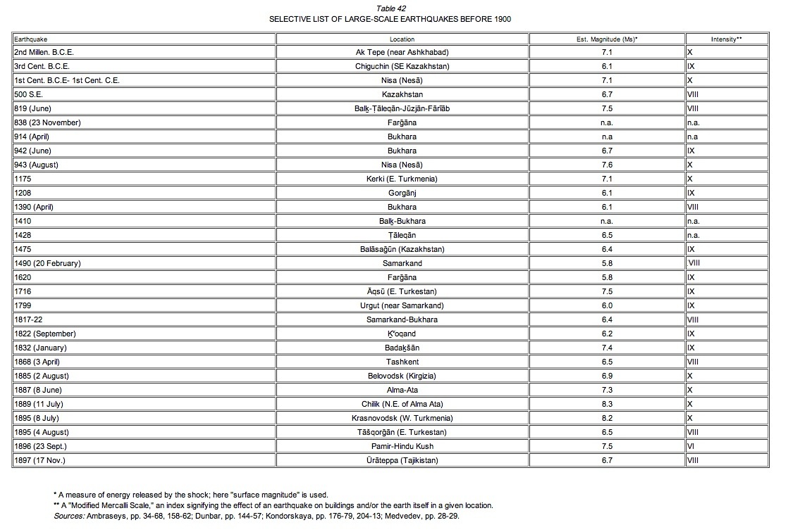
Central Asia lies in the Mediterranean-Himalayan seismic belt and comprises two distinct regions of high seismic activity (Table 42, Table 43). The first, in southwest Turkmenistan, includes two seismic zones: i) the Krasnovodsk area, along the eastern coast of the Caspian Sea, which is associated with the larger zone of the conjunction of the uplifted Kuba Dagh-Greater Balkan tectonic structure with the Trans-caspian depression; ii) the Ashkhabad area, which borders on a highly active region in northern Persia. Most of the epicenters in the latter zone lie near the Kopet Dag fault, where the greatest tectonic activity is concentrated (Medvedev, pp. 300-13).
The second region includes the territories of Tajikistan, Kirgizstan, southeastern Uzbekistan, southeastern Kazakhstan, and eastern Sinkiang Province in China. A heterogeneous tectonic area, including territories of Caledonian, Variscan, and Alpine folding, this region is enlaced by a fairly complicated network of faults characterized by both horizontal and vertical displacements of recent development (Nalivkin, pp. 533f; Leith, pp. 1-22). Researchers have proposed that seismic activity in the region derives from continental collision between the Indian and Eurasian plates, beginning about 40 million years ago (Molnar and Tapponnier). The longest fault in the region, the Talas-Farḡāna fault, is oriented NW-SE and extends for over 1,500 km, cross-cutting the Tien Shan mountain range for over 600 km. For approximately 700 km along the southern boundary of the Tien Shan, another zone of seismicity several tens of kilometers wide follows the EW-oriented Gissar(Ḥeṣār)-Kokshal fault zone. The two other major faults are the Darvāz-Karakul and Central Pamir faults, both of which extend from the Tarim Basin to the Hindu Kush, skirting the northern Pamirs (Burtmen; Kristy; Molnar and Qidong).
Between these two active regions, there is another of lesser activity, with only isolated known foci, along the lower course of the Oxus river, encompassing the regions of Marv, Čārjū (Āmol), Bukhara, and Ḵᵛārazm—the sites of the oldest extant cultural monuments in Central Asia. However, several earthquakes have been reported in this area in the last millennium. Even the northward shift of the course of the Oxus has reputedly been ascribed, in the Khivan tradition, to a strong earthquake (Ambraseys, p. 149).
The earthquakes listed in Table 42 have been identified principally from historical sources but also, in a few cases, from archaeological or geological evidence. The earliest traces of macroseismic activity in Central Asia may be in Ak-Tepe, in the vicinity of Ashkhabad, where archaeological evidence suggests that an earthquake during the second millennium B.C.E. damaged a building structure (Kondorskaya, pp. 519f.). Evidence for the strong earthquake that destroyed old Nisa (Nesā) west of Ashkhabad for the first time is also archaeological, so that the date remains only approximate (idem). Literary sources, however, describe a second earthquake that destroyed the city in Ḏu’l Hejja 331/August 943), taking more than 5,000 lives (Gardīzī, ed. Ḥabībī, p. 155; Ebn al-Aṯīr, VIII, p. 404). Abū Dolaf also describes the destruction of dozens of villages in the Salmaqān valley by the same earthquake (Ambraseys, p. 39). The Kerki earthquake of 1175 presents a case where historical sources corroborate the geomorphological evidence (Kondorskaya, p. 525).
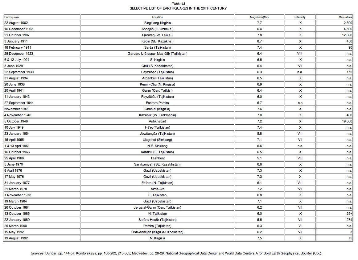
Owing to lack of historical evidence, incidents in the more earthquake-prone regions of Central Asia are less represented in Table 42 than in Table 43. Tajikistan is among these regions: on the average, it suffers a destructive earthquake every ten to fifteen years, with an annual incidence of thousands of recordable seismic events (Kukhtikova; Roecker). Most of these smaller events lie below the threshold of human perception, but a traditional Now-rūz custom reveals that they may be strong enough to displace an egg on a flat mirror, a sign of the beginning of the new year.
The fact that Central Asia possesses the highest level of seismicity in the continental territory of the former Soviet Union has made it the subject of a strikingly large number of seismological and seismotectonic studies. As part of a countrywide network—first Russian and then Soviet—the following seismic stations were installed prior to the Second World War: Tashkent (1902), Alma Ata [formerly Vernyi] (1907), Frunze [formerly Bishkek] (1927), Andejān (1929), Samarkand (1929), and Čimkent (1934) (Ambraseys, pp. 134-37). It was not until one year after the highly destructive Fayżābād earthquake sequence of 1943 that a seismic station was set up in Dushanbe, followed by one in Ashkhabad in 1947 (idem). In the 1950s, further development of seismic studies of Central Asian territories resulted from two catastrophic earthquakes: that of 1948 in Ashkhabad, whose toll of 19,800 lives was kept secret by the Soviet Union until the late 1980s, and that of 1949 in Ḥāʾeṭ, during which an enormous landslide buried the center of that Tajik district, and 150 other settlements suffered heavy damage (Kukhtikova).
Active work on earthquake prediction began after the Tashkent earthquake of 1966, the focus of which appeared beneath the center of the city, causing significant destruction despite its relatively low magnitude. Seismic outposts called “polygons,” containing extensive instrumentation for earthquake prediction, were installed in the regions of Ashkhabad, Tashkent, Frunze-Alma Ata, Osh, and Dushanbe-Ḡarm, all being regions calculated to be particularly vulnerable to earthquakes (Nersesov). An improved version of the seismic zoning map of the Soviet Union, originally published with a scale of 1:5,000,000 during the mid-1950s (Medvedev, p. 65), was republished with a scale of 1:1,500,000 in the 1970s. Subsequently, more detailed maps were prepared for individual regions of Central Asia (Sodovsky; Asimov et al.).
During the détente years of the early 1970s, scientific agreements for environmental protection between the United States and the Soviet Union led to several joint studies aimed at earthquake prediction. Under this agreement a number of Western researchers visited Central Asia and, in conjunction with the republics’ Academies of Sciences, conducted field studies on the seismicity and seismotectonics in the region. In recent years, continued seismological studies in Central Asia have been conducted under the “Joint Seismic Program” (IRIS Consortium). A prominent institution for the study of earthquakes in Central Asia is currently the Institute of Seismic Resistant Construction and Seismology of the Academy of Sciences of Tajikistan, founded in 1951. This organization has conducted both experimental and theoretical research and has participated in major construction and engineering projects in Tajikistan (Asimov and Negmatov). In the 1980s, the institute issued the annual publication Zemletryaseniy v sredney Azii i Kazakhstana (Earthquakes in Central Asia and Kazakhstan) and Prognoz zemletryasenii (Earthquake Prediction).
Bibliography
N. N. Ambraseys and C. P. Melville, A History of Persian Earthquakes, Cambridge, 1982.
M. S. Asimov and N. N. Negmatov, “Tajik Soviet Socialist Republic: Science and Scientific Institutions,” Great Soviet Encyclopaedia (tr. from 1976 Russian ed.), XXV, A. M. Prokharov, ed., New York, 1980, pp. 300-03.
M. S. Asimov et al., “On the State of Research Concerning Earthquake Prediction in the Soviet Republics of Central Asia,” Earthquake Prediction: Proceedings of International Symposium on Earthquake Prediction, Tokyo, 1984, pp. 585-95.
V. S. Burtman, “Faults of Middle Asia,” American Journal of Science 280, 1980, pp. 725-44.
P. K. Dunbar, P. A. Lockridge, and L. S. Whiteside, eds., Catalogue of Significant Earthquakes 2150 B. C.-1991 A. D., World Data Center A, Boulder (Col.), 1992. IRIS Consortium, “Installation of Seismic Stations,” 1993 Annual Report, Arlington (Va.), 1994, pp. 22-26.
N. V. Kondorskaya, and N. V. Shebalin, eds., NewCatalog of Strong Earthquakes in the USSR from Ancient Times through 1977, World Data Center A for Solid Earth Geophysics, Boulder (Col.), 1982.
M. J. Kristy and D. W. Simpson, “Seismicity Changes Preceding Two Recent Central Asian Earthquakes,” Journal of Geophysical Research 85/B9, 1980, pp. 4829-37.
T. I. Kukhtikova et al., “Zilzila,” Entsiklopediyai sovetii tojik, 2 vols., M. S. Osimi (ʿĀṣemī), ed., Dushanbe, 1980, II, pp. 490-92.
W. Leith, The Tajik Depression, USSR: Geology, Seismicity and Tectonics, unpubl. Ph.D. dissert., Columbia University, 1984.
S. V. Medvedev, ed., Seismic Zoning of the USSR (tr. from 1968 Russian edition), Jerusalem, 1976.
P. Molnar and D. Qidong, “Faulting Associated with Large Earthquakes and the Average Rate of Deformation in Central and Eastern Asia,” Journal of Geophysical Research 89, 1984, pp. 6203-27.
P. Molnar and P. Tapponnier, “Cenozoic Tectonics of Asia: Effects of a Continental Collision,” Science 189/4201, 1975, pp. 419-26.
D.V. Nalivkin, Geology of the USSR (tr. from Russian, Moscow-Leningrad, 1962), Edin-burgh, 1973.
S. W. Roecker, “Velocity Structure of the Pamir-Hindu Kush Region: Possible Evidence of Subducted Crust,” Journal of Geographical Research 87/B2, 1982, pp. 945-59.
M. A. Sadovsky and I. L. Nersesov, “Earthquake Prediction Problems in the USSR,” Proceedings of the Seminar on Earthquake Prediction Case Histories, Geneva, 1983, pp. 35-49.