

KASHAN
ii. Historical Geography
Geographic foundations and the origins of the urban area. To the northeast of the well-watered mountain ranges of western and southern Iran, a line of bountiful oases which have given rise to important urban areas stretches along the piedmont bordering the desert basins of central and southeastern Iran. Kashan belongs to this series, in contact with the great Kavir (see desert) to the east, while to the southwest lies the Karkas mountain, an extensive line of relief oriented from northwest to southeast approaching 4,000 m in altitude (see “Karkas” and “Kargez” in Jaʿfari, pp. 427-29). To the south the city commands relatively easy passes across this line of mountains, which runs parallel to the principal course of the Zagros range but is independent of it; these passes lead to the important oasis of Isfahan, the major center of population in central Iran. To the north, via Qom, the piedmont of the Alborz is easily reached. In the very arid climate of the piedmont of the Karkas mountain, the extent of urban areas is necessarily tied to the availability of water resources. The site of Kashan is linked to a great spring near the large village of Fin (see bāḡ-e fin) some 10 kilometers southwest of the city, which supplies the sole continuously flowing watercourse of the whole area along the mountains; otherwise only seasonally flowing torrents are to be found. Downstream from the spring, the river made it possible to bring under irrigated cultivation an alluvial fan oriented southwest-northeast, some 20 kilometers long and around 3 to 4 kilometers wide; this fan was deposited by the river before its percolation into the sands of the Kavir near two large towns, Ārān and Bidgol, which early displayed urban characteristics and today have become true satellite cities of Kashan.
How are we to explain the actual location of Kashan on the alluvial fan, and at what date did the urban area develop? It certainly benefited from its fortunate location on the oasis—it is about equidistant from the two extremities of this long, rectangular ribbon of fields and gardens, and one may deem this factor to have been decisive. Such an advantage, however, took a long time to appear, and at different times other villages could probably have laid claim to preeminence. This could hardly have applied to Ārān and Bidgol; their position as the farthest downstream of a chain of villages was not favorable for the establishment of economic and social superiority, since they were not able to control the distribution of the water. From the presence of numerous ruins around Ārān, we can assume that the modern city might have been relatively more important in former times and that the advance of the desert sands could have led to its decline. Yet it is precisely the reduction of available water over the course of time, as areas upstream increased their consumption, that can explain the advance of the desert. At the farthest distance upstream, meanwhile, the site of Fin benefited from its proximity to the spring, the abundant water, and the attractiveness of the verdant landscape, though the relative narrowness of the cultivable area at this point, where the alluvial fan was far from reaching its greatest breadth, was a decisive factor restricting further expansion. Furthermore, when oases are linked to rivers it is extremely rare for the principal settlement to be situated at the farthest point upstream; rather, it almost always ends up being established in a more central location, or even farther downstream, as in the case of Isfahan, for example. But even in this middle area itself it is certain that other choices were possible. In fact, the oldest major population center seems to have been Sialk, midway between Fin and modern Kashan near the modern village of Dizče, where excavations carried out by Roman Ghirshmanin the 1930s revealed the existence of an important settlement dating as far back as the second half of the fifth millennium BCE. Some 800 years later a second notable site developed next to the first, about 600 meters to the north. Life continued at these sites up to the beginning of the first millennium BCE, at which time we find new arrivals settling among them, who were probably the first Aryan invaders. But around 800 BCE a catastrophe of unknown origin brought about the complete ruin of Sialk and the final abandonment of the two sites, which today are revealed only by artificial mounds.
At what date, then, did the development of present-day Kashan occur? The traditions concerning this subject, sometimes quite fanciful, hardly provide us with useable data. No historical value can be attached to the account related by Ḥamd-Allāh Mostawfi (p. 67), attributing its foundation to Zobayda, wife of Hārun al-Rašid. Indeed, the Arabic texts indicate specifically that it was taken and pillaged by the Muslim invaders at the time of the conquest (Balāḏori, pp. 312-13). The earlier periods, however, remain in complete obscurity. Although there are popular etymologies of local place names and imagined traditions about foundation of the city by the mythical rulers of Persia (on whom, see KAYANIDS), these have no historical value. Nor can any historical conclusion be drawn from comparison of the name of the city with the name of the earthenware called kāši (see ceramics xiv), for which the city was long renowned. The term kāši is readily explained as a contraction of Kāšāni (cf. the nesba name “Kāši” alongside “Kāšāni”: see below, kāši, ḡiāṯ-al-din). We can only say that the origins of the city are probably very ancient, as already indicated by Moqaddasi (p. 390). A major argument in favor of this idea is suggested by its location on the central part of the alluvial fan, obviously connected to a water supply that was originally maintained exclusively by channels leading from the river. Although today the qanāts (see kāriz) furnish a major part of the water for the city and its immediate surroundings (Costello, pp. 60-61), Kashan most probably existed prior to the diffusion of this technique, that is, before the first half of the first millennium BCE. We cannot absolutely exclude the possibility that a village settlement as old as Sialk, now hidden by the structures of the modern city, could have existed on the same site. The early Western visitors to the city attributed an ancient past to it, as the point of departure of the three Magi from the East (Matt. 2:1) in Christian tradition. Marco Polo (traveling in 1272) tells their story in detail, and he claims to be relating the narrative he heard at the “Castle of the Fireworshippers” in the vicinity of Kashan (ed. H. Yule, 2nd. ed., London, 1875, I, pp. 79-81); the Franciscan friar Odoric de Pordenone (reaching the city in 1320 or 1321) refers to the association with the Three Kings (see, e.g., Lockhart, pp. 73-74).
Development and decline. At the beginning of the Islamic period Kashan was still considered a “small city” in geographical works in Arabic (Eṣtaḵri, pp. 8, 201; Ebn Ḥawqal, tr. Kramers, p. 362), markedly smaller than Qom (as related by Abu’l-Fedāʾ, p. 421; cf. Schwarz, Iran V, p. 568). In the course of the following period, however, it clearly benefited from the development of activity on the Iranian plateau, where its central location and convenient connections made it a very important crafts center. This progress can be seen in the successive texts which depict it as “prosperous,” henceforth a city of “medium size” (Mohallabi in Abu’l-Fedā). Moqaddasi (p. 392) portrays it as flourishing, and this would later be confirmed by Yāqut in his depiction of the city on the eve of the Mongol invasion and its destruction in 1224. An important mint existed there from the Buyid period, and the circulation of Kashan dinars was considerable (data collected in Schwarz, Iran, V, pp. 569-70). A varied craft industry developed there; in particular, different forms and shapes of glazed earthenware containers were made and exported to many regions. The city was celebrated by the poets, and the large proportion of Shiʿites among its population was also mentioned. The only feature that detracted from its reputation was the presence of a large number of scorpions.
This prosperity continued through a large part of the modern period. Recovery seems to have been rapid after the ravages of the Mongols. Friar Odoric of Pordenone, in his travel account (see above), mentions the ruins left by their devastations but nonetheless describes the city as “noble and renowned” (Lockhart, loc. cit.) The taxes paid to the treasury by the city and its environs grew during the same period (1340) to 117,000 dinars, or close to three times the sum paid by Qom (Ḥamd-Allāh Mostawfi, p. 67).
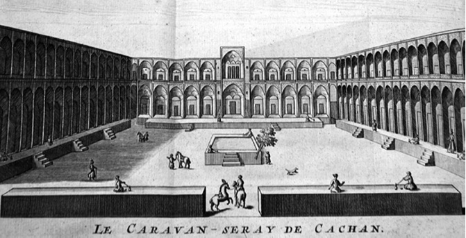
The Safavid period was particularly prosperous. The city was favored by the Shiʿite dynasty, to which it had rallied with enthusiasm. The court frequently stayed there, and Shah ʿAbbās was buried there in 1629, following his own instructions. During this period Kashan benefited extensively from its central location and its proximity to Isfahan. From the year 1573 it was described as a very active commercial center with far-reaching connections, frequented by numerous traders from India, a city where silk and spices were sold and where the production of luxury goods was very important (Plumtree, in Bannister and Ducket, Hakluyt, I, p. 396), and this information is confirmed at the beginning of the 17th century (Cartwright, in Purchas, II, p. 1432). Sir Thomas Herbert (p. 217), who visited there in 1628, estimated the presence of 4,000 households and compared the city’s importance to that of York and Norwich, with attractively built houses hidden among their gardens; according to him, “in a word, a more industrious and civil people or a town better governed, Persia elsewhere has not.” Jean-Baptiste Tavernier, who began his travels in the years 1631-33, describes it (p. 80) as “a large, well-populated city,” with “beautiful and well-vaulted bazaars” and “large and commodious caravanserais.” The city included “a great many workers in silk” and around 1,000 Jewish families, who made wine there. The growth of the city at this time must have been rapid. A little later Sir John Chardin (II, pp. 462-63; q.v.), who saw it in 1673, counted 6,500 houses. (For a general view of a prosperous caravansary in Safavid Kashan, see Figure 1.)
At the beginning of the 19th century, Kashan, which like the rest of the country had suffered greatly from the troubles of the 18th century, and which had been ravaged by an earthquake under Karim Khan (q.v.), already presented a much less appealing appearance (Malcolm, II, p. 4). Its artisans, however, notably those working in silk, cotton, and copper, were still very active during the first half of the century, and their products were exported in particular to Russia (Waring, p. 76; de Bode, I, p. 29; cf. Schwarz, p. 570). It was at the end of the 19th century that the decline became more pronounced in the face of competition from European products. Lord Curzon (II, p. 14) described it at that time as “outwardly, one of the most dilapidated cities in Persia. A more funereal place I have not yet seen.” Sir Percy Sykes (p. 158; q.v.) saw only a mass of miserable hovels there. It would take a long time for this impression to fade. In the 1950s another English ambassador described it as “the most depressed small town in Persia” (Stevens, 1962). Estimates of the population given by European travelers— almost impossible to refine, given what largely appeared as a field of ruins in which the proportion of uninhabited houses was very high—varied considerably, probably more than for any other Iranian city. Curzon (II, p. 14) notes that these estimates varied from 5,000 to 95,000 inhabitants, and although he considered Sir Albert Houtum-Schindler’s (q.v.) estimate of 30,000 inhabitants in 1885 to be plausible, and although those of Ritter (IX, p. 35: 15,000) and Stahl (p. 23: 20,000) might be equally valid, none of these indications is in fact based on any real data.
Industrialization and recent efflorescence. Was this center of intense productive and commercial activity, one of the most renowned in Iran, destined for an unavoidable decline? In fact, its brilliant prosperity during the Safavid period could only have been linked to the general strength of the country and its long-distance commercial relations. In Qajar Iran (1779-1925), when the economy greatly declined, the city lacked the local foundations, particularly agricultural, necessary to an important city. The flow of running water to which it owed its origin on the alluvial fan was quite insufficient to maintain a significant extension of the oasis. The qanāt had long since become the principal source of water. In 1966 they were the main water supply in 180 towns in the province, while only 42 were supplied by surface water (Costello, 1976, pp. 59-61). But it had already been a half-century since any new qanāt had been constructed. Deep wells had only a limited development (ibid., p. 54); they were particularly difficult to dig, having to reach a water table that was situated at a minimum depth of 100 or 150 meters and that regularly ran low. For a long time Kashan had not been able to feed itself on the basis of local agricultural production. Already in 1894 a report from a British consul indicated that Kashan had to be supplied with the grain for its subsistence from the great oasis of Isfahan (Costello, p. 110). A renaissance could come only from a new integration, via industrialization, with the external economy.
It was Kashan’s good fortune to again find in the initiative of its population, educated by a long tradition of perfection in handicrafts, the innovations that would make new stages of economic activity possible. In the last decade of the nineteenth century the weaving of rugs, one of the most important industries of the city, was still essentially based on silk from Gilān; the city supplied only products of high quality which were very costly and in decline on the world market. But then one of the city’s merchants, whose wife was originally from Arāk, already a great center at the time for the making of modern carpets, began using an unsold stock of thread from Manchester to weave woolen rugs which were much more rustic and readily marketable. This led to a great upsurge in their production (Edwards, p. 334) in the city and, through the impetus of the city’s merchants, throughout its rural zone of influence. The accumulation of capital realized by these great carpet merchants became, in turn, the foundation in the 1930s of the large, modern manufacturing industry, including the spinning and weaving of cotton and then of wool and artificial fibers. Great enterprises like the Kashan Spinning Company (founded in 1932, with 1,850 employees in 1968), then the Kashan Velvet Company (developed during the 1940s, with 1,300 employees in 1966), and still later the Kāmvā-ye Irān Company in the 1960s (with capital from Tehran) were established in the city, working mainly with untreated wool from Australia (Costello, 1976, pp. 123-24). The original feature of this development is that, in an Iran where industrialization was still mainly realized through state initiative, in Kashan it was carried out totally with private capital, expressing the enterprising spirit of the local population. Based almost exclusively on textile production until the 1970s, industry then began to timidly diversify, notably in the metallurgical and mechanical sectors.
For the past half-century the population growth linked to this economic development has been spectacular. Kashan even qualified as a “mushroom city” (that is, the population doubled in less than 10 years) between 1956, when the census counted 25,953 inhabitants, and 1966, when it had grown to 58,468, during the period of the first boom in textile production. Even though the rate of increase subsided somewhat after that time, growth remained rapid, and the population reached 138,599 inhabitants in 1986 and 201,372 in 1996. The old city, shaped roughly like a rectangle around a long bazaar (Wirth, 1974-75; plan reproduced in Wirth, 2000, I, pp. 190, 470-71), henceforth occupied only a small portion of an urban area extending in all directions.
Bibliography
Abu’l-ʿAbbās Aḥmad b. Yaḥyā al-Balāḏori, Fotuḥ al-boldān ed. M. J. de Goeje, Leiden, 1886; 2nd ed., Leiden, 1968.
B. C. A. de Bode, Travels in Luristan and Arabistan, 2 vols., London, 1845.
J. Chardin, Voyages en Perse . . . , 10 vols., ed. L. Langlès, Paris, 1784.
V. F. Costello, “The Industrial Structure of a Traditional Iranian City,” Tijdschrift voor Economische en Sociale Geografie 64, 1973, pp. 108-20.
Idem, Kashan: A City and Region of Iran (University of Durham, Centre for Middle Eastern and Islamic Studies, 3), London, 1976.
G. N. Curzon, Persia and the Persian Question, 2 vols., London, 1892.
A. C. Edwards, The Persian Carpet, London, 1938.
Abu Esḥāq Estaḵri, Masālek al-mamālek, ed. M. J. de Goeje, BGA, Leiden, 1870; 2nd ed., Leiden, 1927; 3rd ed., Leiden, 1967.
Abu’l-Fedāʾ, Taqwim al-boldān, ed. M. Reinaud and Mac Guckin de Slane as Géographie d’Aboulféda, Paris, 1840.
R. Ghirshman, L’Iran des origines à l’Islam, Paris, 1951.
R. Hakluyt, Principal Navigations, Voiages, Traffiques and Discoveries, London, 1598.
ʿA. Jaʿfari, Gitāšenāsi-e Irān I, Kuhhā va kuh-nāme-ye Irān, Tehran, 3rd ed., 2005.
Ḥamd-Allāh Mostawfi, Nozhat alqolub, ed. G. Le Strange as The Geographical Part of the Nuzhat-al-Qulūb, London, 1915.
T. Herbert, Travels in Persia, ed. W. Foster, London, 1928.
Abu’l-Qāsem b. Ḥawqal, Ṣurat al-arż, tr. J. H. Kramers and Gaston Wiet as Configuration de la terre, 2 vols., Paris and Beirut, 1964.
L. Lockhart, Famous Cities of Iran, Brentford, UK, 1939.
J. Malcolm, Sketches of Persia, 2 vols., London, 1815.
Abu ʿAbd-Allāh Moḥammad Moqaddasi (Maqdesi), Ahṣan al-taqāsum fi maʿrefat al-aqālim, ed. M. J. de Goeje, BGA, Leiden, 1877; repr., 1967.
O. de Pordenone, Les voyages en Asie du Bienheureux frère . . . , ed. M. Cordier, Paris, 1891. S. Purchas, Purchas his Pilgrimes . . . , 4 vols., London, 1625.
C. Ritter, Die Erdkunde von Asien VIII, Berlin, 1838.
P. Schwarz, Iran im Mittelalter V, Leipzig, 1925.
A. F. Stahl, “Reisen in Nord- und Zentralpersien,” Petermanns Mitteilungen, Ergänzungsheft 25, 1907.
R. Stevens, The Land of the Great Sophy, London, 1962.
P. M. Sykes, Ten Thousand Miles in Persia or Eight Years in Iran, London, 1902.
J.‑B. Tavernier, Les six voyages de . . . , Utrecht, 1712.
E. S. Waring, A Tour to Sheeraz, London, 1807.
E. Wirth, “Zum Problem des Bazars (suq, çarsi): Versuch einer Begriffsbestimmung und Theorie des traditionellen Wirtschaftszentrums der orientalisch-islamischen Stadt,” Der Islam 51, 1974, pp. 203-60; 52, 1975, pp. 6-46.
Idem, Die orientalische Stadt im islamischen Vorderasien und Nordafrika, 2 vols., Mainz, 2000.