


i. Geography
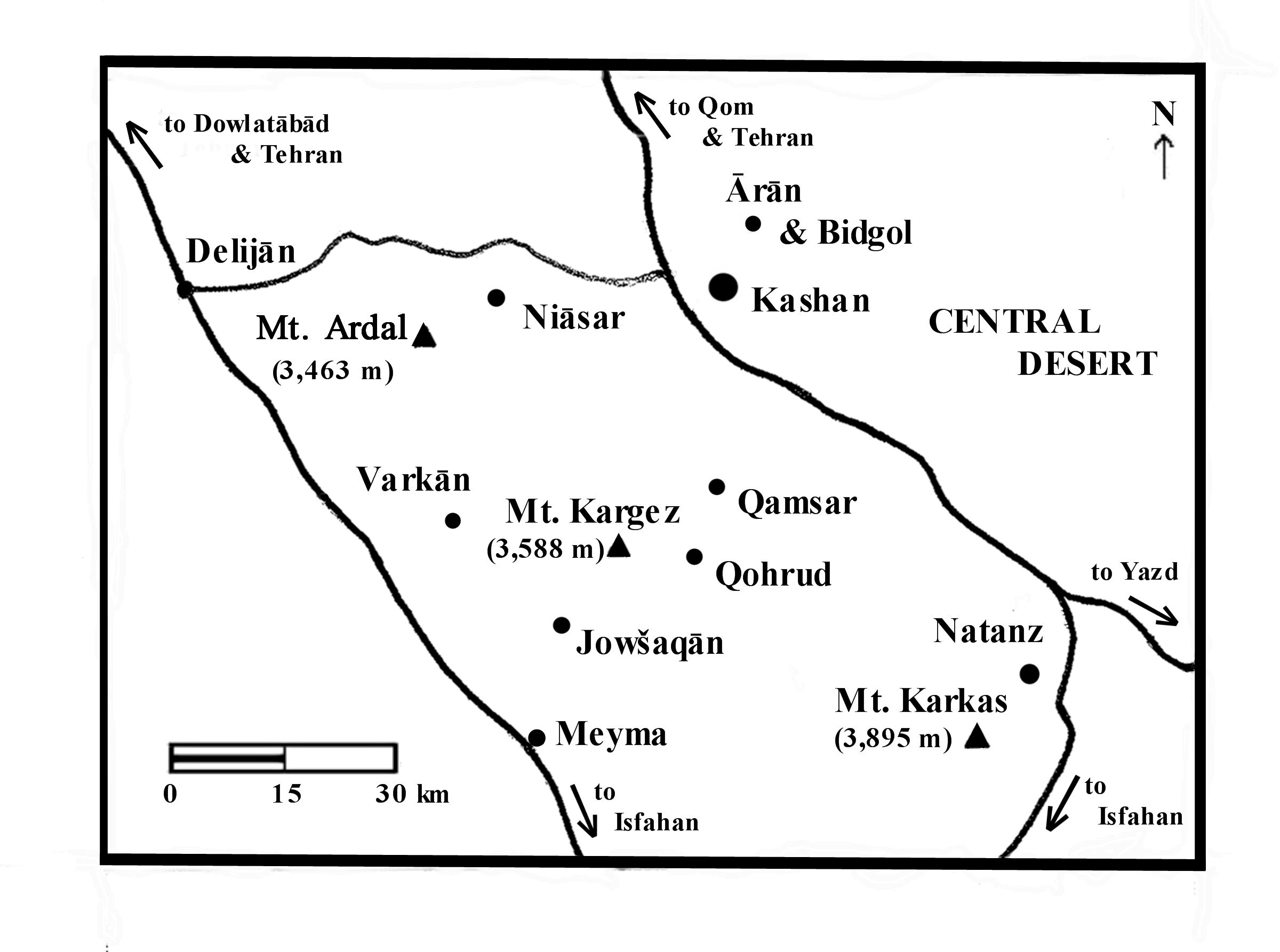
Physical geography. Covering an area of approximately 9,647 km2, the sub-province of Kashan is situated between the Karkas mountains on the west to the Central Desert on the east (see desert; Jaʿfari, 1989, pp. 427-29, 244-45, 353). The Karkas range divides the sub-province into two distinct topographic and climatic areas: the more temperate western highlands and the arid eastern lowlands. Although the town’s elevation is 950 m above sea level, it still has a warm climate due to proximity to the Central Desert (see Figure 1). The annual average temperature in the town is 19° C, with wide variations in the course of a year that may cover a range of 50° C. These variations may be seen in the day-to-day reports, at the Kashan city website (www. kashan.ir) and other online weather services, giving the data from the Kashan weather station (International Civil Aviation Organization i.d. OIFK). Some comparable monthly data (in Fahrenheit) is found in the 19th-century British gazetteer material, summarized as the “mean of 4 years, 1881-84 (approximate)” (Adamec, p. 320; table, p. 321). Precipitation at Kashan occurs mainly as rain and is concentrated during the winter/spring wet season. The annual rain- and snowfall has been averaged as 137 mm (Komaki, p. 167); as in the case of temperature, the amount of precipitation is subject to wide variation from year to year.
The few rivers flowing from the mountains to the desert are small and temporary. The most important is Šāh-āb, which originates in the Qohrud heights (Keyhān, I, p. 402; Jaʿfari, 1997, pp. 247-49). Irrigation is mainly dependent on the piedmont pockets of water carried to the plains by means of subterranean channels (see kāriz), even if the water is slightly salty. These sources are supplemented by several springs, the most notable of which is the Fin čašma (Razmārā, III, p. 222; Adamec, pp. 319-20).
The sub-province is generally poor in flora and fauna. The most typical plants are bushes and shrubs spreading over the steppes, but the landscape becomes richer with the increase in elevation. Characteristic trees are pine, cypress, black poplar (kabuda), elm, and ash (Šafaqi, pp. 128-35). Most of the highland’s small forests are already extinct, as the trees have been burned for charcoal (see forests). The sub-province is famous for production of figs and pomegranates from Fin, rosewater from Qamṣar, as well as melons and grapes.
Political geography. As a sub-province of Isfahan, Kashan is bounded in the west by Delijān Sub-province of Markazi Province, in the northwest and north by Qom Sub- province in Qom Province, in the northeast by the Ārān and Bidgol Sub-province, in the southeast and south by Naṭanz Sub-province, in the south and southwest by Borḵᵛār and Meyma Sub-province of Isfahan Province (cf. Jaʿfari, 2005, III, p. 966). During the 50-year census period from 1956 to 2006, the sub-province of Kashan belonged to various provinces. During the 1956 census, it was part of the Second Province centered at Gorgān; in the 1966 and 1976 censuses, it was part of former Markazi (Central) Province (currently divided into the provinces of Qazvin, Qom, Tehran, and Markazi); since 1986, the subprovince has been part of Isfahan Province.
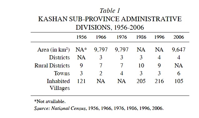
During the period 1956-2006 the boundaries of the subprovince did not remain stable, and its administrative divisions (districts, towns, rural districts, and villages) underwent a number of changes. With regard to its boundaries, the most significant changes occurred between 1966 and 1976, when the district of Naṭanz (q.v.) was separated to form its own sub-province, which became part of Isfahan Province. Between 1996 and 2006, the district of Ārān and the rural district of Kavirāt were separated from Kashan to form the Ārān and Bidgol Sub-province, which also became a part of Isfahan Province. These changes can be observed in a comparison of the maps of Kashan Sub-province from 1956 and 2006. Other changes in the administrative divisions of Kashan Sub-province are shown in Table 1. Despite these recurring administrative changes, the Kashan region can be delineated culturally by its characteristic Esbandi festival (see vi) and linguistically by its Rāji dialects (see ix).
Today, the sub-province of Kashan consists of the districts (baḵš) of Markazi, Niāsar, and Qamṣar, and the rural districts (dehestān) of Miāndašt, Kuhpāya, Safid-dašt, Niāsar, Borzok, Jowšaqān-e Qāli (see jowšaqān), and Kuhdašt (cf. Jaʿfari, 2005, III, p. 966). The population growth in the sub-province has been sluggish, from 150,000 in 1966 to 302,000 in 2006. During the last few decades, employment in agriculture has increasingly been replaced by industries and services (see iv).
Bibliography
L. W. Adamec, Historical Gazetteer of Iran I, Graz, 1976.
ʿAbbās Jaʿfari, Gitāšenāsi-e Irān II. Senās-nāme-ye joḡrāfiāʾi-e Irān, Tehran, 1989.
Idem, Gitāšenāsi-e Irān, 3 vols., 3rd ed., Tehran, 2005.
ʿAbd-al-Ḥosayn Malek-al-Mowarreḵin Kāšāni, Ketāb-e moḵtaṣar-e joḡrāfiā-ye Kāšān, ed. A. ʿ ṭefi, Kashan, 1999.
Masʿud Keyhān, Joḡrāfiā-ye mofaṣṣal-e Irān, 3 vols., Tehran, 1931-32.
Chooghi Bairam Komaki, “The Use of Remote Sensing to Evaluate and Detect Desert Regions,” diss., Universität Wien, 2011.
Markaz-e āmār-e Irān (Sāzmān-e barnāma wa budja), Village Gazetteer/Farhang-e ābādihā-ye kešvar VII: Ostān-e Eṣfahān, Tehran, 1969.
Fereydun Mobaššeri and Raḥim Etteḥād, Ważʿ-e mawjud wa emkānāt-e tawseʿa-ye manābeʿ-e āb, Tehran, 1972.
Ḡolām-Ḥosayn Moṣāḥab, Dāyerat al-maʿāref-e fārsi, 3 vols., Tehran, 1966-95.
Moḥammad- ʿAli Nekuzāda, Barrasi-e maʿāden-e manṭaqa-ye Eṣfahan, Isfahan University Press, 1969.
Ḥosayn-ʿAli Razmārā, Farhang-e joḡrāfiāʾi-e Irān III, Tehran, 1951.
Sirus Šafaqi, Joḡrāfiā-ye Eṣfahān, Isfahan, 1974.
Sāzmān-e barnāma wa budja-ye Ostān-e Eṣfahān, Wezārat-e āmuzeš o parvareš, Joḡrāfīā-ye kāmel-e Irān, Tehran, 1987.