

Introduction
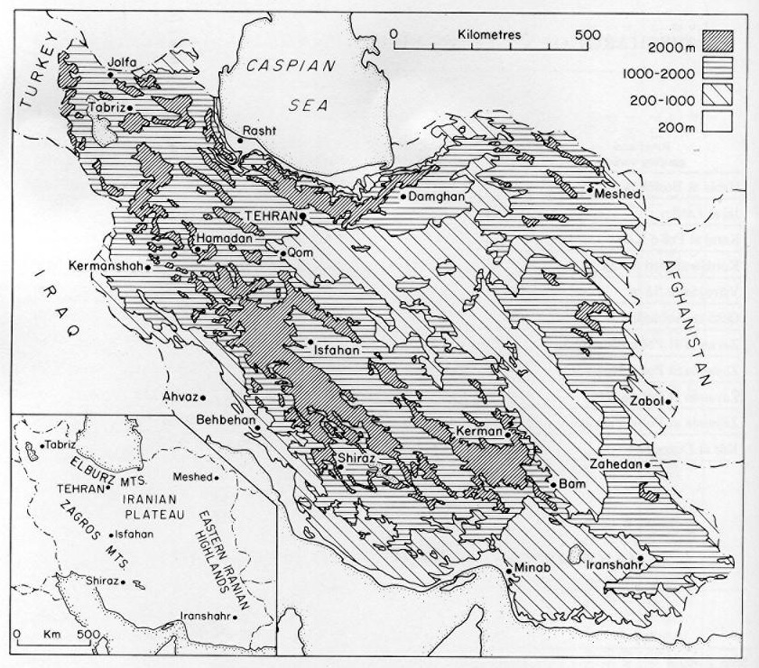
The Iranian plateau is a large area of inland (endoreic) drainage in central Iran bounded to the north by the Alburz mountains, to the west and south by the Zagros mountains, and to the east by a series of ranges referred to as the Eastern Iranian Highlands (Figure 1). The plateau is about 1,000 km in length from northwest to southeast and about 600 km in width. With the exception of a small area in the southeast it is at least 500 m above sea level, while along the margins in the north and west it attains heights in excess of 3,000 m. The general topography of the plateau is varied, but it is characterized throughout by upland blocks of solid rock, surrounded by large alluvial fans and alluvial plains. In the lowest parts of the plateau salt deserts (kavīr) are a common feature.
The Iranian plateau has a long history of human occupation (see Archaeology). Throughout history many settlements have been established on the plateau with the great majority located along alluvial fans and plains at the edge of the upland zones. Only in these peripheral zones can the two major needs of agriculture, flat land and water, be obtained in any quantity. The flat land is provided by the alluvial fans and plains and the water either from the rivers draining the highlands or from groundwater systems which are recharged by these rivers.
At present a surprisingly large number of major urban centers of Iran are located on the plateau. Of the fifty-nine towns with populations of more than 40,000 in 1976, twenty-two are situated on the plateau (Echo of Iran, Iran Almanac 1976, Tehran, 1976, p. 322). Among these are Tehran (4.4 million); Isfahan (800,000); Shiraz (380,000); Qom (170,000); Hamadān (150,000); Yazd (120,000); Qazvīn (110,000); and Kermān (110,000).
In 1976, the population of Iran was 34.1 million and growing at a rate of 3.0 percent per annum (Population Reference Bureau, Inc., World Population Data Sheet 1976, Washington, D.C., 1976). Estimates for the year 2000 A.D. suggest that the population may by then have grown to 67 million. The startling rise has put tremendous pressures on the available water resources. Exact figures on the population of Iran in the early 20th century are impossible to obtain. Estimates suggest a population of about 9.9 million in 1900 and about 14.6 million in 1940 (B. D. Clark, “Iran: Changing Population Patterns,” in Populations of the Middle East and North Africa, ed. J. I. Clarke and W. B. Fisher, 1972, p. 79). By the time of the first census in 1956 the population had grown to 19 million and a decade later, at the second census, to 25.3 million. These data show that the major phase of growth occurred in the period since 1940.
The natural watershed boundaries of the plateau do not coincide with the administrative boundaries of the census areas, and so it is difficult to estimate the number of people living on the plateau itself. Estimates made by the author using census and map data suggest that approximately 44 percent of the total population are inhabitants of the plateau. Most of these people are concentrated in the northwest and western parts of the plateau around the major urban centers of Tehran, Qazvīn, Hamadān, Qom, Isfahan and Shiraz. Population densities around the eastern and southern margins of the plateau are very low indeed, usually less than 5 people per square km.
Climate
Owing to its altitude the plateau experiences an extreme climate with scorching summer temperatures almost everywhere. In June, July, and August, mean daily temperatures rise to more than 30° C (see Table 1), and there are only a few upland areas on the margins of the plateau where mean daily temperatures fall below 20° C. Summer evatranspiration values are high (for figures, see G. Perrin de Brichambaut and C. C. Wallen, A Study of Agroclimatology in Semi-arid and Arid Zones of the Near East, World Meteorological Organization Technical Note 56, 1963, p. 27). Monthly values from June to August are of the order of 200 mm.
In winter mean daily temperatures aver 10° C are recorded in the extreme southeast, but in most of the area mean temperatures are generally between 0° and 10° C (M. H. Ganji, “Climate,” in Camb. Hist. Iran I, p. 221). Along the foothills of the Alburz and Zagros mountains mean daily temperatures fall to below zero. The growing season on the plateau attains values of more than 240 days in the lower central portions. However, in the higher peripheral zones where almost all the settlement is concentrated, the growing season is generally between 180 and 240 days in length (P. Beaumont, G. H. Blake, and J. M. Wagstaff, The Middle East—A Geographical Study, London, 1976, p. 450).
The Iranian plateau is an extremely arid zone, but is bordered to the north and west by what are in Middle Eastern terms well-watered zones. Almost all the precipitation which falls in Iran is brought by low-pressure systems moving east-southeast from the Mediterranean Sea. During the winter months these depressions cross the country, bringing rain which decreases in amount in both easterly and southerly directions; most of it falls in the Alburz and Zagros mountains, to the north and west of the Iranian plateau, respectively.
In summer, as the overhead sun moves northward, so too do the major depression tracks, leaving the Iranian plateau under the influence of stable, subsiding air masses; and virtually no rain falls there.
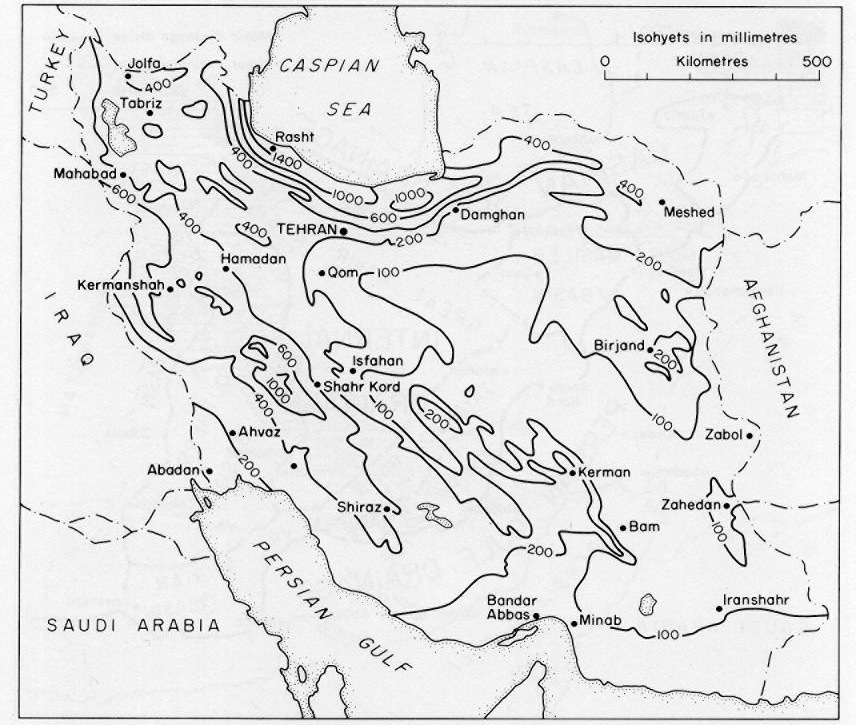
Over the most of the central part of the plateau, in the Dašt-e Kavīr and Dašt-e Lūt, annual precipitation averages less than 100 mm, making these among the most arid parts of the world (Figure 2; see Climatic Atlas of Iran, Tehran, 1975). Toward the margins of the plateau, especially toward the north and west, precipitation gradients steepen quite markedly; in the watershed of the Alburz and Zagros mountains, annual precipitation often exceeds 400 mm. However, these well-watered zones make up only a very small proportion of the total area of the plateau. Despite their small size, these zones of moderate precipitation have permitted the widespread human settlement of the region. The seasonal distribution of precipitation on the plateau is seen in Table 1. Most stations receive very low precipitation totals in the period June to October inclusive.
Relatively little information is available about rainfall intensities on the Iranian plateau. However, work on the rainfall record of Tehran, the capital, suggests that a fall of 55 mm/day is likely to be equalled or exceeded only once in 100 years during the winter season (A. H. Gordon and J. G. Lockwood, “Maximum One-day Falls of Precipitation in Tehran,” Weather 25, no. 1, 1970, p. 6). In terms of a return period of ten years, a daily fall of 35 mm can be expected.
Surface water hydrology
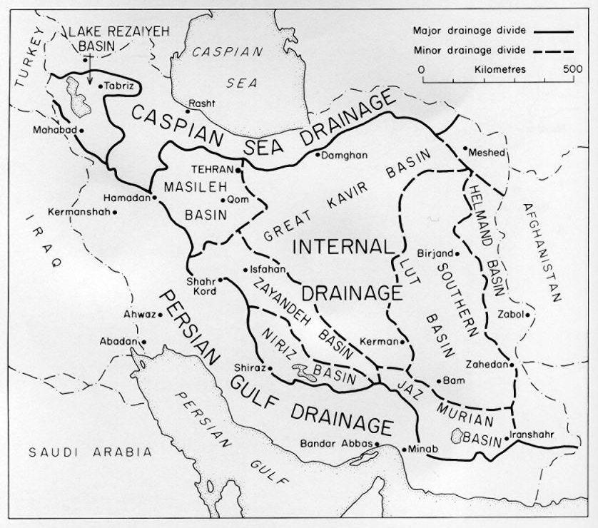
The drainage of the plateau is internal or endoreic. As a result of topographic irregularities six separate basins of internal drainage can be recognized (Figure 3; P. Beaumont, River Regimes in Iran, University of Durhum, Dept. of Geography, Occasional Publications, New Series no. 1, 1973, p. 20). By far the largest is the Great Kavir, which covers about one-third of the total area. Along the edge of the Zagros mountains a series of smaller basins are found.
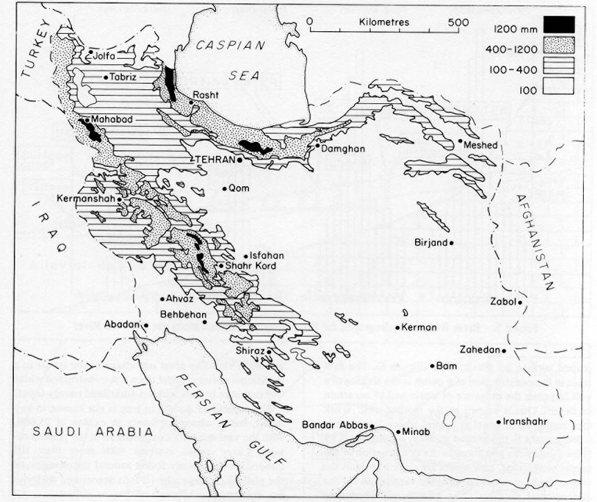
In the eastern and southern parts of the plateau annual water surpluses do not occur, and so streams only flow here for short periods following heavy rainfall. Perennial river systems are only found around the margins draining the inward facing slopes of the Alburz and Zagros mountains. These rivers, almost all of which are relatively small, are fed by water surpluses generated in the upland regions (Figure 4). These rivers carry considerable volumes of water onto the main part of the plateau. A characteristic feature of almost all these streams is that their regimes are dominated by snowmelt discharges. A large proportion of the precipitation during the winter months falls as snow. This water is held in the uplands in deep snowfields until late spring or early summer, when temperatures begin to rise. The snowmelt releases vast volumes of water into the river systems around the northern and western margins of the plateau, producing extremely well marked discharge peaks in March, April, and May, at a time when monthly precipitation totals are declining (J. S. Hopkins, “A Study of Snowmelt Floods in a Mountainous Catchment Using Limited Meteorological Data,” Meteorological Magazine 101, 1972, pp. 221-28).
Among the southern slopes of the Alburz detailed discharge records are available for four of the major river systems. Three of these, the Jāǰ-rūd, the Karaǰ, and the Kordān, have maximum discharges in late April to mid-May, while the Habla attains its peak between late March and mid-April (see Table 2). The Jāǰ-rūd and the Karaǰ, although they possess drainage areas only about 700 square kilometers above the gauging stations, have remarkably high annual discharge values of 256 and 385 million cubic meters respectively. As a result of these large discharges the runoff values for each square km are extremely high.
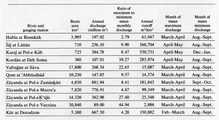
Information is also available for four rivers—the Vafreḡān, Qom-rūd, Zāyanda-rūd, and the Ḵorramšahr, which drain the Zagros mountains. Owing to the less precipitous nature of the Zagros when compared with the Alburz, these rivers tend to have larger drainage basins. However, as a result of the lower precipitation totals throughout the Zagros, the runoff rates for each square km of drainage basin are much lower on average than those recorded in the Alburz.
Of particular interest and importance is the Zāyanda river, on which the city of Isfahan is located. This river, unlike most others, has four gauging stations in its basin, which permits a study of discharge variations along its length (Table 2). In its upper reaches above Zamānḵān Bridge, the Zāyanda-rūd is a typical Zagros stream. It rises high on the flanks of Zard Kūh (4,548 m) and then flows eastward toward Isfahan. Owing to the high altitude in this part of the basin, snowfall is of great importance, and the regime of the river reveals a very marked snowmelt discharge peak in March-April. The average runoff in this part of the basin is 182,000 m3/km2. At each of the gauging stations below Zamānḵān Bridge the annual discharge in absolute figures declines markedly. This is the result of a number of natural and man-made conditions. The natural factors are evaporation losses from the water surface, and more importantly percolation into the river bed gravels as the flood plain begins to widen. This percolation water is not, of course, lost to the hydrological system, as it provides natural recharge of the groundwater reserves.
The most important man-induced water losses are the result of irrigation and associated evapotransportation. The main area of irrigation in the basin of the Zāyanda river begins downstream from the Mazraʿa Bridge and reaches its peak in the stretch about 25 km above and below the Ḵᵛāǰū Bridge. The Ḵᵛāǰū Bridge is situated in the center of Isfahan. By the time the river reaches Varzāna Bridge, just upstream from the salt desert known as the Gāv Ḵūnī, the annual discharge value dropped to 89 million m3—almost exactly one tenth the discharge recorded at the upstream gauging station of Zamānḵān Bridge. To what extent the man-induced water losses from the basin account for the spectacular decline in discharge along the Zāyanda river is uncertain owing to lack of detailed data. However, it is possible that irrigation accounts for at least 50 percent of the water losses.
Another fascinating feature of the Zāyanda river is the fact that in a downstream direction a greater proportion of the total flow is concentrated in the months of maximum runoff (Figure 5). For example at the Zamānḵān Bridge the peak flow during April represents only 17.5 percent of the total discharge, whereas at Varzāna Bridge it represents 39.5 percent. This illustrates that only during flood conditions in April and May do significant quantities of water pass down the total length of the river system to reach the salt desert of the Gāv Ḵūnī.
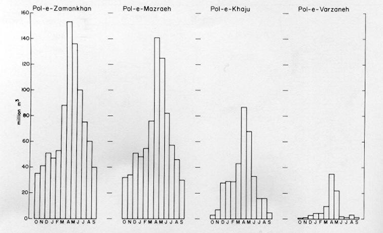
Conditions on the Zāyanda river have changed considerably since the construction of the Shah ʿAbbās dam (see Dam Construction in Iran, Plan Organisation, Bureau of Information and Reports, Tehran, n.d.). The purpose of the dam is to store the spring and early summer floodwaters of the river so that the late summer water demands can be met more efficiently. Since the dam was completed in the late 1960s, the height of flood flows downstream from the dam has been considerably reduced, and relatively little water now runs out into the salt desert.
To summarize the surface-water hydrological pattern of the Iranian plateau, one can note that the high runoff values associated with the Alburz and Zagros mountain zones grade off to virtually no runoff at all in the center of the plateau. However, during the late spring and early summer months, especially during years with high winter snowfalls, large quantities of water can flow down the many river systems fringing the plateau to form extensive shallow lakes in the lowest parts of the large basins. By late summer the water and salt mixtures which form the characteristic surface crust of the kavīr or salt desert regions (see D. B. Krinsley, “Geomorphology of Three Kavirs in Northern Iran,” in J. T. Neal, ed. Playa Surface Morphology; Miscellaneous Investigations, USAF Office of Aerospace Research, Environmental Research Papers no. 283, pp. 105-30).
Groundwater
Groundwater is a particularly important aspect of the hydrological cycle on the Iranian plateau. The groundwater reserves, like the surface water, are recharged mainly from precipitation which falls on the adjacent highland areas and then runs off toward the plateau (A. Issar, “The Groundwater Provinces of Iran,” Bulletin of the International Association of Scientific Hydrology 14, 1969, p. 94). At the edge of the foothills of the Alburz and Zagros most of the landforms are alluvial fans and plains made up of sand and gravel. Water infiltration rates into the alluvial deposits are high, and it is in these areas on the periphery of the plateau where almost all of the groundwater recharge takes place.
Once the water has entered the alluvial aquifers it flows down the hydraulic gradient, usually towards the central part of the enclosed basins. In general the water table, that is, the uppermost surface of saturated strata, tends to be deepest in the recharge areas along the foothills, where it can occur at depths of 20 to 200 m (P. Beaumont, “A Traditional Method of Groundwater Extraction in the Middle East,” Groundwater 11, 1973, pp. 23-30). Towards the middle of the basins the water table is found at decreasing depths, and in the center of some of them it even intersects the ground surface to produce areas of standing water. In nearly all the major basins of the plateau groundwater quality decreases towards the center of the basin, as a result of a marked increase in salt content (R. Ighanian, “Geochemistry of Groundwaters in Iran,” in Methods and Techniques of Groundwater Investigation and Development, ECAFE/UN Water Resources Series, no. 33, 1967, pp. 147-50).
Until very recently all of the settlements of the plateau region have been primarily dependent upon agriculture for their livelihood. In nearly all cases the lack of adequate precipitation has meant that cultivation has only been possible with the aid of irrigation. The traditional irrigation systems, which developed using both surface and groundwater resources, have often been exceedingly complex (P. Beaumont, “Water Resource Development in Iran,” Geographical Journal 140, 1974, p. 422). Surface water has been exploited by the use of unlined canals dug by hand in the alluvial material. The largest canals in any irrigation system can be 5 m or more in width at the point where they abstract water from the natural water source. However, these major canals soon divide into a series of small canals with average widths of around 0.5 m which convey the water to the individual fields of the cultivator. Water is usually led into the field either along furrows or by flood irrigation by digging away a portion of the bank of the irrigation channel. When a field has received sufficient water, the breach in the canal bank is stemmed and the water led off elsewhere.
A feature of these traditional irrigation systems is the absence of separate drainage canals. Although in some gentle gradient areas salination of the soil can be a serious problem, it is usually avoided by flushing out the salts into the canals, which thus serve both irrigation and drainage functions.
Until recently the groundwater resources of the Iranian plateau have been developed almost exclusively by annual engineering constructions known as qanāts. These are gently sloping tunnels which lead water from below the water table to the ground surface by gravity flow (Figure 6). The first stage in the construction of a qanāt is the sinking of a well to prove the presence of water and to ascertain its depth. This is known as the mother well. Work then begins on a tunnel at a point where the water is to be brought to the ground surface. All digging is by hand using picks and shovels. As construction of the tunnel progresses, new shafts are sunk to permit the extraction of spoil and to provide ventilation for the underground workers. The tunnel will eventually intercept the water table, but construction continues beyond this point, as it is only in this part where water actually flows into the tunnel. The water bearing sections of qanāts vary in length from about 100 m to distances of more than 1 km.
The lengths and depths of qanāts vary widely throughout the country according to local environment conditions such as surface gradients and the depths of the water table. From an analysis of qanāt systems from all over the Iranian plateau it has been found that most qanāts are less than 5 km in length, though some around Kermān are more than 50 km long (P. Beaumont, “Qanat Systems in Iran,” Bulletin of the International Association of Scientific Hydrology 16, 1971, p. 43). The depths of mother wells also show wide variations. Most range between 10 and 50 m in depth, though some from the eastern part of the plateau around Gonābād have recorded depths of more than 250 m. This fact clearly emphasizes the high value placed on water as a resource to warrant the construction of such deep qanāts.
Considering the huge investment of capital which the construction of a qanāt involves, the water discharge of most of them is surprisingly small. In most cases average discharge figures range between 10 and 80 m3/hr. The great advantage of the qanāt in a traditional society is that once it is constructed water will continue to flow without additional energy input.
The number of qanāts in Iran is not known in any detail, but is almost certainly in excess of 25,000, with the vast majority concentrated in the plateau region. Large qanāt systems with more than 100 qanāts are commonly found around the margins of the plateau on large alluvial fans associated with rivers draining the Alburz and Zagros mountains. Almost all these systems are found in zones with precipitation totals between 100 and 300 mm where cultivation is impossible without irrigation. Although groundwater is a major source of irrigation water in these areas, surface water supplies are also always utilized when available.
One of the largest qanāt systems on the plateau used to exist on the Varāmīn plain, some 40 km southeast of Tehran. Before 1955 more than 250 qanāts were in use and supplied up to 40 percent of irrigation water needs of the plain. From the mid-1950s onward pumped wells were introduced to the Varāmīn plain and the patterns of groundwater extraction changed considerably. During the mid-1960s groundwater, provided by wells and qanāts, was supplying up to 60 percent of the irrigation needs in dry years. Continued pumping from the wells, however, associated with a dry spell lasting a number of years, caused the water table on the plain to fall markedly. In turn this reduced the discharge from the qanāts, and many ceased to flow completely, causing severe social and economic problems (P. Beaumont, “Qanats on the Varamin Plain, Iran,” Transactions of the Institute of British Geographers 45, 1968, pp. 167-79).
Water resource development
In an attempt to solve some of the water resource problems of the 1960s, the government decided to nationalize the country’s water resources. This was achieved with the enactment of the Nationalization of Water Resources Bill of July, 1968. One of the most important features of this act was that the future development of all water resources would be supervised and controlled by the Ministry of Water and Power, with permits required before new water resources could be developed.
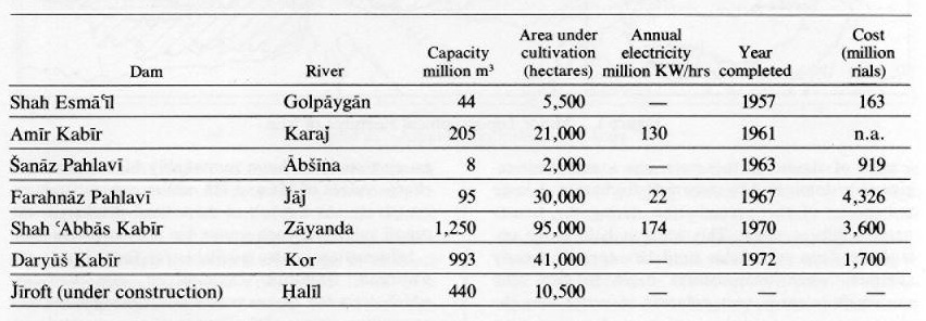
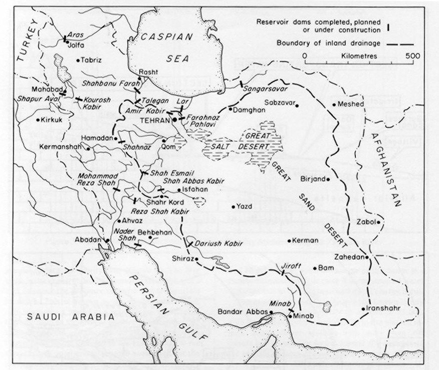
A major feature of development planning in Iran over the last 20 years has been the construction of large reservoir dams and associated irrigation projects. The first dams were built during the Second Development Plan (1955-62). By 1976 twelve major dams have been completed and four others were under construction. The total investment on the completed structures has been more than 30 billion rials. This does not include investment on associated irrigation facilities. Of the twelve completed dams, six are on rivers draining into the basins of the plateau (Table 3, Figure 7). One of the dams under construction is also situated in the plateau region. The first dam to be built on the plateau was the Shah Esmāʿīl Dam on the Golpāyagān river near Aḵtovān. This is an earth dam, built for irrigation purposes, which brought 5,500 hectares under cultivation. A much larger dam is the Karaǰ (officially the Amīr Kabīr) Dam on the Karaǰ, opened in 1961. This concrete multipurpose structure provided water for irrigation some 21,000 hectares on the Karaǰ plain and for supplying water (144 million m3/year) and electricity to Tehran. East of Tehran the Jāǰ-rūd Dam had the same objectives; water to irrigate 30,000 hectares of the Varāmīn plain was made available, as well as water (80 million m3/year) and electricity for Tehran.
The much smaller dam, formerly called Šahnāz, is unusual insofar as it was a single-purpose construction to supply much needed domestic water supplies for the growing city of Hamadān. On the Zāyanda river the Shah ʿAbbās Dam was completed in 1970, a reservoir of 1,250 million m3 with the aim of supplying domestic, industrial, and agricultural water supplies for the whole of the Isfahan basin. Its three generators also produce 174 million kilowatt hours each year. The final dam, the Dāryūš Kabīr on the Ḵorramšahr river, was built to provide irrigation water for 41,000 hectares in the Marvdašt area. Water from the dam is also used for domestic and industrial purposes in the city of Shiraz, 100 km to the south.
During the Fourth Development Plan (1968-73) and the Fifth Plan (1973-78) it became obvious that the major water resource problems in Iran were associated with the supply of water to the rapidly growing urban areas. Nowhere was this more urgent than in the two largest cities of the plateau, Tehran and Isfahan. In Tehran the population grew from about 210,000 in 1922 to an estimated 4.4 million in 1976. This phenomenal rate of growth has severely strained the water supply systems of the city. Initially water was supplied from qanāts to the north of the city. During the 1920s an aqueduct was built to bring water from the Karaǰ river to the west, but by 1950 these supplies were fully committed, and work began on the Karaǰ and Jāǰ-rūd dams. By the early 1970s it became evident that these schemes were not enough, and an even more ambitious project was begun. This necessitated the damming of the Lār river, which flows into the Caspian, and the diversion of its waters through a 20 km long tunnel underneath the crest-line of the Alburz. The water will then enter the reservoir behind Jāǰ-rūd Dam before being pumped along the existing pipe networks to Tehran. Recent calculations, however, have shown that this project’s extra 180 million m3/annum will only supply the needs of Tehran until the early 1980s, when a new scheme will be needed. In 1978 plans were already being evaluated for a dam on the Šāh-rūd, a tributary of the Safīd-rūd, which would be able to supply Tehran with extra water.
Information on water use in Tehran for 1973 reveals wide variations. In poor areas of high density housing the daily per capita use of water varies between about 45 and 75 liters. In contrast, in the more affluent northern parts of the city per capita water demand ranges from 120 to as high as 500 liters per day. There seems little doubt, however, that the demands of the poorer sections of the community are likely to increase over the years to about 100 liters/person/day. As Tehran grows and the per capita use of water increases as living standards rise, ever greater pressures are being put on available water and other resources around Tehran. Inter-basin transfer of water has already been used to supply Tehran with water, and it seems likely that by the end of this century water will have to be transported at least 150 km to supply the capital. Such schemes will obviously be expensive and will mean that water prices, which have already increased fourfold in the last few years, will increase even more.
Conclusion
The water resources available on the Iranian plateau are meager, and the water supply position has reached a critical situation, especially with regard to the larger cities such as Tehran and Isfahan. Already these cities have had to resort to the inter-basin transfer of water, conveying large quantities of water from rivers beyond the limits of the plateau drainage systems onto the plateau itself. Given the scarce water resources of the plateau it seems inevitable that this procedure will have to continue in the future as other urban centers find that their local supplies are insufficient for their growing needs. As more of these projects are implemented, the costs of water will have to rise, possibly to such a degree that it may prove difficult for the industrial consumer who uses large supplies of water in his manufacturing process to compete with other firms situated in parts of the world where water resources are more abundant and cheaper. It also seems likely that irrigated agriculture will become less important as it becomes necessary to divert water to supply the needs of the growing urban populations.
For water resources and hydrology of the rest of the Iranian regions see Hydrology; see also Ābyārī, Afghanistan (Geography), Azarbaijan, Central Asia, and Ḵūzestān.
Bibliography
Given in the text.
Table 1. Climatological Stations on the Iranian Plateau
Table 2. Discharge of Selected Rivers on the Iranian Plateau
Table 3. Major Reservoir Dams on the Iranian Plateau
Figure 1. Major Topographical Features of Iran
Figure 2. Annual Precipitation of Iran
Figure 3. Major Drainage Basins of Iran
Figure 4. Annual Water Surplus (Precipitation- Evapotransportation) of Iran
Figure 5. River Regime Hydrographs for Four Gauging Stations along the Zāyanda River
Figure 6. Cross-Section and Plan of a Qanāt
Figure 7. The Major Reservoir Dams of Iran