


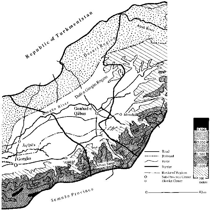
The city of Gonbad-e Qābus (now referred to officially as Gonbad-e Kāvus) is the administrative center of the sub-province (šahrestān) of the same name and the urban center of the Turkman tribal area in northern Persia. This sub-province is located in the eastern part of the province of Golestān and is bounded by the Republic of Turkmenistan in the north, the Alborz mountains and the province of Semnān in the south, the sub-province of Minu-dašt (a district, baḵš, of the Gonbad-e Qābus sub-province until 1997, when the Golestān Province was formed) in the east, and the sub-province of ʿAliābād in the west.
The sub-province of Gonbad-e Qābus (Map 1) covers an area of 7,795 km², which may be divided into four natural zones: (1) The northern zone, which, except for the banks of the river Atrak, almost entirely consists of barren hills and highlands; the settlements are few and far apart. The southern slopes of the highlands offer good pasture for local cattle. (2) The central zone, the eastern half of which is covered by vast rice-fields, is a barren desert in its western half. (3) The slopes of the Alborz zone, in which all the cities and most of the settlements are located, form a fertile water basin. (4) The southern zone entirely consists of mountains. In the southern part of the sub-province, up to the north of the city of Gonbad-e Qābus, winter is relatively cold and summer is warm and humid and the rainfall is much more considerable than in the northern part of the sub-province. The north and northeastern parts of the sub-province, which extend to the border of Turkmenistan, have much less rainfall, cold winters, and temperate summers (Mohandesin-e Mošāwer, II, p. 2).
The developments that occurred in the region of Gonbad-e Qābus and Dašt-e Gorgān in the Pahlavi era drastically changed the life of the people and landscape of the whole region. The Reżā Shah era (1921-41) was marked by a number of developments with significant impact on political, social, and economic life of the region in the remaining part of the 20th century. Major changes included: (1) The establishment of security, disarming the Turkman tribes and forced settlement of certain Turkaman clans in the newly reconstructed city of Gonbad-e Kāvus; (2) economic interests of the shah in the area and the appropriation of the entire region into the crown lands (Pahlavi Property Administration (PPA), Edāra-ye amlāk-e Pahlvi;); (3) the development of cash crops and mechanized farming by and (4) the development of roads and, above all, the construction of the Trans-Iranian Railway system connecting the region via Bandar-e Torkaman (then Bandar-e Šāh) to Tehran and the Persian Gulf port of Ḵorramšahr.
Mechanized farming, which was initiated in the 1930s by the Pahlavi Property Administration using some 20 tractors and combines, developed further in the 1940s-60s by dozens of large and middle-sized mechanized commercial farmers. The increasing investment and activities of modern farms and agro-industries in this period era induced drastic changes in the life of the people and turned the province into the most prosperous area in the Caspian region (Okazaki, pp. 7-51; Ashraf, pp. 7-8; for a detail account, see gorgān v ii, the Pahlavi Period).
The old city was rebuilt under Reżā Shah in a somewhat monotonous grid-scheme. At the same time, however, the reconstruction of the town marked the beginning of a steady, though modest, growth. The town had developed out of a permanently occupied post of the Ātābāy Turkman tribes, and Reżā Shah forced other Turkman tribes to settle in or near Gonbad-e Qābus. The Jaʿfarbāy tribe was the first to be settled, followed by other Turkmans such as the Yomut, Taka, etc. To this day the Turkmans constitute more than half of the city’s population. A sample survey of the ethno-linguistic distribution of the families living in the city quarters in 1983, showed that the Turkmans constituted 52 percent of the sample, Persian speaking residents 31 percent, Azeri speaking people 9 percent, Sistānis approximately 4 percent, and others the remaining 4 percent (Naẓari, p. 30).
The present urban structure of Gonbad-e Qābus with its distinct ethnic quarters is indicative of the ethnic configuration of its population. The first quarter, consisting of a strait extending from the northwestern corner of the city to its southwestern, is inhabited primarily by Sunnis of Turkish, Afghan, Cossack, and Zāboli descent. The structure of this neighborhood is urban-rural with low density buildings. The second quarter is located in the northeast of the town with primarily Shiʿite inhabitants. The low-income inhabitants of this section of the town are mainly Azarbaijanis who work as laborers in the local industries, small shops, and low-ranking government jobs. The third quarter is located in the southeastern part of the city. The inhabitants are primarily Persian speaking and work as high ranking government employees, merchants, army officers, professionals, and landowners. The urban structure of this quarter is well arranged. The fourth quarter is located in the center of the town and constitutes its oldest quarter. Inhabitants of this quarter have lived there for generations, with over one-half being Turkman. The plan of this quarter is of a checkerboard pattern (Mošāwerān-e ṭarḥ o ebdāʿ, VIII, p. 20).
Due to its location on the banks of the Gorgānrud River and the construction of the Vošmgir Dam (named after the Ziyarid ruler Qābus b. Vošmgir), irrigating approximately 20,000 hectares of fertile land in the Dašt-e Gorgān, Gonbad-e Qābus has turned into a major development center for agricultural production in northern Persia. Its population has increased greatly since the Revolution of 1978-79. Present-day Gonbad-e Qābus is a thriving city with special importance as an administrative and educational center for the Turkman population as well as an industrial center, focusing on the processing of agricultural products, and containing large cotton mills and a big flour-factory. Turkman carpet manufacturing and trading is also a major activity in the city. In 1986 there were thirty-seven industrial establishments in the town with over ten employees.
Bibliography
Ahmad Ashraf, Neẓāmhā-ye bahra-bardāri-e kešāvarzi dar Irān, a monograph, Plan and Budget Organization, Institute for Regional Planning and Training, Tehran, 1353 Š./1974.
Eckard Ehlers, “Die Turkmenesteppe in Nordpersien und ihre Umrandung: Eine landeskundliche Skizze,” in Strukturwandlungen im nomadisch-bäurlichen Lengensraum des Orients, erdkundliches Wissen, Geogrrafische Zeitschrift 26, Wiesbaden, 1970, pp. 1-51.
Manṣur Gorgāni, Eqteṣād-e Gorgān o Gonbad o Dašt, Tehran, 1350 Š./1971.
Horst Kopp, Städte im östlichen iranischen Kaspitiefland, Erlanger Geographische Arbeiten 33, Erlangen 1973.
Mohandesin-e mošāwer-e ṭarḥ o meʿmāri, Ṭarḥ-e jāmeʿ-e šahrestān-e Gonbad-e Kāvus, Tehran, 1375 Š./1996.
ʿAbd-al-Ḥamid Naẓari, “Maḥalla-bandi-e qawmi-e šahr-e Gonbad-e Kāvus,” Rošd-e āmuzeš-e joḡrāfiā 11/43, 1997, pp. 29-34.
Shoko Okazaki, The Development of Large Scale Farming in Iran: The Case of Gorgan, The Institute of Asian Economic Affair, Tokyo, 1968.