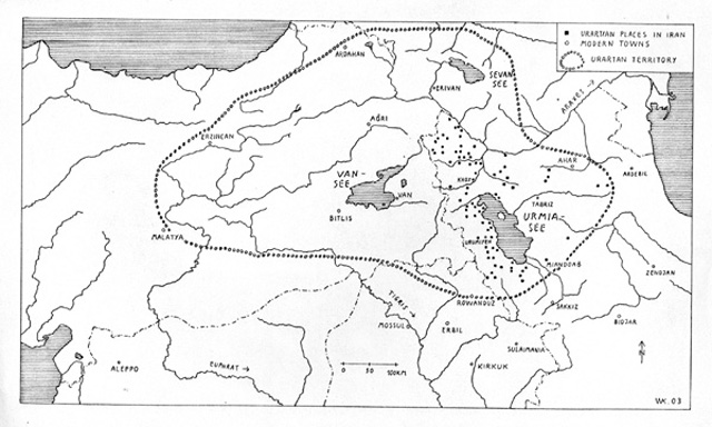


URARTU IN IRAN. The territory of the ancient kingdom of Urartu extended over the modern frontiers of Turkey, Iran, Iraq, and the Republic of Armenia. Its center was the Armenian highland between Lake Van, Lake Urmia, and Lake Sevan. Urartu extended from the Euphrates in the west 850 km to the region west of Ardabil in Iran, and 500 km from Lake Çildir near Ardahan in Turkey to the region of Rowāndiz in Iraqi Kurdistan (FIGURE 1).
Historical outline. Urartu (Uruatri) is first mentioned as “Nairi countries” in Assyrian sources in the time of Salmanasser I, 1274 B.C.E (Salvini, pp. 18 ff.). In the 9th century B.C.E., it is mentioned (in Urartian sources: “Biainili”) as a confederacy of tribes in the region of Lake Van and in the upper valley of the River Zāb. Gradually, the tribes expanded into the Anatolian mountains between the upper Euphrates and Lake Urmia. They achieved political unity in the middle of the 9th century B.C.E. King Sarduri established the Urartian kingdom and began to construct a capital city, Tuşpa (Van Kalesi). During the reign of Ispuini in the last quarter of the 9th century, the Urartian expansion began into the region of Urmia and the Urartian ruler Menua built up a powerful state extending in the east up to Mannea.
The several regions of Urartu were overseen by provincial governors and the territory was secured by fortified residences and smaller castles, which were situated along the connecting roads. At the beginning of the 8th century B.C.E. Argishti I occupied the plain north of Mount Ararat and the Araxes river with great cities like Erebuni (Arinberd) and Argishtihinili (Armavir). During the reign of Sardur II (760-30 B.C.E.), Urartu’s power in the Near East and its expansion into Transcaucasia reached its zenith, but it also suffered its first defeat against Assur. Rusa I (r. 730-14/13 B.C.E.) achieved greater power and exerted stronger Urartian influence in the mountain region of Armenia, but he was defeated by Sargon I of Assyria in his eighth campaign in 714 B.C.E. This was the end of his kingship, but not the complete end of Urartu. Argishti II (r. 713-690 B.C.E.), son and successor of Rusa I, expanded the country in the eastern regions up to Mount Sabālān (near Ardabil) after he reestablished žUrartian power. In this period the kingdom is referred to in the Old Testament as “Land Ararat” (2 Kings 19:36-37)—during the reign of Sanherib, king of Assur, 681 B.C.E. (extensive bibliography in Salvini).
Rusa II (ca. 685-45 B.C.E.), successor of Argishti II, founded additional fortresses to consolidate Urartian power, such as Rusahinili (Van-Toprakkale), Kefkalesi near Adilcevaz in eastern Turkey, Rusa-i-URU.TUR (Bastam [see BEṢTĀM, Iranian Azarbaijan]), and Teişebai URU (Karmir Blur, Armenia). These were necessary to protect the country against the Cimmerians and Scythians in the north of Urartu. But eventually these equestrian tribes defeated Rusa II in the middle of the 7th century B.C.E. Urartu vanished around 590 B.C.E. Its territory became a part of Media and finally of the Achaemenid Empire (the satrapy Armina) according to the inscription of Darius I (r. 522-486 B.C.E.) at Bisotun (see Salvini, p. 120).
Urartian archeological finds in modern Iran. There are 80 Urartian sites known in Iran, including castles, settlements, water channels and other water constructions, rock chambers, rock graves, stelae, rock inscriptions, and building inscriptions. Surveys and excavations in Bastam, Qalʿa-ye Esmāʿil Āqā, west of Urmia and in Sangar, west of Māku have brought to light ceramics (sherds), small finds, and tablets with important cuneiform texts; but, unfortunately, these researches were interrupted after the Islamic Revolution of 1979. The results so far achieved in the provinces of West and East Azarbaijan give a very instructive picture of the concentration of Urartian settlements north and west of Lake Urmia (FIGURE 1), especially in the fertile plains around Qarā Żiā-al-Din, Ḵoʾi, Salmas, Urmia, and Ošnawiya, west of Lake Urmia. Between the concentrated settlement regions, the presence of castles and road stations indicate the old Urartian roads, which never lost their importance in the later course of Azarbaijan’s history.
Most impressive are the Urartian architectural remains with their different building forms and ground plans, mainly as castles and larger fortresses (FIGURE 2). They range in size from small, mostly rectangular castles or road stations to the extended fortification systems of large settlements (Kleiss, 1983, pp. 283-90) such as Rusa-i-URU.TUR (Bastam). In some cases it is possible to infer the function of a site from its size and topographical situation; thus one can distinguish small road stations, larger castles linked to settlements or important crossroads, fortified, medium-sized settlements serving as local district centers, and—as apparently at Bastam (Kleiss, 1988c)—an administrative center of a larger region with a temporary royal residence. Places like Bastam had strong fortresses, located in topographically strategic positions, a prestigious religious sanctuary, a supply depot for food and other necessities, and military barracks and stables. Outside the fortress was a village (vicus) for artisans and merchants.
Urartian castles and fortresses are mainly situated in mountainous regions and are therefore constructed on rock cuttings. These rock cuttings or rock steps are made according to the exact plan of the building, and their outline reveals the line of the former walls of the destroyed building (Kleiss, 1976b, pp. 28-44). This foundation system, used already by the Hittites (Kleiss, 1991b, pp. 128 ff.), was later also applied by the Achaemenids in Persepolis (Kleiss, 1971, pp. 69-76). Upon the rock cuttings and rock terraces, the walls made (without mortar) of larger and smaller stones are constructed as foundation for the mud brick walls of the upper parts of the buildings. The mud bricks have a size of 50 x 50 x 12 cm. Risalites (projections) divide the front of the wall into regular segments, more for aesthetic than for structural or functional purposes (Kleiss, 1976b, pp. 28-44).
One difference between “old Urartian” fortifications in Qalʿa-ye Siāh from the 9th-8th centuries B.C.E. (Kleiss, 1976b, p. 35, fig. 18) and “new Urartian” fortifications in Qiz-Qalʿa Evoḡlu (ibid., p. 33, fig. 13) is that the former type of castle shows a strong geometrical design with a sequence of risalites between massive rectangular towers, without regard for the topography of the site. From the 7th century to the end of Urartu, there are no massive rectangular towers but only small risalites in the walls, which follow the best topographic contour.
In most cases, the strong stone and mud brick walls constitute the substructure for several upper stories, as indicated by Urartian bronze building models (Kleiss, 1976b, p. 29, fig. 5) and reliefs from Adilcevaz in Turkey (ibid., p. 43, fig. 34). Urartian gate constructions vary from simple passages through the wall, in smaller structures, to strongly fortified towers and gatehouses (ibid., p. 37, figs. 20, 21).
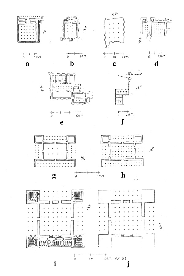
The hall is an important part of Urartian architecture. It was taken over from Hittite buildings in Büyük Kale in Boğazköy, Turkey (Naumann, p. 431, figs. 571, 572), developed by the Medes in Tepe Nuš-e Jān (Matheson, p. 127, fig. 36) and Godin Tepe in western Iran (Matheson, p. 142, fig. 45), and finally used in Pasargadae and in the apadana (OPers. apadāna) form in Persepolis and Susa (Kleiss, 1980, pp. 199 ff.). The “Burned Buildings” at ḤOasanlu show a connection to Urartian halls (Matheson, p. 98, fig. 28).
In contrast to the pre- and post-Urartian hall constructions, the Urartian examples mostly have a rectangular ground plan with three naves and two lines of pillars or columns. Halls with two naves or a square ground plan are the exception (Kleiss, 1976b, p. 37, figs. 20, 21). The Urartian hall buildings are divided into pillared and columned types; their functions varied, e.g., audience rooms, storerooms, barracks, and stables. The roofs are supported by pillars (ibid., p. 37, fig. 20).
A special type of ground plan is found in buildings that have rooms on all sides of a central courtyard. These can be in small Urartian sites like Čerāga-ye Amir (Kleiss, 1976b, p. 32, fig. 12) as standalone structures, as well as in greater fortresses and connected with other buildings, as in Bastam (ibid., p. 37, fig. 21, below). This Urartian court building form was used also in road stations, as in Tepe Dosoq (Kleiss, 1988b, p. 205, fig. 17), and it occupies a place in the line of development of the later caravansary.
The usual Urartian house had only a few small rooms or else several different rooms around a courtyard or a central room. It was enlarged or changed in the course of time (Kleiss, 1977a, p. 44, fig. 34). In the map of a settlement, one can observe that the orientation of the houses is based on the topography or on the direction of the prevailing wind, for instance, in the settlement of Besṭām (ibid., p. 40, fig. 30). The function of individual rooms as storerooms for large clay jars (pithoi), as kitchens, or as stables is mostly recognizable. A complex of four houses, connected one to the other in a line, was excavated in Karmir Blur, Armenia (Kleiss, 1988b, p. 198, fig. 9).
One of the most exceptional creations of Urartian architecture is the temple, usually consecrated to the god Haldi. We know some ground plans of the Urartian temple, all of the same square outline (Kleiss, 1988b, p. 206, fig. 18) with strong walls, a square cella, and a narrow entrance, mostly in form of a portal niche. The four corners of the building have broad risalites, and the length of the external walls vary between 14.20 m on a side, in Aznavur/Patnos, Turkey, and 9 m in Arinberd, Armenia. The temple of Toprakkale/Van has, in its four outer corners, traces of carved rock beds for foundation tablets (Erzen, pp. 383-414).
The square plan and the strong walls point to a tower-like structure, possibly with a flat tent-roof and similar to the Achaemenid towers at Naqš-e Rostam (see KAʿBA-YE ZARDOŠT) and Pasargadae (Kleiss, 1989, p. 268, fig. 2; 1967, pp. 278 ff.). The form of the roof of the Urartian temple is not clear—whether a flat roof or one with crenellations or four towers, which rise above the roof—but the supposition of a tower temple form is supported by depictions on Urartian reliefs and bronzes. The image of the temple on the Assyrian Musasir relief does not show a tower temple, but apparently a local form of the Haldi temple, with niches on the facade. Urartian temple towers mostly are built on terraces (Kleiss, 1988b, p. 209, figs. 21, 27); occasionally they are in a columned courtyard, as in Altıntepe in eastern Turkey (ibid., p. 208, fig. 20), or occur in a complex of buildings constructed later up against the original freestanding temple, as in Kayalıdere (ibid., p. 211, fig. 23).
Urartian rock architecture in the form of rock graves, rock reliefs, and staircase tunnels is another important aspect of Urartian architecture. In connection with Urartian sites there are a number of rock chambers, with the function of rock cut graves, in different sizes and arrangements. The most important examples are the so-called “king chambers” in Khorkhor at the hilltop fortress of Van-Kalesi (Piotrovskij, pp. 301 ff.). The largest rock chamber in Iran is Sangar near Māku (Kleiss, 1976b, p. 42, fig. 32). The larger examples have several small rooms around one bigger central room and—in a few cases—a rock-cut staircase outside the central chamber. The walls of the chambers have round-arched or rectangular niches. The form of the rock chambers is carried over into grave chambers, constructed in stone with several rooms and with niches in the walls, as in Altıntepe (Kleiss, 1976b, p. 42, fig. 33). Inside the walls of the Urartian castle of Qalʿa-ye Esmāʿil Āqā, west of Urmia, are two chamber graves, which were entered through shafts and could be closed by stone slabs. These also could have been cut in the rock by the Urartians (Kleiss, 1977b, pp. 67 ff.).
Also worthy of mention are large rock-cut terraces with rock niches for inscriptions and terraced open-air sanctuaries, like Meher Kapısı near Van (Salvini, 1995, pp. 143 ff.). Rock reliefs in connection with Urartian grave chambers are found in Eski Doğubeyazit (Huff, pp. 58-86; Salvini 1995, p. 163, fig. 8).
We do not know of any Urartian freestanding sculpture in stone, but there are some bas-reliefs, for instance a genius from the region of Evoḡlu in Iranian Azarbaijan (Calmeyer, p. 187, fig. 5). The door reliefs from Adilcevaz in Turkey (Salvini, 1995, p. 166, fig. 10) and a pillar- or column-base relief from Adilcevaz also show Urartian gods or genii and, in the background, Urartian fortification architecture (Calmeyer, p. 187, fig. 4). This shows in detail the construction of an Urartian defense system, and especially of towers (Kleiss, 1976b, p. 43, fig. 34).
One aspect of rock cutting the Urartians developed successfully was rock-cut step-tunnels, which descended inside a castle to a spring or river and also served as sally ports. Such tunnels are mainly in West Urartu on the western Euphrates, some in the region east of Lake Van, and so far one example in Iranian Azarbaijan at Qalʿa-ye Ḥaydari near Siāh Češma (Kleiss, 1976a, pp. 21 ff.). Steps were cut out, following the natural fissures in the rock; in Qalʿa-ye Ḥaydari, 29 steps are still visible, where the tunnel is not yet filled up with earth. The rest of it has not been excavated. Besides the use of such tunnels, the water supply in Urartian castles was also secured by cisterns cut into the surface rock, which caught the rainwater.
The Urartians carried on stock farming and also agriculture, for which they constructed a system of water channels. The most famous Urartian water channel is the so-called Menua channel (“Semiramis channel”), which served the area of the capital Tuşpa (Van). Constructed in the 9th century B.C.E., it is in part still functional (Salvini, 1995, p. 126, fig. 3). The channel is supported along the down slope by stonewalls (W. Kleiss, 1976b, p. 41, fig. 29). East of Van, the remains of several Urartian embankments still control the water reservoirs (Keşiş Gölü) for the town of Van. The dams were built with two or three parallel stonewalls with impermeable clay fill between them and sloped stone or clay reinforcement of the exterior sides. This construction system was taken over, slightly developed, by the Achaemenids in building their own protective dams.
In the 7th century B.C.E the Urartians also built walls along rivers to protect against high water, and outside the defensive walls of Verakhram the remains of pillars of an Urartian bridge across the river Aras (Gk. Araxes) are still visible (Kleiss, 1976b, p. 33, fig. 14).
Urartian bronzework can be divided into (1) objects cast in a mold, such as statuettes of figures seated on thrones, candelabra, decorative attachments, weapons, arrowheads, horse snaffles, and small bronze bells; and (2) objects made with thin plates of metal, such as shields and bronze belts (Salvini, 1976, pp. 53-60).
To seal correspondence, goods, boxes, and doors the Urartians used simple stamp seals as well as cylinder seals (Seidl, p. 61). Stamped clay bullae were abundantly used to seal packaged commodities of different kinds.
Urartian pottery is mainly earthenware and, to a lesser extent, red polished ceramic, so-called palace-ware, since it is found only in the larger, central Urartian sites. Urartian pottery is mostly monochrome ware made by potter’s wheel. Huge pithoi are found in the storerooms of fortresses such as Bastam (Kroll, pp. 62-63).
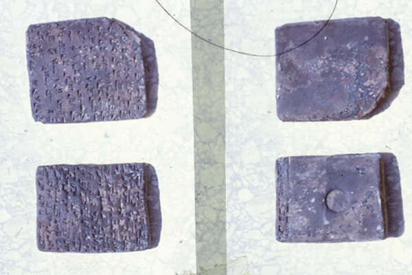
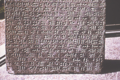
Cuneiform inscriptions have been found on clay tablets (FIGURE 3), cylinder seals, and bullae (Salvini, 1979, pp. 115 ff.); there are inscriptions on building stones, as at Bastam (FIGURE 4) and rock inscriptions, others on stelae and on clay vessels (ibid., p. 140, fig. 5).
Among the Urartian small finds is a gold-leaf wreath (5 cm in circumference) found at the southern gate of Bastam, obviously a relic of plundering when the Urartian fortress fell (Kleiss, 1977a, pp. 14, 17, fig. 7). The fragment is a garland of overlapping leaves, similarly attested by other Urartian sheet gold work (Kleiss, 1976b, table 6) and by bronzes, as on the so-called throne of Toprakkale (Salvini, 1995, p. 181, fig. 15). The object from Bastam may belong to a wooden piece of furniture.
Urartian influence. The Urartian influence on the Medes and Persians, indicated by the title of the rulers, “king of kings” in the Besṭām inscription (König, no. 129), which was used by the Achaemenids (OPers. xšāyaθiya xšāyaθiyānām), is shown especially in architecture and in construction details, as well as in hydraulic structures. In architecture the Achaemenids reused the Urartian knowledge of how to set building foundations on rocky ground by the preparation of rock cuttings and terraces, and how to erect mud brick walls directly on rock steps without a stone foundation, as can be seen in the upper castle of Taḵ-t-e Jamšid (Persepolis).
In the development of hall buildings (see FIGURE 5), Urartian architecture took over the motif of the pillared or columned hall from the Hittites in Boğazköy-Büyükkale; it is also used in the “Burned Buildings” in ḤOasanlu IV and in Armavir and Bastam. The hall, with two lines of pillars or columns, used as an audience room or perhaps as a stable (Bastam), is enlarged to three lines of pillars or columns in Median time in Tepe Nuš-e Jān, and brought to a square plan in Godin Tepe. The Achaemenids developed the hall progressively from the form of Dašht-e Gowhar near Naqš-e Rajab to the Apadana (OPers. apadāna) form in Persepolis and Susa (Kleiss, 1980, pp. 199-211).
The Urartian rock chambers influenced the Achaemenid rock graves in layout and in stonecutter techniques. The monumental scale of the Urartian rock cuttings and surface preparation for cuneiform inscriptions prepared the way for the Achaemenid monumental inscriptions, in particular that of Darius at Bisotun.
The Urartian temple, the temple tower, has influenced both the Achaemenid towers in Pasargadae and Naqš-e Rostam, and the form of blind niches was used by the Urartians and later by the Achaemenids.
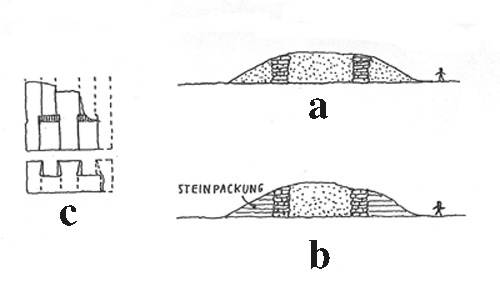
Finally, the Achaemenid technique of dam constructions is a heritage of the Urartians (FIGURE 6). In the area of Pasargadae, several dams were built as water reservoirs or to prevent floods. They are constructed in the same manner as the Urartian dams with two stonewalls and clay between them, but slightly strengthened with stone facings on both exterior sides. In a dam of about 20 m height near Didgān in Fars, stone water channels and locks are still in situ. The channel stones and those of the locks are joined with dovetail clamps (Kleiss, 1988a, pp. 63-68; 1991b, pp. 23-30; 1992, pp. 131-45). Thus, they are dated in the Achaemenid period.
Bibliography
P. Calmeyer, “Zu den Eisen-Lanzenspitzen und der Lanze des Ḫaldi,” in Kleiss, 1979, pp. 183-93.
A. Erzen, “Untersuchungen in der urartäischen Stadt Toprakkale bei Van in den Jahren 1959-61,” Archäologischer Anzeiger, 1962, pp. 383-414.
D. Huff, “Das Felsgrab von Eski Doğubayazit, Istanbuler Mitteilungen 18, 1968, pp. 58-86.
H. J. Kellner, Urartu, ein wiederentdeckter Rivale Assyriens, Ausstellungskataloge der Prähistorischen Staatssammlung München 2,Munich, 1976.
W. Kleiss, “Urartian and Achaemenian Tower Temples,” JNES 26/4, 1967, pp. 278-88.
Idem, “Die Felsabtreppungen von Persepolis,” MDOG 103, 1971, pp. 69-76.
Idem, “Zwei Plätze des 6. Jahrhunderts v. Chr. in Iranisch Azerbaidjan A. Die Bauten,” AMI, N.S. 9, 1976a, pp. 107-16.
Idem, in Kellner, 1976b, pp. 45-52.
Idem, Bastam/Rusa-i-URU.TUR, Führer zu archäologischen Plätzen in Iran I, Berlin 1977a.
Idem, “Urartäische Plätze in Iran. A. Architektur (Stand der Forschung Herbst 1976),” AMI, N.S. 10, 1977b, pp. 53-83.
Idem, ed., Bastam I: Ausgrabungen in den Urartäischen Anlagen 1972-1975, Berlin, 1979.
Idem, “Zur Entwicklung der achaemenidischen Palastarchitektur,” Iranica Antiqua 15, 1980, pp. 199-211.
Idem, “Gröβenvergleiche urartäischer Burgen und Siedlungen, Beiträge zur Altertumskunde Kleinasiens,” in Beiträge zur Altertumskunde Kleinasiens. Festschrift für Kurt Bittel, Mainz, 1983, pp. 283-90.
Idem, “Achaemenidische Staudämme in Fars,” AMI 21, 1988a, pp. 63-68.
Idem, “Aspekte urartäischer Architektur,” Iranica Antiqua 23, 1988b, pp. 181-215.
Idem, ed., Bastam II, Ausgrabungen in den urartäischen Anlagen 1977-78, Berlin, 1988c.
Idem, “Zur Rekonstruktion des urartäischen Tempels,” Istanbuler Mitteilungen 39, 1989, pp. 1-14.
Idem, “Urartäische Fundamentierungen,” in Bautechnik der Antike, Diskussionen zur archäologischen Bauforschung 5, 1991, pp. 128-30.
Idem, “Wasserschutzdämme und Kanalbauten in der Umgebung von Pasargadae,” AMI 24, 1991, pp. 23-30; AMI 25, 1992, pp. 131-45.
F. W. König, Handbuch der chaldischen Inschriften, Osnabrück, 1955-57.
S. A. Matheson, Persien, ein archäologischer Führer, Stuttgart, 1980.
St. Kroll, “Urartäische Keramik,” in Kellner, 1976, pp. 62-63.
R. Naumann, Architektur Kleinasiens, Tübingen 1971.
B.B Piotrovskij, Il regno di Van (Urartu), Rome, 1966.
Mirjo Salvini, “Geschichtlicher Abriss. Zur Sprache der Urartäer,” in Kellner, 1976, pp. 11-16.
Idem, “Die urartäischen Tontafeln aus Bastam,” in Kleiss, 1979, pp. 115-31.
Idem, Geschichte und Kultur der Urartäer, Darmstadt, 1995.
U. Seidl, “Urartäische Glyptik,” in Kellner, 1976, p. 61.
(Wolfram Kleiss)
April 7, 2008