


KANDAHAR
i. Historical Geography to 1979
The Kandahar oasis. South of Afghanistan’s central mountains, a broad alluvial cone, with a gradual slope of 900 to 1,000 m elevation, is formed by the confluence of one of the country’s main rivers, the Arḡandāb, and its tributary, the Tarnak. (The latter is fed by the Šorāb river on its right bank and by the Dori and Arḡestān rivers on the left bank.) The climate is semi-arid (164 mm annual rainfall at Kandahar), and the area offers a marked potential for development of irrigated farming, with use of either surface or underground canals (kāriz), and for population growth.
This oasis, bordered on the south by the sandy mass of the Rēgistān desert, extends for about 70 km from east to west and is 30 km wide at its broadest. Forming a continuous, irrigable soil, it is only slightly divided by rocky outcroppings. With an area of over 1,000 km2, it accommodates the densest rural population in southern Afghanistan, with about 260,000 inhabitants in 1979 (Grötzbach, 1990, p. 336). The 2006 estimate of the population of the city was 450,300 inhabitants.
The oasis clearly was destined to give rise to a major city that would control these rich lands with their grain fields, orchards, and gardens and manage the irrigation system they required. This urban center naturally had to be situated near the top of the alluvial cone, in the area where the Arḡandāb river runs down from the mountains. This site also provided a natural stopover on the southwest-northeast road through the foothills of the central mountains, and it soon formed a major traffic junction. From there a relatively easy road heads east to skirt the Rēgistān sands, then toward the southeast, leading to Quetta in Pakistan and beyond it, by way of easy passes across the Solaymān mountains, down to the lower Indus basin. This has long been one of the main paths of access to the Indian subcontinent, making it possible to avoid the very arid route along the coast.
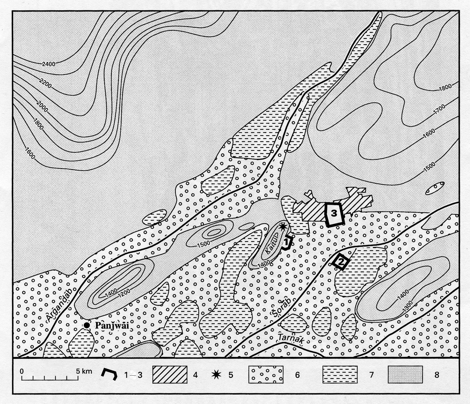
Ancient urban developments. The urban complex, or, rather, the successive urban complexes located in the oasis, certainly go back to very ancient origins, even to the beginnings of urban society. But the modern city is recent, only two and a half centuries old (see below). The question remains as to where the town or towns that preceded it were situated (Figure 1).
About 4 km to the southeast of present-day Kandahar extends a broad field of ruins, known today in the popular language as Šahr-e kohna (“the old city” = Pashto Zoṛ šār). The term indicates the place occupied by Kandahar up to the 18th century. The choice of this area was certainly due to the defensive possibilities offered by the rock ridge of Qaytul. Reaching about 1,400 m elevation, it dominates (by ca. 400 m elevation) the alluvial plain spread below it. A citadel was built at the top and secured the hill. This defensive site has the advantage of being the northernmost of the rocky outcroppings scattered along the plain, and the closest to the top of the alluvial cone; from it one can control and supervise the irrigation system. Qaytul may well have been the single focal point for all the major urban developments in the oasis from ancient times to the 18th century. However, this has not been proven, and the historical conditions under which there emerged the powerful city that existed there up to the end of the Middle Ages, and in modern times, remain obscure.
The city’s name—its origin, still controversial, and its history, complicated by its variations—is a related problem. From the Muslim period on, it has borne the name Kandahār (in Pashto; Pers. Qandahār), which appears for the first time in the works of the Arabic historian Aḥmad b. Yaḥyā Balāḏori (d. 892; ed. de Goeje, p. 434). Writing about the Arab raid in the region at the time of the Omayyad caliph Moʿāwiya (r. 661-80), he reports on the capture of a city located at the Indian border by the name of al-Qandahār. The Arab conqueror ʿAbbād b. Ziād renamed the city after himself to ʿAbbādiya, but the latter term disappeared quickly after his death (Fischer, pp. 192-93).
The name al-Qandahār is mentioned several times in this period by Yaʿqubi (fl. 2nd half of the 9th century; tr. Wiet, pp. ix, 90, 100, and 103). It appears again in the 13th century, and the literary tradition continued henceforth, although other names were occasionally applied to the city: Dawlatābād in the Mongol period, and Ḥosaynābād in 1737, after the name of the Gilzay (see ḠILZI) emir who possessed it during Nāder Shah’s (r. 1736-47) expedition. But there is the major difficulty that, for unknown reasons, the name Kandahar disappeared in the 11th-12th centuries. Sources of the Ghaznavid period never mention it, and the main center of the empire was evidently situated to the northeast at Ḡazni. As for the general region of Kandahar, Eṣṭaḵri (d. 951, q.v.; ed. de Goeje, p. 250) mentions two cities there: Tekinābād (whose name was to appear in the 18th century in European atlases; cf. Fischer, p. 191), and, at a day’s journey farther east, Panjwāy, which he described as the “principal city of al-Roḥḥaḡ” (that is, ancient Arachosia). Le Strange (Lands, p. 341) was not able to establish the position of the latter, but it may have been located in the modern village Panjwāy (Panjwāʾi; lat 31°31′22″ N, long 65°27′29″ E; Gazetteer of Afghanistan V, p. 380), which is situated 25 km southwest of Kandahar on the left bank of the Arḡandāb river, where significant ruins of the Islamic period are to be found (Fischer, pp. 191-92; p. 136, fig. 3).
What had happened to the city called Kandahar in the 9th century: could it have been on the site of Panjwāy, or was it already located on the site which today bears the name of Kandahar, and which may have been abandoned, from the 10th to the 13th century, for unknown reasons? Archaeology alone may provide the answers to these questions, by way of excavations on the sites of Qaytul and Panjwāy.
Archaeology also is needed to clarify the time before the 7th century, for which the study of names can only lead to conjecture. The origin of the name Kandahar remains debatable and subject to speculation. One should attach no importance to popular etymologies that derive the name from Eskandar (that is, Alexander the Great, based on the tradition of the Macedonian conqueror as founder of the city (discussion in Gazetteer of Afghanistan V, p. 262; cf. below). Several plausible, if unproven, interpretations have been offered by scholars. One might theorize that the origin of the name Kandahar is to be sought in that of the kingdom of Gandhāra (Old Persian Gandāra, Elamite Kan-da-ra: see refs., Hallock, p. 708), which occupied the lower basin of the Kabul river. H. W. Bellew (1880, pp. 22-23; cautiously, Caroe, pp. 169-70) conjectured that the name was applied to the entire region of present-day Kandahar by refugees fleeing the Hephthalite invasion in the 5th century CE. Another suggestion—of even earlier use of the name—is that “Kandahar” might derive from a hypothetical Greek town name *Gondophareia, after the name of the Indo-Parthian sovereign Gondophares (r. 20-50 CE), of whom coins have been found in the area (Marquart and de Groot, p. 269; Herzfeld, p. 63; Fischer, p. 210). The modern name has also been sought in the first part of Condigramma (the second member, grama, means ‘village’ in Sanskrit [see Mayrhofer, II, p. 353]), which is a town in Ariana (see ARIA) mentioned by Pliny (Natural History 6.25), and in the name of a district in Arachosia called Gandutava. The latter was the site of a battle between the Achaemenid satrap and rebels againt Darius I, as described in the king’s Bisotun inscription (DB 3.66; Agravala, p. 19; cf. Fischer, p. 205; see also ibid., p. 209).
In any case, there existed an important city on the western border of India from the 3rd century BCE on, as witnessed by a Greco-Aramaic inscription of the Indian emperor Aśoka (r. ca. 265–238 BCE) found on a rock one kilometer east of the northern part of Qaytul (Schlumberger et al., 1958). Even if the city on this site did not yet necessarily bear the name Kandahar, we cannot avoid the question of whether to identify it with the city of Alexandria in Arachosia (see ALEXANDRIA for references), which the Macedonian conqueror was said to have founded when he passed through the region. The question is complicated (Tscherikower, pp. 102-3; Fischer, pp. 194-99). In fact, the tradition regarding this “foundation” (or, more often, re-foundation) is recent. It was not mentioned in the older Alexander literature; the 3rd-century BCE geographer Eratosthenes recorded in Alexander’s itinerary “the city of Arachosians” (Strabo, 11.8.9), that is, the people on whom Alexander imposed a satrap on his way to Bactria (Arrian, 3.28). The names Alexandropolis, Alexandropolis metropolis Arakhosias, and Ellenis only appear in late texts: Isidore of Charax in the 1st century CE (ed. and tr. Schoff, p. 37), repeated by Stephen of Byzantium (fl. 6th century) and others. Attempts have been made to identify the Arachosian Alexandropolis with Kandahar (Schoff, p. 34), but the claim was by no means proved. At least the existence of the Aśoka inscription and the late classical tradition of an Alexander foundation indicate the impact of the introduction of Hellenism in this region at the time of the great conqueror. Further archeological work may help define the exact locations of the oldest urban centers in the Helmand region.
When the name of the city reappears in the 13th century, one can follow its subsequent evolution accurately. Yāqut (d. 1229; see Yāqut, IV, pp. 183-84), who wrote between 1218 and 1229, simply mentions it, reproducing the historical data of Balāḏori. However, already a century later, Ebn Baṭṭuṭa (d. 1368-69, III, p. 59) mentioned the city based on hearsay but described it as a great and rich city, to which the inhabitants of Ḡazni went to spend the winter (the winter climate being much milder at an altitude 1,000 m lower). The Mughal emperor Bābor (r. 1526-30) mentioned it several times, showing his interest in the city’s strategic situation and its important trade; he captured it in 1507, then lost it, before definitively receiving its surrender in 1522 (Bābor-nāma, tr. Beveridge, pp. 333-39; notes, pp. 431 ff.). According to the French traveler Jean-Baptiste Tavernier (d. 1689; see Tavernier, II, pp. 770-73), in the 1660s it was a “very eminent” city (p. 770), not only due to its advantageous site, which made it “the strongest city in all Persia” (ibid.), but also because it lay on the great thoroughfare traveled by all the caravans bound for India and back. At the time of Shah ʿAbbās I (r. 1587-1629), his Afghan governor of the city, ʿAli Mardān Khan, became extremely wealthy and maneuvered to retain his posting there, where the caravan traffic generated such lavish outlays (ibid., pp. 574, 770-72).
In the second half of the 17th century, however, the traffic appears to have suffered from the wars between the Safavids and the Mughals, who vied for its possession. With the help of the picture provided by Tavernier (Figure 2) and through modern surveys of the ruins, attempts have been made (Fischer, pp. 146-47) to restore the plan of the city. With its two citadels clinging to the mountain slopes to the west, the city below stretched east towards the plain; its main streets met at right angles, and there was a large central square; all was enclosed within powerful fortifications According to the estimated surface it occupied, the population might have amounted to almost 20,000 inhabitants.
This older city of Kandahar was captured and destroyed by Nāder Shah (r. 1736-47) in 1738 after a difficult siege of a year and a half. He built a new city, Nāderābād, at the place which, no doubt, had been his main camp during the siege. It was situated on the left bank of the Šorāb river, 4 km to the southeast of the ruins of the ancient city (and 3 km to the south of the present-day Kandahar; see a contemporary sketch-map in Arne). It already had a quadrangular shape, like the one that was to succeed it soon afterwards, certainly established on the basis of two main axes intersecting at right angles. Nāder Shah’s foundation was short-lived. It was abandoned after his death in 1747 and rapidly deteriorated, although it still continued to be marked on European atlases up to the late 18th century. Today it is no longer visible on the ground but appears quite distinctly on aerial photos (Fischer, pp. 147 and 211, figs. 3 and 6).
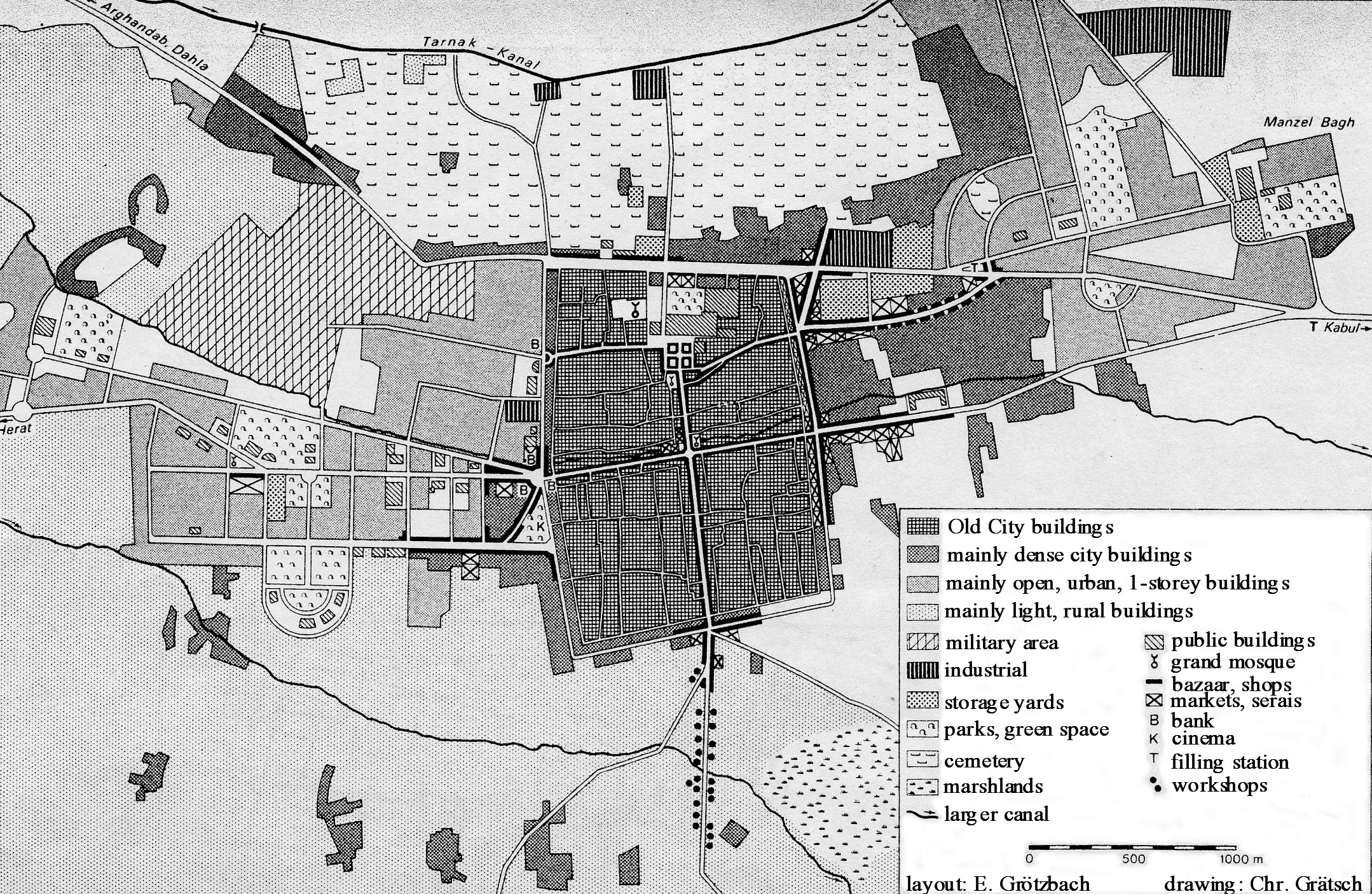
The capital of Aḥmad Shah Dorrāni: grandeur and stagnation. In the same year 1747, after the death of Nāder Shah, Aḥmad Dorrāni (r. 1747-73, see AFGHANISTAN X, pp. 547-48) was elected king, possibly at Nāderābād (Ferrier, 1858, p. 68). After reaching Kandahar, he received a symbolic investiture as “Shah of the Afghans” in the city’s Grand Mosque (ibid., pp. 69-70; cf. Singh, pp. 25-31). He followed the custom, frequent among Muslim sovereigns, of materializing the birth of a new dynasty by establishing a new capital, which he planned for north of Nāderābād. He wanted it to be grandiose, as witnessed by the name it received, Aḥmadšāhi “city of Aḥmad Shah,” which appeared on coins as mint name, with the epithet ašraf al-belād “noblest of cities” (Bosworth, p. 537; Singh, p. 367). This name remained in use until the name Kandahar was restored under the Bārakzay dynasty (on whom see AFGHANISTAN X, pp. 549 ff.) in the early 19th century (Fischer, pp. 148 and 211). It was built on a trapezoidal plan, roughly square, with the sides measuring 1,064 m on the north, 1,655 m on the east, 1,230 m on the south, and 1,799 m on the west (MacGregor, p. 480, with measurements in English yards; repr. in Imperial Gazetteer of India V, 1881, p. 205). The city was divided into four quarters by its two main streets, which crossed at right angles. In keeping with the eastern Iranian and Afghan custom, a covered bazaar with dome (čahārsuq) was erected at the crossroads, near the Grand Mosque. It could still be seen in the late 19th century (Yate, p. 2), but it was destroyed at the time of the city’s modernization after World War I (Fischer, p. 148; Hōtak, figure opp. I, p. 19). The northern center of the trapezoid was occupied by the royal palace, which was supplied with pure water (following the Iranian tradition) by canals running from the top of the slope. This square city plan, which was used by the Pashtuns for their camps (Masuch), facilitated from the very beginning a strict ethnic partitioning of the population settled in the new city.
The northwestern quarter, in the sector next to the royal palace, was assigned to the Shiʿite, Persian-speaking population (fārsivān), who had come to Kandahar in great numbers during the Safavid domination and also under Nāder Shah. The Pashtuns, on the other hand, settled in other sectors, also in distinct quarters according to their tribal affiliations (Elphinstone, p. 425; MacGregor, pp. 440-41)—a usage observed up to the present (see below). The city was surrounded by a strong, nine-meter-high wall with six gates, which provided access to the citadel and to the ends of the main streets. Parts of this wall lasted down to the mid-20th century, and some traces of it remain.
We have no information about the early decades of the city’s development, while it was the capital of the Afghan state. In 1773 it was replaced in that role by Kabul. But it was still flourishing and populated when George Forster (1752-91), a civil servant of the East India Company, visited it in 1783. Commerce was active between India and Persia, especially on the part of Hindu traders, who, among other things, imported great amounts of indigo from India, for sale particularly to Turkistan merchants from Bukhara and Samarqand. The city was abundantly supplied and provided an impression of prosperity and freedom (Forster, I, pp. 115-17). In 1815, Lord Mountstuart Elphinstone (1779-1859, pp. 423-26) described it as spacious and well populated, with an active trade and a great number of Hindu merchants, who stood out, with their houses distinctly higher than the rest. However, during the first half of the 19th century the city must have suffered considerably—more than from loss of its status as capital—from the anarchy and endless fights among the dynastic princes that afflicted the country. Already in 1830, the English traveler and archeologist Charles Masson (1800-53) found many abandoned houses there (Masson, I, p. 280), and the same observation was made about 40 years later (Bellew, 1874, p. 149).
Thus one can explain the apparent contradictions in the data provided by successive foreign visitors, which varies considerably in the estimates of the city population (a list of diverse opinions is provided in MacGregor, p. 492). The figures range from the largest number of 100,000 inhabitants suggested by Elphinstone, which is certainly too high, to the minimum of 15,500 (Bellew, in MacGregor, p. 492). In 1830, Masson gave the population as 25,000 to 30,000 for 5,000 inhabited houses and attributed this drop to the exactions imposed on the merchants (Masson, II, p. 187). But prosperity had returned on the eve of the First Anglo-Afghan War (1838-42, see ANGLO-AFGHAN WARS). The figures provided by William Hough for this time—80,000 inhabitants and 40,000 (!) houses (in MacGregor, p. 491)—are certainly excessive, but they indicate the impression he received. Joseph Philippe Ferrier (1811-86), a French officer in the Persian service, who passed through the area in 1845, states (II, p. 138) that the population had amounted to about 60,000 inhabitants eight years before but had fallen to half that figure due to the cruelties and despoilments of Kohandel Khan. The latter, who was the brother of Dōst Moḥammad Khan (r. 1826-39 and 1842-63, the first ruler of the Bārakzay dynasty), had been governor of Kandahar since 1843. He tried in vain to prevent the inhabitants of the city from emigrating to Herat or to India.
The city nevertheless revived in the 1850s under the administration of Ḡolām Ḥaydar, the son of Dōst Moḥammad. In his summary of 1871, the British army officer and explorer Sir Charles Metcalfe MacGregor (1840-87), who was aware of these facts, considered that the maximum population the city could support might be between 50,000 and 80,000 inhabitants (MacGregor, p. 491). The lower limit appears more plausible, since the area inside the walls did not exceed 2 square kilometers.
A basis for real prosperity existed whenever peace and order could be established. Trade, when it could develop freely, was very active (long chart provided by MacGregor, pp. 494 and 508-12, notably according to the report of the Lumsden mission in 1857). Kandahar imported products made in India and Europe, which arrived from Bombay and Karachi by caravans of the Lohāni Pashtun merchants. Hindu merchants were numerous there (350 shops, according to Lumsden; ibid., p. 508), and Persian merchants were present in equal numbers. The city exported agricultural products of the neighboring region (large amounts of dried fruits of great variety, in particular grapes and apricots) and also horses (at the average of 2,000 to 3,000 per year), which came from Afghanistan, but also from Persia—even from as far away as the Baḵtiāri tribe in the western Zagros range—and from the Turkmen of the Maymana region.
When the Second Anglo-Afghan War (1878-80) led to new, detailed observations, the city had fallen into a depressed state again. A population count carried out in 1880 by the British authorities gave the number of 29,300 inhabitants (Major Protheroe, in Gazetteer of Afghanistan V, pp. 242-44), and this was corroborated a few years later by a “census” carried out during the reign of Amir ʿAbd-al-Raḥmān (r. 1880-1901, see AFGHANISTAN x; pp. 553-54), which yielded 31,500 inhabitants (ibid.). The number of merchant shops and artisan workshops in 1880 was said to amount to 1,600.
Kandahar, provincial capital in contemporary Afghanistan. It appears impossible to determine precisely the stages and conditions under which the city’s population growth took place following the definitive establishment of public order under Amir ʿAbd-al-Raḥmān. Reliable data did not in fact appear until the 1950s. The indications of Aḥmad and ʿAziz (80,000 inhabitants in 1936) and ʿAli (60,000 in 1938) have not yet been verified. Humlum (p. 142) quoted an “official estimate” of 72,000 persons for 1948, which was certainly much closer to the truth, but his own valuation of 100,000 inhabitants (publ. 1959) appears to be too high. The order of magnitude of the 1948 figure was confirmed by a 1952 count of men (38,460; Wiebe, 1978, p. 102), and a 1963 census (sampling one house in eleven) gave a total of 84,000 inhabitants.
A concise, critical analysis, with adjustments from various sources, enabled the 1975 population to be fixed at about 124,500 inhabitants in winter and 123,000 in summer (the winter migration of the well-to-do classes to Kandahar continued in this period). Migration from the countryside to the city was not insignificant during these years; it was estimated to have added 12,000 people between 1963 and 1972. But three-quarters of the city’s increase was the result of natural growth (Wiebe, 1978, pp. 101-2). The latter undoubtedly was the almost exclusive source of population growth until about the 1930s.
Ethnic composition continued to be overwhelmingly Pashtun (about 83 percent). Pashtuns made up the essential part of the higher classes, both in the administration and in commercial affairs. Their proportion had certainly grown to a marked extent since the late 19th century, since they constituted almost the totality of the rural newcomers. The share of the Persian-speaking population (fārsivān), who remained Twelver Shiʿites, must have been about 13 percent in 1975 (the rather imprecise and confused data provided by British observers in 1880 had claimed more than one-quarter Persian speakers at that time; see Gazetteer of Afghanistan V, pp. 244-45). The share of the Hindus and Sikhs—who had their own private schools and were mainly engaged in international trade selling fabrics and dealing in gold, silver, and money exchange—amounted to about 3 percent at that time. The Hazāras, mainly working as servants, amounted to one percent, and the Uzbeks from the north, who were mainly carpet dealers, were even fewer.
The major part of the population (ca. 75,000) still lived within the walls of the Old City, which had become considerably more populated since the late 19th century. Thus, in the absence of any noticeable change in the building types, it was nearing the limit for housing construction (see above). New quarters developed, from the 1930s on, but only toward the east and west. Any extension to the north was blocked by a large belt of cemeteries, and extension southward, by the proximity of ground water and the often marshy nature of the soil. To the west, beyond the Herat Gate, the “New City” (Šahr-e Now) was established mainly from 1938 on, with its administrative buildings mingling with housing developments and detached bungalows for the upper classes. However, any expansion in the northwest, north of the Herat road, was blocked by the presence of broad military grounds and barracks; these were remnants of the cantonments of the British army during two long-term occupations at the time of the Anglo-Afghan Wars.
From 1954 on, therefore, development turned eastward. Already in the 1880s, a park with a little palace (Manzel-e Bāḡ) had been built by Amir ʿAbd-al-Raḥmān about 2 km northeast of the Old City. This became the focal point of a new, planned quarter of bungalows for the middle and upper classes. Then in the late 1960s, development began on the Mir Wais housing project on the Herat road, beyond Šahr-e Now. This comprised detached houses for the middle classes, but spaced more densely than the earlier construction. In 1975, these new western and eastern quarters had nearly equal populations—23,000 to the west and 22,500 to the east (Wiebe, 1978, p. 103).
Such urban development ended in lengthening the town disproportionately into a rectangular shape that was relatively narrow, extending east-west between non-built-up areas. In the 1970s, it proved necessary to control and correct this unbalanced orientation. A master plan was worked out (Wiebe, 1975, pp. 138-39), whose main idea was to urbanize the rocky and arid open plain areas (dašt) not used for farming, which were located to the north of the Tarnak canal and the band of cemeteries, and even to eventually eliminate the latter. In this northern sector, since the 1960s squatter housing had sprung up that inevitably would give way to planned housing. Also, the existing town was to be surrounded by two bypass roads, between which new residential areas were to be built. A large, new industrial quarter was to be created in the east, and another new industrial area was planned for the west. The Old City areas for business and other urban activity would remain intact, but the density of the residential districts was to be reduced by the razing of many buildings to make room for parks.
This project required expropriation, at great expense, of several square kilometers of good, irrigated land in the south; and north of the Tarnak canal, it appeared difficult to ensure a sufficient water supply to the new subdivisions. Altogether, the financial requirements for completing the project were not accurately gauged. The project only complicated the infrastructure problems that had already been difficult to solve before. Within the overall framework of Afghanistan’s modernization, Kandahar had received significant investments for health (three hospitals) and educational projects, at a time when the literacy rate was no more than 15 percent (in 1963; Wiebe, 1978, p. 119). However, it was still far behind other Afghan cities in terms of infrastructure.
Kandahar, although rich in water running through the traditional canals, had remained almost totally faithful to the old system, while the population quadrupled in one century. In 1973, there were no more than four deep wells, and the supply of drinking water was essentially provided by primitive means. As for electrification, it depended—apart from a few diesel generators—on a hydroelectric power station on the Arḡandāb canal, whose capacity of 1,050 kW was very inadequate at the time of low water levels in late summer and autumn. The connection to the new Kajakay dam on the Helmand river was not carried out until May 1977. In 1975, more than half of the houses were not yet connected to the network.
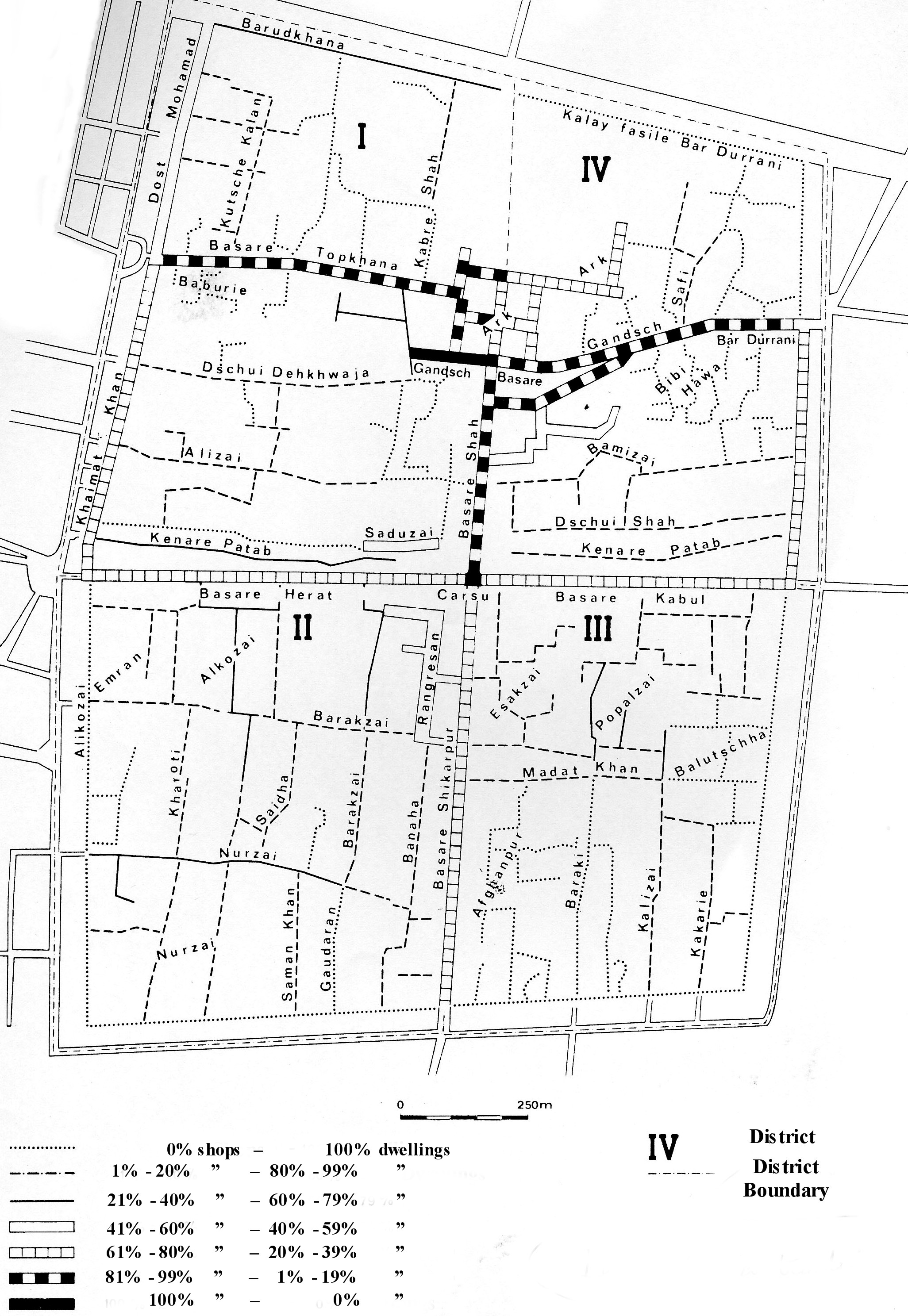
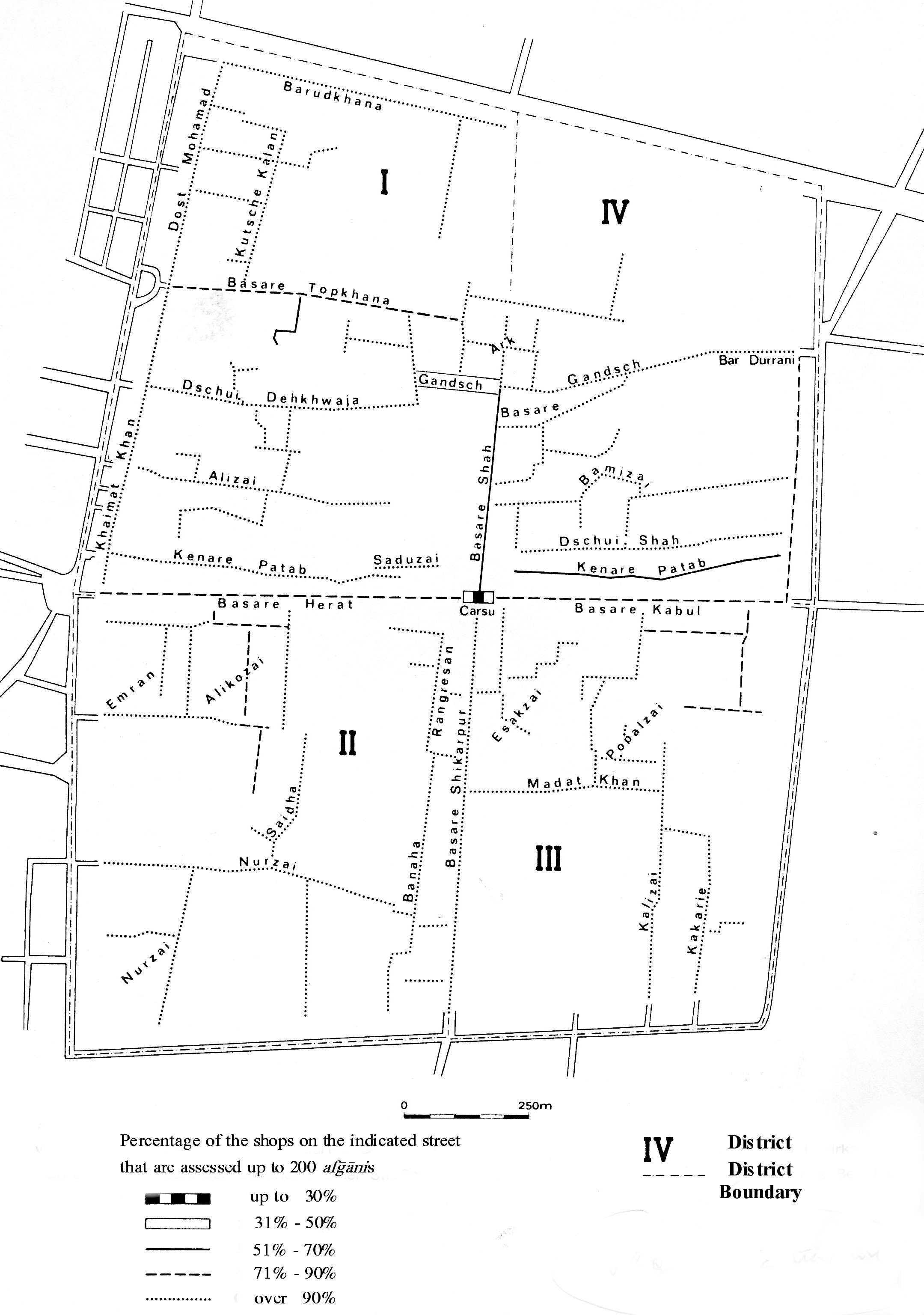
The economic activity of Kandahar was the object of an exemplary analysis (Wiebe, 1976 and 1978) that is unequalled for other Afghan towns. On the eve of the communist revolution of 1978, the main activities were still concentrated in the Old City, which accommodated the great majority of trade and craft industries, as well as most of the population. More than two-thirds (approximately 3,600 of the total of about 5,600) of the city shops and workshops were located there. Trade and artisan activities had gradually invaded the major part of the city’s main streets, starting from the initial central nucleus of the čahārsuq (see Figure 3), and proceeding particularly north (Figure 4), toward the area of the royal palace (arg), where most of the administrative buildings had been established. Work and life activities were inextricably mixed, with most of the shopkeepers and artisans living behind their stores or workshops. Only a few buildings of the čahārsuq did not contain residences.
These arrangements tended to preserve very traditional ways in Kandahar. There was no distinct evolution toward development of new city quarters that engaged in modern business practices or pursued trade in quality imports from the West, while within easy reach of residential neighborhoods (a separation commonly found in cities of the Near and Middle East). On the whole, the principle of hierarchical organization of activities remained faithful to the old pattern of Muslim cities, with a decrease in the value of products and services as one proceeds to the periphery from the center (čahārsuq), where the trade of highly valuable merchandise was concentrated. Craft industries were largely pushed to the periphery (Toepfer, p. 21). The fact that the new city quarters were separated into two distinct areas to the east and west of the Old City was certainly responsible for this situation, which is in contrast to the simple bilateral asymmetry that took shape in most Muslim cities. But the archaic nature of the economy also had been a determining factor.
In any case, it was mainly around the old center of čahārsuq that the most important and profitable activities took place, including many modern-type services. It was the place where the very rare multi-storey buildings first appeared, as well as where the taxes were the highest, such as in the busy shopping areas leading towards the arg (Figure 5). In the Old City, professional separation by crafts was still very noticeable, especially with regard to the trade in fabrics, silversmithing or goldsmithing, and also the iron, lead, and wood (carpentry) industries. The “Kabul Bazaar” located to the east of the čahārsuq was the center for selling gold and silver objects, as well as carpets. The “Herat Bazaar,” to the west of the central traffic circle, was more differentiated. The “Šekārpur Bazaar,” on the grand avenue leading to the southern gate, was more specialized in foodstuffs.
Outside the walls, there developed bazaars and streets with stores and workshops along the roads to Herat and Kabul and in the northeast, on the avenue to Manzel-e Bāḡ. Such development was encountered much less in the south, where shops remained localized within the immediate vicinity of the gates; they subsequently gave place to tile-making and pottery workshops, which used the raw, clayey material of the area’s mobile, alluvial soils. Different sectors of the city presented very diverse aspects. In the east, toward the Kabul road, there appeared garages and car-repair shops, as well as many teahouses near the bus stops. Also a number of market houses (sarāy) were built there, which held merchandise, offices, and also businesses that dealt in long-distance trading, especially the wholesale wood trade.
In the west, toward Šahr-e Now, modern hotels, restaurants, cinemas, and banks, as well as antique shops for the foreigners who frequented them, mixed with diverse neighborhood businesses, giving this sector the aspect of a true, modern commercial quarter which had been missing in the city (see above). To the south, between the gate and the tile-making quarter, trade and craftwork were oriented particularly to the needs of the rural clientele of the oasis.
Within this general picture of activities, modern industry occupied a very small part, and Kandahar remains essentially a “pre-industrial” city. The first enterprise was a woolens factory for the uniforms of the Afghan army, developed in 1933 in the northeast of the city and renovated in 1958-59 with Polish aid. It employed up to 900 workers in the 1960s, but only 220 in 1972, and appeared obsolete. It was revived and modernized in 1973. For a long time it served as the only manufacturing enterprise of any importance. Other facilities functioned on a temporary and seasonal basis, processing the agricultural products of the oasis—preserving fruit, making jams and fruit juices, and drying raisins.
In 1979, a new woolen fabrics factory was launched, with the help of German capital. Construction of a cotton fabrics factory started in 1977, 15 km east of the city. This was ready to start in 1984, but its activity was paralyzed by political and military events.
On the whole, Kandahar remained, above all, an important center of regional land ownership, the capital of the southern Pashtun lands, and the principal commercial and management seat for all southern Afghanistan. In this role it was unchallenged in the region between Kabul and Herat, both located about 500 km away. This very traditional city played a major role in the resistance against the communist revolution and the occupation by the Soviets, whose forces were never really able to secure the city and mainly were stationed at the airport, which had been built in the 1960s with American aid; it lies 16 km to the southeast of the city.
For the recent history of the city, see vii, below.
Bibliography
Vasudeva Saran Agrawala, “Place-Names in the Inscriptions of Darius,” Journal of the United Provinces Historical Society (Lucknow) 13/1, 1940, pp. 8-19.
Jamal-ud-Din Ahmad and Muhammad Abdul Aziz, Afghanistan. A Brief Survey, London, 1936. Mohammed Ali, Guide to Afghanistan, Kabul, 1938.
T. J. Arne, “A Plan of Qandahar,” Imago Mundi 4, 1947, p. 73.
H. W. Bellew, From the Indus to the Tigris, London, 1874.
Idem, The Races of Afghanistan, Calcutta and London, 1880.
C. E. Bosworth, “Ḳandahār,” in EI2 IV, pp. 535-38. Olaf Kirkpatrick Caroe, The Pathans 550 B.C.–A.D. 1957, London, 1958.
Mountstuart Elphinstone, An Account of the Kingdom of Caubul and its Dependencies in Persia, Tartary and India, London, 1815.
Joseph Philippe Ferrier, History of the Afghans, tr. Capt. William Jesse, London, 1858.
Idem, Voyages en Perse, dans l’Afghanistan, le Béloutchestan et le Turkestan, 2 vols., Paris, 1860.
Klaus Fischer, “Zur Lage von Kandahar an Landverbindungen zwischen Iran und Indien,” Bonner Jahrbücher des Rheinischen Landesmuseums in Bonn 167, 1967, pp. 129-232.
George Forster, A Journey from Bengal to England . . . , 2 vols., London, 1798.
Gazetteer of Afghanistan V: Kandahar and South-Central Afghanistan, Graz, 1980. Erwin Grötzbach, Städte und Basare in Afghanistan. Eine stadtgeographische Untersuchung, Wiesbaden, 1979.
Idem, Afghanistan. Eine geographische Landeskunde, Darmstadt, 1990.
Richard T. Hallock, Persepolis Fortification Tablets, Chicago, 1969.
Ernst Herzfeld, Archaeological History of Iran, London, 1935.
Moḥammad Maʿṣum Hōtak, Aḥmadšāhi Kandahār, 2 vols., Kandahar, 2005.
Johannes Humlum, La géographie de l’Afghanistan; étude d’un pays aride, Copenhagen, 1959.
Isidore of Charax, Stathmoi parthikoi, ed. and tr. Wilfred Schoff as Parthian Stations by Isidore of Charax. An Account of the Overland Trade Route Between the Levant and India in the First Century B.C., Philadelphia, 1914.
Scott Levi, “India, Russia And The Eighteenth-Century Transformation Of The Central Asian Caravan Trade Scott Levi,” Journal of the Economic and Social History of the Orient 42/4, 1999, pp. 519-48.
Harry Burnett Lumsden, The Mission to Kandahar, with appendices, Calcutta, 1860.
Charles Metcalfe MacGregor, Central Asia II. A Contribution Toward the Better Knowledge of the Topography, Ethnology, Resources, and History of Afghanistan, Calcutta, 1871.
J. Marquart and J. M. de Groot, “Das Reich Zābul und der Gott Zūn vom 6.-9.
Jahrhundert,” in Festschrift Eduard Sachau, ed. G. Weil, Berlin, 1915, pp. 248-92.
Charles Masson, Narrative of Various Journeys in Balochistan, Afghanistan and the Panjab, Including a Residence in those Countries from 1826 to 1838, 3 vols., London, 1842; repr. Graz, 1975.
(FNU) Masuch, “Nomadenzeltlager als Vorbild für afghanische Städtegründungen,” Technisches Gemeindeblatt 36, 1933, pp. 271-72.
Manfred Mayrhofer, Kurzgefasstes etymologisches Wörterbuch des Altindischen I, Heidelberg, 1956.
Daniel Schlumberger, L. Robert, A. Dupont-Sommer, and E. Benveniste, “Une bilingue gréco-araméenne d’Aśoka,” JA 246, 1958, pp. 1-48.
Ganda Singh, Ahmad Shah Durrani; Father of Modern Afghanistan, London, 1959.
Niels Steensgaard, “The Route through Quandahar: the Significance of the Overland Trade from India to the West in the Seventeenth Century,” in Merchants, Companies, and Trade: Europe and Asia in the Early Modern Era, ed. Sushil Chaudhury and Michel Morineau, Cambridge, 1999, pp. 55-73.
Jean-Baptiste Tavernier, Les six voyages de Jean Baptiste Tavernier . . . Première partie, 2 vols., Utrecht, 1712.
Helmuth Toepfer, “The Bazar Centres of the Capitals of Three Afghan Provinces,” Geographical Review of Afghanistan 10/1-2, 1971, pp. 17-23.
Victor Tscherikower, Die hellenistischen Städtegründungen von Alexander dem Grossen bis auf die Römerzeit, Leipzig, 1927.
Dietrich Wiebe, “Zum Problem stadtplanerischer Entscheidungsprozesse in Afghanistan,” Afghanistan Journal 2, 1975, pp. 135-47.
Idem, “Die räumliche Gestalt der Altstadt von Kandahar. Ein kulturgeographischer Beitrag zum Problem der partiellen Modernisierung,” Afghanistan Journal 3, 1976, pp. 132-46.
Idem, Stadtstruktur und kulturgeographischer Wandel in Kandahar und Südafghanistan, Kieler Geographische Schriften 48, Kiel, 1978.
Charles Edward Yate, Khurasan and Sistan, London, 1900.