


ISFAHAN
This entry will be divided into two sections:
(1) Geography of the province.
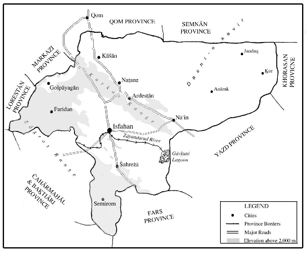
Isfahan Province is situated in central Persia between the massive central Zagros mountain range and the grand desert (see DESERT). It covers an area of approximately 107,000 km2 between 30°42′ and 34°30′ N latitude and 49°36′ and 55°32′ E longitude (Sāzmān-e barnāma, p. 1). It is bounded in the north by the Central Province (Ostān-e markazi) and the provinces of Qom and Semnān, in the south by the provinces of Fārs and Kohgiluya o Boir Aḥmadi (qq.v.), in the east by Khorasan Province, in the southeast by Yazd Province, and in the west by the provinces of Luristan (Lorestān) and Čahār Mahāl o Baḵtiāri (q.v.).
According to the 1996 national census, the population of Isfahan Province (ostān) was 3.9 million (compared to 1.5 million in 1956), comprised of 17 sub-provinces (šahrestāns), 60 towns in 37 districts (baḵšes), and 2,470 rural settlements in 116 sub-districts (dehestāns). Up to and including the 1966 census, the province of Yazd was counted within the boundaries of Isfahan Province, and from the 1986 census, the sub-province of Kāšān was annexed to Isfahan Province (see ii/2, below).
Isfahan Province consists of mountains and plains, with an average elevation of 1,600 m (see Figure 1). The central Zagros mountain range forms the western borders of the province, including the following major mountains: Dālānkuh (with a peak of 3,915 m), which extends from Faridan (q.v.) to Najafābād, Darrabid mountain (with a peak of 3,631 m) in Faridan, and Šāhānkuh (with a peak of 4,040 m) near Fereydunšahr, which runs in a southeasterly direction to Semirom and reaches the summit of Denā mountain in the province of Kohgiluya o Boir Aḥmadi. The Karkas mountains (with a peak of 3,895 m), an extension of the Central mountain range (selsela-ye kuhhā-ye markazi), extend from west of Kāšān southeastward to Nāʾin (Jaʿfari, 1989, pp. 427-29, 244-45, 353). The Karkas range divides the province into two distinct topographic and climatic areas: the more temperate western regions and the arid eastern regions.
The province consists of 52 hydrological units belonging to 9 basins and 27 sub-basins. Rivers are small and temporary, with the exception of the Zāyandarud, which totals 405 km in length, with an average slope of 0.3 percent, average annual discharge of 1,053 mcm, average annual precipitation of 450 mm, and a basin area of 27,100 km2 (Jaʿfari, 1997, pp. 247-49).
Isfahan Province can be divided into three topographic and climatic regions based on their distance from the Zagros mountains in the west and the great desert in the east: (1) Semi-humid and cold areas encompassing western and southern valleys, including the sub-provinces of Golpāyagān, Ḵᵛānsār, Faridan, Fereydunšahr, and Semirom. (2) The arid areas along the edge of the central desert, including Nāʾin, Ardestān, and Kāšān, as well as the area of desert climate in the easternmost villages of Anārak, Ḵur, and Jandaq. (3) The semi-arid region of the oasis of Isfahan—with the Zāyandarud as a main water resource—marked by a moderate climate and four distinct seasons, including the sub-provinces of Tirān and Karvan, Najafābād, Lenjān, Mobāraka, Falāvarjān, Ḵomeynišahr (formerly Mārbin), and Isfahan, as well as Šahreżā along the road to Fārs and Borḵᵛār o Meyma on the road to Qom and Tehran (for a detailed discussion, see 2, below). The average annual rainfall in the meteorological stations varies from 6.7 cm in the easternmost villages of Ḵur and Biābānak to 147 cm in the Kuhrang station; relative humidity varies between 25 and 62 percent (Wezārat-e jehād-e kešāvarzi, p. 7).
The province is generally poor in flora and fauna. The most typical of the plants are bushes and shrubs spreading over the steppes, but the landscape becomes richer with the increase in elevation. Characteristic trees are pine, cypress, plane tree, black poplar (kabuda), elm, and ash (Šafaqi, pp. 128-35). Many of the highland forests are already extinct, as the trees have been burned for charcoal (see FORESTS). The western and southern highlands offer fine pastures. The fauna of the province used to be noticeably richer than it is today, with the existence of bears, leopards, boars, and onager (see Ṭaḥwildār, p. 62). Today, there are still some ibex, wild goats, and deer in protected zones (national parks), while the marshlands around the Gāvḵuni lagoon attract hunters of wild birds. Other wild animals such as foxes, jackals (qq.v.), wolves, and rabbits are still encountered in the plains.
The population growth in the province has been sustained by water diverted from the Kārun river to the Zāyandarud, the only major river of the province. During the last few decades, employment in agriculture has been increasingly replaced by industries and services. The industrial infrastructure of the province has expanded substantially, not only by the presence of heavy industries but also with the introduction of electricity and natural gas to most parts of the province; this has made it possible to establish industries in the undeveloped regions of the province, where industrial activities are encouraged by the government (see xiv, below).
Bibliography
ʿAbbās Jaʿfari, Gitāšenāsi-e Irān I, Kuhha wa kuh-nāma-ye Irān, Tehran, 1989.
Idem, Gitāšenāsi-e Irān II, Rudhā wa rud-nāma-ye Irān, Tehran, 1997.
Masʿud Keyhān, Joḡrāfiā-ye mofaṣṣal-e Irān, 3 vols., Tehran, 1931-32.
Sirus Šafaqi, Joḡrāfiā-ye Eṣfahān, Isfahan, 1974.
Mirzā Ḥosayn Khan Ṭaḥwildār, Joḡrāfiā-ye Eṣfahān, ed. M. Sotuda, Tehran, 1963.
ʿAli Aṣḡar Ṭalā Mināʾi, Taḥlili az vižagihā-ye manṭaqaʾi dar Irān, Tehran, 1974.
Fereydun Mobaššeri and Raḥim Etteḥād, Ważʿ-e mawjud wa emkānāt-e tawsaʿa-ye manābeʿ-e āb, Tehran, 1972.
Sirus Šafaqi, Joḡrāfiā-ye Eṣfahān, Isfahan, 1974.
Sāzmān-e barnāma wa budja-ye Ostān-e Eṣfahān, Gozāres-e eqteṣādi-ejtemāʿi-e Ostān-e Eṣfahān, 1995.
Wezārat-e āmuzeš o parvareš, Joḡrāfī-ye kāmel-e Irān, Tehran, 1987.
Wezārat-e jehād-e kešā-varzi, Comprehensive Studies for Agricultural Development, Provincial Synthesis (Isfahan) XIX, Mohandesin-e mosāver-e Jāmeʿ-e Irān, Tehran, 2001.
In central Iran, a major urban alignment punctuates the northeastern foothills of the Zagros. An entire series of large villages and towns are spread out there, between the mountains and the central desert. The region benefits both from substantial water resources and from its strategic location at the intersection of these two largest natural areas of the country.
Isfahan city (32°39′35″N, 51°40′17″E), although in a semi-arid environment (with 147 mm average annual precipitation, at 1,590 m elevation), lies at the outlet of a major river, the Zāyandarud. The river drains a large area well-watered by rain in the western Zagros, and its water nourishes a huge foothill oasis that has always provided the basis for a significant urban concentration.
By contrast, the oases furthest southeast of the foothills, such as Yazd and Kerman, are isolated; separated from the northern mountain ranges and Khorasan by harsh deserts, they only have access, through the southern mountains, to remote areas already affected by aridity and thus very poor. In the absence of any major river flowing from these mountains, the water resources of the remote areas are supplied only by underground aquifers (see ĀBYĀRI), whose use requires complicated and expensive works.
The exceptional location of the Isfahan oasis should be the point of departure for explaining the existence of a city that is one of the largest “desert cities” in the world. The volume of water available from the Zāyandarud was substantially increased by the completion in 1954 of the 2,700-meter Kuhrang tunnel—a project dating back to Shah Ṭahmāsp I (r. 1524-76) to transfer into the river the waters of the upper Kārun. The latter flows close to the Zāyandarud and 60 m above it, at 2,300 m elevation, before heading towards the Persian Gulf. The construction of the tunnel raised the average annual flow of the Zāyandarud from 772 to 960 million cubic meters. Nine years out of ten, the average annual flow exceeds 910 million cubic meters, and one year in 10, 1,680 million cubic meters. However, the runoff is very unequally distributed during the year. On the basis of natural rate of flow, the seasonal coefficients are 45 percent for spring, 27 percent for winter, 17 percent for the fall and only 11 percent for the summer—the period when the need is greatest.
It has therefore always been necessary to call upon additional resources. The qanāts have remained few: fewer than a dozen north of the oasis (districts of Lenjān and Mārbin, where they have partly dried up since the digging of deep wells) and some others downstream (Barān district). Wells, however, have increased during the 20th century: deep (60 to 100 m) in the north, where salinity is high (generally above one gram per liter), less deep (8 to 10 m) around Isfahan. As early as the late 1960s, about 800 pump wells were noted with a capacity of 8 to 25 hp, reflecting the progress of a medium-sized urban landownership with market-oriented production (Cordonnier). Further downstream, in Rudašt, village wells 4 to 5 m deep, drawn by animals, have always existed. During the summer period when river water was conserved for upstream areas, these downstream areas tapped the underflow beneath the river bed. The fairly regular flow in the old branches of the river also was used. In the 1960s, the total withdrawal from underground waters amounted to about 10 cubic meters per second in the summer, that is, more than half the minimum flow of the river.
The diversion of the Kārun, whose mountain regime sustains a higher flow during the summer than the Zāyandarud, has only slightly improved the seasonal situation, bringing the summer coefficient to no more than 20 percent, with that of spring 44 percent, winter 21 percent, and fall 15 percent. The cumulative water resources, nonetheless, remained far too low to enable an optimal exploitation of the whole cultivable area: in 1967 only 43,000 hectares were effectively cultivated (3,000 of which bore a double harvest) out of an irrigable area estimated at 78,000 hectares. The oasis formerly led a frugal life with strict control of water during most of the year (see Fesharaki, 1967; Planhol, 1969).
Distribution of these resources has remained based, up to the present, on rules codified in 1545 by Shah Ṭahmāsp (Lambton, 1937-39). The water supply, unregulated from 22 November to 5 June, is subject to control from 6 June to 21 November, that is, 165 days per year. It is entirely saved for upstream districts from 22 June to 31 October; the three downstream districts (Kerāraj, Barān, Rudašt) thus enjoy a total of only 37 days of supply, versus 75 for upstream districts and 53 for central districts (Jey, Mārbin, and Barzerud, on the outskirts of the city). As frequently occurs in the sharing of running waters in arid regions, downstream districts have only limited access to water, with practically no possibility for summer cultivation—hence the main regional differences within the oasis.
These internal contrasts are indicated, above all, in the population distribution. In 1970, population was estimated at 200,000 to 250,000 inhabitants for the irrigable area (excluding the town of Isfahan). From a total of approximately 500 villages, three-quarters were located upstream, where they were larger (500 to 5,000 inhabitants), whereas, downstream, small villages predominated (often fewer than 100 inhabitants). The density thus diminished quite strikingly from 300 to 500 inhabitants per km2 of irrigable area in the upper districts to 50 to 250 per km2 downstream. One obvious consequence of such a difference is that the highly populated upstream villages own generally less irrigable land, often less than 100 hectares per village, while this figure increases considerably downstream, with agriculture becoming significantly less intensive.
Thus in the upper reaches of the oasis, cultivation remains cereal-oriented. Predominantly, wheat-rice crop rotation is practiced, in winter and summer respectively; vegetables, fodder, and sugar beets may complement the wheat. Half of the lands remain fallow each year. The agrarian structure is often organized in a number of extensive fields (ṣaḥrā)—up to 6 per village. Work migration to Khuzestan or Tehran attests to the density of the population and even over-population.
In the center, around Isfahan, in the districts of Jey, Mārbin, and Barzerud, the organization is entirely different. It is the sector par excellence for market gardening, raising fruit, onions, fresh vegetables, melons, water-melons, and sugar beets for the sugar refinery in the city. Orchards producing fresh fruit predominate in the center and give way to almond trees on the periphery. Lands are usually enclosed, and farming is often by the hoe. Villagers keep milk cows. As fertilizer, cattle manure is supplemented with that of pigeons, which are sheltered in pigeon towers that for centuries (at least since the Mongol period) have been an essential feature of the countryside (Beazley). Overpopulation and work migration remain significant, mainly downstream of the oasis.
Downstream, cereal crops and the practice of crop rotation predominate again, but the shortage of water leads to a different pattern compared with upstream: the norm is winter wheat alternating with fallow land, up to 70 percent of the soil remaining fallow every year; summer crops (especially melons and watermelons) are limited to the immediate vicinity of the villages. Sheep and goat rearing become proportionally more significant than cattle. These regional contrasts were very noticeable until 1970, when the large Shah ʿAbbās dam was implemented upstream of the oasis. The dam, with a reservoir 1.25 km3 in extent, generates hydro-electric power, provides water for domestic use in the city, and regulates distribution of water for agriculture during the summer. No detailed analysis, such as that conducted in 1967 (Fesharaki; Planhol), has been made more recently, but it would appear that irrigation has developed in the downstream sectors and that agricultural production has diversified there. At the same time, the drilling of deep wells in the peripheral areas has continued vigorously, creating islets of intensive cultivation.
Already in the late 19th century, the Isfahan oasis exported cereals to neighboring regions in central Iran (e.g., Yazd and Kāšān; Costello, p. 110); and in the 1960s there was a high volume of fruit and vegetable exports to Tehran. Commercialization of agricultural production in the Isfahan oasis has only increased, and Isfahan has become a highly specialized agricultural region integrated into the world economy and exporting to markets around the Persian Gulf.
Agricultural lands have mostly been owned by residents of the city and cultivated by traditional indirect exploitation (approximately 70 percent under sharecropping tenancy in irrigated areas). Agrarian ownership, however, was of small to medium size, combined with a considerable proportion of waqf (religious endowment) properties. It is noteworthy that the first phase of the agrarian reform did not have to be implemented here, since nowhere did ownership extend to an entire village. The city has always dominated the oasis, but quite differently from the manner in other large cities in central Iran (Yazd and especially Kermān), where huge agrarian ownership always prevailed. Direct cultivation by city dwellers around deep wells also increased in the last quarter-century.