


HAMADĀN
iv. HAMADĀN URBAN PLAN
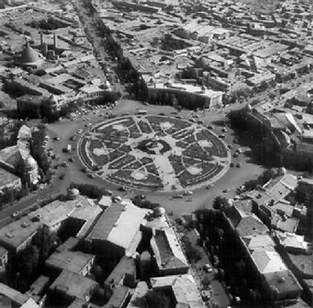
Hamadān is the only city in Persia which has a star-shaped urban design, with six boulevards and a network of avenues autonomously branching out in various directions from the circular city center. This is not unlike the old cities of Firuzābād and Baghdad (qq.v.), although the autonomous branching of the avenues and smaller alleys in Hamadān does not conform to any pattern (see PLATE I ).
In 1928, German architects were given the task of designing a plan for the city which would modernize its urban infrastructure and be suitable for motor traffic. The resultant project was eventually implemented in 1933. Six 30-meter wide boulevards converged at an angle of 60 degrees on the central city circus (named, at first, after Moḥammad-Reżā Shah, and, later, after Khomeini). This meydān was 120 meters in diameter (Mohandesin-e mošāwer-e Marjān, p. 20).
According to the census of 1996, Hamadān covered an area of 53.5 sq. km, having grown steadily in the past forty years, from 350 hectares in 1956 to 575 hectares in 1966 and 1,288 hectares in 1976 (Mohandesin-e mošāwer-e Mojdā, p. 103). The expansion of Hamadān after the 1979 Revolution has exceeded all urban development forecasts. While an expansion to 4,064 hectares by 2003 had been predicted for the city, by 1996, seven years before that date, its total area had already reached 5,350 hectares.
The old quarters of Hamadān have narrow alleys and passageways which are usually covered, and therefore dark. The houses here are compact and lead directly to each other; the rooms, which are usually arched-shaped, represent a certain style of life that is almost extinct today. Hamadān’s buildings fall into three categories: inhabitable, repairable and in need of demolition; the majority belong to the third category. In the mid-1960s, 8% of the buildings were inhabitable, 15% repairable and 77% in need of demolition. Population density in Hamadān varies considerably according to precise location; it declines rapidly from more than 200 persons in the old quarters, which are located centrally, to less than 100 in the suburbs at the periphery (Mohandesin-e mošāwer-e Marjān, p. 20). There are three main centers of commercial activity in the city: the main bazaar, which is the hub of business, the secondary bazaars and market places (meydāns) and scattered commercial buildings.
Hamadān’s future expansion is expected to stretch towards the south, the southeast and the southwest, that is, at the foot at the Hagmatāna hills.
Bibliography
Mohandesin-e mošāwer-e Marjān, Ṭarḥ-e jāmeʿ-e Hamadān, summarized by ʿAbd-al-Ḥamid Ešrāq, Tehran, 1968.
Mohandesin-e mošāwer-e Mojdā, Ṭarḥ-e tawseʿa wa ʿomrān-e Hamadān, Hama-dān, 1984.
Sāzmān-e barnāma wa budja-ye Hama-dān, Āmār-nāma-ye ostān-e Hamadān, 1377, Hamadān, 1998.