


DĀMḠĀN, Persian town located on a plain south of the Alborz range, 342 km east of Tehran (54° 20’, 36° 10’ N, 1115-30 m above sea level). It was for a long time the capital city of the small province of Kūmeš (Ar. Qūmes, Gk. Kōmisēnḗ; Lat. Comisene; see, e.g., Strabo 11.9.1), now Ostān-e Semnān (for the geomorphological and ecological setting of the Dāmḡān plain, see O. G. Meder in Dyson and Howard, pp. 7-12). The town was reputed to have been founded by Hōšang, the second of the mythical Pīšdādīān kings of Iran (Mojmal, ed. Bahār, p. 39; Nozhat al-qolūb, ed. Le Strange, I, p. 161). There is apparently no satisfactory explanation of the name or its origin, though it has been suggested that Dāmḡān may be a contraction of deh-e moḡān (village of the magi; Ḥakīm, p. 591; Yaḡmāʾī, p. 5; on Zoroastrians living in Dāmḡān, see below).
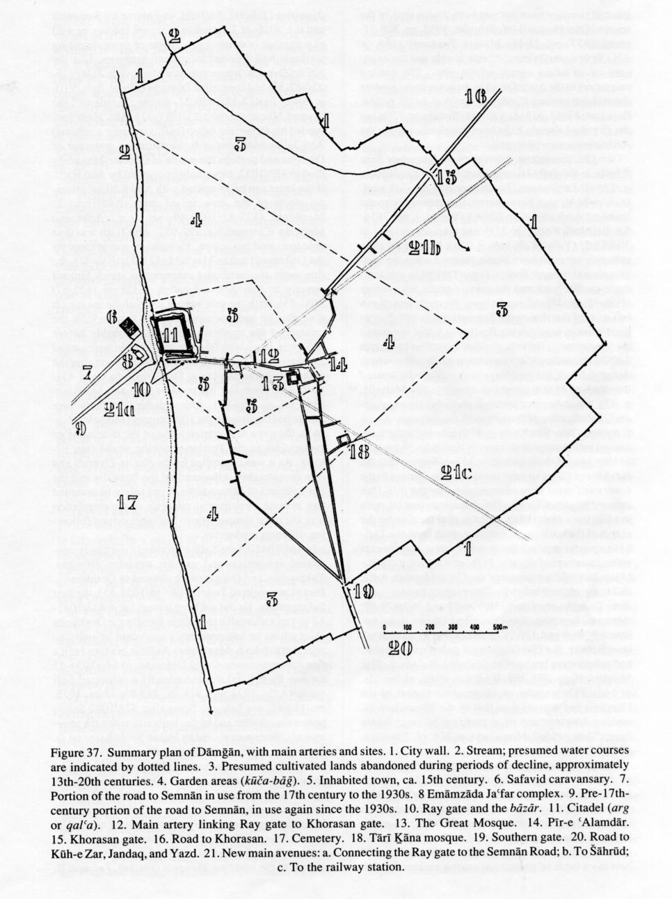
Dāmḡān, which is situated on the main highway from Tehran to Nīšāpūr, Mašhad, and Herat, also dominates less important roads north to Sārī and Gorgān, as well as tracks leading south to Yazd and Isfahan via Jandaq (Le Strange, Lands, map V; Adle, 1971, pp. 74-85). From the quasi-triangular plan of its high defensive wall (Figure 37; Schmidt, 1937, figs. 4-5; Adle, 1971, p. 93 figs. 4-5) it can be seen how the streams fanning out to the southeast from Ābbaḵšān (cf. Adle, 1971, p. 73; idem, 1970, I, pp. 27-29 fig. 7; Dāmḡānī, pp. 14-15) determined its layout; the wall was constructed, probably in the late Sasanian period (Balāḏorī, Fotūḥ, p. 318, referring to the Muslim assault on the city gates), along canals and irrigated gardens. The present wall was built in 309/921-22, in order to ward off ʿAlid attacks (Ebn al-Aṯīr, VIII, p. 124). In the 19th century the town had five gates, but originally the wall was pierced by only three gates, one in each of its three sides: the Ray gate (west), the Khorasan gate (east), and a southern gate of unknown name (Figure 37 nos. 10, 15, 19). Abū Dolaf, who visited Dāmḡān in the mid-10th century, expressed admiration for it (fol. 193b), but Maqdesī (ca. 375/985; Moqaddasī, pp. 355-56), who was there shortly afterward, does not seem to have shared his admiration, describing it as a small town with unattractive baths and ugly bāzārs (cf. Adle, 1971, pp. 91-100). The names of the quarters (maḥallāt) at that period are unknown, but in 1300/1883 they were mentioned by Eʿtemād-al-Salṭana in his thorough description of the town (III, pp. 266-302; Adle, 1971, p. 101). The rapid modern expansion of the built-up areas has been concentrated on the northern and northwestern side, toward Semnān and Tehran (Banāhā, maps 36-38).
The windy climate of Dāmḡān was noted by Abū Dolaf (fol. 193b; cf. Yāqūt, Boldān II, p. 539). From at least as early as the 12th century it was believed that the wind blowing from the valley of the Čašma ʿAlī, 25 km northwest of Dāmḡān and the mountains surrounding it, was caused by impure matter thrown into a mineral spring called Bād-ḵānī, 27 km northeast of Dāmḡān (Adle, 1970, I, pp. 42-44, fig. 14). Thanks to Moḥammad Ṭūsī (pp. 113-14) and Zakarīyāʾ Qazvīnī (p. 180), it is possible to identify this spring, with its yellow-ocher waters, with the one mentioned by Abū Dolaf (fol. 143v) and other authors, who referred to a spring carrying blood capable of transforming quicksilver into stone. Aside from this northern wind, there are seven other winds that also blow irregularly in Dāmḡān (Ṭāherīyā, 1347 Š./1968, pp. 22-23; Banāhā, pp. 131-32; see climate). January is the coldest month, with an average temperature of -5.8° C, and August the hottest, with an average temperature of 34.4° C, but extreme temperatures range from -15° C to 41° C. Precipitation in the region is irregular, the yearly average being 87 mm (O. G. Meder in Dyson and Howard, pp. 7-8; for the latest figures, see Banāhā, pp. 133-34).
History. In prehistoric times a settlement, known today as Tepe Hissar (Tappa Ḥeṣār; ca. 4590-1705 b.c.e.; Dyson and Howard, p. 143), was established southeast of the present town of Dāmḡān on raised ground next to an old bed of the Dāmḡānrūd, a permanent stream flowing from Čašma ʿAlī (Dyson; idem and Howard; Schmidt, 1931; idem, 1937). From the modern headwork north of the town there is a fan of canals extending south to within 500 m of the Tehran-Mašhad road; the surface of this area is heavily scattered with a mixture of late Iron Age, Parthian, and Sasanian potsherds. In the Parthian period, after a hiatus of 1,500 years, Dāmḡān again became a major settlement in the province of Kūmeš and remained so through the Sasanian period as well (Maurer Trinkaus, 1981b, figs. 3, 4; idem, 1985, pp. 130, 132, figs. 2-3). Although Dāmḡān was long identified in Western literature with the ancient city of Hecatompylos (Šahr-e Kūmeš), recent excavations have proved that identification incorrect (see Hansman; idem and Stronach). The province of Kūmeš was the location of one of the renowned sacred fires of Sasanian Persia (ātaxš ī axwarišnīh “fire without nutriment”; Bundahišn 18.24; cf. Masʿūdī, Morūj, ed. Pellat, II, p. 398; Šahrestānī, II, p. 59). The remains of a Sasanian palace just southeast of the present town and next to Tepe Hissar (Schmidt, 1933, pls. 76, 78-79; idem, 1937, pp. 327-50) attest the importance of Dāmḡān in the late Sasanian period; they may be dated to the end of the 6th century, when Prince Besṭām revolted against Ḵosrow II Parvēz (590-628), his nephew, and established an ephemeral independent kingdom (ca. 592-96 or 600; see besṭām o bendōy). Perhaps it was at that time that the seat of government was transferred from Šahr-e Kūmeš to Dāmḡān (Hansman, 1968, p. 138; cf. Markwart, Provincial Capitals, pp. 55-58). The palace seems to have remained in use in the 7th century under Omayyad rule (41-132/661-750; Thompson, p. 7). Although pre-Islamic remains have not yet been discovered in the town of Dāmḡān itself (cf. Schmidt, 1933, pp. 329-31; idem, 1937, pp. 11-16; Maurer Trinkaus, 1985, p. 131), it is nevertheless difficult to rule out the existence of an urban center on the site. The earliest references to the name Dāmḡān do not seem to predate the mid-9th century (Qodāma, Ketāb al-ḵarāj, p. 244; Balāḏorī, Fotūḥ, p. 318; Yaʿqūbī, Boldān, p. 276), but the city must already have been in existence when the Arab armies arrived there.
Dāmḡān, sometimes referred to as Qūmes or Šahr Qūmes in the early Islamic sources (Ebn Ḵordāḏbeh, p. 23; cf. Le Strange, Lands, pp. 364-65; Schwarz, Iran, p. 814), may have submitted temporarily to the invading Arab armies in 22/643 (Ṭabarī, I, pp. 2656-57; Balāḏorī, Fotūḥ, p. 318) and then definitively in 30/651-92 (Yaʿqūbī, Boldān, p. 276). Its primacy as an urban center must have been enhanced when the congregational mosque known as the Tārī-ḵāna was built there, probably around the middle of the 8th century (Godard, pp. 231-35; see below). Nevertheless, it can be assumed that there were Zoroastrians in Dāmḡān, as there were in neighboring Besṭām, at least until the 9th century. The city was devastated on 18 Šaʿbān 242/20 December 856 by a violent earthquake, which destroyed half the buildings and supposedly caused the death of 45,096 people (Ambraseys and Melville, p. 37), a number that, though undoubtedly exaggerated, is indicative of the extent of the damage. About sixty years later Ebn Rosta (p. 170) referred to the ruins caused by the same cataclysm in Ḥaddāda, 36 km east of Dāmḡān (cf. Moqaddasī, p. 355, affirming that the outskirts of Dāmḡān were in ruins). The damage to the town itself must have been repaired by the mid-10th century, however, for Abū Dolaf characterized Dāmḡān as a fine town (fol. 193v). Perhaps after the disaster the center of the built-up area shifted north from the Tārī-ḵāna quarter toward those where new monuments were constructed in the 11th century (e.g., Pīr-e ʿAlamdār and the minaret of the Great Mosque; Adle, 1971, fig. 4; see below). The earliest known coins from Dāmḡān are dated 336/976-77 and 369/979-80; there are, however, coins inscribed Qūmes dated between 91/709 and 170/787. According to some Arab geographers, the Dāmḡānīs were pale-faced, affable, and cooperative but warlike (Yaʿqūbī, Boldān, p. 276; Moqaddasī, pp. 355, 368; Ḥodūd al-ʿālam, ed. Sotūda, p. 146). They spoke an idiom close to that of the Gorgānīs but sharper than that of the Māzandarānīs, making frequent use of a prefixed hā (e.g., hādeh “give,” hākon “do”; Moqadassī, p. 368; cf. Ṭāherīyā, 1344 Š./1965).
Dāmḡān apparently reached its zenith in the first half of the 11th century, under the governorship of Abū Ḥarb b. Moḥammad Baḵtīār, a Ziyarid general and patron of the poet Manūčehrī, who celebrated him in his panegyrics (Adle, 1972, pp. 271-73). Its population had presumably increased to about 25,000, and it had long since escaped from direct ʿAbbasid rule and become a bone of contention among various Persian dynasties (Taherid, Saffarid, and above all Samanid) and the ʿAlids of Ṭabarestān (see below), as well as a number of condottieri. Some of these disputing warlords had founded important dynasties, like the Shiʿite Ziyarids, whose ancestor Mardāvij b. Zīār (315-23/927-35) had controlled Dāmḡān (Ebn al-Aṯīr, VIII, p. 304). In 417-18/1026-27, during the reign of the Ziyarid Manūčehr (402-23/1012-32), Abū Ḥarb succeeded his father, the ḥājeb (in this instance a general) Abū Jaʿfar Moḥammad b. Ebrāhīm, as governor of Dāmḡān and perhaps the whole of Qūmes. Manūčehr died in 423/1032, presumably poisoned by Abū Ḥarb, if the latter can be identified with Abū Kālījār, maternal uncle of the new, infant ruler, Anūšīrvān b. Manūčehr (423-41/1032-49; see, e.g., Adle and Melikian-Chirvani, pp. 292-95). Abū Ḥarb was thus able to extend his power. He took, or was granted by the Ghaznavid sultan Masʿūd I (421-32/1030-41), the title amīr-al-omarāʾ and managed to attach himself directly to the ʿAbbasid caliph al-Qāʾem (422-67/1031-75), with the title mawlā amīr-al-moʾmenīn. It was after he had assumed this title that he built the minaret of the mosque in Semnān, probably before 425/1034, when both Dāmḡān and Semnān were sacked by marauding Ḡozz Turks (Adle, 1975). Soon after the defeat of Sultan Masʿūd at Dandānqān in 431/1040 Abū Ḥarb lost his power (Adle and Melikian-Chirvani, pp. 269-82). Although the Dāmḡānīs were said to be Hanafites in the 10th century (Moqaddasī, p. 365), the town also contains one of the oldest Shiʿite emāmzādas in the Persian-speaking world (see below). As it was controlled by the Shiʿite Ziyarids and was considerably influenced by the Ismaʿilis and the Shiʿite rulers of Māzandarān, it can safely be assumed that at least a substantial minority of the population was Shiʿite or sympathetic to Shiʿism, perhaps following different tendencies.
In 434/1042-43 the Saljuqs divided their newly conquered territories, and on that occasion Dāmḡān, Ṭabarestān, and Gorgān were allotted to Qutulmuš b. Esrāʾīl, a cousin of Ṭoḡrel (429-55/1038-63), the first Saljuq sultan. He did not keep it long, for in 433/1041-42 Ṭoḡrel entrusted it to Asfār b. Kordūya, a Deylamite chief whom he had previously appointed as guardian over Anūšīrvān b. Manūčehr. Asfār in his turn built a fine funerary tower, Čehel Doḵtarān, in 446/1054-55 for one Pīr-e Eṣfahān, undoubtedly a respected Sufi guide (Adle, 1972, pp. 273-76, 282-83; idem, 1975, pp. 183-86; see below). Soon after 474/1082 Saljuq power was challenged by the Ismaʿilis, when the province of Qūmes was visited by Ḥasan Ṣabbāh (see dāʿī). Through the efforts of Raʾīs Moẓaffar (Mostawfī), one of his ardent followers, in 489/1096 he was able to take possession of Gerdkūh fortress (Dež-e Gonbadān), 18 km west of Dāmḡān. That stronghold, one of the mightiest and most impregnable in Persia, ensured the Ismaʿilis’ supremacy in the entire region for nearly 180 years (Adle, 1972, pp. 283-84; Sotūda, pp. 143-64), until at least the end of 658/1260; they refused to submit to the invading Mongols (Jūzjānī, Ṭabaqāt II, p. 186). In that period Dāmḡān was caught between a variety of rival forces: the official central power (represented in turn by the Saljuqs, the Ḵᵛārazmšāhs, and the Il-khanids) and various local and Shiʿite powers (Ismaʿilis, the reinstalled Bavandids, etc.), who also fought among themselves. It was in this context and probably starting in the 12th century that the decline of Dāmḡān began; the city also suffered several episodes of famine and destruction (see, e.g., Banāhā, pp. 40-42, 45-48; Ṭāherīyā, 1347 Š./1968, pp. 72-76; Dāmḡānī, pp. 29-53).
Dāmḡān was a mint town only sporadically before the Mongol invasion, after which it minted almost continuously from about the 1230s or 1240s until the early Safavid period (S. Album, personal communication; cf. Zambaur, p. 115). With the fall of the Il-khanids and the rise of local dynasties, Dāmḡān was transformed into a center of agitation under the revolutionary Sarbadārs, who did not recognize the institution of kingship. In 759/1357-58 Pahlavān Ḥasan Dāmḡānī became sardār (i.e., commander) in their chief city, Sabzavār; in the same year he had to face an uprising led by ʿAlī Moʾayyad in Dāmḡān. ʿAlī struck Shiʿite coins in Dāmḡān, and this practice became standard in 763/1361-62, when the Sarbadārs accepted his authority and recognized Shiʿism as the official religion (Smith, pp. 77-78, 143-46; Dāmḡānī, pp. 55-61). It is clear that Shiʿism already had a firm foothold in the town, probably from at least as early as the period of Ziyarid rule (see above). At any rate the spread of Shiʿism in Dāmḡān must have been complete long before its establishment as the official religion of Persia by Shah Esmāʿīl I (907-30/1501-24) in 907/1502. In 783/1381, however, the sarbadār ʿAlī Moʾayyad had to submit in his turn to Tīmūr (771-807/1370-1405), whose reign brought ruin and misfortune to Dāmḡān. In a period of fifty-five years it experienced three massacres and destructive raids (806/1404 under Tīmūr, 852/1448 under the Timurid Mīrzā ʿAbdal-Laṭīf, and in 861/1457 under Moḥammad Mīrzā Qara Qoyunlū; Adle, 1970, pp. 89, 100-01, 116).
In 914/1508 the Timurids lost Dāmḡān, their last refuge, to the Uzbeks, who in turn had to abandon it to the Safavid Esmāʿīl I in 916/1510. The town was reoccupied in 933/1527 by the Uzbeks, but it was definitively retaken in 934/1528 by Shah Ṭahmāsb (930-84/1524-76; Adle, 1970, pp. 143-48, 154-55, 159, 173, 177-79); the town, which had suffered heavily during the preceding twenty years, remained in Safavid possession until the conquest of Isfahan by the rebellious Afghans in 1135/1722. During the Timurid and Safavid periods the population was only about 2,000-3,000, and the decline continued through the 18th century (Adle, 1971, pp. 102-04). In the anarchic situation that prevailed in that century Fatḥ-ʿAlī Khan, chief of the Ašāqabāš Qajar tribe, apparently took a position against the weak Safavid ruler Ṭahmāsb II (1135-45/1722-32). He besieged Dāmḡān, forcing the governor, Ḏu’l-Feqār Khan, to flee, but soon he changed his mind and became Ṭahmāsb’s commander-in-chief for a short time, in 1138/1726 (Lockhart, p. 280). He was eliminated by Nāder (subsequently Nāder Shah, 1148-60/1736-48), who entered Dāmḡān victoriously with the shah on 9 Rabīʿ I 1142/2 October 1729, after having defeated Ašraf Ḡilzay three days earlier in Mehmāndūst, 21 km east of Dāmḡān. Displeased with the manners of Dāmḡān’s prefect (dārūḡa), Nāder had his quarters and the neighboring part of the town destroyed by gunfire. Later he commanded that a small defensive wall be constructed within the old city wall (Ṭāherīyā, 1347 Š./1968, p. 66).
A new period of political and military upheaval in Dāmḡān began with the assassination of Nāder Shah in 1160/1747. It lasted until the conquest of the town by Āqā Moḥammad Khan Qājār, whose nephew and successor, Fatḥ-ʿAlī Shah (1212-50/1797-1834), had been born there on 18 Šawwāl 1185/24 January 1772 during the period 1182-91/1769-77, when his father, Ḥosaynqolī Khan Qājār Jahānsūz, was governor under Karīm Khan Zand (1163-93/1750-79). Ḥosaynqolī Khan rose against Karīm Khan but was driven back by Zakī Khan Zand, who massacred the Dāmḡānīs during his march toward Māzandarān against Jahānsūz (ca. 1184-90/1770-76; Perry, pp. 139-46; Mūsawī, pp. 170-75; Ṭāherīyā, 1347 Š./1968, pp. 81-83; Dāmḡānī, pp. 73-74; Adle, 1971, pl. 16A). Āqā Moḥammad Khan, having conquered Khorasan from the Afsharid prince Šāhroḵ Afšār (1210/1796), tortured him to death for having carried off Nāder Shah’s treasury. The deposed prince was buried in the ḵānaqāh at Dāmḡān, subsequently known as Qabr-e Šāhroḵ (see below; Adle, 1974, pp. 182-84). By the second half of the 19th century Dāmḡān had only about 1,500 inhabitants (Adle, 1972, pp. 102-04).
The last bloody and destructive events in Dāmḡān took place on 8 Moḥarram 1330/30 December 1911, during the Constitutional Revolution, when constitutionalists from Tehran successfully defeated supporters of Moḥammad-ʿAlī Shah (1324-27/1907-09) who had taken control of the town on their march toward the capital (Ṭāherīyā, 1347 Š./1968, pp. 84-85; Dāmḡānī, pp. 78-82). At about the beginning of the 20th century the population apparently started to climb (5,000 in 1308 Š./1929, 8,900 in 1335 Š./1956; Adle, 1971, pp. 102-03), reaching 13,175 in 1345 Š./1966 (Ṭāherīyā, 1968, p. 31) and 25,500 in 1362-63 Š./1983-84 (6,369 families; annual rate of growth 5.6 percent, with a 73.6 percent literacy rate; Markaz-e āmār, 1364 Š./1985, table 2). The last census, conducted in 1365 Š./1986, revealed that 34,057 people were then living in the town of Dāmḡān itself (Markaz-e āmār, 1368 Š./1989, p. 1). The presence, if any, of Jews or Christians in Dāmḡān has gone unnoticed in the historical sources, but in the census of 1365 Š./1986 twenty-seven people in the town and twenty-six in the villages of the surrounding district declared themselves to be Zoroastrians (Markaz-e āmār, 1368 Š./1989, p. 4). Today Dāmḡān, which is the administrative center of a šahrestān, is only the third city of the region, after Semnān and Šāhrūd.
Monuments. Dāmḡān is among the richest Persian cities in archeological remains and monuments ranging from the 5th millennium b.c.e. to the Qajar period (for the most important pre-Islamic sites, see above).
The earliest surviving Islamic monument is the Tārī-ḵāna mosque (second half of the 8th century, perhaps earlier). It was built by means of traditional Sasanian architectural techniques on an imported hypostile (sometimes called “Arab”) plan. In structure it shows remarkable affinities with the Sasanian palace at Tepe Hissar (Godard; Schmidt, 1937, pp. 12-16, 327-50). This mosque and its less impressive counterpart in Fahraj are the oldest standing mosques in Persia. The cylindrical minaret attached to the Tārī-ḵāna mosque is datable to 418-19/1027-28 by a Kufic building inscription in the name of Abū Ḥarb Baḵtīār as ḥājeb of Manūčehr; it was perhaps a replacement for an earlier minaret destroyed in the earthquake of 242/856 (for other evidence, cf. Bloom, pp. 150-52) and can be considered the earliest datable monument of its kind in Persia (Adle, 1972, pp. 242-48, 263-64, 269-70, 285-86, fig. 2, pl. 26; Bloom, pp. 152-55; Blair, pp. 96-97).
The second important surviving monument is Pīr-e ʿAlamdār (417/1026), a cylindrical tomb tower, one of the earliest of its kind, constructed by Abū Ḥarb for his father (Adle, 1972, pp. 231-35, 250-56, 270, pls. 18-20, 29 and 35; Blair, pp. 93-95). In the first years of the 14th century a small mosque, now in ruins, was added to this mausoleum. The work was carried out by the Dāmḡānī master Ḥājī b. Ḥosayn b. Abī Ṭāleb, who also worked on the architectural complex of Bāyazīd at Besṭām (Sarre, pp. 113-14, pl. 84, figs. 154-55; Wilber, pp. 149-50).
Of the pre-Saljuq Great Mosque at Dāmḡān nothing seems to remain. From the mid-11th century, however, there survives a fine cylindrical minaret with a Kufic inscription in blue-glazed tiles at the top. The inscription, which has not yet been deciphered, is the oldest specimen of glazed tiles in situ in Persian architecture (Adle, 1972, pp. 248-49, 264-68, 284-85, fig. 3, pls. 27, 36; idem, 1983, illustrations facing p. 300; idem, 1984, pp. 290-92, figs. 7-8; Bloom, p. 160; Blair, pp. 191-93).
The architectural complex of Emāmzāda Jaʿfar (q.v.) is built around the tomb of Jaʿfar b. ʿAlī, a descendant of Ḥosayn b. ʿAlī, the third Shiʿite imam, and a brother of Oṭrūš (Nāṣer Kabīr), who restored the Zaydī kingdom in Ṭabarestān. Jaʿfar was killed around 287-89/900-01, when his brother, having been defeated by the pro-Samanid general Moḥammad b. Hārūn, took refuge in Dāmḡān (Adle, 1984, pp. 294-97 figs. 9-10; Blair, pp. 123-25). The complex that developed there became renowned as both a place of pilgrimage and a center (ḵānaqāh) for Sufi mystics. The tombstone of Jaʿfar bears perhaps the oldest existing Kufic inscription in Persia, datable shortly after his death. Later, in the 11th century, the tomb itself was decorated with a new inscription molded in plaster (Adle, 1984, pp. 292-97, figs. 9-10). The mausoleum, an almost square domed building, has often been repaired but dates mainly from the 11th century, or perhaps even earlier, as some parts are constructed of large sun-dried bricks, typical of earlier building techniques. An imposing tomb tower, the Čehel Doḵtarān, dated 446/1054-55, stands on its northern side (Adle, 1972, pp. 235-38, 256-59, 282-83, pls. 21-23, 30-32); it was probably built under the influence of the Sufi structures in neighboring Besṭām. At the southeastern corner of the complex is a small domed chamber known as Qabr-e Šāhroḵ (Šāhroḵ’s tomb), perhaps of the late Saljuq period. The room was used as an abode or a meeting place for Sufis under the Timurid Šāhroḵ (807-50/1405-47), who ordered extensive repairs. It remained in use to the reign of the Safavid shah Solṭān-Ḥosayn (1105-35/1694-1722). In 1210/1796 it became the last resting place of Šāhroḵ Afšār (see above; Adle, 1974, pp. 173-85; Hillenbrand, pp. 160-01, pl. 7a).
(For other historical buildings in Dāmḡān see Eʿtemād-al-Salṭana, III, pp. 267-81; Yaḡmāʾī, pp. 31-32, 36-60; Ḥaqīqat, pp. 321-29; Ṭāherīyā, 1347 Š./1968, pp. 100-42; Dāmḡānī, pp. 88-103, 115-39; for town planning and houses, see Banāhā, pp. 163-282.)
Agriculture. Agriculture in Dāmḡān has always depended mainly on the waters flowing from Čašma ʿAlī (Nozhat al-qolūb, ed. Le Strange, p. 161), rather than on qanāts (underground aqueducts), which were, if not invented in Kūmeš, at least known there from the late 3rd century b.c.e. (Polybius 10.28). The distribution of the waters of the Čašma ʿAlī among the town and the nearby villages has been regulated since the pre-Islamic period; Abū Dolaf reported on a weir dating from the time of the Sasanians, the remains of which were still visible next to the village of Labrūd some decades ago (fol. 193v; tr. Minorsky, p. 57). Eṣṭaḵrī (340/951, p. 211), Ebn Ḥawqal (367/978, p. 380), and to a lesser extent the anonymous author of Ḥodūd al-ʿālam (372/982-83, p. 146), all of whom were unaware of the existence of the weir, reported that Dāmḡān suffered from lack of water and produced less abundant fruits than Besṭām. Yāqūt (Boldān II, p. 539), who was in Dāmḡān in 613/1217, knew of the weir but did not see it. Despite the negative reports, fruits, especially red apples known as qūmesī, seem to have been the main agricultural products of Dāmḡān and were exported, as were those of Besṭām, to Mesopotamia (Abū Dolaf, fol. 193v). Mostawfī mentioned pears in 740/1340 (Nozhat al-qolūb, ed. Le Strange, p. 161); those of Āstāna, a village close to Čašma ʿAlī, are still well known. Perhaps from the Qajar period (Eʿtemād-al-Salṭana, III, p. 281) until the 1950s Dāmḡān was renowned for almonds and above all pistachios (2,000 tons a year; Ṭāherīyā, 1347 Š./1968, p. 45). Agricultural activities today still remain limited in scale, but wheat and cotton, the latter used in the textile industry (Moqaddasī, p. 367), are of good quality (Yaḡmāʾī, pp. 91-93; Ṭāherīyā, 1347 Š./1968, pp. 42-49, 56; Banāhā, pp. 228-29).
Commerce and industry. Thanks to the presence of natural, especially mineral, resources in the Dāmḡān basin; to the position of the town on the main east-west route; and perhaps to limited agricultural potential, Dāmḡān developed a remarkable capacity for industry and commerce in the past. Metal slag, as well as raw lapis lazuli and abundant small concentrations of calcite and steatite, were found with artifacts at Tepe Hissar; the semiprecious stones showed various stages of bead making. The presence of lapis lazuli indicates trade with eastern lands (Dyson, p. 419; idem and Howard, pp. 13-20, 25-33). Gold used in ornaments (Schmidt, 1937, pl. 35) certainly came from the Kūh-e Zar (Gold mountain) 80 km south of Dāmḡān, mentioned by Abū Dolaf (fol. 193v). It was still being exploited in the first four decades of the 14th century (Kāšānī, p. 216; Nozhat al-qolūb, ed. Le Strange, p. 195), but an attempt to reactivate it under Nāṣer-al-Dīn Shah Qajar (1264-1313/1848-96) failed (Sepehr, p. 172). The names Darvāza-ye Zaṛčūb (Gold-wood gate) and Zarjūy (Gold-seeker brook) in Dāmḡān certainly refer to this activity (Eʿtemād-al-Salṭana, III, p. 267; Ṭāherīyā, 1347 Š./1968, p. 54). Other mines mentioned by Abū Dolaf were those for iron sulfate and salt. Today three coal mines, one turquoise mine, and some other smaller mines are being worked (Banāhā, p. 143).
Wool and vegetable fibers were in use at Tepe Hissar in prehistoric times (E. Ellis in Dyson and Howard, pp. 119-20), and the tradition was revived later. In the early Islamic period the Dāmḡānīs were known for their skill in making fine woolen garments (Yaʿqūbī, Boldān, p. 276; Moqaddasī, p. 367), small and large, simple or expensively trimmed, as well as decorated cotton head scarves, turbans, and handkerchiefs that might fetch as much as 2,000 dirhams each (Moqaddasī, p. 367; Ḥodūd al-ʿalam, p. 146). In addition to bags and sacks, white shawls worn over the head and shoulders (ṭaylasān) were also made and sold in great quantities (Ebn Rosta, p. 170; Moqaddasī, p. 367). No manufacture of the sort is left in Dāmḡān today, but until forty years ago printed cloth and a type of textile suitable for making tents were still being produced. A zone of light industry is now being introduced in Dāmḡān.
Bibliography
Abū Dolaf, Vtoraya zapiska Abū Dulafa (The second epistle of Abū Dolaf), facs. ed. P. G. Bulgakov and A. B. Khalidov, Moscow, 1960; ed. and tr. V. Minorsky as Abū-Dolaf Misʿar Ibn Muhalhil’s Travels in Iran, Cairo, 1955.
C. Adle, Une région frontalière iranienne. Le Dāmqān de la mort de Tamerlan (807/1405) à l’avènement de Šāh ʿAbbās le Grand (995/1587), Mémoire pour l’École Pratique des Hautes Etudes, 2 vols., Paris, 1970.
Idem, “Contribution à la géographie historique du Damghan,” Le monde iranien et l’Islam 1, 1971, pp. 69-104.
Idem, “Note sur le "Qabr-i Šāhrūḫ" de Damghan,” Le monde iranien et l’Islam 2, 1974, pp. 173-85.
Idem, “Le minaret du Masjed-e Jâmeʿ de Semnân, circa 421-25/1030-34,” Stud. Ir . 4/2, 1975, pp. 177-86.
Idem, “Katība-ye kāšī-e menār-e masjed-e jāmeʿ-e Dāmḡān,” Aṯar 7-9, Bahman 1361 Š./February 1983, pp. 297-300.
Idem, “Recherches archéologiques en Iran sur le Kumeš médiéval,” Comptes rendus des séances de l’Académie des Inscriptions et Belles-Lettres, November 1984, pp. 271-99.
Idem and A. S. Melikian-Chirvani, “Les monuments du XIe siècle du DâmqÎʷân,” Stud. Ir. 1/2, 1972, pp. 229-97.
N. N. Ambraseys and C. P. Melville, A History of Persian Earthquakes, Cambridge, 1982.
C. A. Azami, “Parmgar Fire Temple,” Journal of the K. R. Cama Oriental Institute 55, 1988, pp. 200-06.
Banāhā wa šahr-e Dāmḡān, Tehran, 1368 Š./1989.
S. S. Blair, The Monumental Inscriptions from Early Islamic Iran and Transoxiana, Leiden,1992.
J. Bloom, Minaret. Symbol of Islam, Oxford, 1989.
ʿA. A. Dāmḡānī (Kešāvarz), Ṣaddarvāza. Moḵtaṣar-ī dar tārīḵ wa joḡrāfīā-ye Dāmḡān, Tehran, 1352 Š./1973.
R. H. Dyson, “Tepe Hissar, Iran Revisited,” Archaeology 30/6, 1977, pp. 418-20.
Idem and S. M. Howard, eds., Tappeh Hesar. Reports of the Restudy Project, 1976, Florence, 1989.
Moḥammad-Ḥasan Khan Ṣanīʿ-al-Dawla Eʿtemād-al-Salṭana, Maṭlaʿ al-šams, 3 vols., Tehran, 1301-03/1883-86.
A. Godard, “Le Tarikhana de Damghân,” La gazette des beaux-arts 12, 1934, pp. 225-35.
M.-T. Ḥakīm, Ganj-e dāneš, ed. ʿA.-Ḥ. Navāʾī, Tehran, 1366 Š./1987.
J. Hansman, “The Problem of Qūmis,” JRAS, 1968/3-4, pp. 111-39.
Idem and D. Stronach, “Excavations at Shahr-i Qūmis,” JRAS, 1970/1, pp. 29-62.
ʿA.-R. Ḥaqīqat (Rafīʿ), Tārīḵ-eQūmes, Tehran, 1344 Š./1965.
R. Hillenbrand, “Mosques and Mausolea in Khurāsān and Central Iran,” Iran 9, 1971, pp. 160-62.
Abu’l-Qāsem Kāšānī, ʿArāʾes al-jawāher wa nafāʾes al-aṭāyeb, ed. Ī. Afšār, Tehran, 1345 Š./1966.
L. Lockhart, The Fall of the Safavi Dynasty and the Afghan Occupation of Persia, Cambridge, 1958.
W. Madelung, “The Minor Dynasties of Northern Iran,” in Camb. Hist. Iran IV, pp. 198-249.
Markaz-e āmār-e Īrān, Šenās-nāma-ye šahrhā-ye kešvar, 1364, XXII.
Ostān-e Semnān, Tehran, 1364 Š./1985.
Idem, Sar-šomārī-e ʿomūmī-e nofūs wa maskan, mehr-māh-e 1365. Natāyej-e tafṣīlī, šahrestān-e Dāmḡān 3-182, Tehran, 1368 Š./1989.
K. Maurer Trinkaus, The Partho-Sassanian Northeast Frontier. Settlement in the Damghan Plain, Iran, Ph.D. diss., University of Pennsylvania, Philadelphia, 1981a.
Idem, “Pre-Islamic Settlement and Land Use in Damghan, Northeast Iran,” Iranica Antiqua 18, 1981b, pp. 119-44.
Idem, “Settlement of Highlands and Lowlands in Early Islamic Dāmghān,” Iran 23, 1985, pp. 129-40.
Moḥammad-Ṣādeq Mūsawī, Tārīḵ-egītīgošā, ed. S. Nafīsī, 2nd ed., Tehran, 1363 Š./1984.
J. R. Perry, Karim Khan Zand. A History of Iran, 1747-1779, Chicago, 1979.
Zakarīyāʾ Qazvīnī, ʿAjāʾeb al-maḵlūqāt wa ḡarāʾeb al-mawjūdāt, ed. W. Ṣabūḥī, Tehran, n.d.
Moḥammad b. ʿAbd-al-Karīm Šahrestānī, al-Melal wa’l-nehal, ed. ʿA.-M. Wakīl, Cairo, 1968.
F. Sarre, Denkmäler persischer Baukunst, 2 vols., Berlin, 1901-10.
E. F. Schmidt, “Tepe Hissar Excavations, 1931,” The Museum Journal 23/4, 1933, pp. 323-483.
Idem, Excavations at Tepe Hissar, Damghan, Philadelphia, 1937.
A.-ʿA. Mowarreḵ-al-Dawla Sepehr, Īrān dar jang-e bozorg, Tehran, 1336 Š./1957.
J. M. Smith, Jr., The History of the Sarbadār Dynasty 1336-1381 A.D. and Its Sources, the Hague and Paris, 1970.
M. Sotuda, Qelāʿ-e Esmāʿīlīya dar rešta kūhhā-ye Alborz, Tehran, 1345 Š./1965.
M.-ʿA. Ṭāherīyā, Tarānahā wa folklorhā-ye Dāmḡān, Dāmḡān, 1344 Š./1965.
Idem, Dāmḡān-e šeš-hazār sāla, Tehran, 1347 Š./1968.
D. Thompson, Stucco from Chal Tarkhan-Eshqabad near Rayy, London, 1976.
Moḥammad b. Aḥmad Ṭūsī, ʿAjāʾeb al-maḵlūqāt wa ḡarāʾeb al-mawjūdāt, ed. M. Sotūda, Tehran, 1345 Š./1966.
D. N. Wilber, The Architecture of Islamic Iran. The Il-Khānid Period, Princeton, N.J., 1955.
E. Yaḡmāʾī, Joḡrāfīā-ye tārīḵī-e Dāmḡān, Tehran, 1326 Š./1947.
E. von Zambaur, Die Münzprägungen des Islams, zeitlich und örtlich geordnet I, Wiesbaden, 1968.
(Chahryar Adle)
Figure 37. Summary plan of Dāmḡān, with main arteries and sites. 1. City wall. 2. Stream; presumed water courses are indicated by dotted lines. 3. Presumed cultivated lands abandoned during periods of decline, approximately 13th-20th centuries. 4. Garden areas (kūča-bāḡ). 5. Inhabited town, ca. 15th century. 6. Safavid caravansary. 7. Portion of the road to Semnān in use from the 17th century to the 1930s. 8 Emāmzāda Jaʿfar complex. 9. Pre-17th century portion of the road to Semnān, in use again since the 1930s. 10. Ray gate and the bāzār. 11. Citadel (arg or qaḷʿa). 12. Main artery linking Ray gate to Khorasan gate. 13. The Great Mosque. 14. Pīr-e ʿAlamdār. 15. Khorasan gate. 16. Road to Khorasan. 17. Cemetery. 18. Tārī Ḵāna mosque. 19. Southern gate. 20. Road to Kūh-e Zar, Jandaq, and Yazd. 21. New main avenues: a. Connecting the Ray gate to the Semnān Road; b. To Šāhrūd; c. To the railway station.