

AGRICULTURE in Iran. The rural economy, for millennia the economic and social basis for all Persian governments, is characterized by a series of ecological and economic restraints that have hampered its development. While the natural limitations of the country have effects on the extent of agriculturally usable land and the kinds of crops grown, the socioeconomic structure of Iran and its historical foundations are important for the organization of agricultural production and for economic development. Of special importance for the understanding of the historical development of Iranian agriculture is the theory of rent-capitalism (Rentenkapitalismus) developed by the Austrian geographer H. Bobek (1959, 1961, 1974, 1976-77).
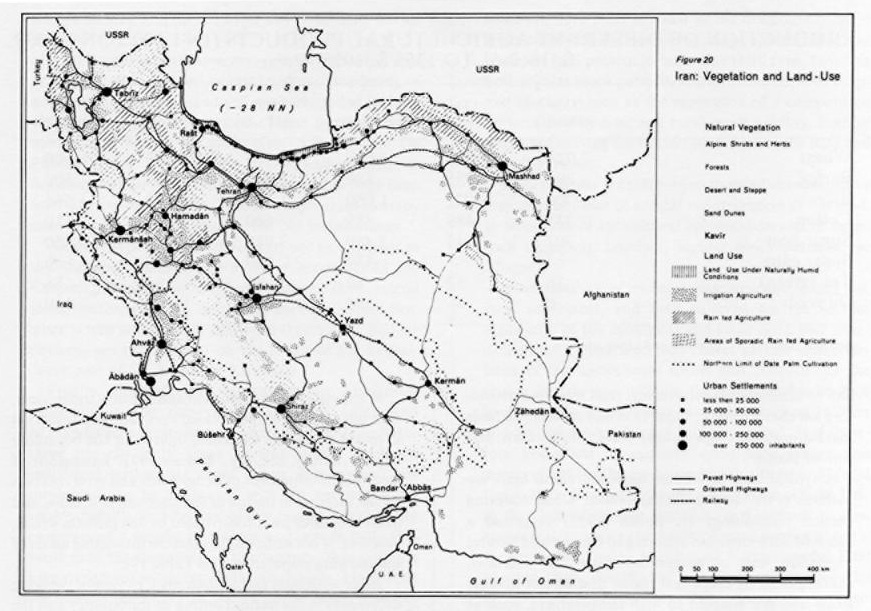
Ecological foundations of Iranian agriculture. Limited availability of agriculturally usable soils and the lack of water are the most important natural barriers for agriculture in Iran. Due to topography and unfavorable climate, only the mountainous north, northwest and west receive sufficient precipitation to carry out spatially extended agriculture. That the agriculturally usable land is limited is shown by the survey by Pabot (1967), according to which only 15 per cent may be considered as farmland and another 25 per cent of the total land of the country as rangeland. The biggest part of the country (approx. 50 percent) is sterile desert or desert-steppe, which may be usable only for periodic pasturing, while the rest is mainly degraded forests.
The agriculturally usable lands of Iran can be divided into four categories:
1. Areas of intensive and widespread natural irrigation agriculture are characterized by adequate precipitation and natural water potential. In Iran, only the Caspian lowlands can be considered of this type. Gīlān and western and central Māzandarān receive extensive precipitation (up to 2,000 mm) and are covered by such a dense network of brooks, ravines, and rivers that the whole strip between Āstārā east to the great delta fans of the Bābol, Harāz, Taǰan, and Tālār rivers in central Māzandarān are characterized by intensive agricultural land use.
2. Areas of dry farming are the most characteristic and can be found in most parts of the country. Grains are grown on the basis of winter rains without additional irrigation; such lands are found especially along the mountainous fringes of the central Iranian plateau between Azarbaijan, Khorasan, and Fārs (cf. Bobek 1951). The plateaus of central Iran, as well as the eastern and southeastern parts of the country, are so arid that agriculture can only be carried out by irrigation.
3. Areas of artificial irrigation, typical for much of the central Iranian plateau, are characterized by relatively small patches of intensive agricultural land use amid unused or little used environments. There are different forms of artificial irrigation (see Ābyārī). The oldest form, still common, is to divert river water; equally common is the canalization of springs and brooks, especially along the foot of high-rising mountains. Most famous and ingenious of all forms of artificial irrigation in Iran is the capture of circulating ground water by means of qanāts (q.v.). Dam-regulated irrigation, although known since Achaemenid and especially Sasanian times, has grown in significance in recent years. So has the large-scale construction of wells, due to which many qanāts have dried up.
4. Pasture and rangeland, in terms of spatial distribution, represent the most common form of land use; animal husbandry is carried out both by the farming and the tribal population. Areas of animal husbandry cover, horizontally as well as vertically, the fringe areas of dry farming and include the dry farmed lands themselves. The fallow fields serve as stubble pasture, thus receiving a natural manuring. Of special importance is the animal husbandry in the high mountains beyond the limits of agriculture. Here grazing occurs not only on slopes too steep for agriculture but even more in those parts which, due to long snow cover or short vegetation period (i.e., at approximately 2,400 to 2,600 m altitude), can not otherwise be used.
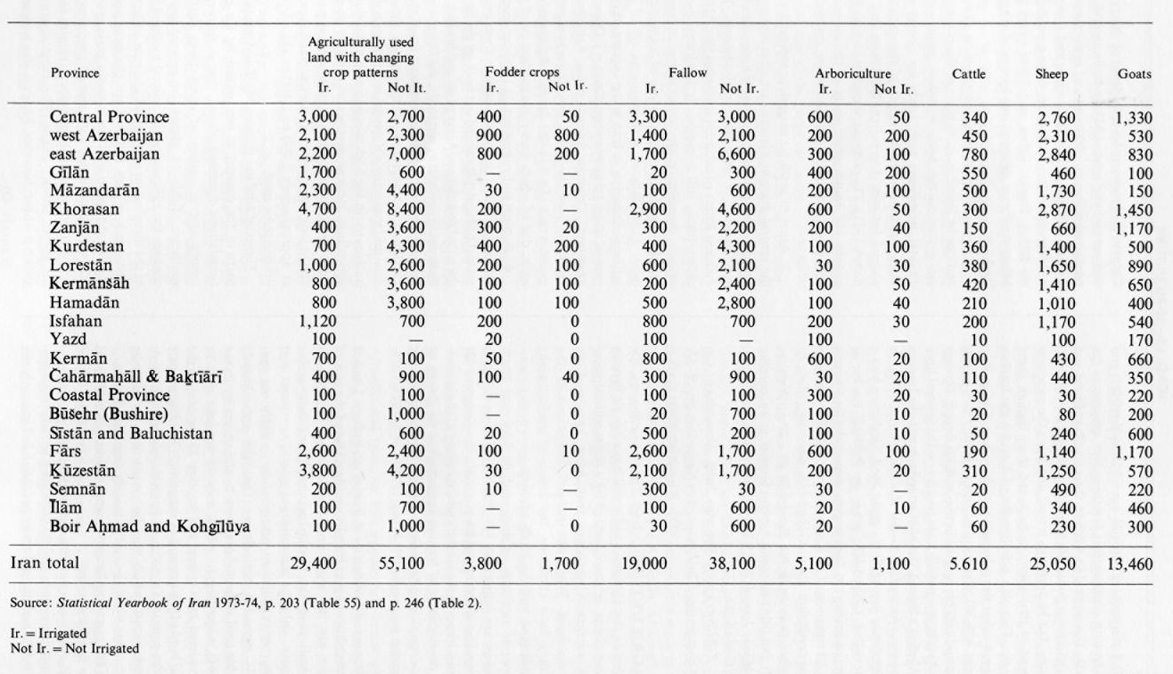
Forms of land use (Figure 20). Land use in different parts of the country is determined by the ecological foundations described above; thus it decreases in intensity and in variety of crops from northwest to southeast. TABLE 18 shows, in general terms, these changes for agriculture and animal husbandry, as well as the distribution of irrigated and non-irrigated lands. The areas of dry farming are characterized by the regular change in land use between grain growing and fallow. In accordance with annual precipitation there are two dominant rotation cycles: (a) grain : fallow, and (b) grain : fallow : fallow. The most common grain grown is wheat; however, barley is also widespread and is especially common in mountain areas. Other plants are very seldom grown, because under the harsh conditions of dry farming they barely survive. Thus the character of the dry-farmed agricultural landscape is rather monotonous, and the transition to the adjoining natural steppes is often hardly visible, especially after harvest.
The cultivation of the land is still done today in traditional ways. Wooden plows, drawn by donkeys, mules, or oxen scratch only the surface of the soil. Seeding is done by hand, as is the harvest, in which the use of sickles is still common. Threshing and winnowing are done with old-fashioned instruments such as threshing sleds. Huge threshing floors at the fringe of the villages are typical for almost all villages in central Iran and in many mountain villages. Fallow land, which covers, according to the prevailing rotation cycle, between 50 percent and 66 percent of the agricultural land, is the basis of a sometimes important rural animal husbandry. Sheep, goats, and cattle use the stubble fields close to the villages. During the winter they are kept in (sometimes subsurface) stables.
Characteristic patterns of land use in the areas of natural irrigation agriculture in Gīlān and Māzandarān include permanent crops such as tea and citrus fruits. Among the annual crops rice, cotton, wheat, and tobacco are most important; fallowing is little practiced. Gīlān and central Māzandarān are dominated by the cultivation of rice, which is grown almost every year on the same fields. Eastern Māzandarān has a rotation of cotton and wheat as its predominant two-year rotation cycle; sunflowers have been added to this traditional land use pattern in recent years.
The greatest variety of crops grown and of rotation cycles can doubtlessly be found in the oasis cultures, i.e., in the areas of artificial irrigation agriculture. Size and location, height, the form of irrigation, as well as the location of the oases in terms of market availability and other similar factors, determine their land use. Cultivation in the qanāt oases covers almost the entire range of traditional crops—grains, fruits and legumes, fodder crops—but also industrial plants such as opium, henna, or tobacco. In areas where frosts do not occur the date palm is the most characteristic representative of irrigation agriculture. In contrast to the qanāt oases (although perhaps similar in appearance), the mountain fringe oases have a different land use, mostly due to altitude and the consequent climatic differences. Most common are fruits such as apples and pears, nuts, potatoes and legumes, and flowers adapted to temperate conditions. The greatest variety of land use, however, is to be found in the great river oases of central Iran, the oasis of the Zāyanda Rūd being the best example. Here multicropping is very common. Besides poplar trees, which flank the borders of many irrigation ditches and which are used both as building material and in furniture manufacturing, fruit trees and viticulture are characteristic. Close to urban centers one finds market-oriented crops—sugar beets, alfalfa, corn, and similar plants.
A typical trait of Iranian agriculture and land use patterns is its vertical differentiation. While adapting Persian terminology H. Bobek (1952) suggested a fourfold differentiation applying to climate and natural vegetation and to human land use: (a) Garmsīr, characterized by crops and plants that do not tolerate frosts and are adapted to high temperatures, such as dates, sugar cane, sorghum, citrus fruits. (b) Medium range, whose plants require warm temperatures, but have frost tolerance; typical representatives are a number of fruit trees (e.g., figs, pomegranates, apricots, peaches), cotton, rice, tobacco, sesame, and the grape vine. (c) Sardsīr, with plants and crops predominantly of temperate climates—grains (except rice and sorghum), potatoes, and many fruits, such as cherries, apples, and plums. The upper limit of the Sardsīr is identical with the climatically determined upper limit of grain growing (up to 2,900 m.). (d) Sarḥadd, area of rural or nomadic animal husbandry.
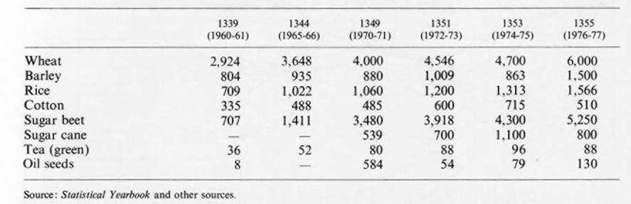
In spite of several ecological and cultural constraints, Iran has considerably increased agricultural production in recent years. For estimated figures for the beginning of this century, see, e.g., Bharier 1971. Extensions of land use, development of better seeds and crop rotation cycles, increase in the use of fertilizer and pesticides, and other measures have contributed to this growth, which, however, is not sufficient to meet the increasing needs of the growing population (see Table 19).
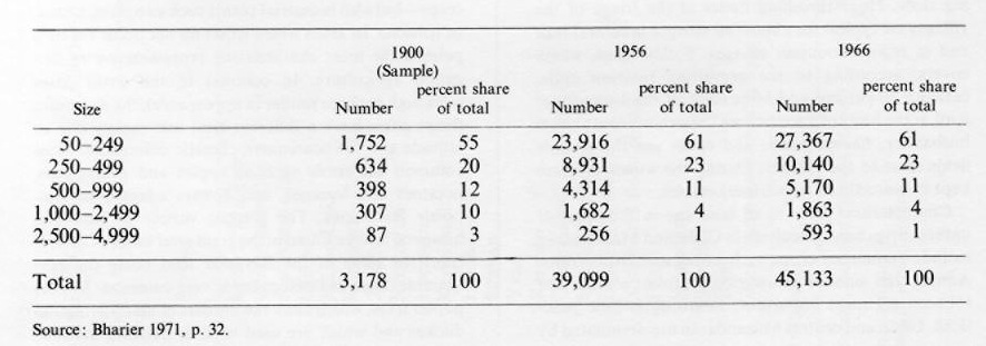
Rural settlement and field patterns. In view of the great differences in the natural setting of the country and the impact on agriculture, rural settlements show great diversity in location, distribution, size, and physiognomy. Most of the 40,000 to 50,000 villages have fewer than 250 inhabitants (Table 20).
The most common form of rural settlement is the clustered village, an irregular agglomeration of farmsteads. Sometimes, especially in larger villages, the buildings are clustered around a central open market, which may even have a little mosque, a tea house, and one or several shops. All forms of private and public services are usually missing. Typically, especially in cases of irrigation agriculture, the settlements border the arable land and do not cover any potentially usable area.
In many parts of the country, primarily in areas that in the past were exposed to raids and the plundering of nomads, villages were and still are surrounded by high walls and protected by towers. These fortified settlements, also known as qaḷʿa (fort) villages (see De Planhol 1958, Turri 1964), are nowadays without function, so that many of the ramparts either have been torn down or are decaying. Modern extensions in many cases have been made outside the old fortifications.
Another type of rural settlement, not as common as the clustered settlement but found especially in the Caspian lowlands, is the linear village. They extend along the former shore lines of the ancient Caspian Sea, when it was at a much higher level than today. Similar patterns are to be found on the levees of the Šaṭṭ-al-ʿarab and of the Kārūn in Ḵūzestān.
Finally, isolated rural settlements are numerous, especially in the rice-growing areas of Gīlān and Māzandarān. According to our present knowledge these are the only areas of Iran where dispersed individual settlements occur. Their development has doubtlessly to be connected with the special topography, botany, and history of this region, which never experienced nomadic intrusions and was densely forested until the beginning of this century, thus giving a kind of natural protection to its inhabitants. Many such settlements date only to the 1920s or 1930s, and the process of agricultural colonization is still going on.
Special forms of rural settlements include temporarily inhabited villages found in many nomadic territories, as well as in those high mountains that are grazed by the flocks of the villagers. Many of these villages serve as a kind of summer refuge for the inhabitants of low-lying and heat-affected areas such as the Caspian lowlands, the margins of the central Iranian deserts or Balūčestān, the Alborz and the Zagros; the central Iranian mountain ranges are also often characterized by this type of periodic settlement.
Iranian field-patterns. The fields, the most prominent physiognomic feature of any rural area besides the settlements, are characterized by three prevailing systems of field patterns—blocks, small strips, blocks and strips. Bobek’s rent-capitalistic interpretation holds that each of the three forms expresses a distinct socio-economic situation. The irregular block fields are interpreted as being typical for regions where rural small-holders who own their own lands predominate. This pattern is especially widespread in ecologically unfavorable or topographically inaccessible regions such as mountains, but it is also typical for many villages in the immediate neighborhood of cities and for their specific forms of intensive agriculture. In contrast, the system of strip fields is considered to be connected with dominance of landlordism and large land ownership. Due to the annual redistribution of land among the sharecroppers (see the following section on traditional socio-economic structures), the strips have proved to be an easy way to divide farmlands and therefore have been adapted as the dominant form in connection with sharecropping; they represent the most common field pattern in Iran. The third type, covering both regular block patterns and mixtures between strips and blocks, is seen as the expression of a competition between landlordism and rural small holding, both of which are striving for the ultimate right in the land and its cultivation.
Field patterns are still subject to rapid changes; there may also be cases of annual redistribution of the land. In situations of agricultural colonization and of large-scale irrigation, however, regular block patterns are adopted.
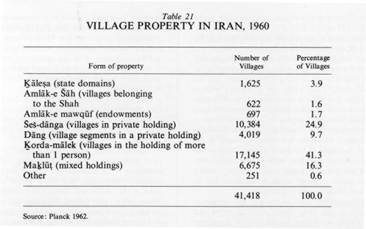
Traditional social and economic structure. Land use, rural settlement, and field patterns are the surface expression of the ecological and socio-economic foundations of agriculture; they reflect certain characteristics of the agricultural forms and potential of the region but do not indicate the social and economic background and the conditions under which agriculture and animal husbandry are being practiced. It is therefore important to consider rural land tenure and property rights. The traditional basic situation of rural Iran is that of inequality in the distribution of land. Due to the lack of reliable statistics, it is difficult to give accurate data about the forms of rural property; but a survey by the Iranian Ministry of Agriculture for 1960 (quoted from Planek 1962) may serve to show the general trend (Table 21). The separation between ownership and land use is a basic obstacle for the development of rural Iran. Moreover, there is no doubt that the land reforms from 1962 onwards have been uncoordinated and without thorough planning; the present problems of Iranian agriculture are also to be seen as an outcome of the recent changes of traditional social structure.
Rural land tenure. The traditional forms of land tenure in the rural sector reveal typical aspects of the rent-capitalistic character of the agricultural production and rural income distribution. The organization of agricultural production may be seen under two aspects: first, the traditional property rights in soil and water and other factors of agricultural productivity and, second, the traditional relationships between owner and worker of the land. These two aspects have to be subordinated to the four essential factors for agricultural production: soil, seed, draft animals and tools, and human labor. (Irrigation is at times a fifth equal factor). Each of these four or five production factors can further be analyzed into sub-units. For example plowing, tilling, harvesting, threshing, and winnowing may pertain to different persons, who will be compensated in corresponding portions of the 20 percent harvest share allotted to the production factor “human labor.” Thus according to Bobek (1961, p. 235) “the concept of the enterprise or operating unit begins to dissolve, under such a system, into a series of individual titles, or rather tasks, and corresponding claims on income.”
Property rights. Property rights in land are predominantly of two kinds: They are either attached to certain parcels of land, or they are “ideal titles,” i.e., imaginary shares or allotments from the total agriculturally used lands, waters, or whatever. In the first case, the relationships between the owner and worker of the land are clear. Where owner and worker of the land are one and the same person (ḵorda-mālek), all benefits of work and management fall to him alone. This case, however, has been the exception in traditional rural Iran, because landlordism and large landed properties have always prevailed. In cases where only one landlord owned a village and its land, organizational problems hardly arose. Agricultural production was performed by individual sharecroppers or, more often, by groups of sharecroppers (see Bona), who received income shares according to the proportion of the production factors which they contributed to the production process. But in the second case, the situation is much more complicated, since several families and their members, as well as individuals, shared in the land titles. Village land became further divided in case of the death of one of the proprietors; all heirs received parts of the property of the deceased, according to the Islamic laws of inheritance. The result was, in most cases, that property rights in a village, in certain parts of a village, or even in single fields or gardens were almost atomized among a great number of proprietors who only knew the share, not the hectarage of the land which they owned within the village and its boundaries. This tendency to possess not certain, regionally fixed parts of the land but shares of the total, is made possible by the custom of splitting each property or any part of it into “ideal” or “imaginary” shares or allotments. Thus, a village or a certain field could be divided, e.g., in Ḵūzestān, as follows:
village or part of it = 24 “peas”
1 pea = 24 “barleycorns”
1 barleycorn = 24 “sesame seeds”
I.e., each village or any part of it could be divided into 24 x 24 x 24 parts, implying 13,824 property titles. Under such circumstances locationally fixed land allotments are hardly possible, so that the “ideal” or “imaginary” land title has become common in many parts of the country.
Organization of production on this level of “imaginary” land holding was characterized by consideration of the whole village or the whole agricultural production process as an entity, out of which the different landowners were compensated according to their share in the whole property after deduction of the shares for the sharecroppers. Such a system demands a high amount of cooperation with subordination to the principle of collective land ownership. However, this system with its ideal property titles means that no landlord has ever been interested in reinvesting any of his profits into the improvement of the land or other agricultural production factors. Thus robber farming and wasteful exploitation of the soil have been permanent consequences of rural land use in Iran for centuries or even millennia (cf. Lambton 1977).
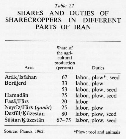
Sharecropping practices. Most agricultural lands in Iran have traditionally been worked on a sharecropping basis. The strict separation of land ownership and land cultivation must therefore be considered as the organizational prototype of agricultural production with far-reaching effects both on payment and employment. The basis of all sharecropping arrangements is the division of the agricultural production process into the four or five production factors, each of which is considered to be responsible for 25 or 20 percent of the final harvest. Utilizing fundamental work by A. K. S. Lambton (Landlord and Peasant in Persia), Planck (1962) has summarized a few of the most common sharecropping practices in different parts of the country. Proportional sharing ranges from 20:80 up to 80:20 (Table 22).
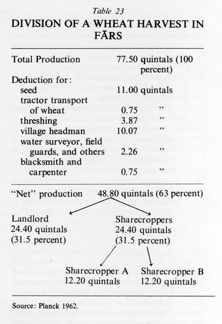
The details of the sharecropping arrangement are little known. However, the two or three detailed examples which have been published (cf., e.g., Gharatchedaghi 1967; Lambton 1953; Planck 1962) reveal that the above-mentioned surveys are rather crude generalizations and that the actual claims to parts of the harvest are much more complicated. In line with Bobek’s assumption that “the ideal of rent capitalism is attained when the sharecropping farmer does not touch more than a meager share of the work of his hands” (op. cit., p. 235), Planck (1962) could demonstrate for a village in Fārs that out of a total of 77.5 quintals only about 63 percent was available for distribution between the landlord and his two sharecroppers. The other 37 percent was deducted for claims in connection with minor production factors such as tilling and disking, for the water surveyor, and for the village headman (Table 23).
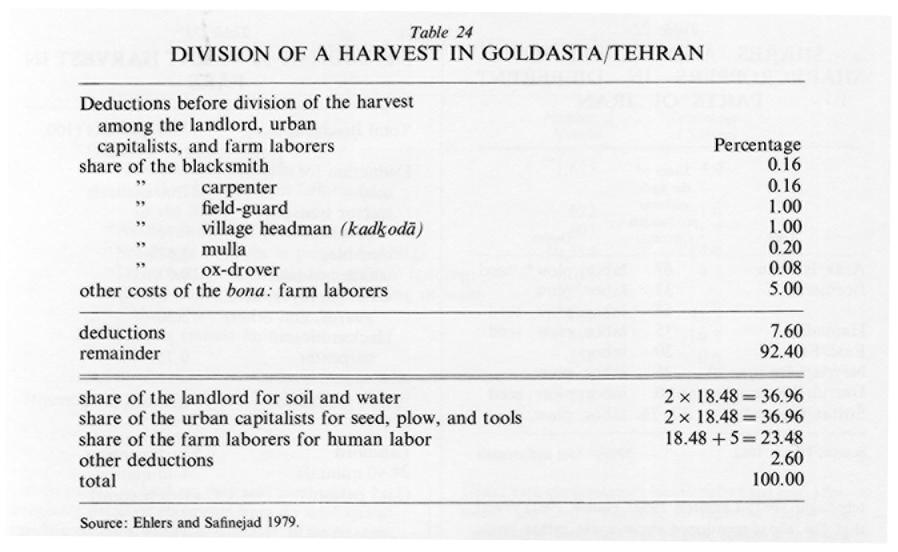
The investigations of Ehlers and Safi-nejad (1979) point in the same direction. The distribution of the winter grain (kešt-e šatvī) in the village of Goldasta near Tehran is done in two steps. First 7.6 percent of the harvest is deducted for various claims, such as shares for the blacksmith, joiner, village headman, and others. The rest is divided among the five traditional production factors, each one counting for 18.48 percent of the final productivity. These are attached to landlord and sharecroppers according to their contributions to the production process (Table 24).
In regard to the payment system and income distribution, the sharecroppers are reimbursed according to the area of land they are entitled to work. The general rule is that the size of land attributed to, e.g., each member of a bona is of almost equal size and productivity (e.g., a ǰoft, the land that a man with a yoke of oxen can work alone). But there are considerable variations from ⅛ ǰoft to two or more ǰofts per sharecropper (Ehlers 1975). These variations in size can be due to cases of inheritance, or other factors such as indebtedness of one sharecropper to another or similar matters. They are the causes of considerable differences in income among the members of a sharecropping unit, and the almost stable and stationary character of the bona structure proved in the past a restrictive factor for those who were not members of such a working unit to get access to work. Many of those not included in this system were forced either to abandon their rural living or to develop non-agricultural activities within the village (see Ḵᵛošnešīn).
The organization of sharecropping labor is even more complicated than that of income distribution (both of “ideal” landlordism and of sharecropping farmers). Sharecropping contracts are seldom made between individuals, i.e., between a single landlord and a single sharecropper. Sharecroppers organize into working units of mostly two to six members (see Bona), who work the land together. In many parts of the country (possibly in most) the total agricultural land of the village was therefore divided into several field complexes which were redistributed annually among the different working units and their members. In order to guarantee a fair distribution of land to all sharecroppers, it is a widespread practice to attach an equal number of field complexes to the different working units by lottery. Within the bona or other unit, a second lottery takes place to provide each member with his share of land. In the same way that many landlords could not and still can not point to any locationally fixed tenure rights, the sharecroppers did not have any rights to work in a fixed location. Each year they received different parts of the arable land of the village approximating the size to which they were entitled. So the sharecroppers also have no interest in putting more effort and means into the soil and its cultivation than absolutely necessary, because others, including the landlord himself, would benefit from any individual’s endeavors.
Dallāl and ḵᵛošnešīn. Completing the picture of traditional rural land tenure, two social groups are essential both for the functioning of the rent-capitalistic system of rural production and for analysis of the organization of production: the traders, dealers, brokers, and hawkers (dallāl) and the landless village dwellers (ḵᵛošnešīn). The ḵᵛošnešīns participated in traditional rural land tenure as a casual but permanent labor force; they were used as seasonal labor or at times of special demand; and they became part of the division of the production process into production factors and were compensated according to their share in that process either in kind or in money (cf. Hooglund 1973, Khosrovi 1973). Not all ḵᵛošnešīns, however, are engaged in rural activities. Quite a few make their living as shopkeepers, taxi, bus, or truck drivers, or as middlemen. They very often adopt parasitic attitudes, e.g., by selling on credit or lending money to be repaid in grain or other agricultural products. In case of non-payment, takeover of land and other properties of sharecroppers or small landlords by the ḵᵛošnešīns has been observed repeatedly.
Land reform, its aims and results. Obvious deficiencies in the productivity of rural Iran, the manifold social consequences of the unequal distribution of land, and the problems of sharecropping must be seen as the main reason for the implementation of a land reform program, the discussion of which had started by the late 1950s. In 1960 a first land reform law was passed but proved impracticable. In 1961 a new law passed parliament and became effective 9 January 1962. Its main goals were to fix the upper limit of private property at one village and to distribute confiscated lands among sharecroppers, who had to join the newly developed rural cooperatives. Landlords were to be refunded for the expropriated lands in cash or industrial stocks. The organizational structure of land use and cultivation remained untouched during this first phase of land reform. Limiting rural property to the size of one village meant the immediate availability of 16,333 villages and 1,001 other estates for redistribution; according to Planck (1975), 777,825 farmers received title to newly assigned lands. Further restrictions on the maximum size of landholdings marked the inauguration of the second phase of the land reform program on 25 July 1964. The upper limits of rural land holdings were defined according to the following system:
| land in the: | upper limit (ha) |
| provinces of Ḵūzestān, Balūčestān, and Sīstān | 150 |
| other provinces | 100 |
| immediate neighborhood of the provincial capitals (except Kermān, Zāhedān, and Sanandaǰ) | 50 |
| Turkoman and Moḡān steppes of northern Iran, as well as lands in Gīlān and Māzandarān (except for rice lands) | 40 |
| immediate neighborhood of Tehran, Varāmīn, Damāvand, Ray, and Karaǰ | 30 |
| rice lands in Gīlān and Māzandarān | 20 |
While more than one million farmers benefited from this second phase of the land reform and its regulations (for details see Aresvik 1976, Lambton 1969, Planck 1975), in 1968 a third addition to the existing laws was proclaimed: The maximum size of property was determined by the amount of land which the proprietor and his family could work by themselves. With minor additions and corrections, concerning, e.g., public and religious endowments and their distribution among farmers, one may say that by 1972 the land reform program seemed to have ended. The important results of the first years of the land reform can only be summarized here—initial increases in the income of land recipients due to the abolition of sharecropping, the psychological and political awakening of the rural population, which for the first time had the right to determine land use and crop rotation patterns. But the land reform was not connected with increases in agricultural productivity because of the perpetuation of traditional forms of tools, cultivation techniques, and the absence of aid through cooperatives and agricultural extension services. A special problem turned out to be the Islamic laws of inheritance, as a result of which many of the new small holdings were fragmented only a few years after their foundation. It seems that this factor has contributed considerably to the rapid decrease of viable farm units. Renewed indebtedness of farmers to urban shopkeepers and former landlords and the final takeover of their lands by these persons became common.
In view of these negative results and because of almost stagnant agricultural productivity, it became obvious from 1972 onwards that a new agricultural policy was necessary. A period began which was characterized by the dissolution of the majority of small farm holdings created under the land reform and their consolidation into larger production units. This movement has been termed the “reintegration phase of the Iranian land reform” (Planck 1975). Four types of large-scale agricultural enterprises came into existence after 1970: farm corporations or “agricultural shareholder companies;” agricultural production cooperatives; privately owned agribusiness and agroindustry companies; and government-owned agroindustries. The main goal of this restructuring of the agricultural scene was the establishment of large-scale agriculture with the aim of extensive use of agricultural machinery and the increase of productivity. The overall strategy of this new policy becomes apparent in the aims stated by the Fourth National Five-Year Plan for 1968-72: the encouragement of increased production of commodities which are presently imported to meet domestic consumption; the encouragement of private investment and emphasis on public investment in areas which have a larger production potential; the establishment of agricultural joint-stock companies by farmers who have acquired land on cooperative principles; the mobilization of capital at present widely dispersed in rural and urban areas and the encouragement of capital-holders to establish large-scale production units or to participate in investments in units which aim at mass production for marketing purposes; the expansion and strengthening of cooperative societies by increasing their capital and the provision of means for guiding and training their directors and members; the adoption of policies that will ensure the maximum utilization of the investment made by the private sector for performing services at present undertaken by the government; the expansion of modern agricultural techniques at the rural level by fully utilizing the results obtained from practical and scientific agricultural research work; the utilization on a large scale and with modern technology of dam-irrigated land, by encouraging the private sector, and in the private sector, direct government initiative to establish large farming units.
Due to the revolution of 1979 these goals are no longer kept in view, but the reintegration of small holdings into larger units had been quite effective by 1978 (cf. Table 25).
The impact of these new regulations may be summarized as follows. Positive effects of the farm-corporations are the rational cultivation of the land with a wider range of products grown and a higher productivity through the use of machinery, fertilizers, and pesticides. Negative aspects include the possibility of strong government influence through government appointed directors of these corporations, problems of this externally installed management because of their ignorance of local customs and traditions, a far-reaching loss of individual responsibility of the shareholders, and problems of unemployment because of the heavy mechanization of these large farm units. While there is no doubt that many farm corporations succeeded in achieving a higher productivity, this is more true for agroindustries and agribusiness enterprises. Their negative effects are, however, much more prominent. They include, e.g., the dissolution of a great number of individual small holdings, because agroenterprises were established on village lands, the destruction of many villages and the resettlement of their population, an even higher number of unemployed farmers and severe social and economic setbacks for the rural population, who were forced to migrate to the bigger cities or to find a living as farm laborers or similar employment in the rural neighborhood (cf. Ehlers 1979).
Consequences of land reform and present status of agriculture. Due to the changed political situation since 1979, it is difficult to judge the present status of Iranian agriculture properly. However, it seems possible to mention the main consequences of land reform. In regard to the socio-economic structure of the rural population one must state an extremely increased social and regional mobility of the rural population with corresponding results of rural emigration and urban growth. Within the rural scene there has been a very strong stratification of the rural population, with the development of new “classes” within the villages (Planck 1979), and a strong impact on the nomadic population (Stöber 1979). In regard to land tenure there seems to be a strong tendency towards the renewed consolidation of lands in the hands of fewer and fewer landlords through the mechanisms of indebtedness and similar rent-capitalistic features. The economic consequences are to be seen under two aspects. First, there is no doubt that, especially in the early phases of the land reform, many of the new small-holder landlords experienced a considerable increase in their incomes because of the abandonment of sharecropping duties. This meant an increased demand for consumer goods previously not available to them. The splitting of newly created farms, however, very often caused renewed indebtedness, loss of property, and newly developed dependencies on former landlords and urban shopkeepers, moneylenders, etc. This resulted in the aforementioned development of a new “class” structure in many villages. Second, the demand for higher productivity led to the creation of the reintegrated large-scale enterprises, which doubtlessly achieved their goal of a higher agricultural production, but were so destructive in their social results that their overall effect has to be questioned. Concerning the infrastructural development of the rural scene, positive results included the creation of quite a number of “primary” villages in connection with the establishment of cooperative centers, schools, public baths, and similar institutions. However, it is obvious that the land reform failed to bring about large-scale rural economic development in terms of creating rural service centers with shops and administrative institutions. Instead, the rural towns and cities were the real profiteers in all social and economic developments in rural Iran. The fact that the gap between rural and urban development has been widening since the implementation of the land reform program may be considered as the best proof of this statement. See also Ābyārī, Kešāvarzī, Land Reform.
Bibliography
O. Aresvik, The Agricultural Development of Iran, New York and Washington, 1976.
J. Bharier, Economic Development in Iran 1900/1970, London, New York, Toronto, 1971.
H. Bobek, “Die Verbreitung des Regenfeldbaus in Iran,” Geographische Studien (Festschrift für J. Sölch), Vienna, 1951, pp. 9-30.
Idem, “Beiträge für klimaökologischen Gliederung Irans,” Erdkunde 6, 1952, pp. 65-84.
Idem, “Die Hauptstufen der Gesellschafts- und Wirtschaftsentfaltung in geographischer Sicht,” Die Erde 90, 1959, pp. 259-98; tr., “The Main Stages in Socio-Economic Evolution from a Geographical Point of View,” in P. L. Wagner and M. W. Mikesell, Readings in Cultural Geography, Chicago, 1961, pp. 218-47.
Bobek, “Zum Konzept des Rentenkapitalismus,” Tijdschrift voos Economische en Sociale Geografie 65, 1974, pp. 73-78.
Idem, “Entstehung und Verbreitung der Hauptflürsysteme Irans—Grundzüge einer sozialgeographischen Theorie,” Mitteilungen der Österreichischen Geographischen Gesellschaft 118, 1976, pp. 274-304; 119, 1977, pp. 34-51.
E. Ehlers, Traditionelle und moderne Formen der Landwirtschaft in Iran. Siedlung, Wirtschaft und Agrarsozialstruktur im nordlichen Khuzistan seit dem Ende des 19. Jahrhunderts (Marburger Geogr. Schriften 64), Marburg, 1975.
Idem, “Social and Economic Consequences of Large Scale Irrigation Developments: The Dez Irrigation Project/Khuzestan Iran,” in E. B. Worthington, ed., Arid Lands Irrigation in Developing Countries, Environmental Problems and Effects, Oxford and New York, 1977, pp. 85-97.
Idem, “Die iranische Landreform—Voraussetzungen, Ziele und Ergebnisse,” in H. Elsenhans, ed., Agrarreformen in der Dritten Welt, Frankfurt/Main, 1979.
Idem and J. Safi-nejad, “Formen kollektiver Landwirtschaft in Iran: Boneh,” in E. Ehlers, ed., Beiträge zur Kulturgeographie des islamischen Orients (Marburger Geogr. Schriften 78), Marburg, 1979, pp. 55-82.
C. Gharatchedaghi, “Distribution of Land in Varamin. An Opening Phase of the Agrarian Reform in Iran,” Schriften des Deutschen Orient-Instituts, Materialen und Dokumente, Opladen, 1967.
G. Goodell, “Agricultural Production in a Traditional Village of Northern Khuzestan,” Marburger Geogr. Schriften 64, 1975, pp. 243-89.
E. J. Hooglund, “The Khwushnishin Population of Iran,” Iranian Studies 6, 1973, pp. 229-45.
N. R. Keddie, “The Iranian Village Before and After Land Reform,” Journal of Contemporary History 3/3, 1968, pp. 69-91.
K. Khosrovi, “Les paysans sans terre: les khochnechin,” Sociologia ruralis 13, 1973, pp. 289-93.
A. K. S. Lambton, Landlord and Peasant in Persia, Oxford, 1953.
Idem, The Persian Land Reform 1962-1966, Oxford, 1969.
Idem, “Aspects of Agricultural Organization and Agrarian History in Persia,” Wirtschaftsgeschichte des Vorderen Orients in islamischer Zeit, pt. 1 (HO 1, 6, 6), Leiden and Cologne, 1977, pp. 160-87.
H. S. K. Lodi, “Preharvest Sales of Agricultural Produce in Iran,” Monthly Bulletin of Agricultural Economics and Statistics 14/6, 1965, pp. 1-4.
H. Pabot, “Pasture Development and Range Improvement Through Botanical and Ecological Studies,” Report to the Government of Iran (FAO 2311), Rome, 1967.
U. Planck, “Der Teilbau im Iran,” Zeitschrift für Ausl. Landwirtschaft 1, 1962, pp. 47-81.
Idem, “Die soziale Differenzierung der Landbevölkerung Irans infolge der Agrarreform,” in G. Schweizer, ed., Interdisziplinäre Iran-Forschung. Beiträge aus Kulturgeographie, Ethnologie, Soziologie und Neuerer Geschichte. Beihefte zum Tübinger Atlas des Vordern Orients, Reihe B (Geisteswissenschaften), Wiesbaden, 1979.
X. de Planhol, “Les villages fortifiés in Iran et Asie Centrale,” Annales de Geographie 67, no. 361, 1958, pp. 256-58.
G. Stöber, “Für sozioökonomischen Differenzierung des Afshar im Raum Kerman,” in G. Schweizer, ed., Interdisziplinäre Iran-Forschung (above).
E. Turri, “Villagi fortificati in Iran e Afghanistan,” Rivista Geografica Italiana 71, 1964, pp. 20-34.