

i. HISTORICAL GEOGRAPHY
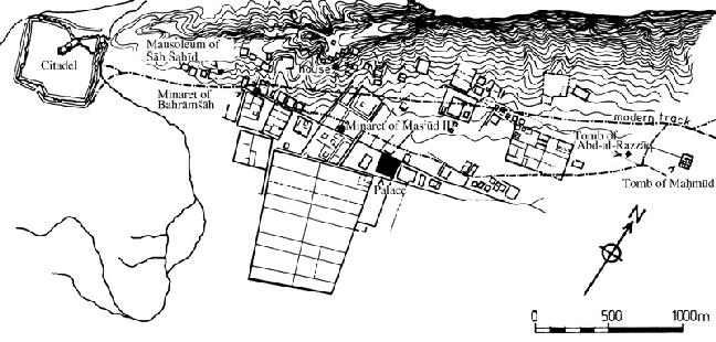
The town of Ḡaznī dominates the route which, from Kabul to Qandahār (Kandahar), skirts southward around the central highlands of Afghanistan and over easy passes, either through the Gardīz and Ḵōst basins, and over the Batay pass and the Točī valley, or further south through the Gomal valley, which provides a relatively easy access to the middle course of the Indus. At the southernmost end of a jagged plateau joining the highlands, the site of the present city is reached over a steep hill dominating the Ḡaznī river, which flows from north to south towards the Kaṭawāz (Āb-e Īstāda; q.v.) basin. Here a small market-town was established a long time ago, perhaps already mentioned by Ptolemy (VI, 18, 4: Gázaca or Gāzaca), and at any rate clearly identifiable with the Ho-si-na where the Chinese pilgrim Hsüan Tsang stopped in 629 (Beal, II, p. 283). In the 10th century, Ḡaznī was described in Arabic geographical accounts as a busy commercial center securing Central Asian and Iranian relations with India (Le Strange, Lands, p. 348). Eṣṭaḵrī (q.v.), who described it as having a river but no gardens, wrote that no other city in the region was richer in commerce and merchandise, for it was the “port” of India (p. 280). Ebn Ḥawqal (q.v.), whose Ketāb ṣūrat al-arż was completed in 988, but who probably visited the region in 969, also knew it as a trading center with India, frequented by numerous Hindu merchants. But he describes it as having greatly suffered since its siege and capture in 966 (in fact 961) by Alptigin (q.v.), the first Turkish governor who became almost autonomous in the region (Bosworth, Ghaznavids, pp. 37-38). It was, however, from this period on that the city greatly expanded, ruled by a Turkish soldiery from which there soon emerged (with Sebüktigin in 977) the Ghaznavid dynasty. The city’s commercial function was enhanced by its role as a capital, as the headquarters of regularly organized expeditions sent on the conquest of India, and as a major cultural center. With its by now considerable population, the city had largely expanded towards the hills and the plateau, on both sides of the river, and also into the valley and the plain, as attested by the considerable ravages caused by a flood in 422/1031 in the markets and caravansaries (Bosworth, Ghaznavids, p. 139, quoting Bayhaqī). The water supply for the city and the irrigable lands necessary for its provisions was secured by constructing large dams which have survived and been renovated recently (see BAND; Balland, p. 241).
The city’s prosperity came to an abrupt and brutal end when it was sacked and set on fire in 1151 by the Ghurid sultan ʿAlāʾ-al-Dīn Ḥosayn Jahānsūz (q. v.). The return of the last Ghaznavids brought a degree of renewal for a few decades, and Yāqūt, who reported on events on the eve of the Mongol invasion, still considered it a great city (Yāqūt, tr., p. 406). However, the Mongols dealt the final blow and destroyed it again in 1221. In 1332 or 1333, Ebn Baṭṭūṭa reported that “most of it is devastated.” The inhabitants spent the winter in Qandahār because of the cold. From then on the bulk of the population moved south of the old capital, to a “small town on a river flowing under the citadel,” where the traveler stayed (Ebn Baṭṭūṭa, III, pp. 88-89). This must already have been the present “old town,” on a hill about a hundred meters above the left bank of the river where it enters the plain. From then on the descriptions remain unchanged for several centuries. Ḡaznī became merely a modest local center. Bābor (q.v.), in 1504-5, considered it as “a very humble place,” merely surviving because of the river which fed four or five mills and as many farming villages. He found it strange that the masters of Hindustan and Khorasan could have made it their capital (Bābor-nāma, tr. Beveridge, pp. 218-19). This was also the impression conveyed by the first European travelers in the 19th century. In 1832, according to Charles Masson, it consisted of no more than about a thousand houses, and its bāzār was mediocre and poorly stocked (Masson, II, p. 219). This is confirmed by Godfrey Thomas Vigne (p. 127) who, in 1836, also mentions a “modest” bāzār (see also Mohan Lal, pp. 329-30, who passed through in 1833, and Bellew, 1862, p. 185 ff.). One of the main functions of the city, perched on top of its hill and surrounded by a wall, was to house a relatively large garrison of about two thousand men (Vigne, pp. 122-23, 127), an essential element for controlling the road and the regional tribes. However, since the town had moved to the edge of the plateau after abandoning the Ghaznavid city, it was dominated by the surrounding hills and therefore unable to resist a proper siege (Masson, p. 221).
A new phase in the city’s development started in the 1920s, with the beginnings of the country’s modernization and the growth of road transport. Cars began to appear on the Kabul-Qandahār route, which runs along the foot of the village, on the other bank of the river. Ḡaznī then became a stopping-off point. A suburb rapidly appeared along the road, with a new bāzār for supplying travelers and vehicles; but it was still, until 1958, insignificant in comparison with the old city. At that date, the Ministry of Public Works started building a new city in the plain south of the old one on plots of 800 to 1,000 sq. m. This included an administrative center and public buildings, with new bāzārs on both sides of the river and a large Friday mosque. It rapidly monopolized all the central functions, which now deserted the old city. From the early 1970s on, the shops in the bāzārs of the old city became dilapidated or closed down, and crossroads (čahār sūqs) turned into empty spaces. Only the military quarter and the citadel remained unchanged. However, poor immigrants began to settle in the old city quarters, and by 1972, this area contained four-fifths of the town’s homes, with a density of some 700 inhabitants per hectare, as against 60 to 80 inhabitants per hectare in the new city. Since 1970, however, the latter has also become more densely populated, and the newly built plots have been reduced in size to 300-400 sq. m., leading to a density of about 200 homes per hectare. Apart from the affluent classes, who have all left the old city, these new quarters house newcomers (artisans and tradesmen) coming from nearby Kaṭawāz. They own a considerable part of the 2,400 or so shops, and regularly cater to the vehicles stopping on their way, as well as to the neighboring countryside. The total population of the town was in the order of 20,000. This type of urban evolution, marked by the persistence of an old city preserving a large part of its population next to a new city which has captured all its central functions, is represented by numerous towns in Afghan Turkestan (Grötzbach, 1979, pp. 26-27), but Ḡaznī is the only example in southern Afghanistan south of the Hindu Kush. This exception is evidently due to the particular morphology of the old city which, being situated on a steep hill, did not lend itself to a transformation in situ.
Bibliography
D. Balland, “Passé et présent d’une politique des barrages dans la région de Ghazni,” Stud. Ir. 5, 1976, pp. 239-53.
S. Beal, Si-Yu-Ki: Buddhist Records of the Western World, Translated from the Chinese of Hiuen Tsiang (A. D. 629), 2 vols. in 1, London, 1884.
Gazetteer of Afghanistan VI, pp. 183-201.
E. Grötzbach, “Zur jungen Entwicklung afghanischer Provinzstädte: Ghazni und Mazar-i Sharif als Beispiele,” Geographische Rundschau 27, pp. 416-24.
Idem, Städte und Basare in Afghanistan: Eine stadtgeographische Untersuchung, Beihefte zum Tübinger Atlas des Vorderen Orients B 16, Wiesbaden, 1979.
C. Masson, Narrative of Various Journeys in Balochistan, Afghanistan, and the Panjab, 3 vols., London, 1842; repr., Karachi, 1974.
E. Merçil, Gazneliler devleti tarihi, Ankara, 1989.
Mohan Lal, Travels in the Panjab, Afghanistan and Turkistaņ, London, 1846; repr. Patiala, 1971.
G. T. Vigne, A Personal Narrative of a Visit to Ghuzni, Kabul, and Afghanistaņ, 2nd ed., London, 1843, repr. Lahore, 1982.
Yāqūt b. ʿAbd-Allāh Ḥamawī, Moʿjam al-boldān, tr. C. Barbier de Meynard as Dictionnaire géographique, historique et littéraire de la Perse…, Paris, 1861.