

TAMIŠA WALL, an at least 11-km-long Sasanian wall west of present-day Sarkālata village in Gorgān, crossing the coastal corridor at the southeast corner of the Caspian Sea. It is so named after the historical town of the area (Ḥodud al-ʿālam, tr. Minorsky, p. 134; verses in the Šāh-nāma of Ferdowsi, cited in Dehḵodā, p. 965; Bivar and Fehérvári, Figure 1).
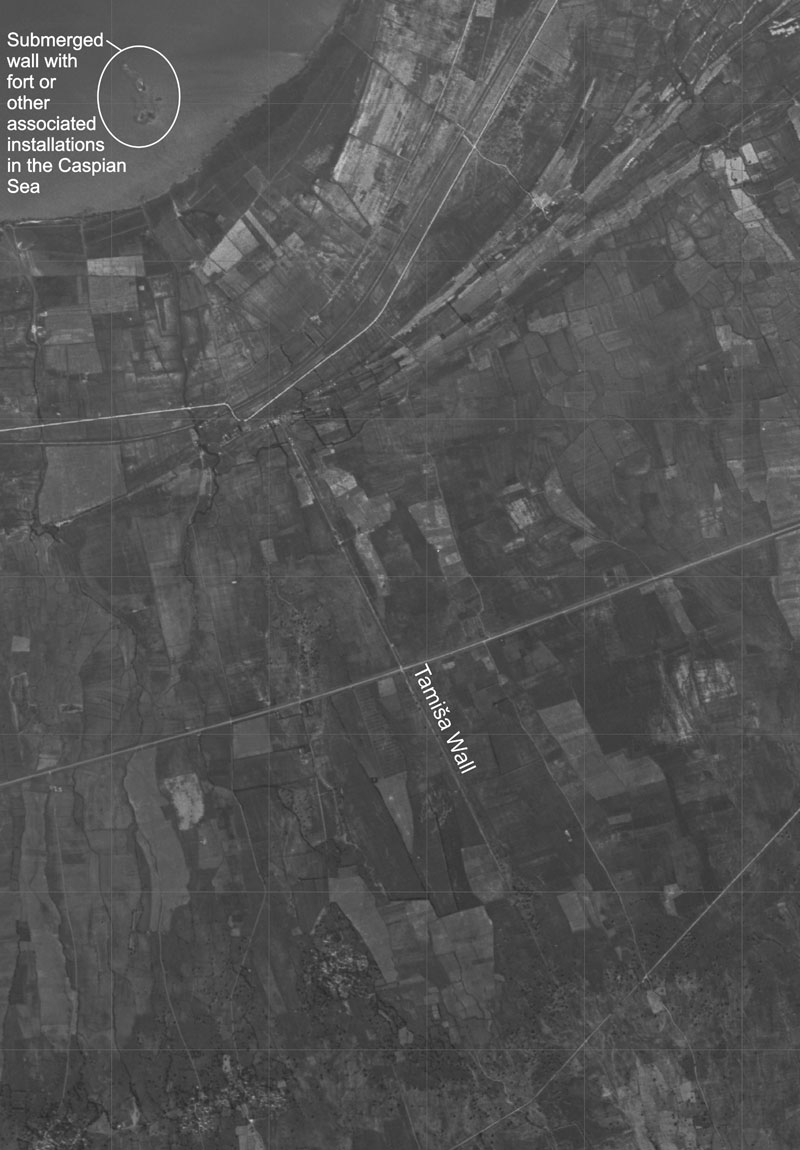
The northernmost known point of the wall, now flooded due to a rise in the water table of the Caspian Sea, has recently been traced by a team of divers led by Julian Jansen Van Rensburg, Francesco Caputo, and Hamid Omrani Rekavandi at lat. 36°48.863′ N, long. 54°01.030′ E. From here the wall runs in a fairly straight alignment to lat. 36°45.597′ N, long. 54°03.112′ E, but changes its direction as it approaches the mountains. Ascending a steep ridge, it terminates at a mound, probably the remains of a tower (robbed of its bricks), at lat. 36°43.321′ N, long. 54°03.687′ E. The wall was built of fired square bricks, produced in rectangular kilns along the wall (Nokandeh et al., pp. 153-56; Sauer et al., 2013, pp. 244-51). In the plain, a linear earthwork with brick revetment formed its base. An approximately 2.2 km-long section of this earthwork is preserved under a modern field track, to a height of up to 2.80 m. The wall itself has been destroyed through brick robbing, though a collapsed section in the Caspian Sea survives as a substantial bank of brick rubble. A ditch to the west of the wall provided the material for the earthwork and the fired bricks. Continuing to lat. 36°42.595′ N, long. 54°04.059′ E, it probably also supplied water for brick production.
French archeologist Jacques de Morgan, director of Délegations Archéologiques Françaises in Iran (1897-1912), recorded parts of the wall (de Morgan, 1896-97, IV, pp. 131-32; idem, 1895). In 1964 A. D. H. Bivar and Géza Fehérvári explored the relevant historical sources, as well as the physical remains of the wall and associated sites. As a part of their pioneering project, they excavated a section through the Tamiša Wall and one trench each in the nearby Bānṣarān Fort and the citadel of the medieval town of Tamiša (Bivar and Fehérvári). An extensive archeological survey of the Tamiša Wall in 2001, directed by Jebrael Nokandeh and Hamid Omrani Rekavandi, led to the discovery of the wall’s continuation into the Caspian Sea and its first exploration by underwater archaeologists. A joint expedition from the Iranian Center for Archaeological Research and the Universities of Edinburgh and Durham carried out geophysical surveys and excavations, from 2005 to 2009. The fieldwork focused on the Bānṣarān Fort, notably a three-aisled hall within, brick kilns along the wall, the wall’s terminal in the mountains, the ditch beyond and the wall’s submerged remains in the Caspian Sea. The hall could be of the late Sasanian or early Islamic period (Nokandeh et al., pp. 151-68; Omrani et al., 2007, pp. 110, 112-13; Omrani et al., 2008, pp. 166-69; Sauer et al., 2009, pp. 127-28, 130-31, 135, 141-43; Sauer et al., 2013, pp. 15-20, 244-87, 524-25, 593-99).
The southern section of the wall was guarded by the Bānṣarān Fort, enclosed in a cordon of ancillary barriers west of the main wall. An area of shallow water in the Caspian Sea, abutting the east side of the wall, probably represents the flooded remains of a second fort, like the Bānṣarān Fort on a platform. Nāranj Qalʿa, a mountain refuge 5 km south of the wall’s southern terminal and Qalʿa-ye Doḵtar, a castle with projecting towers of fired brick, 2.4 km SSW of the terminal, seem to date to the early Islamic period (Sauer et al., 2013, pp. 288-94).
A charcoal radiocarbon sample from a brick kiln dates the construction of the wall to about 402-537 CE. Ebn Rosta (p. 150; tr. Bivar and Fehérvári, pp. 36-37), writing in the early 10th century, attributed the wall to Ḵosrow I Anuširvān (531-579 CE), which may not have been far off, even if a slightly earlier date seems more probable. The occupation of the Bānṣarān Fort equally reaches back to the late Sasanian period (ca. 430-571 CE), though it appears to have been occupied into the early Islamic period. The large three-aisled hall of about 53 × 33 m in the interior may have been among the ruins seen here by Ebn Esfandiār (I, p. 58; tr., p. 16) in the early 13th century. The Tamiša Wall and its associated brick kilns are architecturally remarkably similar to the Gorgan Wall (Kiani, pp. 150-51 with references), which has also yielded similar radiocarbon dates. The two walls almost certainly belong to the same building project. Whether they both terminated in the coastal waters of the Caspian Sea or might have been part of the same wall is unknown. Unlike the much longer Gorgan Wall, popularly known as Sadd-e Eskandar (Alexander’s Rampart; see FORTIFICATIONS), the short Tamiša Wall continued to function as a military barrier in the post-Sasanian era and played an important role in the revolt of Māziār of the local dynasty of the Qarenids in 839 CE (Ṭabari, III, pp. 3, 1275-83; tr., pp. 147-56).
Bibliography:
A. D. H. Bivar and G. Fehérvári, “The Walls of Tammīsha,” Iran 4, 1966, pp. 35-50.
Ebn Esfandiār, Tāriḵ-e Ṭabarestān, ed. ʿAbbās Eqbāl, 2 vols. in one, Tehran, 1941; tr. Edward G. Browne, as An Abridged Translation of the History of Tabaristan Compiled about A.H. 613 (A.D. 1216) by Muhammad B. Al-Hasan B. Isfandiyár, Leiden and London, 1905.
Ebn Rosta, Ketāb aʿlāq al-nafisa, ed. Michaël Jan de Goeje, Leiden, 1967.
Julian Jansen Van Rensburg et al., “The Underwater Survey of the Tammisheh and Gorgan Walls,” in Eberhard W. Sauer et al., eds., Persia’s Imperial Power in Late Antiquity: The Great Wall of Gorgan and Frontier Landscapes of Sasanian Iran, Oxford, 2013, pp. 423-32.
Muhammad Yusof Kiani, “Gorgan iv. Archaeology,” in EIr. XI, 2003, pp. 148-51.
Jacques de. Morgan, Carte des Rives Meridionales de la Mer Caspienne entre l’Atrek et la frontière Russe du Lenkorán, Mission scientifique en Perse, Paris, 1895.
Idem, Mission scientifique en Perse, 5 vols., Paris, 1896-97.
Jebrael Nokandeh et al., “Linear Barriers of Northern Iran: The Great Wall of Gorgan and the Wall of Tammishe,” Iran 44, 2006, pp. 121-73.
Hamid Omrani Rekavandi et al., “An Imperial Frontier of the Sasanian Empire: Further Fieldwork at the Great Wall of Gorgan,” Iran 45, 2007, pp. 95-136.Hamid Omrani Rekavandi et al., “Sasanian Walls, Hinterland Fortresses and Abandoned Ancient Irrigated Landscapes: The 2007 Season on the Great Wall of Gorgan and the Wall of Tammishe,” Iran 46, 2008, pp. 151-78.
Eberhard W. Sauer et al., “Die sasanidischen Grenzwälle im Nord-Iran,” in Astrid Nunn, ed., Mauern als Grenzen, Mainz, 2009, pp. 126-43.
Eberhard W. Sauer, et al., eds., Persia’s Imperial Power in Late Antiquity: The Great Wall of Gorgan and Frontier Landscapes of Sasanian Iran, Oxford, 2013.
Moḥammad b. Jarir Ṭabari, Taʾriḵ al-rosol wa’l-moluk, ed. Michaël Jan De Goeje et al., 15 vols., repr. Leiden, 1964; tr. by various scholars as The History of al-Ṭabari, 40 vols., Albany, New York, 1985-2007, XXXIII, tr. Clifford Edmund Bosworth, as Storm and Stress along the Northern Frontiers of the ʿAbbāsid Caliphate, 1991.
(Hamid Omrani Rekavandi and Eberhard W. Sauer)
Originally Published: January 1, 2000
Last Updated: December 17, 2013