


TAKLAMAKAN (Uighur toponym probably derived from the Arabic tark, ‘out, relinquish,’ and makan, ‘place’), the largest desert in China, and one of the largest deserts in the world. It is located in the depression of the Tarim basin, in the Xinjiang Uyghur Autonomous Region. Its core is a desert area of shifting sand dunes (erg), whereas a gravel desert with an elliptical string of oases forms its periphery. Since high Antiquity this desert basin is strategically situated one the famous Silk Road, which is the main caravan track joining up China and West Eurasia, with India via the Karakum pass, Afghanistan, Central Asia and Persia, across the Pamir and the Hindu Kush. It has recently acquired great strategic importance because China is now exploiting its oil and gas fields.
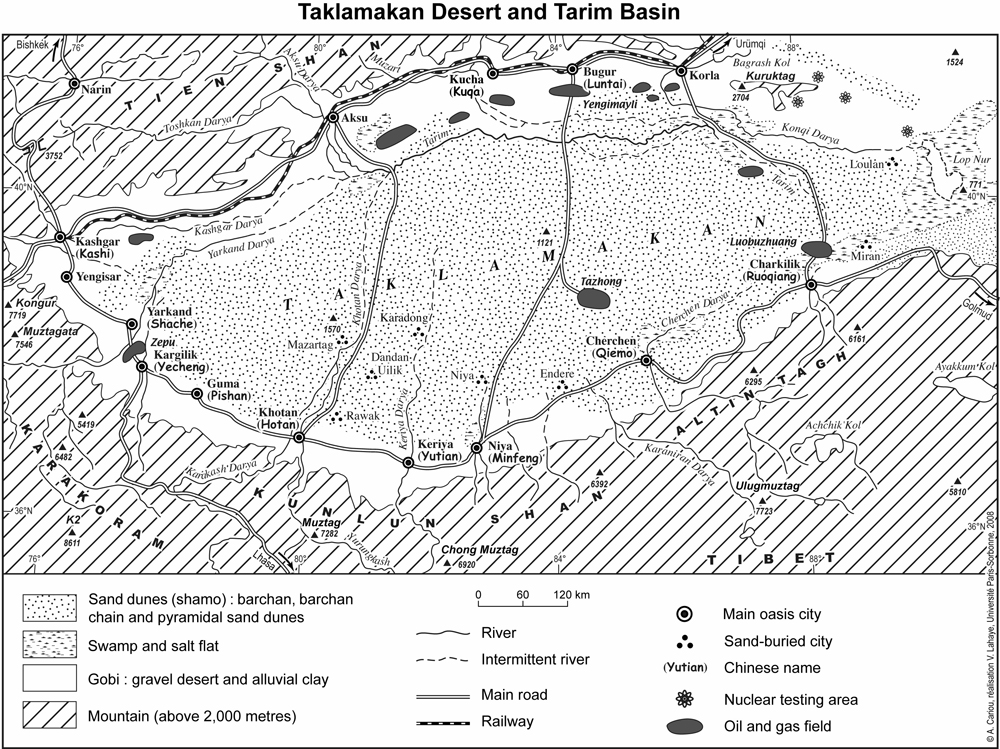
The Taklamakan stretches over 337,000 square kilometers in the centre of the Tarim basin. The vast depression runs nearly 1,200 km from west to east, and is 400 km wide from north to south. It forms an elliptical, semi-open basin in the Lop Nur marsh, at an altitude between 1,450 m in the west to 771 m in the east. The desert is open to the east through the Hexi Corridor, while on the other three sides its borders are high relief mountain ranges: the Kunlun to the south, the Karakorum and Pamir to the west, and Tien Shan to the north (Figure 1). It is composed of loose Quarternary alluvium sevral hundred metres thick and covered by up to 300 m of eolian sand (Petrov, 1975, p. 6). This topographic formation is the result of intracontinental subduction caused by the penetration of the Indian plate into the Asian plate (Tapponnier, 1986).
The Taklamakan is an interior desert, enclosed by high ranges and therefore isolated from the influences of the west wind of the general circulation and of the southerly monsoon. This Central Asian desert in the heartland of Eurasia, thousand of kilometers away from the ocean, endures an extreme dry continental climate. Rainfall does not exceed a 20 mm per year average in its central part, and a 50 mm average on the edges. Precipitation mostly occurs between May and August, with a high temporal concentration but great inter-annual variability. The Taklamakan is also a cold desert characterized by drastic temperature changes between winter and summer. Winter lasts six months, during which the Tarim basin is under the influence of high pressure whenever cold air masses drift from Siberia to the high Tibetan plateaus. This anticyclonic pattern is characterized by cold, though sunny, weather with an average mean temperature below freezing in January: -6° Celsius in the center of the desert and -8° Celsius on the edges. The lowest temperatures reach -24° and -28° Celsius, respectively (Ling, 1991a, p. 124). The rivers freeze, and sometimes a thin layer of snow covers the sand dunes. In the summer, the heat concentrates in the Tarim basin and the mean temperature in July is higher than 26° Celsius in the center of the desert and 24° Celsius on the edges. The highest maximum temperatures are 40° and 36° Celsius, respectively. Due to low pressure the atmospheric conditions are more unstable in warm summers than in cold winters. The cyclonic flow causes frequent winds, violent sand storms, and suspended dust.
The continental desert climate impacts the geographical landscape, and explains why the whole Taklamakan is a desert. Drifting sand dunes (Chin. shamo) cover 85 percent of the area. The continuous dune field shows different types of sandy landforms. In general, the sand dunes range in altitude between 20 and 100 m and are crescent-shaped, which are known as barchan. Usually, they form barchan chains, parallel to the prevailing wind direction. The concatenation of dunes leads to a system of longitudinal dunes mostly stretching from north to south. In the southern part of the Taklamakan, between Keriya and Cherchen, sand dunes are particularly high, and can reach a height of up to 140 m. Aeolian landforms become pyramidal because the wind is blowing in different directions (Ling, 1991b, p. 117). This eolian sand is the result of re-deposition of Quarternary alluvial and proluvial sediments from the depression and piedmont plains, witch vary in age and include material originating from Pleistocene, Holocene and Recent Deposits (Petrov, 1975, p. 6). The gravel desert (Chin. gobi) on Taklamakan’s periphery are vast alluvial fan deposits, composed of heterogenous detrital material, in the subsiding basin.
The endoreic (i.e. closed or inland) rivers which descend from the surrounding ranges create an elliptical string of oases along its rim, such as Aksu, Kasghar, Keriya, Khotan, Niya, and Cherchen. The most important stream is the Tarim river, swollen by the confluence of the Kashgar and Yarkand rivers in the west. Running from the Tien Shan mountains, the Aksu river is the main water supplier to the Tarim river, with a volume contribution up to 76 percent (Ren, p. 393). On the southern rim, several lesser streams such as the Khotan and the Keriya only flow in spring and early summer because they are fed by the melting snow and ice of the glaciers range. In the past, these rivers used to be connected to the Tarim river but nowadays they vanish in the sands of the Taklamakan. The Lop Nur lake in the eastern part of the desert is mostly fed by underground waters, and the extensive utilization of its tributaries for irrigation has gradually turned the lake into a vast flat salt depression. The tributaries flow into the desert so that the natural vegetation can survive along their banks. A typical plant community in natural desert areas of Central Asia (Turk. togkai; cf. Tian, p. 100) is dominated by reeds (phragmites) on the first terrace in the flood-plain, poplar (populus euphratica) woodlands on the second terrace, and mounds of withered shrubs of tamarix between moving sand dunes on the third terrace.
Thanks to this abundance of water and alluvial soil, sedentary agro-pastoral societies have lived in the Taklamakan desert since the first millennium BCE (Debaine-Francfort and Idriss). Along the elliptical borderline, between shifting sand dunes and gravel desert, a string of oases flourished between the 3rd century BCE and the 16th century CE, serving as a series of stopovers on the famous Silk Road. The Taklamakan was integrated into the essential trading network for the exchange of goods, languages, religions, and arts between China, India, Iran, the Arab lands, and Turkey. For centuries, many famous travelers, such as the Chinese envoy Zhang Quian (d. after 115 BCE), a famous Buddhist monk Xuanzang (d. 664 CE), or Marco Polo (1254-1323?), crossed this desert. The latter reported about the dangers of the Taklamakan, then called the Desert of Lop (Polo, pp. 138-41). Its brilliant past and accurate geographic information were first reported by the expeditions of the famous explorers Sven Hedin (1865-1952) and Aurel Stein (1862-1943). They described their discovery of lost cities, buried beneath the sands alongside abandoned riverbeds. The excavation of the sand-buried cities such as Dandan Uiliq, Niya, Endere, and Lou-lan, revealed the prosperity of the ancient multicultural desert settlements under Persian, Indian, Tokharian, Hellenistic, and Chinese influences (Boulnois, p. 81).
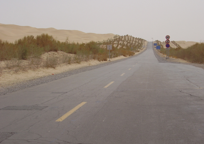
Nowadays the treasures of the Taklamakan are petroleum and natural gas deposits. The estimated reserves in the Tarim basin total 8 billion tons of oil and 10 trillion cubic meters of gas, and therefore China considers the Tarim basin of primary strategic importance. The recent exploitation of these oil and gas fields has caused a rapid economic expansion and urbanization which in turn are accompanied by geographic changes. To improve access to the Taklamakan’s natural resources two highways (Figure 2) across the desert were opened in 1995 and 2007, respectively, and a gas pipeline was built between the Taklamakan and Shanghai. Industrial parks of oil-field services and petrochemical enterprises were developed, especially in the geographical bow of Korla-Luntai-Aksu, along the northern border of the Taklamakan. At the same time, some wastelands in the Taklamakan were transformed into cotton and rice fields. The Xinjiang Production and Construction Corps, a paramilitary organization, has built a vast water network in order to irrigate hitherto unused lands. Since the completion of the Southern Xinjiang railway between Eastern China and Kashgar in 1999 a substantial number of Han Chinese have migrated to the small, traditionally Uyghur oasis. With the increase of human and industrial pressures and the improved transportation infrastructure, the Taklamakan is no longer the unexplored and mysterious desert, haunted by evil spirits who led astray travelers lagging behind their caravan, as described by Marco Polo.
Bibliography
Luce Boulnois, La route de la soie: Dieux, guerriers et marchands, enl. ed., Geneva, 2001; orig., Paris, 1963.
Corinne Debaine-Francfort and Abduressul Idriss, Keriya: Mémoires d’un fleuve – Archéologie et civilization des oasis de Taklamakan, Paris, 2001; exhibition catalogue.
Sven Hedin, Through Asia, tr. from the Swedish by J. T. Bealby, 2 vols., New York, 1899.
Sven Hedin et al., Scientific Results of a Journey in Central Asia 1899-1902, 8 vols., Stockholm, 1904-1907; 6 vols. of text and 2 vols. of atlas.
Peter Hopkirk, Foreign Devils on the Silk Road: The Search for the Lost Cities and Treasures of Chinese Central Asia, London, 1980.
George Kish, To the Heart of Asia: The Life of Sven Hedin, Ann Arbor, Mich., 1984.
Y. Ling, “Climatic Characteristics and their Changing Tendency in the Taklimakan Desert,” in Reports on the “1986 Sino-German Kunlun-Shan Taklimakan Expedition,” ed. D. Jäkel and Z. Zhenda, Die Erde, Special Issue 6, 1991a, pp. 122-32.
Idem, “Flow Field Characteristics and their Relationship to the Intensity of Drifting Sand Activity in the Taklimakan Desert,” in Reports on the “1986 Sino-German Kunlun-Shan Taklimakan Expedition,” ed. D. Jäkel and Z. Zhenda, Die Erde, Special Issue 6, 1991b, pp. 113-21.
Mikhail P. Petrov, Pustyni tsentral’noĭ Azii, 2 vols., Moscow, 1966-67, esp. II, pp. 141-234.
Idem, Deserts of the World, New York, Toronto, Jerusalem., 1975.
Marco Polo, Le devisement du monde: Le livre des merveilles, ed. A. C. Moule and P. Pelliot, tr. into French by L. Hambis, with introduction and notes by St. Yerasimos and maps by P. Simonet, Paris, 1996; orig., 2 vols., Paris, 1980.
Mei-O Ren et al. , Géographie physique de la Chine, Beijing, 1989.
Aurel Stein, Sand-Buried Ruins of Khotan: Personal Narrative of a Journey of Archaeological and Geographical Exploration in Chinese Turkestan, London, 1903.
Idem, Ruins of Desert Cathay: Personal Narrative of Explorations in Central Asia and Westernmost China, London, 1912.
Idem, On Ancient Central-Asian Tracks: Brief Narrative of Three Expeditions in Innermost Asia and North-Western China, London, 1933.
P. Tapponnier at al., “On the Mechanics of the Collision between India and Asia,” in Collision Tectonics, ed. M. P Coward and Alison C. Ries, Geological Society of London – Special Publication 19, 1986, pp. 115-57.
Y. Tian, “Tokai on the delta at lower reach of the Keriya River,” in Reports on the “1986 Sino-German Kunlun-Shan Taklimakan Expedition,” ed. D. Jäkel and Z. Zhenda, Die Erde, Special Issue 6, 1991, pp. 99-112.
Xinjiang Bureau of Statistics, Xinjiang Tongji Nianjian 2001 (Xinjiang Statistical Yearbook), Beijing, 2002.