


SORḴA (locally: Sur), township and sub-province in Semnān Province.
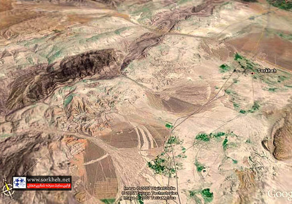
Sorḵa is situated 20 km southwest of Semnān and 12 km northwest of Lāsgerd (lat 35o28′ N, long 53°13′ E, elev 1,100 m above sea level). Sorḵa and its immediate hamlets rest on a series of alluvial cones formed by clefts cut through rocky chains to their north (Bouzari et al.) that constitute the southernmost edge of the Central Alborz. The toponym “Sorḵa” (“the red one”) seems to derive from the colored marls and clays of the Upper Red formation (Purkermān et al.) within the soil composition of these slopes. On the south Sorḵa faces downslope to the Great Desert, with poor vegetation akin to that of the kavir (see desert) (Figure 1).
Among the 10th-century geographers only Ebn Rosta (p. 169), in 902, mentions “S.ra” (i.e., Sura, Sorḵa’s endonym even in that day), as a village between Raʾs-al-Kalb and Semnān. Four centuries later, Ḥamdallāh Mostawfi (p. 173; tr., p. 168) says the same: Deyh Sorḵ is located six farsaḵs distance to Raʾs-al-Kalb and four farsaḵs to Semnān. There is no other mention of Sorḵa in major medieval sources—an indication that it would be far less important than its immediate neighbors. Indeed Sorḵa occupied only an intermediate position between Semnān and Raʿs-al-Kalb, two major caravan stations equipped with caravansaries, which used to be built at intervals of thirty to forty kilometers along the Great Khorasan Road. Raʿs-al-Kalb is now replaced by Lāsgerd, even if not on the exact same site.
Under Safavid rule, the inhabitants of Sorḵa were distinguished for having resisted the coercive policy of conversion to Shiʿism. According to the historian Mollā Jalāl Monajjem, under the events of 1008, in the month of Ṣafar (September 1599) Shah ʿAbbās I imposed a severe retribution on the Sunni population of Sorḵa by crippling their mullahs and fining them three hundred tomans (Monajjem, p. 193). To the same effect, a royal inscription of Shah ʿAbbās I, reinstated by Shah Solṭān-Ḥoseyn in Semnān’s congregational mosque, decrees a tax relief by one-fifth to the people of Semnān province for their espousal of the Shiʿi faith, but with exclusion of Sorḵa (velāyat-e Semnān savā-ye qarya-ye Sorḵa; Ḥaqiqat, pp. 276-77). The long belated conversion of the Sorḵa’is is supported by a local joke: a Semnāni peasant, while planting a pomegranate tree, was cursing the second caliph, ignorant of the Sunni convictions of his Sorḵaʾi master; the latter, having overheard him, said dār dekār, nār bexor, magar Omar te mār bekarde? “Plant the tree and eat the pomegranates; did ʿOmar do it with your mother?” (Ḥaqiqat, p. 278). It is unknown when Sorḵa finally surrendered to the new faith, but its resilience reveals itself also in the preservation of its original language, called Sorḵa’i (q.v.), up to this date.
Sorḵa has seen continual growth in size and population since the late Qajars. Houtum-Schindler described it as a large village of 300 houses, with a rundown caravansary, a mosque, a large cistern, and extensive gardens, which was taxed 1,500 tomans by the government (apud Adamec, I, p. 628). Under Reza Shah, Sorḵa was a boluk of Semnān with 1,400 households, inhabited by 7,000 individuals (Keyhān, II, p. 210). In the 1940s Sorḵa was a rural district (dehestān) with eight settlements (ābādi) (including Lāsgerd and Biābānak) and a total of 7,200 souls. The economy was based on cultivation of grains, cotton, tobacco, and melons and production of textile and carpets (Razmārā, III, p. 152). By the turn of the 20th century, olive and pistachio horticulture and industrial poultry farming was introduced to the district. Salt and gypsum and lime mines are exploited there, and plastic ware is produced in many small shops. In the hinterland an “industrial town” (šahrak-e sanʿati) is laid out, which, although sparsely occupied, is hoped to invite manufacturing—an achievable goal thanks to Sorḵa’s position on the Tehran-Mašhad railway. According to the decennial census of 2006, the town and district were home to 9,062 and 14,194 inhabitants, respectively (Markaz-e Āmār-e Irān).
Sorḵa was promoted to sub-province (šahrestān) on 28 January 2013. It has two districts (baḵš): Markazi, centered at Sorḵa, with Lāsgerd and Biābānak as its rural districts (dehestāns), and Hafdar, centered at Moʾmenābād, with Moʾmenābād and Hafdar (Aftar) as its rural districts. The promotion of Sorḵa to sub-provincial capital was justified by its “natural geography, harnessing of economic resources, and propagation of the culture of jihad and martyrdom” (ILNA); the third point alludes to long overdue compensation for the significant number of Sorḵaʾi casualties in the Iran-Iraq War. Nevertheless, this administrative reconfiguration is rooted in the local aspiration to increase Sorḵa’s state-allocated budget share and augmentation of local authority (see Chehabi for a comparable study on Ardabil). This ambition probably would not have been realized as easily as it was without the rise of Hassan Rouhani, who was born and raised in Sorḵa (as Ḥasan Fereydun) and has climbed the ladder of political authority, winning election as president of Iran in June 2013.
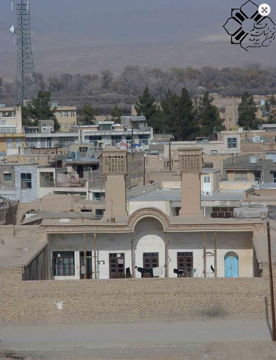
The urban morphology of Sorḵa is largely modern, with little architecture left from the past. The oldest edifice is probably the Čehel Sotun Mosque that has seen numerous renovations. At least one old residence still stands: that of Ḥāj Ḥešmat Lašgar, with lofty wind towers (bādgirs) flanking its spacious southward-looking ayvān (Figure 2); this house typifies a regional landlord dwelling (ḵāna-ye arbābi) from the Qajar period. Another attractive landmark of Sorḵa is its old cistern beneath a conic dome.
Bibliography
L. W. Adamec, Historical Gazetteer of Iran, 4 vols., Graz, 1976-81.
S. Bouzari, A. Kononb, M. Koprianiukc, A. A. Julapour, “Thin-skinned tectonics in the Central Basin of the Iranian Plateau in the Semnan area, Central Iran,” Journal of Asian Earth Sciences 62, 2013, pp. 269-81.
H. E. Chehabi, “Ardabil Becomes a Province: Center-periphery relations in Iran,” International Journal of Middle East Studies 29, 1997, pp. 235-53.
Ebn Rosta, Ketāb Aʿlāq al-nafisa, ed. M. J. De Goeje, BGA, Leiden, 1892
ʿA. Ḥaqiqat (Rafiʿ), Tāriḵ-e Qumes, Tehran, 1983.
ILNA (Iranian Labor News Agency), “Sorḵa ba-ṣurat-e rasmi ba šahrestān erteqāʾ yāft,” 27 February 2013, at http://ilna.ir/news/news.cfm?id=50055 (accessed 17 October 2013).
M. Keyhān, Joḡrāfiā-ye mofaṣṣal-e Irān, 3 vols., Tehran, 1931-32.
Markaz-e Āmār-e Irān (Sāzmān-e Barnāma o Budje), Village Gazetteer/Farhang-e ābādihā-ye kešvar XVII. Farmāndāri-e-koll-e Semnān, Tehran, 1970.
Idem, Saršomāri-e ʿomumi-e nofus o maskan, decennial.
Mirzā Ebrāhim, Safarnāma-ye Astarābād o Māzandarān o Gilān, ed. M. Golzāri, Tehran, 1976.
Jalāl-al-Din Monajjem Yazdi, Tāriḵ-e ʿAbbāsi, ed. Sayfallāh Vahidniā, Tehran, 1987.
Ḥamdallāh Mostawfi Qazvini, Nozhat al-Qolub, ed. and tr. Guy Le Strange, as The Geographical Part of the Nozhat al-Qolub, 2 vols., Leiden, 1915-19.
M. Purkermān et al., “Šenāsā’i-e ʿavāmel-e šimiāʾi-e taʾṯirgoẕār bar rúye moqāvemat-e ḵāk … Moṭāleʿa-ye mārnhā-ye ḥowza-ye Sorḵa,” Faṣlnāma-ye ʿolum o mohandesi-e ābḵizdāri 5, ser. no. 16, 2001, pp. 16-25.
Ḥ.-ʿA. Razmārā, ed., Farhang-e joḡrāfiāʾi-e Irān, 10 vols., Tehran, 1950.