

KULĀB, city, district, and former province of Tajikistan (also Kōlāb, Kolāb[a]; Tajik Kūlob, Russian Kulyab; apparently köl-āb “lake-water”).
The district of Kulāb is naturally marked out by the river Panj (upper Oxus) and the Hażrat-e Šāh range in the east, offshoots of Tajikistan’s central mountains in the north, the Tēraklitāḡ and Qarātāḡ ranges in the west, and again the Panj in the south, to which flows southward the Qezelsu (Sorḵāb), the main river of the region, with the tributaries Tāher-su, Yaḵsu (Āqsu), and Kulāb-daryā (Aḵšu). The precipitation is much higher in the northern piedmonts (60-80 cm) than in the southern fertile plain of Farḵār-Čubak (20-40 cm).
Kulāb forms the greater part of the medieval province of Ḵottal(ān)/Ḵatlān, whose seat Holbok has been excavated near the village of Qorbān Šahid, south of the town of Kulāb. Other towns reported by geographers were Halāvard, Monk, Andijārāḡ, Fārḡar, and Tamliāt; the last probably corresponds to modern Baljovān/Boljovān (cf. Le Strange, Lands, p. 438). Historically the region was often linked with Qobādiān and Čaḡāniān, topographically similar territories on the west, and with mountainous Ḥeṣār, Qarātegin, and Darvāz on the northwest, north, and east, and to a lesser extent with the territories linked with Balḵ across the Oxus. Throughout its history, Ḵottal/Kulāb remained a vassal of successive empires, but often with substantial degrees of autonomy due to its relative isolation.
The first mention of Kulāb appears to be by Ebn al-Aṯir (1160-1233; VIII, p. 97), who refers to the fortress (qalʿa) of K[o]lāb(a) in his account of the Mongol invasion of Transoxiana (cf. Barthold, Turkestan, p. 419; idem, Sochineniya I, p. 487). The next mention of the qalʿa occurs much later, in 963/1555, by the Turkish admiral Sayyed ʿAli Raʾis (tr., pp. 66-67). In his journey from Badaḵšān, on the south of the Oxus, to Transoxiana, the traveling admiral could not help choosing the difficult, roundabout route of Ḵatlān because the main road via Termez had been made unsafe by a revolt in Kondoz and Qobādiān. Sayyed ʿAli Raʾis states that in Ḵatlān he approached Dalli, where he made a pilgrimage to the grave of the celebrated Sufi leader Mir Sayyed ʿAli Hamadāni, whence he went to Kulāba to meet with the ruler of Ḵatlān, Jahāngir ʿAli Khan, who had married to a sister of Solaymān Shah, the ruler of Badaḵšān (ibid). The status of Kulāb as the seat (dār al-molk) of Ḵatlān/Ḵottalān had become permanent after the Uzbek invasion of 992/1584, as stated first in 1002/1594 by the historian Amin Aḥmad Rāzi (II, p. 95).
The locality “Dalli,” mentioned by the Turkish admiral, has been identified with the village Dili (or Deli; renamed Emām ʿAli in the post-Soviet era) near modern Kulāb city, where the shrine of Mir Sayyed ʿAli Hamadāni (1314-84) is now located. This presupposes that the shrine was relocated, at least nominally, from Deli to Kulāb. A recent study proposes the date of the relocation sometime between 1584 and 1594 CE, i.e., two centuries after Mir Sayyed ʿAli Hamadāni’s death (Ḡoibov, pp. 109, 137-44). The relocation of the shrine must have contributed to the importance of the town. Subsequently, Kulāb as the name of a town was gradually extended to designate the entire province. Already in the early 17th century the name Kulāb was current for the province, as noted in the Baḥr al-asrār of Maḥmud b. Amir Wali, historian of the court of Balḵ (MS fol. 143b; tr., p. 28). The old name, Ḵottalān or Ḵatlān, however, continued to be used sporadically as a historical reminiscence as late as the early 20th century (for instance, Koškaki, p. 10; Baljovāni, p. 32).
Modern history. In modern times, the region was often divided administratively into Kulāb proper in the southeast and Baljovān in the northwest. Due to the importance of Kulāb as a trading point on the route between Ḥeṣār and Afghanistan, the surrounding Uzbek states competed to control it. The beginning of the Uzbek rule is marked by the invasion of the Shaibanid ʿAbd-Allāh Khan, who seized and plundered the Kulāb’s qalʿa in 992/1584; he commissioned his cousin Uzbēk-solṭān to demolish it and build a new fortress in Halvāy, one farsaḵ away (Ḥāfez Tanïš, apud Ḡoibov, pp. 109-12), perhaps in the present location of Kulāb city.
During the 17th century, the province was given as a fief (eqtāʿ) to various princes, who were subordinate to the Ashtarkhanids (Janids) of Balḵ (Eskandar Beg, I, p. 607; tr. Savory, II, p. 797). Naḏr Moḥammad, the ruler of Balḵ, appointed his ambitious eleven-year-old son ʿAbd-al-ʿAziz (r. 1645-81) the governor of Kulāb in 1035/1625-26. The latter immediately responded to recent raids by the Qïrqïz tribes by storming their camping grounds near Kāšḡar and compelled them to sue for peace. Consequently, Kulāb was no longer raided, and by 1634 it had prospered, producing much grain, and was able to pay its taxes in gold (Maḥmud b. Wali, apud Briton, pp. 172-73). In 1040/1630-31 ʿAbd-al-ʿAziz was replaced by his younger brother Ḵosrow, who ruled Kulāb for a few years (idem, p. 186) and in turn was replaced by yet another brother, Baharām (Moḥammad Yusof, tr., p. 95).
With the decline of the Ashtarkhanids, the predominant role in Kulāb seems to have been gradually acquired by the Uzbek tribe of Lakai/Laqay, who penetrated the region from the northwest (Karmysheva, 1976, pp. 231 ff.). On the other hand, soon after the Uzbeks of Qaṭaḡan established themselves in Qondoz (Kondōz), their leader Bēg-Morād Khan (d. 1110/1698-99) expanded his domain northward to Kulāb, over which he appointed his son as the governor (Koškaki, pp. 12-15; tr. pp. 7-10). The Uzbeks’ authority ended in 1164/1751, when the local rulers south of the Oxus submitted to Aḥmad Shah Dorrāni, the founder of Afghanistan. In 1166/1752-53, recurring raids of the Kulābis to the south were repelled with heavy casualties inflicted upon them (Badaḵši, pp. 39-41). For the rest of the century Kulāb passed under the control of the expanding Ḥeṣār (Yusupov 1975, pp. 17-18).
For most of the 19th century Kulāb and its northern neighbors Qarātegin and Darvāz formed a buffer zone among the powerful states of Bukhara, Ḵōqand, and Afghanistan. Baljovān minted its own coins in the early years of the century (EST, s.v. “Baljuvon”). The region’s independence, however, was briefly interrupted in the 1830s when the Uzbek rulers of Qondoz and Kōqand laid claim to the region, and their battle for Kulāb resulted in the destruction of the town (1832). In the same year, Morād Bek, the ruler of Qondoz, made several futile attempts to annex Baljovān with its antimony mines, but the inhabitants of the town, from the Uzbek tribes of Lakai and Qaṭaḡan, offered a stubborn resistance under the leadership of Kata Khan, and could even raid Kurgan Tepe, which had already come into the orbit of Qondoz (Yusupov, 1975, pp. 18-20). Sara Bek Atalïq (or Sari Khan), the new ruler of Kulāb and Baljovān (1856-70), rebuilt the town of Kulāb and expanded his domain westward to the valleys of the Vaḵš and Kāfarnehān rivers (Yusupov, 1964, p. 32; idem, 1975, p. 19).
In 1287/1870, the Mangït ruler of Bukhara Amir Moẓaffar-al-Din expanded his domain eastward with the help of the Russians who had reduced Bukhara to vassalage only two years before. Consequently, the governorships (bekdoms) of Kulāb and Baljovān were made subordinate to the super-province of Ḥeṣār, which ruled also over Kurgan Tepe, Qobādiān, Darvāz, and Qarātegin (Gafurov, II, pp. 175 ff.; cf. Badaḵši, pp. 86-92). Nevertheless, the bek of Kulāb, Ḵodāynaẓar Atalïq, who had secured the new provinces for the amir (Badaḵši, p. 86), enjoyed vast authority and was virtually autonomous (Barthold, Sochineniya II/1, p. 431; Yusupov, 1975, p. 22).
Reports by Russian travelers and officials of the late 19th and early 20th centuries offer for the first time some detailed facts about the region. In 1886, the Russian traveler Pokatilo described Baljovan as having 15 rural districts (amlāks) and 20,000 families totaling 60,000 souls, mostly Tajiks. (EST, s.v. “Baljuvon”). Just before Soviet rule, the Baljovān bekdom consisted of Baljovān, Kangort, Ḵavāleng, and Sar-e Ḵāsār (Varygin; cf. Baljovāni, p. 32; Amonov, 1963b, pp. 18-19). The town of Kulāb consisted of 17 quarters (gozars) with a mosque in each and several madrasas (Kolpakov; see also Arandarenko, pp. 428-30; Entsiklopedicheskiĭ slovor’ XVII, St. Petersburg, 1896, p. 9; Semënov, 1902a, 1902b; Lipskiĭ, pp. 586-88; Rozhevits, pp. 620-21; Masal’skiĭ, pp. 737, 739).
Beginning in 1885 a rebellion broke out and spread from Baljovān to Mo’menābād (northeast of the town of Kulāb; renamed “Leningrad” in the 1970s), when, owing to a good harvest, the tax collectors demanded payment not only of current tax but also of arrears. The uprising was eventually crushed by troops sent from Bukhara; and its leader, Wāseʿ, was captured and brought to Bukhara, where he was put to death (Gafurov, II, pp. 215-17). The incident was later dramatized in the first Tajik opera Šōreš-e Wāseʿ (see FEṬRAT BOḴĀRI) and further embellished in the Soviet literature (e.g., Litvinskiĭ et al., pp. 106-07, 176;see also below).
The advancing Red army forced the last bek of Baljovān, Jahāngir Khan, to flee to Afghanistan in 1921. Kulāb, however, remained the last stronghold of the Basmachi (q.v.) resistance; Anwar Pasha, who had fled from Ḥeṣār, joined Dawlatmand Bi, a local warlord, to reorganize the insurgents, relying on the support of the local Lakai tribes, but was finally killed in the mountains of Kulāb in August 1922, and the insurgency was totally suppressed in a few years (Baljovāni, pp. 96-99; Istoriya III/1, pp. 164 ff.; Gafurov and Prokhorov, p. 181).
In Tajikistan. Within Soviet Tajikistan, Kulāb gained the status of province (welāyat, oblast) in 1939-55, and again in 1973-92, after which it was unified with its western neighbor Qōrḡāntēppa/Kurgan Tepe into the new province of Ḵatlān. The area of the province of Kulāb was 12,000 km2; its population, more than 400,000 according to the 1979 census, doubled by the turn of the century (Abdulaev et al., p. 112). Its main produce was cotton and cereals, with gardening and sericulture prevailing in the upper slopes of the hills which also offer rich pastures to herders. The rural life of the province was organized into large collective farms (kolkhozi, lately renamed jamāʿathā; see ECONOMY xii.). Everyday life in a kolkhoz in the rural district of Wāseʿ is portrayed by the Tajik novelist Jalāl Ekrāmi in Ḵatlān (Jalol Ikromi, Ḵatlon, Dushanbe, 1985). Cotton-growing farms began to expand in the late 1940s, when a large number of the dwellers in mountain villages were forced to migrate to the southern plains of the province or to the valley of Vaḵš on the west (Amonov, 1963b, pp. 21-22; EST III, p. 609; Sattorov, passim; Kurbanova, passim; Ḡoibov, pp. 139-40). Consequently, many settlements disappeared from the maps, which reveal also major administrative rearrangement of the province caused by the demographic redistribution. Baljovān, which once rivaled Kulāb for the seat of the province, shrank to an undistinguished village.
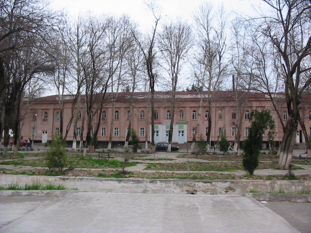
The city of Kulāb, the administrative center of the former province, stands 580 m above sea level in the valley of the Yaḵsu, 200 km southeast of Dushanbe, to which it is connected by rail via Qōrḡānteppa. The dead-end position of Kulāb has been overcome only recently by extending roads northeastward to the Pamirs. The population of the town doubled in the period 1926-39 to 8,400, and jumped to 56,500 by 1980, making the town the third most populous in the republic. Its modern industry, however, remained modest: a cotton ginning plant and a vegetable oil mill were the most notable facilities. Its educational institutions included teacher-training (Figure 1) and medical colleges (Goroda, pp 35-38; EST III, p. 561).
Following the independence of Tajikistan, Kulāb played a major role in the political affairs of the republic. Due to its relative underdevelopment, the province nurtured conservative forces who despised the developments which were taking place in the capital. The civil war of 1992 began with fighting among opposing groups in the streets of Kulāb, and it spread to the rest of the country when Sangak Safarov, the local warlord who had blockaded the province, led his armed men of the Popular Front westward to Qōrḡānteppa and then to Dushanbe. The emerging government was almost entirely made up of former officials from Kulāb and Ḵojand, allied victors of the irredentist civil war (Brown; Russia and Eurasia, p. 328).
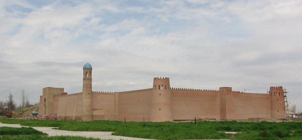
Monuments. Archeological sites of Kulāb are rather limited. In addition to Holbok (Figure 3) (see above), excavations include communal houses form the late Neolithic in Bolyān mountain in Danḡara and a Greco-Bactrian site in Saksanāḵōr on the northern bank of the Panj (Litvinskiĭ and Mukhitdinov, 1969).
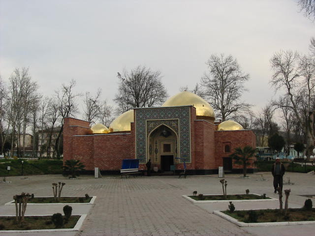
A major surviving edifice is the mausoleum of Amir Sayyed Hamadāni (1314-85), which attracts many pilgrims to the city of Kulāb. It is centered on a richly carved three-portal structure consisting of a domed hall and burial vault from the Shaibanid era, to which several domed chambers were added later (Figure 2). From the same period or even earlier survives Yār Moḥammad Wali’s tomb in the village of Boḵārak and the mosque and mausoleum of Šāh-e Ḵāmōš in Langar-kalān. In the latter village stands also the two-centuries-old shrine of Dāmollā Ekrām, but it is poorly maintained (Borjian, 1998; Oriyon, 1992; see also Tajikistan, monuments).
Ethnography and culture. The region is Persian-speaking with a distinct dialect (see below). The Turkic elements seem to have been largely absorbed into the Iranian population, but they left behind a rich heritage of folklore (see below), toponyms, and perhaps traces of physical appearance. While the medieval sources mention the Kumiji and Kanjina tribes as associated with Ḵottal (Barthold, Turkestan 4, pp. 297, 301; Ḥodud al-ʿĀlam, tr. Minorsky, p. 120), in modern times the nomadic Uzbek tribes of Lakai and Qaṭaḡan established themselves in the province (see above). Although some of the Lakai fled to Afghanistan during the Basmachi unrest in 1924, there were still about 25,000 Lakais in the republic, mainly in Ḥeṣār and Baljovān. In the course of collectivization, many Lakais, along with their Tajik and other Uzbek neighbors, were resettled along the lower Qezelsu and Yaḵsu, with pockets still remaining in highlands (mainly in Danḡara area; for their folklore, see Mirkamolov). The bulk of the Uzbek population, however, is distributed in the southern lowlands (Karmysheva, 1954; idem, 1976, pp. 88-89; Atlas, pp. 120-21).
The celebrated folklore of the refuge high mountain valleys of Kulāb was well intact until the dispersal of the communities due to resettlement polices. Attempts to document them began with three expeditions from the Tajik Science Academy in the 1930s aiming at folk data on Wāseʿ’s uprising (see above); the collected material were published extensively (e.g., Buzurgzoda and Jalilov; Boldirev; for a survey, see Amonov, 1963b, pp. 4-6). Rajab Amonov published another set of early collections of oral literature (Amonov, ed., 1963a) with extensive ethnographic material (idem, 1963b). The most unique of Kulāb’s oral traditions, however, are Tajik versions of the epic Gōrōḡli (or Gōr-ḡōli), which survived mainly in the far northern district of Sar-e Ḵāsār, where the Tajik inhabitants acquired the tradition from Uzbek herders who would summer in the region (Amonov, 1963b, pp. 74-119). Accounts of three Kulābi minstrels appeared under the main title Gūrūḡlī (Stalinobod and Leningrad, 1941; Dushanbe, 1962-63; Dushanbe, 1976).
Kulāb was known for its handicrafts such as woodcarving, goldsmith, leatherwork, pottery, embroidery (Ivanov, p. 73), and traditional female dresses (see CLOTHING xv). Saddle-makers of Kulāb inherited their craft from medieval times, when Ḵottalān was famed for horse breeding.
A primary source for the detailed study of social and cultural life of Kulāb is the newspaper Haqiqati Kūlob “Truth of Kulāb,” published since 1932. As a result of administrative revisions, its coverage shifted among the town, district, and province of Kulāb. During 1963-66 it was renamed, temporarily, Hayoti qišloq “Rural life.” From 1976 it covered the entire province under the new title Bo rohi Lenin “Along the path of Lenin” and circulated thrice weekly in 6,100 copies. The Russian edition of the paper was Kulyabskaya Pravda. Other local newspapers were Kommunisti Baljuvon (1938-53) and Kommunisti Mūʾminobod (1937-58), each appeared twice weekly.
Bibliography
Kamoludin Abdullaev and Shahram Akbarzadeh, Historical Dictionary of Tajikistan, Lanham, Md., 2002.
Amin Aḥmad Rāzi, Haft eqlim, ed. Jawād Fāżel, 2 vols., Tehran, n.d.
Rajab Amonov, ed., Èjodiyoti dahanakii aholii Kūlob (Oral literature of Kulāb), 2nd ed., Dushanbe, 1963a.
Idem, Ocherki èjodiyoti dahanakii Kūlob dar asosi materialhoi fol’klori Sari Ḵosor (Sketch of the oral literature of Kulāb based on the folklore materials from Sar-e Ḵāsār), Dushanbe, 1963b.
G. A. Arandarenko, Dosugi v Turkestane. 1874-1889, St. Petersburg, 1889.
Atlas Tadzhikskoĭ SSR, Dushanbe and Moscow, 1968.
Mirzā Sang Moḥammad Badaḵši, Tāriḵ-e Badaḵšān, ed. Manučehr Sotuda, Tehran, 1988.
Moḥammad ʿAli b. Moḥammad Sayyed Baljovāni, Tāriḵ-e nāfeʿi, ed. Aḥrār Moḵtārōf, Dushanbe, 1994.
W. Barthold (V. V. Bartol’d), Sochineniya, Moscow, 1963-77.
Idem. Turkestan Down to the Mongol Invasion, 4th ed., London, 1977.
A. N. Boldirev, ed., Namunaji folklori toçik (Specimen of Tajik folklore), Dushanbe and Leningrad, 1938.
H. Borjiān, “Āṯār-e meʿmāri-e Tājikestān (Historical monuments of Tajikistan),” Irānšenāḵt, ser. no. 9, 1998, pp. 134-79.
Bess A. Brown, “The Civil War in Tajikistan, 1992-1993,” in Mohammad-Reza Djalili, Frédéric Grare, and Shirin Akiner, Tajikistan: The Trials of Independence, New York, 1997, pp. 86-96.
Audrey Burton, The Bukharans: A Dynastic, Diplomatic and Commercial History: 1550-1702, Richmond, 1997.
L. Buzurgzoda and R. Jalilov, In’ikosi šūriši Vose’ dar fol’klor (Reflection of Wāseʿ uprising in folklore), Dushanbe and Leningrad, 1941.
ʿEzz-al-Din Ebn al-Aṯir, al-Kāmel fi’l-taʾriḵ, ed. C. J. Tornberg, 12 vols., Leiden, 1851-76; reprint Beirut, 1965.
EST = Èntsiklopediyai sovetii tojik, 8 vols., Dushanbe, 1976-86.
T. I. Fyodorova, Šahrhoi Tojikiston (Cities of Tajikistan), Dushanbe, 1972.
Bobojon Gafurov, Tojikon, tr. from Russian by Ahror Muḵtorov, 2 vols., Dushanbe, 1983-85, repr. 1998.
B. Gafurov and N. Prokhorov, Tadzhikskiĭ narod v bor’be za svabodu i nezavisimost’ svoeĭ rodiny (Tajik people in the struggle for freedom and independence of their homeland), Dushanbe, 1944.
Ḡolib Ḡoibov, Šahri Kūlob dar asri XVI: tibqi ma’lumoti Hofizi Taniš dar “Šarafnomai šohī” (Kulāb city in the 16th century: based on materials in Ḥāfeẓ Tanïš’s Šarafnāma-ye šāhi [i.e., ʿAbdollāhnāma]), Dushanbe, 1998.
Goroda Tadzhikistana: ukazatel’ literatury (Cities of Tajikistan: a guide to the literature), Dushanbe, 1967.
Bukhodor Iskandarovich Iskandarov, Iz istorii Bukharskogo emirata: Vostochnaya Bukhara i Zapadnyi Pamir v kontse XIX veka (From the history of Bukharan emirate: Eastern Bukhara and western Pamir at the end of the 19th century), Moscow, 1958.
Idem, Vostochnaya Bukhara i Pamir vo vtoroĭ polovine XIX v. (East Bukhara and the Pamirs in the second half of 19th century), 2 vols., Dushanbe, 1962-63.
Istoriya tadzhikskogo naroda (A history of the Tajik people), 3 vols., Moscow, 1963-65.
P. Ivanov, K istorii razvitiya gornogo promysla v Sredneĭ Azii (Towards the history of the development of mountain industry in Central Asia), Leningrad, 1932.
Bel’kis Khalilovna Karmysheva, Uzbeki-lokayty Yuzhnogo Tadzhikistana (The Uzbek-Lakais of southern Tajikistan), Trudy Instituta istorii, arkheologii i ètnografii AN Tadzhikskoĭ SSR, XXVII, Stalinabad, 1954.
Idem. Ocherki ètnicheskoĭ istorii yuzhnykh raĭonov Tadzhikistana i Uzbekistana (Sketch of the ethnic history of southern provinces of Tajikistan and Uzbekistan), Moscow, 1976.
A. P. Kolpakov, “Nekotorye svedeniya o kvartalakh dorevolyutsionnogo g. Kulyaba,” Izvestiya otdeleniya obshchestvennykh nauk AN Tadzhikskoĭ SSR V, Stalinabad, 1954, pp. 73-82.
Borhān-al-Din Koškaki, Rāhnemā-ye Qaṭḡan o Badaḵšān, Kabul, 1302 Š./1924; French tr. by Marguerite Reut, as Qatghan et Badakhshān, Paris, 1979.
Kulyab: drevnost’ i sovremennost’. Sbornik statey, posvy’aschennykh 3000-letiyu Kulyaba (Kulāb: Antiquity and modernity. Collection of articles dedicated to 3,000th year), Dushanbe, 2006.
Sh. I. Kurbanova, Pereselenie: kak eto bylo (Resettlement: How it was), Dushanbe, 1993.
V. I. Lipskiĭ, Gornaya Bukhara. Rezul’taty trekhletnikh puteshestviĭ v Srednyuyu Aziyu v 1896, 1897, 1899 godu III, Saint Petersburg, 1905.
B. A. Litvinskiĭ and Kh. Mukhitdinov, “Antichnoe gorodnishche Saksanokhur,” Sovetskaya Arkheologiya, 1969, no. 1, pp. 160-78.
B. A. Litvinskiĭ, A. Mukhtorov, B. A. Kozachkovkiĭ, and I. O. Obidov, Ta’riḵi RSS Tojikiston. baroi sinfhoi 9-11, 6th ed., Dushanbe, 1964.
Vladimir Ivanovich Masal’skiĭ, Rossiya: Polnoe geograficheskoe opisanie nashego otechestva XIX. Turkestanskiĭ kraĭ (Russia: a complete geographical description of our motherland XIX. region of Turkestan), Saint Petersburg, 1913.
Maḥmud b. Amir Wali, Baḥr al-asrār fi manāqeb al-aḵyār, MS. 1375, Institut vostokovedeniya AN Uzbekskoĭ SSR; passages on geography are edited and translated by B. A. Akhmedova as More taĭn otnositel’no doblesteĭ blagorodnykh (geografiya), Tashkent, 1977.
M. Mirkamolov, Doir ba fol’klori laqay—Ūzbekoni rayonhoi janubii Tojikiston (Concerning Lakai folklore: Uzbeks of southern districts of Tajikistan), Dushanbe, 1971.
Moḥammadyār b. ʿArab Qaṭḡān, Mosaḵḵer al-belād (Tāriḵ-e Šaybāniān), ed. Nādera Jalāli, Tehran, 2006.
Moḥammad Yusof b. Ḵvāja Baqā Monši, Taʾriḵ-e moqim-ḵāni, tr. A. A. Semënov as Mukim-khanskaya istoriya, Tashkent, 1956.
H. Oriyon, “Sayri Ḵatlon-zamin,” Merosi niyogon 1, 1992, pp. 7-9.
R. Yu. Rozhevits, “Poezdka v Yuzhnuyu i Srednyuyu Bukharu v 1906 g.,” Izvestiya Russkogo geograficheskogo obshchestva 44, no. 9, Saint Petersburg, 1908, pp. 593-656.
Russia and Eurasia: Facts & Figures Annual, vol. 26, part 2, Gulf Breeze, Fla., 2000.
Abdukakhkhor Sattarov, Sovershenstvovanie sel’skogo rasseleniya v Yuzhnom Tadzhikistane (Accomplishing village settlements in southern Tajikistan), Dushanbe, 1989.
Sayyed ʿAli Raʾis Kātebi (Seydî Ali Reis), Merʾāt al-mamālektr. from Turkish to English by Ármin Vámbéry (Vambéry), The travels and adventures of the Turkish Admiral Sidi Ali Reïs in India, Afghanistan, Central Asia, and Persia, during the years 1553-1556, London, 1899; reprinted Lahore, 1975.
A. A. Semënov, “Po granitsam’ Bukhary i Afganistana: Putevye ocherki 1898 g., I. Kulyab’ (On the border of Bukhara and Afghanistan: travel notes of 1898. Part I. Kulāb),” Istoricheskiĭ vestnik 87, 1902a, pp. 961-92.
Idem. “Po granitsam’ Bukhary i Afganistana: Putevye ocherki 1989 goda; II. Ot’ Kulyaba do Sarya; III. Chrez’ Kabadian’ i Patta-Khisar’ v’ Chardzhuĭ” (On the border of Bukhara and Afghanistan),” Istoricheskiĭ vestnik 88, 1902b, pp. 98-122.
Šahrhoi Tojikiston (Cities of Tajikistan), Kitobḵonai davlatii Tojikiston, Dushanbe, 1967.
M. A. Varygin, “Opyt opisaniya Kulyabskogo bekstva (Tentative description of the Kulāb bekdom),” Izvestiya Russkogo geograficheskogo obshchestva 52, no. 10, Saint Petersburg, 1916, pp. 737-803.
Yu. Yakubov, D. Davudi, and T. Filimonova, Istoriya Kulyaba s drevneishikh vremen do nashikh dnei (History of Kulāb from the ancient time until our days), Dushanbe, 2006.
Sh. Yusupov, Ocherki istorii Kulyabskogo bekstva v kontse XIX i nachale XX veka (Sketch of the history of Kulāb bekdom in the end of 19th and the beginning of 20th centuries), Dushanbe, 1964.
Idem, Vakhshskaya dolina nakanune ustanovleniya Sovetskoĭ Vlasti (The valley of Vaḵš at the outset of establishment of Soviet power), Dushanbe, 1975.