



KHYBER PASS (Kōtal-e Ḵaybar), mountain pass at the Afghan-Pakistan border (Figure 1).
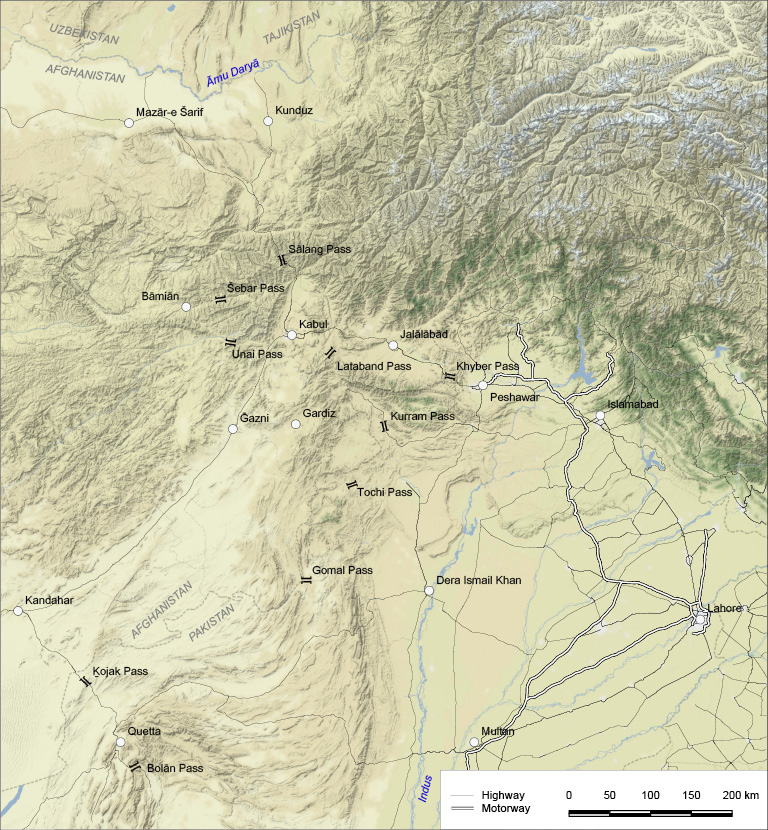
The Khyber Pass is located at 34° 01′ N, 71° 10′ E and runs through the Khyber Range, which is part of the Safēd Kōh (Safid Kuh; Pashto Spin Ḡar, the White Mountain), not to be confused with the Safēd Kōh in northern Central Afghanistan. The Khyber Range itself commences east of the Jalālābād plain and is joined by a ridge to the northern face of the Safēd Kōh. Rising on this connecting ridge, two small rivers, one flowing north-west to the Kabul River and the other south-east toward the Peshawar Valley at Jamrud, form the Khyber defile that separates the Khyber from the Bārā Range. Circumventing the gorges of the Kabul River, the Khyber Pass consists of a series of smaller mountain passages through a gorge and barren hills. Connecting the Afghan capital Kabul with Peshawar in Pakistan, the major part of the pass lies in the Khyber Agency in Pakistan’s Khyber Pashtunkhwa Province (formerly the Northwest Frontier Province, NWFP). The westernmost section of the pass extends into Afghanistan.
While the entire Khyber Pass runs over a distance of 33 miles between Jamrud in the east and the small town of Dakka (Lōya Daka) in the west, the Khyber proper spans over 25 miles in an east-west direction from Jamrud to Landiḵāna. Landi Kōtal, the highest point of the route located before the Landiḵāna section, was seen to mark the westernmost end of the Khyber proper. The following section from Landiḵāna to Dakka and Laʿlpura, the Ḵord Ḵaybar (Little Khyber), is characterized by a series of smaller, more level passes.
Over its entire distance, the pass has a relatively easy gradient along two torrent stream beds. The route is suitable for vehicles all the way. The two major points on the pass route are Jamrud and ʿAli Masjed. Located 10.5 miles west of Peshawar, Jamrud marks the eastern entrance point to the pass. However, the actual entrance of the Khyber defile is at Kadam (Qadam), a village 3 miles beyond Jamrud. Here the hills begin to encroach on the route, and the width diminishes to 450 feet. Further on, it narrows to 190 and then to 70 feet. At ʿAli Masjed, the width of the defile decreases to 40 feet, while the pass route is flanked by precipitous cliffs towering up to 1,300 feet on each side. Located 3,174 feet above sea level, the fort of ʿAli Masjed was built in the time of the Afghan ruler Dōst Moḥammad Khan (q.v.; r. 1826-39, 1842-63) on a conical hill 600 feet high on the southern side of the pass. The village and a small mosque of the same name are about eight miles from the entrance of the pass. ʿAli Masjed lies in a magnificent gorge traversed by a stream, which is largely dry except after a thunderstorm once or twice a year (Bayley, pp. 36-37). Beyond ʿAli Masjed, the Khyber Pass opens out into the Laʿl Bēg Valley (spelled Ghari Lalabeg in British sources) and widens to 1.5 miles, just to close in again in a narrow gorge with precipices rising on either side. The pass route reaches its highest point in Landi Kōtal (3,518 ft.). This small town is a bazaar center for the Afridi (q.v.) and Šinwāri, the major tribes of the Khyber area. Continuing on the connecting ridge of the Safēd Kōh, the following passage is called Landiḵāna (3,373 ft.). From here, the descent toward Dakka and the valley of Jalālābād (lying 1,404 ft. above sea level) is relatively easy (Markham, p. 255; MacGregor, vol. 2, pp. 126-130). The Khyber Pass route from Pakistan to Afghanistan ends at Tōrḵam (3.1 miles from Landi Kōtal), marking the crossing point on the Afghan-Pakistan border. Continuing beyond Tōrḵam on Afghan territory, the tail end of the pass finally opens up toward the broad valley of Mōhmand Darra, with the small place of Dakka on a branch of the Kabul River opposite the town of Laʿlpura in the Afghan province of Nangarhār.
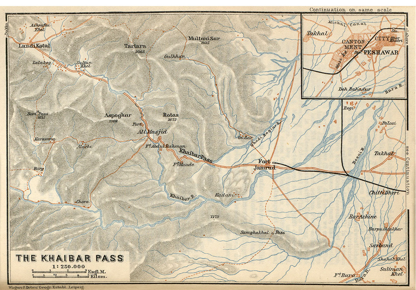
Figure 2. Map of the Khyber Pass, Karl Baedeker’s Indien: Handbuch fur Reisende, Leipzig, 1914.
History. Throughout history, the Khyber Pass has been a gateway to India, a strategic crossroads through which people, goods, and ideas, but also conquering armies, moved back and forth. In the 19th century, however, the pass became envisaged as a frontier by the British, who saw it as the sole key for the defense of their Indian possessions. The perception that as soon as one conqueror “had come and gone through the Khyber, another was on its heels” (Thomas, p. 83) harks back to that time. But in fact, various mountain passes such as the Kurram, Gōmal, Ḵojak, and Bōlān afforded a secure passage through the Solaymān Range. West of the latter, passages such as the Lataband, Unai (Ōnay), Šibar, Anjoman, Sālang and other mountain passages guarded the routes through the Hindukush (q.v.) toward Central Asia. Hence many conquerors sometimes used alternative routes to avoid the Khyber defile (Raverty, p. 38). In the 19th and 20th centuries, the image of the local inhabitants as notorious highway robbers greatly added to the perception of the Khyber as a frontier with forbidden Afghanistan.
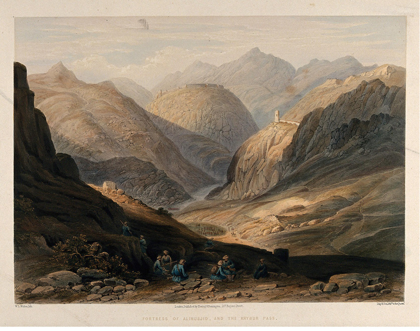
Figure 3. The Khyber Pass with the fortress of ʿAli Masjed, Pakistan. Chromolithograph by W. L. Walton after Lieutenant James Rattray, c. 1847. Credit: Wellcome Collection. Attribution 4.0 International (CC BY 4.0).
Since the military expeditions were usually targeted at the Indian subcontinent, the direction of military movement through the Khyber and the other passes was from west and northwest toward the Punjab or along the more southern route from Kandahar (q.v.) via the Ḵojak and Bōlān passes to Sindh. There were two types of military action via the Khyber and the neighboring passes. The first was instigated by landed powers endowed with large military and administrative machineries such as the Achaemenids and the Sassanids. Examples of Persian kings traversing the Khyber are Darius (r. 522-486 BCE), Ardašir (r. 225-41), Šāpur I (r. 241-72), Šāpur II (309-79) and Ḵosrow I Anōširavān (r. 531-78). Even the campaign of Alexander the Great in early 327 BCE falls into this category, though Alexander himself used an alternative route following the northern bank of the Kabul River, while his generals Hephaestion and Perdiccas moved through the pass.
The second category of military movement across the Khyber needs to be seen in the context of successive waves of nomadic invasions from the Central Asian steppes. Cases in point were the Saka (Scythians, q.v.), who had crossed the Oxus in the 130s BCE before being evicted from Bactria and other areas by the Yuezhi, who in the mid-1st century CE transformed into the Kushan (see KUSHAN DYNASTY). One of the last nomadic forces were the White Huns (also known as the Hephthalites, q.v.) traversing the pass into India in the mid-5th century.
It was very seldom that an Indian empire took the opposite direction and extended its grip to the areas west of the Khyber Pass. In many ways, it was not the pass or the Solaymān Range but the Indus Valley that formed the frontier separating Indian, Persian, and Greek spheres of influence. One of the very few Indian exceptions was the Maurya king Čandragupta (r. 321-297 BCE), who in 305 BCE gained control over the pass not by military force but by diplomacy (Docherty, pp. 52-53).
After the decline of the Mauryan and Seleucid empires around 250 BCE, Greeks, Sakas, Parthians, Kushans, White Huns and Sassanids contested the pass and the neighboring areas. In that period, several patterns can be observed. The first is the dominance of Greek culture filtering through the Khyber and the other mountain passages into India. The second tendency is the spread of Buddhism, or more precisely Mahayana Buddhism (The Great Vehicle) in the opposite direction, a development that reached its climax under the Kushan emperor Kanishka (r. 129-140/50). The third pattern is transregional trade flourishing despite frequent military activities. The passes were arteries for a branch of the Silk Road connecting the Indus Valley and the Punjab with Bagram and Bactria further in the north.
In the Islamic period, the historical patterns of trade and military movement continued. Examples of Muslim conquerors who invaded India through the Khyber and other nearby passes are Maḥmud of Ḡazna (r. 999-1030) and his son Masʿud (r. 1030-40), the Ghurid (q.v.) ruler Moʿezz-al-Din (r. 1173-1206), Timur (r. 1370-1405), Bābor (1483-1530), and Nāder Shah (r. 1736-47). Whereas the conquests by Maḥmud and Moʿezz-al-Din laid the foundation of Islamic dynasties in India, the Mongols, albeit non-Muslims when traversing the Khyber in the second half of the 13th century, fit into the ancient nomadic mold of movement and conquest. Three centuries later, the Mughals paid great attention to the route. Yet their efforts to establish lasting control over the pass met with no success. During the reign of Akbar I (q.v.; r. 1556-1605), the road was improved so that the traffic was considerably eased. In spite of this, the Khyber region was affected by the activities of the Rowšaniya sect, which enjoyed great influence among the local Pathan inhabitants throughout the 16th century. In 1672, the Afridi (q.v.) annihilated a Mughal army and captured its baggage train. Afterwards, the pass remained closed for two years until Awrangzēb himself was able to put down the rebellion.
The last in the chain of great Islamic conquerors leading their troops across the Khyber Pass was Aḥmad Shah Abdāli (r. 1747-72; see ABDALI, DORRĀNI, AFGHANISTAN x). Between 1747 and 1767, the Dorrāni ruler mounted nine expeditions to India, though he sometimes also moved through Baluchistan to establish sway over the lower Indus Valley. Although his successors Timur Shah (r. 1772-93) and Zamān Shah (r. 1793-1800) also directed their military activities at the region beyond the Solaymān Range, their campaigns were of no lasting consequence (Noelle-Karimi, 2014, pp. 111-13). At the same time, Afghan control over the pass was often nominal as the local inhabitants, acting as wardens of the Khyber, largely retained their independence. The Khyber area was and still is populated by several major Pathan (Pashtun) tribes: the Afridis inhabiting the eastern section of the pass; the Šinwāris in control of the western portion beyond Landi Kōtal; and the Orakzais, the immediate neighbors of the Afridis in the upland valleys adjoining the Khyber Range.
The Khyber in the 19th and 20th Centuries. From the late 18th century on, more information on the surrounding countries and tracts of land became available. The first detailed survey of the defile was provided by Lieutenant Robert Leech, whose map from 1837 charted the entire length of the route from Jamrud to Dakka. By the mid-1830s, the Dorrāni rulers of Kabul had lost control over the lands east of the pass to the Sikh ruler Ranjit Singh (r. 1801-39). In 1836, the Sikh general Hari Singh constructed the fort of Jamrud to strengthen the frontier protection of the Sikh kingdom on the Khyber road. A year later, the Afghan ruler Dōst Moḥammad Khan asserted his claims to supremacy over the region after the Afghan-Sikh battle in Jamrud (Noelle, 1997, p. 168). Prior to the first Anglo-Afghan War (1838-42; see ANGLO-AFGHAN WARS), British agents usually avoided the pass for reasons of safety (Burnes I, p. 113). During the war, the British and the Sikh faced heavy resistance (in 1839), and even later continued attacks by the Khyber tribes, particularly the Afridi, rendered British control over the pass precarious. After the war, control over the Khyber passed back to the Afghans. Yet, as in the time before, the Kabul rulers paid annual allowances to the tribes to keep the pass open and secure the route.
Afghan supremacy over the pass ended with the Second Anglo-Afghan War (1878-80). With the Treaty of Gandomak (q.v.) concluded in 1879, the Khyber region fell to British India. Afterward, the British continued the policy of paying large sums to the local tribes to keep the route open (Noelle, 1997, p. 171; Haroon, pp. 22-23). The establishment of the Durand Line in the 1890s cemented this state of affairs. In the 19th century, there were two principal routes through the pass: proceeding on the right side, the first was called Kōtal Šādi Baḡiyāri and was so narrow that it could be used only by men on foot and camels. The second, left-hand road, usually taken by the Afghan troops (until 1878), went by the bed of the Jam River near Kadam. In the 1920s, the pass route consisted of three parallel roads that had been improved by the British: the first was reserved for motor vehicles; the second was frequented by camel caravans and other beasts of burden; the third road was used exclusively by troops and trucks.
In the 1880s, not only roads, but also railways and telegraph lines were constructed through the frontier to develop and secure the region against possible Russian military threats. Between 1884 and 1900, more than 100 million rupees were spent on the construction of railroads through the Tribal Areas to open up routes through the Khyber and Bōlān passes. By 1900 the North Western Railway system reached close to Jamrud. In 1905, the construction of the Khyber Railway started at Kača Garhi between Peshawar and Jamrud. However, the project stopped after two years for political reasons and was resumed after the Third Anglo-Afghan War in 1919. Construction of a broad gauge line (1676 mm) restarted in 1920 and finished with the inauguration of the section between Jamrud and Landi Kōtal in November 1925. In spring 1926, another section of almost five miles, extending to Landḵāna, was opened. Yet this section was closed down in late 1932 at the insistence of the Afghan government. The Khyber Railway was the last of the great railway projects on the frontier during the British Raj. It consists of four reversing stations, thirty-four tunnels, ninety-two bridges and culverts, and four locomotive watering stations.
With the end of British rule on the Indian subcontinent in 1947, the Khyber Pass fell to the new state of Pakistan. From 1947 on, Pakistan Railways continued a weekly passenger service through the pass. Its regular service stopped in 1982 because of a lack of commercial patronage. In the 1990s, a private company launched the Khyber Steam Safari in collaboration with Pakistan Railways.
Bibliography
L. W. Adamec, Historical and Political Gazetteer of Afghanistan VI: Kabul and Southeastern Afghanistan, Graz, 1985.
Idem, Historical Dictionary of Afghanistan, 2nd ed., London, 1997.
V. Bayley, Permanent Way through the Khyber, London, 1939.
P. S. A. Berridge, Couplings to the Khyber: The Story of the North Western Railway, Newton Abbot, 1969.
A. Burnes, Travels into Bokhara: Being the Account of a Journey from India to Cabool, Tartary and Persia, 3 vols., London, 1834.
O. Caroe, The Pathans: 550 B.C.-A.D. 1957, London, 1964.
P. Docherty, The Khyber Pass: A History of Empire and Invasion, London, 2007.
L. Dupree, Afghanistan, Princeton, 1980.
M. Elphinstone, An Account of the Kingdom of Caubul and Its Dependencies in Persia, Tartary, and India, London, 1815; repr. Graz, 1969.
K.-H. Golzio, Geschichte Afghanistans von der Antike bis zur Gegenwart, Berlin, 2010.
R. Gopalakrishnan, The Geography and Politics of Afghanistan, New Delhi, 1982.
S. Haroon, Frontier of Faith: Islam in the Indo-Afghan Borderland, London, 2007.
D. M. Hart, Guardians of the Khaibar Pass: The Social Organisation and History of the Afridis of Pakistan, Lahore, 1985a.
Idem, Qabila: Tribal Profiles and Tribe-State Relations in Morocco and on the Afghanistan-Pakistan Frontier, Amsterdam, 1985b.
I. S. Hussain, Some Major Pukhtoon Tribes along the Pak-Afghan Border, Islamabad, 2000.
Imperial Gazetteer of India, Provincial Series: North-West Frontier Province, Lahore, 1991.
F. K. Khan, A Geography of Pakistan: Environment, People and Economy, Karachi, Oxford & New York, 1991.
C. M. MacGregor, Central Asia, Part I, 3 vols., Calcutta, 1973.
M. B. K. Malik, Hundred Years of Pakistan Railways: Pakistan Western Railway 1861–1961, Pakistan Eastern Railway 1862–1962, Karachi, 1962.
C. S. R. Markham, “The Mountain Passes on the Afghan Frontier,” Proceedings of the Royal Geographical Society 1/1, 1879, pp. 38-62; reprint in N. Hatch Dupree, ed., Afghanistan, Essex, 1972, pp. 250-72.
C. Masson, Narrative of Various Journeys in Balochistan, Afghanistan, the Panjab and Kalât, 3 vols. (particularly Vol. I), London, 1844.
O. Mughal, “Khyber Pass Railway,” The
Indian Railways Fanclub (IRFCA), 2006, www.irfca.org/articles/khyber-pass-railway.html (accessed on 20 September 2018).
C. Noelle[-Karimi], State and Tribe in Nineteenth-Century Afghanistan: The Reign of Amir Dost Muhammad Khan (1826-1863), Richmond, U.K., 1997.
Idem, The Pearl in its Midst: Herat and the Mapping of Khurasan (15th-19th Centuries), Vienna, 2014.
E. E. Oliver, Across the Border or Pathan and Biloch, London, 1890.
H. G. Raverty, Notes on Afghanistan and Baluchistan, 2 vols., 2nd ed., Quetta, 1982.
S. I. A. Shah, “The Derailed Safari Train: One of the Five Celebrated Trains of Asia Calls for Immediate Attention,” Daily Jang, News on Sunday 3 (TNS): Political Economy, 20 April 2008, https://jang.com.pk/thenews/apr2008-weekly/nos-20-04-2008/pol1.htm#4 (accessed on 20 September 2018).
J. W. Spain, The Pathan Borderland, Karachi, 1993.
L. Thomas, Beyond Khyber Pass into Forbidden Afghanistan, New York, 1925.
D. N. Wilber, Afghanistan, New Haven, 1956.
M. Yapp, “Tribes and States in the Khyber, 1838-42,” in Richard Tapper, ed., The Conflict of Tribe and State in Iran and Afghanistan, New York, 1983, pp. 150-91.