

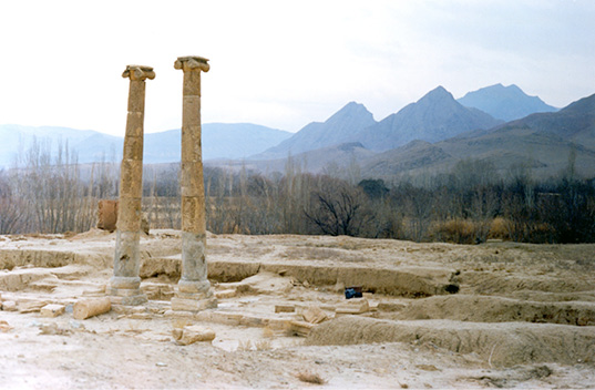
KHORHEH (Ḵurha), a village in the central district (baḵš) of Maḥallāt county (šahrestān), 223 km south of Tehran, 73 km southwest of Qom, and 12 km southwest of the village of Do Dehak on the Tehran-Isfahan road. An archaeological site from the Arsacid era lies at an altitude of 1200 m, in a plain bordered by mountains and irrigated by the seasonal Qomrūd river. The most distinctive aspect of the site is the presence of two standing stone columns with their Ionic capitals (PLATE I), which have been mentioned in historical records.
Early explorations. Ḥasan Qomi, the author of Tāriḵ-e Qom, written in 988 CE, gives the earliest description of the ruins: “Khorheh is a village originally founded by Alexander. There are four columns made of round pieces of stone and equal in size in which there is no imperfection or crack can be seen, as if they were cut in one single piece. It is said that these columns were topped by domes (qobba), now collapsed” (ed. Tehrāni, p. 69; ed. Anṣāri Qomi, p. 204).
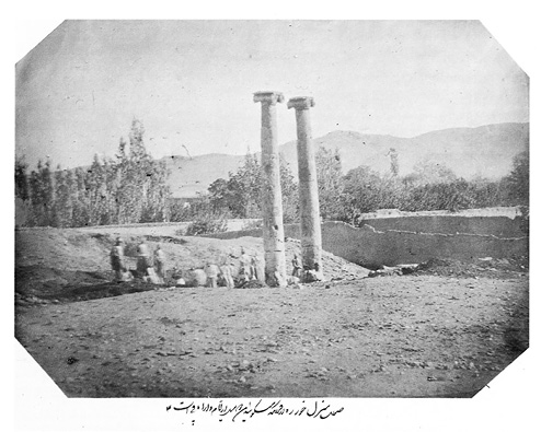
Later historical descriptions do not mention the ruins until the mid-19th century, when they attracted Nāṣer-al-Din Shah’s attention during his journey to Qom, Kurdistan, Solṭāniya, and Azarbaijan in the summer of 1859. A series of photographs were taken during that trip, of which two have survived (Adle, pls. 3-4). There is also a pencil drawing of the two standing columns, probably by Nāṣer-al-Din Shah himself (Adle, pl. 2). The shah’s entourage hired eleven workers to undertake a limited excavation in the area where the columns stood. There is no formal report on this first excavation at Khorheh. However, the Qajar king, himself an enthusiast in regard to photography and ancient ruins, put photography at the service of archaeology during that first Iranian excavation at Khorheh, where the work in progress was documented with photographs (PLATE II). The resulting album, prepared and presented to the shah on 20 March 1860, on the occasion of Nowruz, is preserved in the Golestān Palace Library (MS 679/7703) in Tehran.
Nāṣer al-Din Shah’s second campaign of excavation at Khorheh began on 31 May 1892, thirty-three years after his initial visit, during his trip to central Iran. Still perplexed by the presence of the columns, he ordered a team to be formed to study them. This time, Moḥammad Ḥasan Khan Eʿtemād-al-Salṭana, the minister of press and publication (wazir-e enṭebāʿāt) and director of the Translation Bureau (Dār al-tarjama-ye ḵāṣṣa-ye dawlati), was charged by the king to send a group of photographers to Khorheh to take better photographs. The shah’s photographic expeditions reveal the situation of the site as it then existed, with an open area in front of the colonnaded portico. In addition, a flat mound behind the columns can be seen in the photographs, the upper layers of which were unfortunately removed during the shah’s hasty uncovering of the monument.
Located off the main Qom to Isfahan road, Khorheh hardly appears in travelers’ books except for two accounts. In 1881, Edward Stack of the Bengal Civil Service traveled in Persia and briefly visited the ruins and noticed Nāṣer al-Din Shah’s excavations: “As we drew near Khurha, we passed two stone pillars with capitals that seemed Ionic … The stone seemed to be a hard kind of limestone. The capitals are Ionic, but adorned on two sides with horizontal dice boxes of stone, or rolls tied tightly in the middle. Remains of a fort of unhewn stone stand close by. As usual, the people were as ignorant as myself of the history of these relics; but it seemed to be a fact that the Shah had encamped here some twelve years ago, had overset a number of the pillars, and had broken up the stone flooring of the colonnade, in the vain hope of finding treasures” (Stack, II, pp. 129-30).
More than a decade later, the German scholar, Albert Houtum-Schindler, then in the service of the Qajar government, published his description of the ruins, which generally agrees with the description given by Stack: “About a quarter of a mile south of Khurheh, on a little hill, are the ruins of a Sassanian temple. The villagers call them the palace of Khorremshah, who was king a thousand years ago, and add that, after his death, the palace became a burial place. Two unfluted columns, each composed of six pieces of polished limestone, are still standing; two others fell down ‘seven, or seventy, or perhaps seven hundred years ago’” (pp. 98-99).
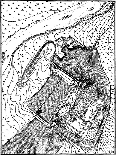
The archaeological exploration. In 1920, Ernst Herzfeld wrote that Khorheh was a Seleucid temple complex and published two photographs of the columns then in possession of Friedrich Sarre (p. 32, pl. XVII). Based on the photographs, he assumed that the monument had only two stone columns in the facade of a temple in antis, the walls of which were in mud-brick and stone. He later visited the ruins in October 1923 and thought that the building was a temple of Dionysus built on stylobates with a peristyle colonnade bordering a central shrine, as he contemptuously wrote about the remains: “The valley of Khurha, where the third monument stands, is full of vineyards, and the mounds of the temple area are strewn with sherds of large pithoi (wine-jugs). The building was a temple. Worked square stones lie around everywhere. The peribolos can still be traced; the temple itself, inside that colonnade, ought to be excavated” (1934, pp. 50-51). He later published better photographs and a general map of the site (1941; Figure 1).
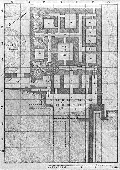
Ali Hakemi’s excavations in the summer of 1955, although not published until 1990, showed that the monument at Khorheh consisted of two major components: a main building in the south with the colonnade (Figure 2), its adjacent rooms, and a courtyard; and a northern building with passages and a large central room (Hakemi, 1990, pp. 16-23). A third architectural complex, located some 250 m west of the main remains, is yet to be explored. The main complex is a mud-brick building on stone foundations, 50 x 35 m, the corners of which are oriented toward cardinal points. On the southeastern edge of the building, there is a colonnaded portico, 19.28 x 6.50 m in size and 12 columns. The paved portico sits on a four-meter stone platform made of four dressed blocks of stones. The columns consist of a column base made of two parallelepiped blocks and a round torus, the shaft made of six pieces, and the Ionic looking capitals that include bobbin-shaped volutes surmounted by an abacus. In design, the columns resemble Ionic columns of Greece, but the stone-cutting techniques and proportions are of local craftsmanship.
Klaus Schippmann (p. 430), without finding any evidence for ascribing the ruins to the Seleucids, suggests comparing the “Temple” at Khorheh with that of Kangavar. However, results obtained from systematic archaeological excavations at Khorheh refute the identification of the site with a Seleucid or Greco-Iranian temple.
Wolfram Kleiss conducted surveys at Khorheh in 1973 and in 1981 and published sketches and ceramic drawings. Kleiss writes that while the facade with its colonnade had an evocative aspect, there are annexes, storage rooms, and living rooms that are likely to be located in the south (1985, p. 177). It is a courtyard type building and was possibly a palace as Kleiss suggests and gives a reconstruction of the colonnaded building (1994, pp. 209-10).
Further excavations by Mehdi Rahbar in 1976, 1996, 2000, and 2003, on behalf of the Iranian Center for Archaeological Research, revealed terraces in front of the colonnaded portico on the south side of the main complex (Rahbar, 1999; 2003; ʿAlāʾi Moqaddam and Bani Jamāli, pp. 175-76). The excavations also showed that the walls of important structures such as the central square hall north of the colonnaded portico were covered with plaster and stuccos that had been severely destroyed. Most of the structures were vaulted, and Rahbar identified at least the remains of a large, mud-brick vaulted corridor, 170 cm high.
The excavations yielded a considerable quantity of Parthian ceramics, notably Clinky Ware (see CERAMICS xii. THE PARTHIAN AND SELEUCID PERIODS), with no noticeable Seleucid or earlier ceramics (Saurat, p. 45; Kleiss, 1985, p. 178; Haerinck, p. 93; Rahbar, 2003, p. 10). According to Rahbar (1999), the monumental complex at Khorheh was a royal pavilion or manor house of a local lord on the main axis of communication between Hamadān/Ray and Isfahan, which would be typical of a certain type of Arsacid-period manors (cf. Wright; Lecuyot; Hauser, pp. 82-83). Ceramic finds and architectural remains suggest a 2nd to 3rd century date for Parthian Khorheh. The site does not seem to have been occupied after the decline of the Parthians and was later covered by tombs of the 8th century at the latest, before its definitive abandonment.
Bibliography
Herzfeld’s photographs and papers on Khorheh are kept in the Freer Gallery of Art and Arthur M. Sackler Gallery Archives, Smithsonian Institution, Washington, D.C., The Ernst Herzfeld Papers, Subseries 4.7: Photo File 7 (2 vols.) “Sasanian Architecture,” accessible at http://collections.si.edu/search/results.htm?view=grid&dsort=&date.slider=&q=Ernst+Herzfeld+Khurha.
Chahryar Adle, “Ḵurha, ṭaliʿa-ye kāvoš-e ʿelmi-ye Irāniān/Khorheh: The Dawn of Iranian Scientific Archaeological Excavation,” Tavoos Quarterly 3-4, 2000, pp. 4-43 (Persian), 226-39 (English).
Javād ʿAlāʾi Moqaddam and Sayyeda Layla Bani Jamāli, “Faʿāliyat-hā-ye bānstān-šenāḵti-ye šahrestān-e Maḥallāt,” in Yusof Ḥasanzāda and Simā Miri, eds., Majmuʿa maqālāt-e 80 sāl bāstānšenāsi-ye Irān I, Tehran, 2012, pp. 171-84.
E. Haerinck, La céramique en Iran pendant la période parthe (ca. 250 av. J.C. à ca. 225 après J.C.), typologie, chronologie et distribution, Ghent, 1983.
Ali Hakemi, “The Excavation of Khurha,” East and West 40/1, 1990, pp. 11-41.
Stefan R. Hauser, “Basileia and Royal oikoi: Remarks on Arsacid Palaces and Palace Culture,” Der Palast im antiken und islamischen Orient: 9. Internationales Colloquium der Deutschen Orient-Gesellschaft, 30. März-1. April 2016, Frankfurt am Main, Wiesbaden, 2019, pp. 73-89.
Ernst Herzfeld, Am Tor von Asien: Felsdenkmale aus Irans Heldenzeit, Berlin, 1920.
Idem, Archaeological History of Iran, London, 1934.
Idem, Iran in the Ancient East: Archaeological Studies Presented in the Lowell Lectures at Boston, London and New York, 1941.
Albert Houtum-Schindler, Eastern Persian Irak, London, 1897.
Wolfram Kleiss, “Qalʿeh Zohak in Azerbaidjan (Tafeln 41-43),” Archaeologische Mitteilungen Aus Iran 6, 1973, pp. 163-88.
Idem, “Bemerkungen zum Säulenbau von Khurha,” Archaeologische Mitteilungen Aus Iran 14, 1981, pp. 65-68.
Idem, “Der Säulenbau von Khurha,” Archaeologische Mitteilungen Aus Iran 18, 1985, pp. 173-79.
Idem, “Beobachtungen in der Umgebung von Dodehak (Taf. 39-41, 2),” Archaeologische Mitteilungen aus Iran 27, 1994, pp. 205-21.
Guy Lecuyot, “Résidences hellénistiques en Bactriane, résidences parthes en Iran et en Mésopotamie: Diffusion ou communauté d’origine?” Mesopotamian History and Environment, Série 1. Northern Akkad Project Reports (NAPR) 8, Ghent, 1993, pp. 31-45.
Ḥasan b. Moḥammad Qomi, Tāriḵ-e Qom, ed. Sayyed Jalāl-al-Din Tehrāni, Tehran, 1982; ed. Moḥammad Reżā Anṣāri Qomi, Tehran, 2006.
Mehdi Rahbar, “Khorheh, une résidence d’époque parthe sur le plateau iranien,” Les Dossiers d’Archéologie 243, 1999, pp. 44-46.
Idem, Kāvošhā-ye bāstānšenāsi-ye Ḵurha, Tehran, 2003.
Benjamin Rowland, “Notes on Ionic Architecture in the East,” American Journal of Archaeology 39/4, pp. 489-96.
Anne Saurat, Exposition des dernières découvertes archéologiques, 1973-1974, Musée Iran Bastan, Centre Iranien de Recherches Archéologiques, Tehran, 1974.
Klaus Schippmann, Die iranischen Feuerheiligtümer, Berlin, 1971.
Edward Stack, Six Months in Persia, 2 vols., London, 1882.
G.R.H. Wright, “Abu Qubur: The ‘Parthian Building’ and its Affinities,” in H. Gasche et al. eds., Northern Akkad Project Reports (NAPR) 7: Fouilles d’Abu Qubur, Ghent, 1991, pp. 75-91.